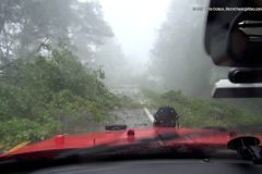
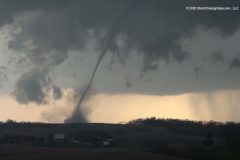
New footage of the High Precipitation or HP Super-Cell thunderstorm with a large, violent tornado, wrapped in rain at close range, along with aftermath footage in Mississippi.
Shot Description
1. View of a weak possible tornado over Natchez, MS.
2. Shots near the bridge clearing, looking north from Garden City, MS (3 shots).
3. RFD and approaching passing tornado between Garden City and Roxie.
4. Strong winds and tree debris/roadway blocked (2 shots).
5. Tornado path on I-55 south of Brookhaven, MS at dusk.
SID: CHRISTOPHER COLLURA
#tornado #Mississippi #weather #aftermath
To help support our freelancers, buy them coffee. https://www.buymeacoffee.com/stormchasing/
To License This Footage For Broadcast, Contact Video @ StormChasingVideo.com
Our Team Merch Store – https://stormchasingvideo.creator-spring.com
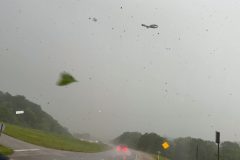
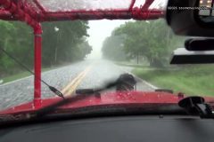
Raw Video from a motorist who was caught in the rain-wrapped tornado that hit Mineral Wells, Texas. The rain-wrapped tornado was near Highway 180, and large debris was raining down on top of them as they tried to escape the area.
#Tornado #Texas #mineralwells #stormchasers
To help support our freelancers, buy them coffee. https://www.buymeacoffee.com/stormchasing/
To License This Footage For Broadcast, Contact Video @ StormChasingVideo.com
Our Team Merch Store – https://stormchasingvideo.creator-spring.com
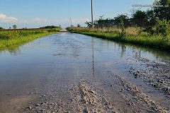
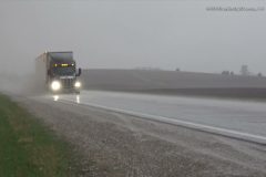
Video captured in Mexico and Centralia, Missouri, located in Central Missouri, showing flooding across Audrain County after they received around 1.96 inches of rain since 7 am today and around 2.66 inches between midnight Monday and 5 pm, in about 17 hours. The heavy rain and flooding prompted a flash flood warning from the National Weather Service in St. Louis, issued around 11:48 AM and lasting until 2:45 PM after 1-2 inches of rain had fallen.
Shot Description
00:00 Close and medium shots showing heavy rain falling on the front of a vehicle on Monday afternoon in Centralia, Missouri.
00:30 Close-up shot of ponding water forming as heavy rain continues to fall, with the next clip showing a wide shot of a ditch completely flooded and beginning to overflow as heavy rain is actively falling.
00:52 Sign on the side of the road saying the road is impassable during high water.
01:03 A wide and medium shot of signs in the ditch used to measure how deep the flood waters are on the roadways. In the videos, you can see flash flooding in the ditches just short of where the measurement signs begin.
01:24 Two clips of a vehicle driving through flood waters on the roadway.
01:53 Three clips of high water flowing under the roadway with caution tape and cones marking the edge of the road or ditch following the heavy rains.
02:11 Various clips showing the fast-moving flood waters along the side of the road and through a fence.
02:49 Video showing a partially flooded pasture with cows standing along the edge of the flood waters.
02:57 Video of a golden retriever walking through the flood waters of a river or stream that flooded over its banks, and up to the edge of the fast-moving flood waters.
03:11 In this clip, the same golden can be seen running away from the fast-moving flood waters and playing in the water.
03:19 Various medium and wide shots showing a flooded roadway and water flowing across the road following the heavy rains.
03:50 Additional wide and medium shots showing the fast-moving and flooded ditches from the heavy rains.
04:13 Video of a neighbor driving an ATV through the flooded roadway following the heavy rains, after they had checked out the flooding.
04:21 Additional clips showing a completely flooded roadway flowing over the road.
05:13 Video of a guy walking out into a flooded farm field. Based on the boots the man was wearing, the water was roughly 15-18" deep in spots.
05:39 Wide shots showing the farm field completely flooded following the heavy rains.
06:04 Two more clips showing water flowing across a roadway following the heavy rains.
06:20 The final three clips are medium and close-up shots of a rain gauge just before a measurement was taken around 5 PM, showing around 1.96 inches of rain since 7 am Monday morning.
SID: Sara Bruce
#MOWX #FlashFlooding #flooding
To help support our freelancers, buy them coffee. https://www.buymeacoffee.com/stormchasing/
To License This Footage For Broadcast, Contact Video @ StormChasingVideo.com
Our Team Merch Store – https://stormchasingvideo.creator-spring.com
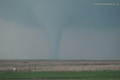
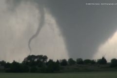
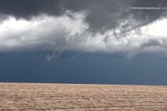
Video of the Twin tornadoes near Shidler, Oklahoma that touched down Sunday Night.
Shot Description
1. First tornado forms (several tight and wide shots).
2. Funnel.
3. Twin tornadoes (3 shots).
4. Panning view of supercell storm flanking line.
5. Driving with funnel and front of vehicle.
6. Supercell low level meso.
SID: CHRISTOPHER COLLURA
#okwx #tornado #tornadoes #stormchasers
To help support our freelancers, buy them coffee. https://www.buymeacoffee.com/stormchasing/
To License This Footage For Broadcast, Contact Video @ StormChasingVideo.com
Our Team Merch Store – https://stormchasingvideo.creator-spring.com
Severe supercell storms with large hail in Garvin and Johnston County, Oklahoma.
Shot Description
1. Video ID slug.
2. Shot of laptop and start of hail near Pauls Valley.
3. Supercell wall cloud.
4. Small to moderate hail in grass.
5. View of RFD and wall cloud area looking north.
6. Shots of very large hail near Wapanucka (3 shots).
SID: CHRISTOPHER COLLURA
#stormchasers #okwx #supercell #hailstorm #hailstorm
To help support our freelancers, buy them coffee. https://www.buymeacoffee.com/stormchasing/
To License This Footage For Broadcast, Contact Video @ StormChasingVideo.com
Our Team Merch Store – https://stormchasingvideo.creator-spring.com
Chase video of the Bramen, Oklahoma, Kay County tornadic supercell and evolution into the vivid tornado.
#okwx #tornado #supercell #stormchasers
To help support our freelancers, buy them coffee. https://www.buymeacoffee.com/stormchasing/
To License This Footage For Broadcast, Contact Video @ StormChasingVideo.com
Our Team Merch Store – https://stormchasingvideo.creator-spring.com
Footage of a tornado on the Southeast side of Rochester, Minn., that ripped the roofs off homes and did significant damage to the area.
Shot Description
0:00 – Tornado going over hillsides of Rochester, Minnesota, causing damage to houses and trees.
1:05 – Tornado damage of multiple houses with roofs torn off and partial second levels of homes, as well as a lot of downed trees and debris.
SID: Jarrod Schoenecker
#tornado #MNWX #stormchasing #stormdamage
To help support our freelancers, buy them coffee. https://www.buymeacoffee.com/stormchasing/
To License This Footage For Broadcast, Contact Video @ StormChasingVideo.com
Our Team Merch Store – https://stormchasingvideo.creator-spring.com
Morning severe 1 inch plus hail in rural Le Sueur County west of Kilkenny, Minn.
Shot List:
0:00 – 1 inch plus hail bouncing off of bare field and grass
0:25 – 1 inch plus hail falling and a semi-truck driving by
SID: Jarrod Schoenecker
To help support our freelancers, buy them coffee. https://www.buymeacoffee.com/stormchasing/
To License This Footage For Broadcast, Contact Video @ StormChasingVideo.com
Our Team Merch Store – https://stormchasingvideo.creator-spring.com
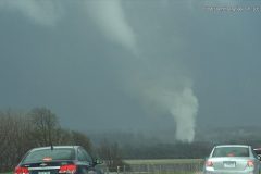
More tornadoes and dangerous supercell thunderstorms over the Midwest, including Iowa.
All footage shot near the community of Monmouth, Iowa, during evening daylight on April 14, 2026 by Meteorologists and Storm Chasers Juston Drake and Simon Brewer
Shot Description
00:00 rope-shaped tornado
00:25 debris cloud with tornado
01:05 rapidly rotating wall cloud
01:30 tornadic supercell with wall cloud
SID: Simon Brewer Juston Drake
To help support our freelancers, buy them coffee. https://www.buymeacoffee.com/stormchasing/
To License This Footage For Broadcast, Contact Video @ StormChasingVideo.com
Our Team Merch Store – https://stormchasingvideo.creator-spring.com
Brand new raw footage from Connor Healey of the extremely close range tornado that touched down near Onslow, Iowa this evening.
#onslow #iowa #iawx #Tornado #weather
To help support our freelancers, buy them coffee. https://www.buymeacoffee.com/stormchasing/
To License This Footage For Broadcast, Contact Video @ StormChasingVideo.com
Our Team Merch Store – https://stormchasingvideo.creator-spring.com
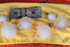
Tornado and baseball sized hail strikes near Truman, Minnesota during a significant severe weather outbreak.
All footage shot near Truman, Minnesota, during evening daylight on April 13, 2026, by Meteorologists and Storm Chasers Juston Drake and Simon Brewer
Shot Description
00:00 cone tornado
01:17 baseball-sized hail
SID: Simon Brewer Juston Drake
#Torando #MNWX #Minnesota #hail
To help support our freelancers, buy them coffee. https://www.buymeacoffee.com/stormchasing/
To License This Footage For Broadcast, Contact Video @ StormChasingVideo.com
Our Team Merch Store – https://stormchasingvideo.creator-spring.com
Footage of a tornado and a hailstorm. See clips for location information, as most of the footage was shot near Truman, MN, except for some of the hail that was shot near Bingham Lake, Minnesota.
Shot Description
00:00 – Tornado Near Truman, MN
01:26 – Tornado Near Truman, MN
02:02 – Baseball-sized hail after it fell in Bingham Lake, MN
02:14 – Hail covering the ground at sunset north of Truman, MN with hail fog.
02:43 – Three Clips, POV Driving in hail in Cottonwood County, MN.
04:14 – POV long clip of driving in hail and heavy hail fog north of Truman, MN
SID: TJ Kleckner & Doug Kiesling
#MNWX #Tornado #hail #hailstorm
To help support our freelancers, buy them coffee. https://www.buymeacoffee.com/stormchasing/
To License This Footage For Broadcast, Contact Video @ StormChasingVideo.com
Our Team Merch Store – https://stormchasingvideo.creator-spring.com
Rope-shaped tornado near West Liberty, Iowa touches down this afternoon..
Shot Description
00:00 – 01:06 Video of a long rope Tornado out the side window while driving.
01:06 – 01:36 Funnel cloud over the tree line.
SID: Simon Brewer Juston Drake
To help support our freelancers, buy them coffee. https://www.buymeacoffee.com/stormchasing/
To License This Footage For Broadcast, Contact Video @ StormChasingVideo.com
Our Team Merch Store – https://stormchasingvideo.creator-spring.com
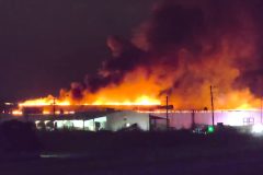
Massive roof fire on the large north building in the Fuyao Glass Factory (formerly General Motors Truck Assembly and even further back Frigidaire) in Moraine, Ohio.
As of now, it looked out of control, but confined to the northernmost building in the complex. An elevated squall line is moving over now with heavy rain, but not sure if that will help much. A massive cloud of toxic smoke is blowing over eastern Moraine and Miami Township.
Shot Description
One long clip driving by the fire.
SID: Simon Brewer
#OHWX #FactoryFire #GM #fuyao
To help support our freelancers, buy them coffee. https://www.buymeacoffee.com/stormchasing/
To License This Footage For Broadcast, Contact Video @ StormChasingVideo.com
Our Team Merch Store – https://stormchasingvideo.creator-spring.com
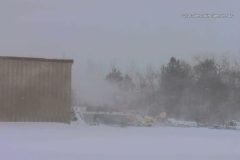
This Sunday brought near whiteout conditions and roads almost completely covered in snowdrifts across Barron County. A blizzard warning was in effect for much of the day. By evening, 8 to 12 inches of snow had fallen across the area, with some spots seeing less and others getting even more. Winds were gusting 25 to 40 mph at times.
Shot Description
Clip 1. Dashcam footage of the blowing snow.
Clips 2-3. Blowing and falling snow.
Clip 4. Dashcam footage of a road starting to drift shut. People also checking out the snow drifts.
Clip 5. Further up the same road. The drifts are getting to be more and deeper.
Clip 6. Same road is now drifted over.
Clip 7. Snow blowing off a roof.
Clip 8. Barron County HWY department keeping HWY 48 west of Rice Lake, WI. plowed.
Clips 9-10 Blowing snow with near whiteout conditions.
Clip 11. About 6 miles east of the city of Rice Lake, Blowing snow with a little snownado.
Clip 12. Another road that is drifted shut.
Clip 13. This part of the same road from clip 12 is also starting to drift over.
SID: Dirk Miller
#Blizzard #weather #wiwx #winter
To help support our freelancers, buy them coffee. https://www.buymeacoffee.com/stormchasing/
To License This Footage For Broadcast, Contact Video @ StormChasingVideo.com
Our Team Merch Store – https://stormchasingvideo.creator-spring.com
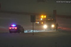
Footage shot around the Twin Cities Metro area of hazardous traffic conditions along Interstates 94 and 35, including numerous vehicle crashes.
Shot Description
00:00 – Several clips of a snow plow accident on Interstate 94.
00:42 – Blizzard warning sign over Interstate 94.
00:58 – A semi truck spun out and crashed in the middle of Interstate 94.
01:08 – Two clips of an SUV that slid off into the ditch from a cloverleaf on 494 in Eden Prairie.
01:27 – Two clips of a Big Rig tractor (no trailer) stuck on a cloverleaf on Interstate 35w and Hwy 13.
01:50 – Two clips of a car that crashed into the center median on 494 in Eden Prairie.
02:08 – Minneapolis, MN downtown skyline in heavy snow.
02:22 – A pickup truck crashed into the ditch along Interstate 94.
02:31 – POV shots of tandem snow plow on 494 in Eden Prairie.
02:51 – POV Shot of an EMS crew checking on someone who crashed in the ditch on 494.
03:00 – Crash scene POV drive-by on Interstate 35w.
#MNWX #blizzard #weather #winterstorm
To help support our freelancers, buy them coffee. https://www.buymeacoffee.com/stormchasing/
To License This Footage For Broadcast, Contact Video @ StormChasingVideo.com
Our Team Merch Store – https://stormchasingvideo.creator-spring.com
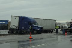
Late Tuesday morning, February 24, 2026, a quick-moving clipper brought a mix of freezing rain and light snow across the Twin Cities Metro, quickly making roads icy and causing travel headaches all across the metro. The following video was captured from Bloomington, Burnsville, and Eagan, in Dakota and Hennepin Counties in Minnesota, and shows just a few of the crashes and incidents across the southern Twin Cities resulting from the freezing rain and light snow.
Shot Description
00:00 Video from the MnDOT showing a three-vehicle crash in the right lane of southbound I-35W at 106th Street in Bloomington, as an SUV spins out in the left lane and strikes the middle median before driving off as if nothing happened.
00:22 Medium and close shots from Burnsville, MN, showing a single vehicle crash into a traffic light pole at I-35E and County Road 42, causing major traffic delays in the area.
00:42 Video from Eagan, MN, showing a two-vehicle injury crash at Cliff Road and Highway 77 due to the slick conditions. Eagan Fire, MHealth Medics, and Eagan Police were all on scene.
00:50 Video from Cliff Road in Eagan, showing two ambulances with lights and sirens driving northbound on Highway 77 to exit at Cliff Road as snow is falling.
01:04 Additional closer shots of the ambulances exiting Highway 77 at Cliff Road with lights and sirens on.
01:33 Various medium and close shots showing a semi-truck with two trailers stuck on the incline in the right lane of westbound Cliff Road over Highway 77 in Eagan. The video includes shots of the truck spinning its wheels and trying to move, but struggling to.
02:09 Additional video from Burnsville, MN at Cliff Road and Nicollet Avenue showing Burnsville Public Works spreading salt on eastbound County Road 42 as the entire hill was a sheet of ice. Burnsville Police can be seen at the top of the hill, closing the road and directing traffic to go northbound on I-35W due to icy conditions.
02:26 Video at Cliff Road and Nicollet Avenue showing Burnsville Public Works spreading salt on westbound County Road 42 as the road was very icy.
02:43 Video of an MnDOT plow exiting northbound Highway 77 onto eastbound Cliff Road, spreading salt on the road following the freezing rain.
02:58 Video of an Eagan Community Service Officer blocking the middle lane of eastbound Cliff Road because of the crash ahead.
03:04 Video of Highway 77 from Cliff Road in Eagan showing traffic driving by as the light was actively falling.
03:12 Close-up of Cliff Road as a van drives by, showing the slick conditions and light accumulation on the road.
03:20 Close-up of sleet and snow falling on the sidewalk in Eagan.
SID: Limitless Media
#MNWX #freezingrain #weather
To help support our freelancers, buy them coffee. https://www.buymeacoffee.com/stormchasing/
To License This Footage For Broadcast, Contact Video @ StormChasingVideo.com
Our Team Merch Store – https://stormchasingvideo.creator-spring.com
Video Overview from Shot-Sheet
Freezing rain from the next storm system moving across the country fell in parts of Central Minnesota, from Rogers, MN, to Monticello, MN. With overnight temps near zero, the ground was supercooled as freezing rain fell through warmer morning air, instantly freezing to road surfaces, vegetation, and vehicles.
All along Interstate 94, there were numerous jack-knifed semi-trucks that crashed on the ice-covered road.
Shot Description
00:00 POV shot of a jack-knifed semi-trailer on Interstate 94.
00:18 Several drone clips of the jack-knifed semi-trailer and a van on Interstate 94.
01:01 Ground and drone shot of a jack-knifed semi-trailer.
01:48 Four clips of a jack-knifed semi-truck while looking down from a bridge.
02:31 Two clips of crews working to clear up a jack-knifed semi truck on Interstate 94.
03:07 POV shot while stuck in traffic of a warning sign about a Crash Ahead, Left Lane Closed.
03:19 POV driving shot of an accident with what looked like an armored vehicle and a car on Interstate 94.
03:26 POV shot following a MNDOT plow truck dumping a huge amount of chemicals down on the roadway to break up the ice on the road.
#MNWX #freezingrain #icestorm #weather #accidents #accident #jackknifed
To help support our freelancers, buy them coffee. https://www.buymeacoffee.com/stormchasing/
To License This Footage For Broadcast, Contact Video @ StormChasingVideo.com
Our Team Merch Store – https://stormchasingvideo.creator-spring.com
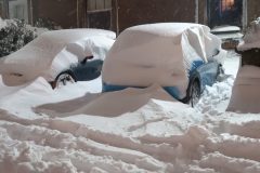
Over 3 feet of snow buried Providence, Rhode Island, breaking the daily and storm total snowfall records. Vehicles were buried, accidents were widespread, and students from Brown University, a famous university, went sledding and skied around campus.
All footage shot in/near Providence, Rhode Island, on February 23, 2026, by Meteorologist and Storm Chaser Simon Brewer.
Shot Description
00:00 Brown University student uses skis to travel around Providence
00:09 pedestrians walk and play in the snow
00:21 students from Brown University go sledding down city streets
00:32 pedestrians and deep snow in Providence
00:49 vehicles buried beneath feet of snow
01:50 State Capital Building with snow
02:06 front loader clears snow from the parking lot following recorded snowfall
02:50 deep snow in Providence
03:07 car accident with police
SID: Simon Brewer
#blizzard #bombcyclone #noreaster #RIWX #weather
To help support our freelancers, buy them coffee. https://www.buymeacoffee.com/stormchasing/
To License This Footage For Broadcast, Contact Video @ StormChasingVideo.com
Our Team Merch Store – https://stormchasingvideo.creator-spring.com
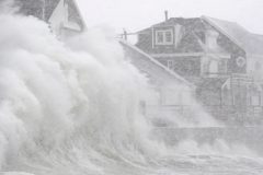
Massive damaging waves, storm surge, high damaging winds, white-out conditions, heavy snow with a powerful NorEaster in Scituate, Massachusetts.
All footage shot in/near Scituate, Massachusetts, on February 23, 2026, by Meteorologist and Storm Chaser Simon Brewer.
Shot Description
00:00 Massive waves hit the seawall and homes in Scituate
00:30 storm surge flooding in Scituate
00:57 high winds damage power lines
01:43 electronic highway signs warn of high winds and blizzard conditions
02:01 various shots of accidents and whiteout conditions on surrounding highways
SID: Simon Brewe
#noreaster #MAWX #StormSurge #naturaldisaster #blizzard
To help support our freelancers, buy them coffee. https://www.buymeacoffee.com/stormchasing/
To License This Footage For Broadcast, Contact Video @ StormChasingVideo.com
Our Team Merch Store – https://stormchasingvideo.creator-spring.com
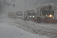
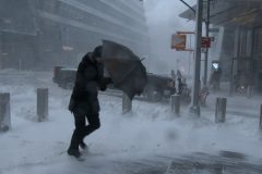
A powerful blizzard affected the entire Mid-Atlantic and Northeast coast on February 23 2026, with 1-2 feet of snow and hurricane-force winds. New York City experienced the full brunt of this storm, with several hours of blizzard and white out conditions.
Shot Description
SHOT 1: A line of NYC plow trucks clears the road.
SHOT 2 & 3: People fighting with umbrellas during the intense wind and blowing snow.
SHOT 4: A look up towards the top of a skyscraper disappearing into the wind & snow.
SHOT 5: Two people struggle to walk down the street against the strong winds and blowing snow.
SHOT 6: A person walks around the corner amid blowing snow.
SHOT 7: People crossing the street in blizzard conditions.
SHOT 8: People trying to shovel the sidewalk during blizzard conditions.
SHOT 9: Low-down shot of blowing snow creating a snow drift on a city street.
SHOT 10: Panning shot of swirling snow amidst tall buildings.
SHOT 11: Low-down shot of blowing snow creating a snow drift on a city street.
SHOT 12: A timelapse of snow piling up to over 15 inches deep.
SID: David Lewison
#blizzard #NYC #winterstorm #noreaster
To help support our freelancers, buy them coffee. https://www.buymeacoffee.com/stormchasing/
To License This Footage For Broadcast, Contact Video @ StormChasingVideo.com
Our Team Merch Store – https://stormchasingvideo.creator-spring.com
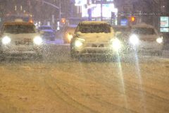
Intense blizzard conditions hit Hudson Yards and 10th Avenue in Manhattan as New York City experienced it's first blizzard in 9 years. Powerful winds made travel for both vehicles and pedestrians extremely difficult, if not impossible at times as whiteout conditions were common during the height of the storm
Shot Description
0:00- Pedestrians out and about navigating snow covered streets and whiteout conditions / FDNY responds to a manhole fire on 10th Avenue where flames were shooting several feet in the air.
0:41- Pedestrians and emergency vehicles navigate whiteout conditions and deep snow on 10th Avenue & 34th Street.
3:03- Commuters and pedestrians battle blizzard conditions at Hudson Yards (34th Street & 11th Avenue)
SID: Scott McPartland
#blizzard #nyc #newyork #weather
To help support our freelancers, buy them coffee. https://www.buymeacoffee.com/stormchasing/
To License This Footage For Broadcast, Contact Video @ StormChasingVideo.com
Our Team Merch Store – https://stormchasingvideo.creator-spring.com
Heavy snow and blizzard warning for Manhattan, New York City, New York, including Times Square, Radio City Music Hall, The Empire State Building, and trees snapping from the weight of heavy wet snow.
All footage shot during evening darkness on February 22, 2026, in Manhattan, New York City, New York by Meteorologist and Storm Chaser Simon Brewer.
Shot Description
00:00 snowplow and Radio City Music Hall
00:21 heavy snow falling on Times Square
00:47 heavy snow falling on the Empire State Building
01:10 heavy snow and the Guggenheim Museum
01:23 Subway sign and snow
01:32 tree branch snaps under weight of heavy wet snow
02:12 ambulance and heavy snow
02:20 people clearing snow off sidewalks
02:34 taxi cab and pedestrians in heavy snow
SID: Simon Brewer
#NYX #Blizzard #winterstorm #noreaster
To help support our freelancers, buy them coffee. https://www.buymeacoffee.com/stormchasing/
To License This Footage For Broadcast, Contact Video @ StormChasingVideo.com
Our Team Merch Store – https://stormchasingvideo.creator-spring.com