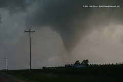
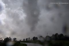
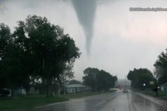
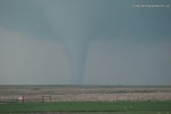
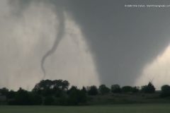
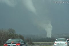
Powerful tornado southeast of Effingham, IL – Close range chase, June 17, 2026.
Shot Description
1. Rotating funnel near Bethany.
2. Tornado-warned storm near Charleston, IL.
3. Rain-wrapped tornado (Charleston, IL).
4. Approaching Effingham, IL tornado.
5. View of approaching tornado (Effingham, IL).
6. Stable shot of tornado approaching (2 shots).
7. Close-range pass of tornado (3 shots).
8. View of tornado moving ESE away (3 shots).
SID: CHRISTOPHER COLLURA
To help support our freelancers, buy them coffee. https://www.buymeacoffee.com/stormchasing/
To License This Footage For Broadcast, Contact Video @ StormChasingVideo.com
Our Team Merch Store – https://stormchasingvideo.creator-spring.com
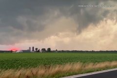
Video captured from the south side of Effingham, Illinois, Wednesday evening, June 17, 2026, between 8 and 8:30 PM, showing the tornado that resulted in a PDS tornado warning being issued for the city of Effingham, Illinois.
Shot Description
00:00 Video driving north toward the City of Effingham, Illinois, showing the initial stages of the tornado forming and just beginning to touchdown.
00:34 Video from the south side of the City of Effingham, Illinois, showing the tornado touching down and beginning to kick up debris.
00:48 You can hear a person in the background calling their Mom and showing them a live video of the tornado via FaceTime.
00:58 You can hear the mother ask, Where you guys at with the group replying, South of Effingham, that thing going through the city…thats debris.
01:10 You can see the tornado kicking up debris in the background, and the chasers watching and commenting on it in disbelief.
02:09 Video of the tornado now on the east side of the road and still on the ground, causing damage in the distance.
02:49 Video of the tornado being more defined as it kicks up more debris.
SID: Erin Kornfeind
To help support our freelancers, buy them coffee. https://www.buymeacoffee.com/stormchasing/
To License This Footage For Broadcast, Contact Video @ StormChasingVideo.com
Our Team Merch Store – https://stormchasingvideo.creator-spring.com
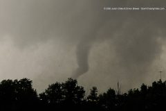
A damaging tornado with debris hits Effingham, Illinois, destroying homes.
All footage shot in/near Effingham, Illinois, on June 17, 2026 by Meteorologists and Storm Chasers Juston Drake and Simon Brewer
Shot Description
00:00 Tornado with debris doing damage in Effingham, Illinois
01:14 Dramatic lightning strike
01:21 Several large utility poles are down, blocking the road
01:52 Home destroyed by tornado
SID: Simon Brewer Juston Drake
To help support our freelancers, buy them coffee. https://www.buymeacoffee.com/stormchasing/
To License This Footage For Broadcast, Contact Video @ StormChasingVideo.com
Our Team Merch Store – https://stormchasingvideo.creator-spring.com
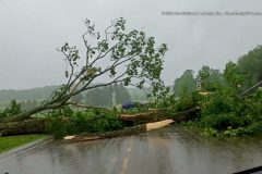
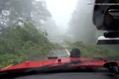
Video of severe storm damage near Saegertown, PA, following severe weather and a possible tornado in the area late Sunday afternoon. The video shows several large trees down across the road, blocking roadways and taking down power lines. As the storms rolled through, pea- to quarter-sized hail had also fallen. Online records from the Northwestern REC Outage Map report 119 active power outages affecting over 19,700 customers as of 8:30 PM.
Shot Description
00:00 Video of the leading edge of the severe storms working through the area with pea to quarter-sized hail falling.
00:14 Video of trees that have fallen and are partially blocking the road, with the local fire department on scene working to clear the fallen trees and directing traffic around the debris.
00:25 Several large tree branches are down, blocking the road, with power lines tangled in the trees and branches, as moderate to heavy rain continues to fall.
00:36 Two videos show large trees snapped at the base, completely blocking the road, and vehicles can be seen on the other side of the tree, turning around because the road is completely blocked. The storm chasers can be heard on the phone with 911 in the second clip, reporting the storm damage. Power lines can also be seen lying on the ground.
00:54 Another large branch or tree is down, blocking the roadway following the severe storms.
01:04 Clip showing a downed tree branch or part of a tree partially blocking the roadway.
01:18 Video panning up, showing large portions of a tree broken off and lying on power lines after the severe weather.
01:27 Video of good Samaritans stopping to help clear storm damage and debris out of the roadway following the severe storms.
01:43 Video showing a large tree or a large tree branch that had reportedly fallen on a shed following the severe weather.
01:54 Video showing heavy rain continuing to fall and a kiddy pool on the side of the road that likely got blown away by the strong winds from the severe storms.
SID: Noah Stainbrook Makayla King
To help support our freelancers, buy them coffee. https://www.buymeacoffee.com/stormchasing/
To License This Footage For Broadcast, Contact Video @ StormChasingVideo.com
Our Team Merch Store – https://stormchasingvideo.creator-spring.com
Dramatic footage from Ipava, IL, and Rantoul, IL, of Large power lines that snapped next to a vehicle, as the tornadic circulation was right overhead. You can see the extreme bright power flashes from a transformer, and a dramatic rope tornado over Illinois during a significant tornado outbreak.
All footage shot during evening daylight on June 11, 2026 in or near the towns of Ipava and Rantoul, Illinois by Meteorologists and Storm Chasers Juston Drake and Simon Brewer.
Shot Description
00:00 large power-lines snap next to storm chasers from high winds
00:16 multiple power flashes over the highway from the transformer
00:39 dramatic rope tornado
01:09 tornado crosses the road
01:55 squiggly rope tornado
02:49 large rotating wall cloud
02:55 dramatic lightning strike at sunset
SID: Simon Brewer Juston Drake
#Tornado #ilwx #ipava #illinois
To help support our freelancers, buy them coffee. https://www.buymeacoffee.com/stormchasing/
To License This Footage For Broadcast, Contact Video @ StormChasingVideo.com
Our Team Merch Store – https://stormchasingvideo.creator-spring.com
Close-range tornado in Daviess County, Missouri – June 10, 2026
Shot Description
1. 3 Shots of tornado approaching from SW.
2. Tornado passing close by, with rope-out directly overhead. Heavy rain-wrap.
3. Other chasers, a tornado just misses a farm and Homestead.
4. New developing tornado before rain-wrap west of Trenton, MO.
SID: CHRISTOPHER COLLURA
To help support our freelancers, buy them coffee. https://www.buymeacoffee.com/stormchasing/
To License This Footage For Broadcast, Contact Video @ StormChasingVideo.com
Our Team Merch Store – https://stormchasingvideo.creator-spring.com
Several tornadoes hit Northern Missouri including a large tornado near Unionville.
All footage shot during evening daylight on June 10, 2026 in/near Unionville, Missouri by Meteorologists and Storm Chasers Juston Drake and Simon Brewer.
Shot Description
00:00 Large tornado
00:39 tornado ropeout
00:47 dramatic wall cloud
00:56 multivortex tornado
SID: Simon Brewer Juston Drake
#MOWX #tornado
To help support our freelancers, buy them coffee. https://www.buymeacoffee.com/stormchasing/
To License This Footage For Broadcast, Contact Video @ StormChasingVideo.com
Our Team Merch Store – https://stormchasingvideo.creator-spring.com
Just before 3 AM on June 10, 2026, a line of strong to severe storms worked through the Twin Cities metro. The NWS Twin Cities issued a Special Weather Statement around 2:30 AM, which encompassed the Twin Cities metro into Dakota County, including the City of Apple Valley, for wind gusts of 40 mph and pea-sized hail. By 3 AM, the NWS Twin Cities issued an updated weather post as the line was entering the Apple Valley, MN, area, noting that it was moving northeast and producing wind gusts of 40-50 mph. Around 3:20 AM, Apple Valley Fire was dispatched to the 13000 block of Glenhaven Avenue in Apple Valley for reports of a collapsed structure. Fire crews arrived to find a large tree had fallen onto the home. It is unknown at this time the extent of the damage or if there were any injuries, but crews were on scene Wednesday morning working to remove the large oak tree. We spoke with a worker of the tree removal company, who stated that almost the entire canopy of the large oak tree was taken down and fell through the roof and into the second floor of the home.
Shot Description
00:00 Wide and medium shots showing tree removal and remediation crews working to cut up and remove portions of the oak tree from the large hole in the roof of the home.
00:27 Various close, medium, and wide shots showing crews removing sections of tree from the roof and second floor of the home; the collapsed roof is clearly visible.
01:12 Various shots showing workers on the roof of the home with the large hole in the roof and the second floor visible. Workers can be seen surveying the damage.
01:44 Video showing where the large sections of the oak tree canopy came from in the healthy oak tree that was blown over in the strong wind gusts onto the home.
01:50 Additional video showing crews driving the cherry picker toward the opening in the roof from the fallen tree.
01:58 Various shots of crews from the tree removal company cutting up and removing branches from the large oak tree that fell on the home.
02:13 Video of a worker loading the tree branches into the tree removal truck with a grapple.
02:40 Close and medium shots showing where the large sections of the oak tree broke off and later fell onto the home.
02:56 Close and medium shots showing crews continuing to cut a part and remove the large oak tree.
03:10 Close-up of the large section of oak tree that broke off and fell on the home.
03:18 Close-up to panning out to a medium shot of a worker standing under a section of the home damaged after the tree fell on it.
03:26 Medium and wide shots showing workers continuing to remove the large oak tree and also showing the overall size of the large section of oak tree that fell.
03:47 Video showing a street sign of the nearest intersection to where this occurred.
03:56 Close shot of a sign showing "Tree Work Ahead" with the tree removal crews in the background.
SID: Limitless Media
To help support our freelancers, buy them coffee. https://www.buymeacoffee.com/stormchasing/
To License This Footage For Broadcast, Contact Video @ StormChasingVideo.com
Our Team Merch Store – https://stormchasingvideo.creator-spring.com
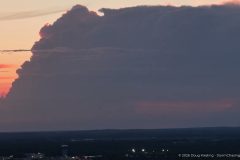
Time-lapsed drone footage of a severe warned thunderstorm from 40 miles away. The severe storm was near Alexandria, MN, while it was filmed near Saint Cloud, MN, at sunset on 6/8/2026.
To help support our freelancers, buy them coffee. https://www.buymeacoffee.com/stormchasing/
To License This Footage For Broadcast, Contact Video @ StormChasingVideo.com
Our Team Merch Store – https://stormchasingvideo.creator-spring.com
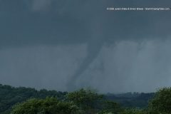
Cone tornado near Madison, Kansas
All footage shot during evening darkness on May 31, 2026, near Madison, Kansas by Meteorologists and Storm Chasers Juston Drake and Simon Brewer
Shot Description
00:00 cone tornado illuminated by lightning near Madison, Kansas
00:40 close lightning strike in front of a cone funnel cloud
SID: Simon Brewer Juston Drake
To help support our freelancers, buy them coffee. https://www.buymeacoffee.com/stormchasing/
To License This Footage For Broadcast, Contact Video @ StormChasingVideo.com
Our Team Merch Store – https://stormchasingvideo.creator-spring.com
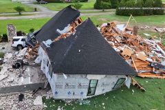
Footage from the drone of the Tornado damage in Henry County, Alabama
Shot Description
Multiple clips from a drone covering the first light damage of the Tornado that ripped through Houston and Henry County in Alabama on May 25, 2026.
SID: Michael Gordon
#aftermath #drone #tornado #alabama
To help support our freelancers, buy them coffee. https://www.buymeacoffee.com/stormchasing/
To License This Footage For Broadcast, Contact Video @ StormChasingVideo.com
Our Team Merch Store – https://stormchasingvideo.creator-spring.com
Tornado on the Ground near Dothan, AL, and after dark aftermath footage.
Shot Description
00:00 Seven clips showing the tornado as it made its way near Dothan, doing damage in Webb, AL.
02:10 Two clips showing some of the minor damage.
SID: Michael Gordon
#ALWX #tornado
To help support our freelancers, buy them coffee. https://www.buymeacoffee.com/stormchasing/
To License This Footage For Broadcast, Contact Video @ StormChasingVideo.com
Our Team Merch Store – https://stormchasingvideo.creator-spring.com
Footage of the landspout tornado that briefly touched down and the extreme oil fire after lightning struck an oil pumping jack and storage tanks.
Shot Description
1. Landspout (dust swirl under base).
2. Oil battery fire scene 1.
3. Fire scene 2.
SID: CHRISTOPHER COLLURA
#TXWX #landspout #tornado #fire
To help support our freelancers, buy them coffee. https://www.buymeacoffee.com/stormchasing/
To License This Footage For Broadcast, Contact Video @ StormChasingVideo.com
Our Team Merch Store – https://stormchasingvideo.creator-spring.com
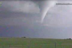
A cone tornado moves over the outskirts of Blue Rapids, Kansas.
All footage shot during evening daylight on May 18, 2026, in/near Blue Rapids, Kansas by Meteorologists and Storm Chasers Juston Drake and Simon Brewer
Shot Description
00:00 A large cone tornado as we drove through the town of Blue Rapids, Kansas.
SID: Simon Brewer Juston Drake
#tornado #KSWX #stormchasing #stormchas
To help support our freelancers, buy them coffee. https://www.buymeacoffee.com/stormchasing/
To License This Footage For Broadcast, Contact Video @ StormChasingVideo.com
Our Team Merch Store – https://stormchasingvideo.creator-spring.com
Footage of the tornado that touched down near Saint Libory, Nebraska,, today, 5/17/2026
Shot Description: One long clip of the tornado that touched down near Saint Libory, Nebraska, from about a mile away. Shot POV style.
SID: Jesse Risley
#Tornado #NEWX #weather #storm
To help support our freelancers, buy them coffee. https://www.buymeacoffee.com/stormchasing/
To License This Footage For Broadcast, Contact Video @ StormChasingVideo.com
Our Team Merch Store – https://stormchasingvideo.creator-spring.com
New footage of the High Precipitation or HP Super-Cell thunderstorm with a large, violent tornado, wrapped in rain at close range, along with aftermath footage in Mississippi.
Shot Description
1. View of a weak possible tornado over Natchez, MS.
2. Shots near the bridge clearing, looking north from Garden City, MS (3 shots).
3. RFD and approaching passing tornado between Garden City and Roxie.
4. Strong winds and tree debris/roadway blocked (2 shots).
5. Tornado path on I-55 south of Brookhaven, MS at dusk.
SID: CHRISTOPHER COLLURA
#tornado #Mississippi #weather #aftermath
To help support our freelancers, buy them coffee. https://www.buymeacoffee.com/stormchasing/
To License This Footage For Broadcast, Contact Video @ StormChasingVideo.com
Our Team Merch Store – https://stormchasingvideo.creator-spring.com
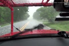
Raw Video from a motorist who was caught in the rain-wrapped tornado that hit Mineral Wells, Texas. The rain-wrapped tornado was near Highway 180, and large debris was raining down on top of them as they tried to escape the area.
#Tornado #Texas #mineralwells #stormchasers
To help support our freelancers, buy them coffee. https://www.buymeacoffee.com/stormchasing/
To License This Footage For Broadcast, Contact Video @ StormChasingVideo.com
Our Team Merch Store – https://stormchasingvideo.creator-spring.com
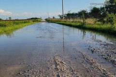
Video captured in Mexico and Centralia, Missouri, located in Central Missouri, showing flooding across Audrain County after they received around 1.96 inches of rain since 7 am today and around 2.66 inches between midnight Monday and 5 pm, in about 17 hours. The heavy rain and flooding prompted a flash flood warning from the National Weather Service in St. Louis, issued around 11:48 AM and lasting until 2:45 PM after 1-2 inches of rain had fallen.
Shot Description
00:00 Close and medium shots showing heavy rain falling on the front of a vehicle on Monday afternoon in Centralia, Missouri.
00:30 Close-up shot of ponding water forming as heavy rain continues to fall, with the next clip showing a wide shot of a ditch completely flooded and beginning to overflow as heavy rain is actively falling.
00:52 Sign on the side of the road saying the road is impassable during high water.
01:03 A wide and medium shot of signs in the ditch used to measure how deep the flood waters are on the roadways. In the videos, you can see flash flooding in the ditches just short of where the measurement signs begin.
01:24 Two clips of a vehicle driving through flood waters on the roadway.
01:53 Three clips of high water flowing under the roadway with caution tape and cones marking the edge of the road or ditch following the heavy rains.
02:11 Various clips showing the fast-moving flood waters along the side of the road and through a fence.
02:49 Video showing a partially flooded pasture with cows standing along the edge of the flood waters.
02:57 Video of a golden retriever walking through the flood waters of a river or stream that flooded over its banks, and up to the edge of the fast-moving flood waters.
03:11 In this clip, the same golden can be seen running away from the fast-moving flood waters and playing in the water.
03:19 Various medium and wide shots showing a flooded roadway and water flowing across the road following the heavy rains.
03:50 Additional wide and medium shots showing the fast-moving and flooded ditches from the heavy rains.
04:13 Video of a neighbor driving an ATV through the flooded roadway following the heavy rains, after they had checked out the flooding.
04:21 Additional clips showing a completely flooded roadway flowing over the road.
05:13 Video of a guy walking out into a flooded farm field. Based on the boots the man was wearing, the water was roughly 15-18" deep in spots.
05:39 Wide shots showing the farm field completely flooded following the heavy rains.
06:04 Two more clips showing water flowing across a roadway following the heavy rains.
06:20 The final three clips are medium and close-up shots of a rain gauge just before a measurement was taken around 5 PM, showing around 1.96 inches of rain since 7 am Monday morning.
SID: Sara Bruce
#MOWX #FlashFlooding #flooding
To help support our freelancers, buy them coffee. https://www.buymeacoffee.com/stormchasing/
To License This Footage For Broadcast, Contact Video @ StormChasingVideo.com
Our Team Merch Store – https://stormchasingvideo.creator-spring.com
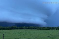
Video of the Twin tornadoes near Shidler, Oklahoma that touched down Sunday Night.
Shot Description
1. First tornado forms (several tight and wide shots).
2. Funnel.
3. Twin tornadoes (3 shots).
4. Panning view of supercell storm flanking line.
5. Driving with funnel and front of vehicle.
6. Supercell low level meso.
SID: CHRISTOPHER COLLURA
#okwx #tornado #tornadoes #stormchasers
To help support our freelancers, buy them coffee. https://www.buymeacoffee.com/stormchasing/
To License This Footage For Broadcast, Contact Video @ StormChasingVideo.com
Our Team Merch Store – https://stormchasingvideo.creator-spring.com
Severe supercell storms with large hail in Garvin and Johnston County, Oklahoma.
Shot Description
1. Video ID slug.
2. Shot of laptop and start of hail near Pauls Valley.
3. Supercell wall cloud.
4. Small to moderate hail in grass.
5. View of RFD and wall cloud area looking north.
6. Shots of very large hail near Wapanucka (3 shots).
SID: CHRISTOPHER COLLURA
#stormchasers #okwx #supercell #hailstorm #hailstorm
To help support our freelancers, buy them coffee. https://www.buymeacoffee.com/stormchasing/
To License This Footage For Broadcast, Contact Video @ StormChasingVideo.com
Our Team Merch Store – https://stormchasingvideo.creator-spring.com
Chase video of the Bramen, Oklahoma, Kay County tornadic supercell and evolution into the vivid tornado.
#okwx #tornado #supercell #stormchasers
To help support our freelancers, buy them coffee. https://www.buymeacoffee.com/stormchasing/
To License This Footage For Broadcast, Contact Video @ StormChasingVideo.com
Our Team Merch Store – https://stormchasingvideo.creator-spring.com
Footage of a tornado on the Southeast side of Rochester, Minn., that ripped the roofs off homes and did significant damage to the area.
Shot Description
0:00 – Tornado going over hillsides of Rochester, Minnesota, causing damage to houses and trees.
1:05 – Tornado damage of multiple houses with roofs torn off and partial second levels of homes, as well as a lot of downed trees and debris.
SID: Jarrod Schoenecker
#tornado #MNWX #stormchasing #stormdamage
To help support our freelancers, buy them coffee. https://www.buymeacoffee.com/stormchasing/
To License This Footage For Broadcast, Contact Video @ StormChasingVideo.com
Our Team Merch Store – https://stormchasingvideo.creator-spring.com
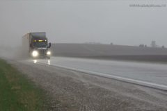
Morning severe 1 inch plus hail in rural Le Sueur County west of Kilkenny, Minn.
Shot List:
0:00 – 1 inch plus hail bouncing off of bare field and grass
0:25 – 1 inch plus hail falling and a semi-truck driving by
SID: Jarrod Schoenecker
To help support our freelancers, buy them coffee. https://www.buymeacoffee.com/stormchasing/
To License This Footage For Broadcast, Contact Video @ StormChasingVideo.com
Our Team Merch Store – https://stormchasingvideo.creator-spring.com