A vessel that sunk after a fatal collision with the Fisher Island ferry blocks cruise ships from entering the Port of Miami Florida for over 10 hours on Sunday. Three massive cruise ships carrying thousands of passengers each and two container ships were denied entry until salvage crews could locate and remove the sunken vessel from the Government Cut near buoy 18. The salvage crews were further impeded by heavy thunderstorms but eventually cleared the channel so ships could enter by mid afternoon, 10 hours behind schedule. No audio.
Shot Description
00:00 Empty cruise terminals at Port Miami on Sunday morning. Very rare sight as Sunday is the busiest day of the week for cruise ships to exchange passengers at the port.
00:08 Four scenes of cruise ships lurking offshore Miami waiting for permission to enter Port.
00:45 Three shots of crane barge positioned in Government Cut attempting to recover sunken vessel.
01:06 Four shots of heavy rain from thunderstorms hitting the Port of Miami impeding the salvage operation.
01:38 Crane barge unloading recovered sunken vessel at the Miami Beach Coast Guard base.
01:59 Six shots of cruise ships finally entering the Port of Miami to exchange passengers after being delayed by 10 hours.
SID: Brian Dombrowski
#portofmiami #miami #cruiseships #cruiseship #cruiseshipvlog #florida
To help support our freelancers, buy them coffee. https://www.buymeacoffee.com/stormchasing/
To License This Footage For Broadcast, Contact Video @ StormChasingVideo.com
Our Team Merch Store – https://stormchasingvideo.creator-spring.com
A recreation vessel collides with the Fisher Island ferry at Government Cut at the Port of Miami Florida. The recreational vessel immediately sunk leaving one dead, one critically injured, and blocking cruise and container ship traffic for 10 hours on Sunday. Video from Port of Miami camera syncs with VHF marine radio channel 16 and highlights key segments from 3am-4am span of time into 5 minutes of video and audio.
Shot Description
00:00 Camera angle 1 of the Fisher Island and Port Of Miami crash that shows the crash as it happened. The two Ferry’s pass by each fully lighted and can be seen for miles away while the recreational vessel is traveling at a high rate of speed at night and crashes into the Ferry.
00:41 Point of Impact, HUGE splash washes up over the Ferry as it then stops as the recreational boat moves off to the left and in front of the Ferry before sinking.
01:39 Mayday issued from Fisher Island ferry. Ferry in far distance in the Government Cut where the main channel meets the jetty.
With US Coast Guard replies to mayday.
Captain of ferry reports position.
Captain of 2nd ferry on scene reports seeing debris.
US Coast Guard and ferry captain converse on visual ID.
02:59 Emergency boat responds on camera with lights flashing.
2nd ferry captain ask if more than one accident victim and reply is only one known.
03:35 Tighter zoom on scene in Government Cut.
04:35 US Coast guard questions number of accident victims in water still.
05:08 Fireboat captain announces transport of first victim.
06:17 Fireboat announces confirmation of a 2nd victim missing in water (later found deceased.)
06:35 US Coast guard announces closure of channel and Government Cut to search for 2nd victim.
SID: Brian Dombrowski
#PortOfMiami #GovernmentCut #boating #florida #miami #accident
To help support our freelancers, buy them coffee. https://www.buymeacoffee.com/stormchasing/
To License This Footage For Broadcast, Contact Video @ StormChasingVideo.com
Our Team Merch Store – https://stormchasingvideo.creator-spring.com
To help support our freelancers, buy them coffee. https://www.buymeacoffee.com/stormchasing/
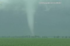
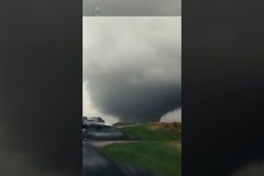
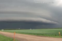
Tornadic Outbreak in Minnesota, Multiple tornadoes touch down in northwestern Minnesota.
*** Fargo DMA (WDAZ, WDAY, KVRR) NO USE IN FARGO DMA ***
Shot Description
00:00 – Tornado near Lockhart, MN
00:36 – Closer shot of the Lockhart, MN Tornado
01:27 – Two tornadoes (sisters), on the ground at the same time Near Beltrami, MN
SID: ERIC WHITEHILL
#MNWX #tornado #tornadoes
#tornadooutbreak
To License This Footage For Broadcast, Contact Video @ StormChasingVideo.com
Our Team Merch Store – https://stormchasingvideo.creator-spring.com
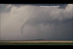
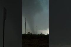
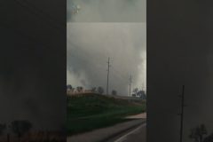
Multiple tornadoes along the Nebraska and Wyoming boarder region. Tornadoes 1 and 2 are in the Hawk Springs Wyoming area, both looking north from highway 88 and the third one was shot near Gering, NE viewed looking west on highway 92.
Shot Description
00:00 Raw footage of a Tornado near Hawk Springs, Wyoming.
02:39 Another tornado near Hawk Springs, Wyoming.
03:23 Tornado near Gering, Nebraska which is near Scottsbluff, Nebraska.
SID: Nathan Moore
#NEWX #tornado #WYWX #weather #stormchasing
To help support our freelancers, buy them coffee. https://www.buymeacoffee.com/stormchasing/
To License This Footage For Broadcast, Contact Video @ StormChasingVideo.com
Our Team Merch Store – https://stormchasingvideo.creator-spring.com
Raw footage of two tornadoes that dropped down near Chugwater and Slater, Wyoming.
Shot Description
00:00 First tornado touches down while driving on Highway 313 as the tornado forms over open country.
00:24 Second tornado forms over an open field.
02:05 Repositioning to keep a clean shot as the tornado continues to touch down over an open field.
04:03 Tornado moves off and starts to become obscured by rain.
SID: Nathan Moore
#tornado #weather #wyoming #WYWX #tornadooutbreak
To help support our freelancers, buy them coffee. https://www.buymeacoffee.com/stormchasing/
To License This Footage For Broadcast, Contact Video @ StormChasingVideo.com
Our Team Merch Store – https://stormchasingvideo.creator-spring.com
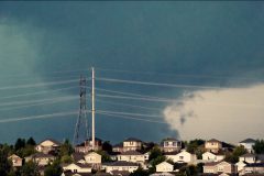
Footage of the Highlands Ranch tornado from looking due west from Parker Colorado near E470
Shot Description
00:00 – Large tornado fills the screen with power-lines and homes in the foreground to give perspective and depth of field.
00:49 – Camera looks around to show the scene where there was hail cores in different areas while photog was talking to his forecaster.
01:16 – Long shot of the large tornado passing behind a high tension power line and group of homes.
05:25 – Rain Wrapped tornado in the distance and lightning on the right side of the screen.
SID: Nathan Moore
To help support our freelancers, buy them coffee. https://www.buymeacoffee.com/stormchasing/
To License This Footage For Broadcast, Contact Video @ StormChasingVideo.com
Our Team Merch Store – https://stormchasingvideo.creator-spring.com
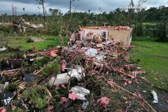
Horrific Tornado Damage at First Light captured from Drone in Louin, Mississippi
Shot Description
00:00 (4 Clips) Chicken Houses completely wiped off the map from horrific tornado
00:30 Low Flying pass with many homes destroyed from Tornado
01:25 Trees chopped off 5-10ft above ground
01:47 Home destroyed with vehicles crushed from trees
02:04 High up view of multiple homes completely leveled from tornado
02:20 Roof is completely gone off home and you can look down inside
02:28 Trees snapped and uprooted with homes demolished and debris scattered
03:26 Trees chopped off from tornado 5′ above ground
Multiple clips showing the devastation from the tornado that destroyed a community in Louin, Mississippi. It shows horrific damage.
03:57 Fly over of the extensive damage
04:53 Destroyed home with debris all over the place
05:07 Ground footage
05:38 Drone footage of the damage
06:13 Fly through tree stumps where the tornado snapped off the trees
06:36 More drone footage of the chicken farm destruction
SID: Michael Gordon
#Mississippi #Louin #MSWX #tornado #drone #aftermath
To help support our freelancers, buy them coffee. https://www.buymeacoffee.com/stormchasing/
To License This Footage For Broadcast, Contact Video @ StormChasingVideo.com
Our Team Merch Store – https://stormchasingvideo.creator-spring.com
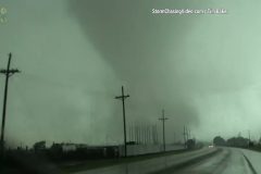
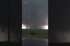
Full raw 4K footage catalog of the Perryton, Texas tornado from Tim Baker, AKA Tornado Tim.
00:00 – The footage starts just outside of the town of Perryton, Texas as wall cloud with rapid rotation forms into a tornado.
03:00 – Tornado touches down as they continue to drive towards the storm as it enters Perryton, Texas.
04:43 – The Tornado crosses the road right in front of them while throwing debris into the air.
07:23 – The tornado leaves Perryton but the hail storm starts to hit the area and their vehicle.
07:49 – Taking cover from the hail storm.
08:35 – Now they continue to follow the tornado that has now formed a second tornado next to it.
11:38- Outside of the town of Perryton, Texas, the two tornadoes become one tornado again and they follow the storm south on Highway 83.
20:13 – As the storm begins to fade away and the tornado weakens to a rope out stage, they pull over to watch the final part of the tornado before ending the chase to go back to Perryton and help with search and rescue.
To help support our freelancers, buy them coffee. https://www.buymeacoffee.com/stormchasing/
To License This Footage For Broadcast, Contact Video @ StormChasingVideo.com
Our Team Merch Store – https://stormchasingvideo.creator-spring.com
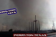
Raw footage of the huge tornado hitting Perryton, Texas today. Footage shot on Highway 15 from the east side of Perryton as the tornado made a direct hit on the town.
Shot Description
Raw footage of the Perryton, Texas taking a direct hit from the large tornado this afternoon 6/15/2023
SID: Tim Baker
#perryton #Texas #tornado #stormchasing #TXWX
To help support our freelancers, buy them coffee. https://www.buymeacoffee.com/stormchasing/
To License This Footage For Broadcast, Contact Video @ StormChasingVideo.com
Our Team Merch Store – https://stormchasingvideo.creator-spring.com
Back in June of 2003, College Students, Jim Bishop and Reed Timmer (Stormgasm.com) drove up to South Dakota to chase this historic epic Tornado, the Manchester, South Dakota Tornado.
6/24/2003 Jim Bishiop and Reed Timmer
Storm Chasers captured an Incredible and Phenomenal Tornado in Fort Stockton, Texas on June 2nd, 2023.
#tornado #fortstockton #texastornado #stormchasing #trendingshorts #viralshorts
To help support our freelancers, buy them coffee. https://www.buymeacoffee.com/stormchasing/
To License This Footage For Broadcast, Contact Video @ StormChasingVideo.com
Our Team Merch Store – https://stormchasingvideo.creator-spring.com
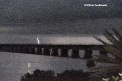
Heavy overnight thunderstorms in the Florida Keys near the Seven Mile Bridge prompted the NWS Key West to issue a special marine warning late Tuesday night. Video shows frequent cloud to surface lightning strikes over the history Seven Mile Bridge, Pigeon Key, and Marathon FL. Audio is NWS Key West Wx radio.
Shot Description
00:00 A plane flies over the community of Marathon Florida as lightning illuminates the clouds.
00:14 Wide shot of old Seven Mile Bridge on right and new Seven Mile Bridge on left as cloud to surface lightning strikes.
00:20 Thirteen cloud to surface lightning strikes over old historic Seven Mile Bridge from Pigeon Key Florida.
01:25 Lightning offshore Marathon FL.
01:34 Lightning flashes as boat moves offshore.
SID: Brian Dombrowski
#floridakeys #lightning #stormchasing #weather
To help support our freelancers, buy them coffee. https://www.buymeacoffee.com/stormchasing/
To License This Footage For Broadcast, Contact Video @ StormChasingVideo.com
Our Team Merch Store – https://stormchasingvideo.creator-spring.com
Reports from trained spotters, social media and the weather observer at the Miami Executive Airport of a funnel cloud in the Redland West of South Miami Heights.
Funnel clouds & heavy thunderstorms with lightning developed near Miami International Airport (KMIA) before 2pm on Thursday afternoon. Airplanes on final approach and landing with funnel clouds, thunderstorms and lightning. Audio is KMIA arrival ATIS and KMIA north tower ATC. Funnel clouds were confirmed with NWS special weather statements at 1:53pm EDT.
Shot Description
00:00 Funnel cloud NW of Miami International Airport (KMIA)
01:58 Funnel cloud NW of KMIA tight
02:15 Funnel cloud NW of KMIA wide
02:39 Funnel cloud NW of KMIA med
02:51 Funnel cloud over runway of KMIA as airplane lands
03:09 Funnel cloud over runway of KMIA as airplane lands
03:21 Cloud to ground lightning as airplane lands at KMIA
03:35 American Airlines airplane lands with ominous clouds and rain moving in.
03:46 Spirit Airlines airplane lands with ominous clouds and rain moving in.
04:01 Airplane on final approach with storm clouds.
04:12 Airplane on final approach with storm and rain foot in background.
04:27 Rain foot and developing funnel cloud behind KMIA.
04:54 Heavy rain over runway and control tower at KMIA.
05:02 Time-lapse clip of storm and rain moving over KMIA.
05:11 Storm clouds towering NW of KMIA.
05:18 GC lightning strikes NW of KMIA.
05:27 Another GC lightning strike NW of KMIA.
05:33 Cumulonimbus building east now over Atlantic Ocean behind Miami skyline.
SID: Brian Dombrowski
#miami #FLWX #Funnelcloud #tornado #waterspout #florida
To help support our freelancers, buy them coffee. https://www.buymeacoffee.com/stormchasing/
To License This Footage For Broadcast, Contact Video @ StormChasingVideo.com
Our Team Merch Store – https://stormchasingvideo.creator-spring.com
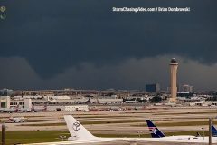
Video of airplanes flying, taking off and landing in heavy thunderstorms, rain and lightning at Miami International Airport (KMIA.) Multiple CG lightning strikes in frame with flying aircraft. Planes backed up for take-off on ground stop. Remote camera video. No audio.
Shot Description
00:00 Plane on final approach to land with cumulonimbus clouds in background at Miami International Airport.
00:14 Two shots on aircraft waiting to take-off.
00:44 Wide shot of nine aircraft waiting to take off with storm clouds in background.
00:52 Southwest Airlines plane lands.
01:03 Two shots of planes taking off with lowering or possible funnel cloud in background.
01:31 Plane landing with two cloud to ground (CG) lightning strikes behind it.
01:49 Plane taking off and another plane landing as rain move in reducing visibility.
02:27 Plane in distance after taking off among storm clouds.
02:35 Plane lands with lightning flash.
02:49 CG lightning strike behind runway just after plane lands.
03:10 Lightning flashes in clouds behind airport.
03:14 Plane landing as lightning flashes.
03:30 Eleven aircraft backed up on ground stop waiting to take off.
03:39 Ominous clouds behind airport.
03:47 CG lightning behind American Airlines hangar.
03:55 Lightning flash
03:59 Plane lands as lighting flashes behind AA hangar.
04:08 Plane lands with lightning flash.
04:24 Heavy rain moves over airport as airplane lands.
04:41 Tighter shot of control tower with three American Airlines planes waiting to take off.
04:49 Three shots of aircraft waiting to take off in rain.
05:17 Lighting flash illuminates orange and purple sky behind airport.
05:21 American Airlines hangar in rain.
SID: Brian Dombrowski
#MIA #miami #weather #tornado #stormchasing
To help support our freelancers, buy them coffee. https://www.buymeacoffee.com/stormchasing/
To License This Footage For Broadcast, Contact Video @ StormChasingVideo.com
Our Team Merch Store – https://stormchasingvideo.creator-spring.com
Insane Tornadoes caught on camera in Rozel Kansas on May 18, 2013. Simon Brewer and Juston Drake with the Storm Riders caught on film extreme tornadoes.
#insane #tornadoes #rozel #maytornadoes #Kansas #viralshorts #shorts #trendingshorts
To help support our freelancers, buy them coffee. https://www.buymeacoffee.com/stormchasing/
To License This Footage For Broadcast, Contact Video @ StormChasingVideo.com
Our Team Merch Store – https://stormchasingvideo.creator-spring.com
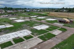
Drone Survey Two Months after Deadly Tornado Ravages Rolling Fork, Mississippi leaving empty lots and piles of debris. The town was dead except for a few residents that are still living there. Reminded me of a Ghost Town.
Shot Description
00:00 Flying over the Rolling Fork water tower with homes gone from their foundations and tarps covering homes
00:05 Overhead view in the center of Rolling Fork, MS showing only foundations of homes that were once there
00:21 Still shot looking North East showing the damage path from the deadly tornado
00:30 Flyby scene showing a building completely demolished with brick door way left standing with the collapsed Rolling Fork water tower in the background
00:44 Homes removed and cleaned up from their foundations and tarps covering what is left of some homes that were destroyed
00:58 Overhead scene showing piles of cleaned up debris still left to be picked up with foundations of homes showing
01:14 Tornado Path rising above Rolling Fork, MS from the South West corner of the town where the tornado began destroying everything in its path
01:27 Panning shot showing what is left after two months of cleanup after the deadly EF-4 Tornado
01:41 Center of the town of Rolling Fork, MS with businesses demolished and roads barricaded
01:55 Contractors working on replacing a roof on a home that was destroyed by the tornado
02:17 Still shot showing debris still scattered and in piles of what is left two months after the destructive tornado
02:24 Scene looking south west through the town of Rolling Fork
02:32 Flying low over debris scattered and cleaned up foundations swept clean from the massive Tornado in Rolling Fork, MS
02:44 Rolling Fork residents digging through the dirt and looking for anything left from the Tornado
02:56 Overhead view showing nothing left from the Tornado but foundations that were swept clean from Tornado
03:39 Still scene looking south west showing the devastating path the Tornado made through Rolling Fork, MS
03:47 Still scene looking north east of what is left after the Rolling Fork Tornado destroyed the town
03:56 Low flyover of the north east part of Rolling Fork showing debris scattered and in piles with foundation swept clean
04:42 Vehicle Boneyard of vehicles that were demolished and totaled from the monster Rolling Fork Tornado
04:51 Flyover moving south west of the town of Rolling Fork, Mississippi
05:32 Still scene looking over the demolished Rolling Fork Water Tower
05:40 Scene showing only foundations left with a few piles of debris
05:54 Complete flight flying over Rolling Fork, MS showing the complete path and what is left of the city.
SID: Michael Gordon
#tornado #mississippi #rollingfork #weather #drone
To help support our freelancers, buy them coffee. https://www.buymeacoffee.com/stormchasing/
To License This Footage For Broadcast, Contact Video @ StormChasingVideo.com
Our Team Merch Store – https://stormchasingvideo.creator-spring.com
Epic Wedge Tornado Close Call with Cars and Violent Motion – Nebraska May 12th 2023
Spalding, Nebraska
Simon Brewer and Juston Drake
#shorts #stormchasing #nebraska #tornado #tornadowarning #stormchasing #epic #may #2023
To help support our freelancers, buy them coffee. https://www.buymeacoffee.com/stormchasing/
To License This Footage For Broadcast, Contact Video @ StormChasingVideo.com
Our Team Merch Store – https://stormchasingvideo.creator-spring.com
Dangerous Tornado Almost Hits Farm House in Nebraska – May 12th 2023
Bartlett, NE
Simon Brewer and Juston Drake
#shorts #tornado #warning #dangerous #spring #weather #may #2023 #nebraska #stormchasing
To help support our freelancers, buy them coffee. https://www.buymeacoffee.com/stormchasing/
To License This Footage For Broadcast, Contact Video @ StormChasingVideo.com
Our Team Merch Store – https://stormchasingvideo.creator-spring.com
Meteorologist and #Stormchaser Simon Brewer and Juston Drake are out in East Central Nebraska near the city of Columbus and Streaming #Live as the Tornado Watch just 215 just went into effect.
This powerful #weather system will impact several parts of eastern Nebraska.The National Weather Service has issued a #Tornadowatch Number 215 as storms are already showing up on radar. Be prepared and watch out for the warning’s.
DONT FORGET TO SUBSCRIBE AND LIKE THE VIDEO. MUCH APPRECIATED FROM SCV!!!
To help support our freelancers, https://www.buymeacoffee.com/stormchasingTo License This Footage For Broadcast, Contact Video @ StormChasingVideo.comSUBSCRIBE –
https://www.youtube.com/channel/UCWAN-rRJFLosqgiiIFVpkEQ?sub_confirmation=1SID: Simon BrewerTo License
This Footage For Broadcast, Contact Video @ StormChasingVideo.com #irl #tornado #nebraska #stormchasing #stormriders
To help support our freelancers, buy them coffee. https://www.buymeacoffee.com/stormchasing/
To License This Footage For Broadcast, Contact Video @ StormChasingVideo.com
Our Team Merch Store – https://stormchasingvideo.creator-spring.com
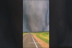
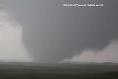
Close range intercept of a large wedge tornado west of Spalding, NE.
Shot Description
00:00 – Wedge tornado forms to our SW crossing open fields,
00:33 – Large tornado on the ground.
02:45 – The tornado eventually crossing directly in front of us and going to our NW. Approximately 7 miles west of Spalding, NE.
SID: Adriana Mozeris
#NEWX #Tornado #Nebrask #WedgeTornado
To help support our freelancers, buy them coffee. https://www.buymeacoffee.com/stormchasing/
To License This Footage For Broadcast, Contact Video @ StormChasingVideo.com
Our Team Merch Store – https://stormchasingvideo.creator-spring.com
Crazy Baseball Size Hail! May storms pound Missouri
Bancroft, MO
5/6/23
SID: Noah Stainbrook
#hailstorm #tornado #stormchasing #hail #weather #may #2023
To help support our freelancers, buy them coffee. https://www.buymeacoffee.com/stormchasing/
To License This Footage For Broadcast, Contact Video @ StormChasingVideo.com
Our Team Merch Store – https://stormchasingvideo.creator-spring.com
Supercell storm and wind-driven hail near Reno County, Kansas
Shot Description
1. Panning shot of HP supercell and RFD shelf cloud.
2. Shot of leading edge of mesocyclone while driving east.
3. Another panning shot of shelf cloud.
4. Hail storm and 75+ MPH winds slams Turon, Kansas.
5. Hail covering ground in Turon.
6. Shot of silos as hail eases a bit.
7. Flash flooding in Pratt, Kansas.
8. Hail along side of road near Pratt.
SID: CHRISTOPHER COLLURA
To help support our freelancers, buy them coffee. https://www.buymeacoffee.com/stormchasing/
To License This Footage For Broadcast, Contact Video @ StormChasingVideo.com
Our Team Merch Store – https://stormchasingvideo.creator-spring.com
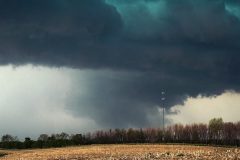
Severe storms with extreme winds and lowering with brief funnel cloud near Grinnell, Iowa.
Footage starts out with a rotating wall cloud almost on the ground and then a small funnel forming. During a storm merger, extreme inflow winds kicked up debris into the next mesocyclone and bell shaped lowering.
Shot Description
00:00 – Driving under a low base and developing wall cloud.
00:08 – Rotating Wall cloud almost on the ground and a funnel.
00:48 – Extreme winds and crop debris flying due to the storm in-flow winds.
01:10 – Lowering with high winds across a field.
01:21 – Bell shaped lowering over a field and distance wind farm.
01:31 – Tight shot of the wall cloud over a wind farm.
01:45 – Storm begins to become linear and a large shelf cloud forms with outflow dust plumes
SID: Melanie Metz
#tornado #wallcloud #extremewinds #iowa #iawx #stormchasing #funnel #severeweather #storm #stormchasing #wind #debris #extreme #weather #may #2023 #warning
To help support our freelancers, buy them coffee. https://www.buymeacoffee.com/stormchasing/
To License This Footage For Broadcast, Contact Video @ StormChasingVideo.com
Our Team Merch Store – https://stormchasingvideo.creator-spring.com
Car almost Drives into Tornado hidden in the rain
Tescott, Kansas
Chris Collura
5/1/18
#shorts #tornado #cars #driver #stormchasing #storm #supercell #may #spring #weather
To help support our freelancers, buy them coffee. https://www.buymeacoffee.com/stormchasing/
To License This Footage For Broadcast, Contact Video @ StormChasingVideo.com
Our Team Merch Store – https://stormchasingvideo.creator-spring.com