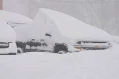
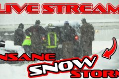
Winter Storm Warning with heavy snowfall closes Loveland Pass (Highway 6) requiring intermittent shutdowns for Hazard Materials (HM) Semi trucks getting special passage through Eisenhower tunnel. Shortly afterwards I-70 was also closed at Loveland and Vail passes effectively closing the Interstate Friday Afternoon.
Shot Description
1. I-70 west bound 1st sign of Loveland Pass Highway 6 closed
2. 2nd sign showing Highway 6 closure
3. Last sign before Highway 6 closure gate
4. Red Light on Interstate 70 while Hazardous semi loads are escorted through the Eisenhower tunnel
5. Traffic passing on East bound I-70 lanes
6. Traffic resumes West bound I-70
7. Emerging from the Eisenhower tunnel on West side of Loveland Pass
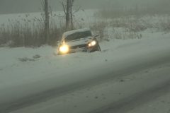
8. Snowy traffic on the sharp downhill into Dillon, CO
9. Near white out on off ramp into Dillon
10. Semi on shoulder in near whiteout
11. Slow semi in between heavy snows
12. Brake trouble on semi
13. Traffic on rural road in near white out
14. Traffic in Dillon
15. Traffic paused on I-70 West bound at Highway 6 exit
16. Snow blowing under Dillon 6/I-70 overpass
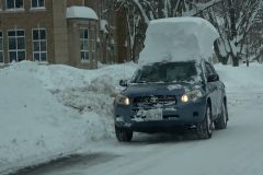
17. Car on snow packed road
18. Traffic in heavy snow
19. Snow plow on rural road
20. Trees in heavy snow
21. White River National Forest sign
22. Sapphire Point overlook sign snowed out view
SID: Terrence Cook
To License This Footage For Broadcast, Contact Video @ StormChasingVideo.com
#COWX
#winter
#weather
#icyroads
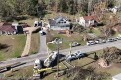
Elmore County / Blue Ridge, AL Drone Footage of Devastating Tornado Damage
Shot Description
00:00 Trees toppled on residential home
00:11 Linemen working on power lines with homes damaged in background
00:20 Trees flattened across hillside and up against homes
00:34 Residential neighborhood with trees uprooted
00:41 Circling around homes damaged and power crews working
00:58 Large trees uprooted and laying across roadway
01:05 Trees uprooted in front yard and homes damaged
01:15 Flyover with power crews working and damage below
01:25 Steady shot of trees laying on home
01:32 Steady shot of trees uprooted with trailer damaged
01:41 Flying away shot with crews working on clearing debris and fixing powerlines
01:54 Steady shot of multiple trees laying on home
02:02 Zoom in of multiple trees uprooted
02:09 Flyover with trees across roadway and homes damaged
02:23 Steady shot of trees laying on roof of home
02:30 Trees damaging home
02:38 Circle out of trees laying across roof of home
02:46 Flyover of trees completed destroyed
03:07 Circling shot of Trees uprooted and snapped off
03:20 Flyover of Tornado path leveling trees and crossing roadway and going up a hill
To License This Footage For Broadcast, Contact Video @ StormChasingVideo.com
#Drone
#tornad
#Alabama
#ALWX
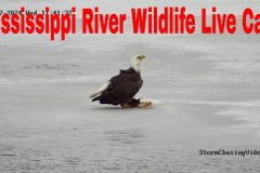
Our new Mississippi River wildlife camera. This camera is located on the banks of the Mississippi River in Brainerd, MN.
Flood Info for area https://water.weather.gov/ahps2/hydrograph.php?wfo=dlh&gage=bram5
On camera you will see a variety of wildlife from Deer, Wild Turkeys, Beavers, Wolves, Coyotes, Eagles, Foxes, Geese, Swans, Owls, Great Herons, Ducks, Groundhogs, Raccoons, Squirrels and even from time to time in the summer, Bears.
Majority of the wildlife is coming out after dark. Scroll back on the DVR option to see the various wildlife showing up in the middle of the night if nothing is happening currently.
#baldeagles
#baldeagleslive
#DeerLiveCam
#IRL
#MNWX
#MississippiRiver
#wildlife
#naturesounds
#relaxing
#trailcam
#naturecam
#mississippiriverlive
#theriver
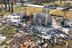
Wetumpka Montgomery County, AL Aerial Drone Footage of Tornado that caused Extensive Damage
Shot Description
Drone Footage of Tornado Damage
SID: Michael Gordon
To License This Footage For Broadcast, Contact Video @ StormChasingVideo.com
#Drone
#tornadodamage
#Alabama
#ALWX
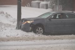
Blizzard conditions hit Oswego, NY with 40 to 45 mph wind gusts, blinding snow and big waves on Lake Ontario during a significant lake effect snow event.
All footage shot in/near Oswego, NY during evening daylight and darkness on November 20, 2022 by Meteorologist Simon Brewer
Shot Description
1-7. various shots of blizzard conditions in neighborhoods of Oswego, NY
8 & 9. car smashed into light pole from blizzard conditions in Oswego NY
10=20. various shots of pedestrians, traffic, and homes with blizzard conditions in Oswego, NY
21-23. shots of large crashing waves on Lake Ontario in Oswego, NY
24. pedestrian walking in blizzard conditions in Oswego NY
25-31. various shots of vehicles in ditches from snow-covered roads and blizzard conditions in/near Oswego NY
32 & 33. Lighted Christmas Tree with heavy snow blowing and falling
34. car driving in very heavy snow
35 & 36. snow plows clearing roads in Oswego NY
SID: Simon Brewer
Join this channel to get access to perks:
https://www.youtube.com/channel/UCWAN-rRJFLosqgiiIFVpkEQ/join
Meteorologist Simon Brewer is out in the lake effect winter snow storm and live storm chasing another INSANE AND VERY MASSIVE and dangerous Winter Storm moving over Lake Ontario to bring upwards of over 36-48 inches or 3-4 feet of snow to the Fulton, NY area. The large winter storm could bring snowfall rates of up to 4-6″ of snowfall per hour leaving the area in a pure whiteout. Be prepared and stay warm.
DONT FORGET TO SUBSCRIBE AND LIKE THE VIDEO. MUCH APPRECIATED FROM SCV!!!
Join this channel to get access to perks:
https://www.youtube.com/channel/UCWAN-rRJFLosqgiiIFVpkEQ/join
SID: Simon Brewer
To License This Footage For Broadcast, Contact Video @ StormChasingVideo.com
#lakeeffectsnow
#winterstorm
#snow
#nywx
#pulaski
#StormChasing
#severeweather
#irl
#syracuse
#lakeontario
Severe Winter Storm slams Oswego County, New York, including the Village of Mexico from an incredible 5th day of lake effect snow.
All footage shot during afternoon daylight on November 20, 2022 in/near the Village of Mexico, NY by Meteorologist Simon Brewer
Shot Description
1. “Mexico NY Fire Department” electronic sign in Mexico NY
2. American Flags blowing in heavy snow in Mexico NY
3 & 4. people shoveling sidewalk with heavy snow falling in Mexico NY
5. traffic with heavy snow in Mexico NY
6-9. various shots of accidents near Mexico NY from heavy snow
10. snowplow clearing snow in Mexico NY
11 & 12. pedestrians brave the heavy snow in Mexico NY
13-17. various shots of heavy snow falling on traffic and stores in Mexico NY
SID: Simon Brewer
To License This Footage For Broadcast, Contact Video @ StormChasingVideo.com
#Lakeeffectsnow
#winter
#NYWX
#weather
#icyroads
Join this channel to get access to perks:
https://www.youtube.com/channel/UCWAN-rRJFLosqgiiIFVpkEQ/join
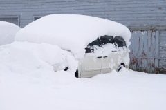
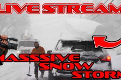
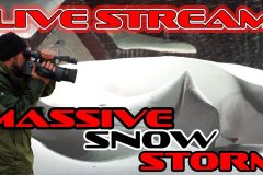
Residents dig out of Orchard Park, NY where 4-6 feet of snow was reported from a significant lake effect snow event.
All footage shot during morning daylight on November 19, 2022 in/near Orchard Park, NY by Michael Gordon and Simon Brewer.
Shot Description
1. “Orchard Park” Village sign surrounded by over 4 feet of snow
2. over 3 foot tall block of snow on car driving down road
3-20. various shots of neighborhoods buried in several feet of snow with residents “digging out” in Orchard Park, NY
SID: Michael Gordon Simon Brewer
Join this channel to get access to perks:
https://www.youtube.com/channel/UCWAN-rRJFLosqgiiIFVpkEQ/join
To License This Footage For Broadcast, Contact Video @ StormChasingVideo.com
#Lakeeffectsnow
#winter
#NYWX
#weather
#icyroads
Meteorologist Simon Brewer is out in the lake effect winter snow storm and live storm chasing this INSANE AND VERY MASSIVE and dangerous Winter Storm moving over Lake Erie to bring upwards of over 72-96 inches or 6-8 feet of snow to the Buffalo, NY area. The large winter storm could bring snowfall rates of up to 4-6″ of snowfall per hour leaving the area in a pure whiteout. Be prepared and stay warm.
DONT FORGET TO SUBSCRIBE AND LIKE THE VIDEO. MUCH APPRECIATED FROM SCV!!!
SID: Simon Brewer
To License This Footage For Broadcast, Contact Video @ StormChasingVideo.com
#lakeeffectsnow
#winterstorm
#snow
#nywx
#buffalony
#StormChasing
#severeweather
#irl
#buffalo
Vehicle on fire in heavy snow, stranded vehicles, and Hamburg, NY buried under 4 to 5 feet of snow!
All footage shot during evening daylight and darkness on November 18, 2022 in/near Hamburg, NY by Meteorologist Simon Brewer
Shot Description
1-6. car on fire stranded in very heavy snow in Hamburg NY
7 & 8. stranded van smoking with electrical fire as man uses snow to douse flames in Hamburg NY
9. front loaders clearing intersection in Hamburg NY
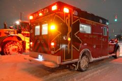
10. ambulance in Hamburg NY
11. stranded car in deep snow in Hamburg NY
12-21. various shots of buried homes, neighborhoods, businesses under 4 to 5 feet of snow in Hamburg NY
22-24. tractor pulls manufactured home in major winter storm surrounded by stranded cars in Hamburg NY
25-28. stranded snow plow, ambulance, and vehicles in deep snow in Hamburg NY
SID: Simon Brewer
To License This Footage For Broadcast, Contact Video @ StormChasingVideo.com
#Lakeeffectsnow
#winter
#NYWX
#weather
#icyroads
Meteorologist Simon Brewer is out in the lake effect winter snow storm and live storm chasing this EPIC AND VERY MASSIVE and dangerous Winter Storm moving over Lake Erie to bring upwards of over 48-72 inches or 4-6 feet of snow to the Buffalo, NY area. The large winter storm could bring snowfall rates of up to 4-6″ of snowfall per hour leaving the area in a pure whiteout. Be prepared and stay warm.
DONT FORGET TO SUBSCRIBE AND LIKE THE VIDEO. MUCH APPRECIATED FROM SCV!!!
SID: Simon Brewer
To License This Footage For Broadcast, Contact Video @ StormChasingVideo.com
#lakeeffectsnow
#winterstorm
#snow
#nywx
#buffalony
#StormChasing
#severeweather
#irl
#buffalo
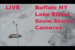
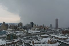
Traffic camera scan of winter weather road conditions around the Buffalo NY area as an epic lake effect snow setup is forecast starting Nov 17, 2022. Extreme heavy snow and thundersnow expected over the next 48 hours. Audio is NOAA weather radio and/or area public safety radio as warranted. Not a source of official traffics information. Source NY DOT.
#nywx
#traffic
#winter
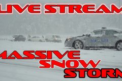
Snow Emergency for Hamburg, NY: over 3 feet of snow with buried neighborhoods, cars, gridlock on roads.
All footage shot during afternoon daylight on November 18, 2022 in Hamburg, NY by Michael Gordon and Meteorologist Simon Brewer
Shot Description
1 & 2. massive block of snow on car driving in Hamburg NY
3-13. various shots of accidents and gridlock traffic from deep snow in Hamburg NY
14-22. various shots of buried neighborhoods, cars, and snow plows in Hamburg NY
23 -25. various shots of “Highmark Stadium: Home of the Buffalo Bills”
SID: Michael Gordon Simon Brewer
To License This Footage For Broadcast, Contact Video @ StormChasingVideo.com
#Lakeeffectsnow
#winter
#NYWX
#weather
#icyroads
Amazing drone time lapse footage of the intense lake effect snow band next to downtown Buffalo, NY coming in off the lake.
Rare waterspout next to downtown Buffalo, NY over Lake Erie from a powerful lake effect snow band slamming the area. Some people call this a “Snownado”.
All footage shot during daylight on November 18, 2022 in Buffalo, NY by Michael Gordon and Meteorologist Simon Brewer
Shot Description
1. incredible drone footage time lapse of lake effect snow band over Lake Erie and Buffalo, NY
2-4. various drone shots of intense lake effect snow band hitting Buffalo NY
5-7. various shots of waterspout next to Buffalo, NY over Lake Erie caused by intense surface-based lake effect storm
SID: Michael Gordon Simon Brewer
To License This Footage For Broadcast, Contact Video @ StormChasingVideo.com
#Lakeeffectsnow
#winter
#NYWX
#weather
#drone
Meteorologist Simon Brewer is out in the lake effect winter snow storm and live storm chasing this EPIC AND VERY MASSIVE and dangerous Winter Storm moving over Lake Erie to bring upwards of over 48-72 inches or 4-6 feet of snow to the Syracuse, NY area. The large winter storm could bring snowfall rates of up to 4-6″ of snowfall per hour leaving the area in a pure whiteout. Be prepared and stay warm.
SID: Simon Brewer
To License This Footage For Broadcast, Contact Video @ StormChasingVideo.com
#lakeeffectsnow
#winterstorm
#snow
#nywx
#buffalony
#StormChasing
#severeweather
#irl
#syracuse
Multiple accidents, treacherous driving conditions, very low visibility, deep snow, and trees falling down from heavy wet snow in Parish, NY.
Beginning stages of potentially historic lake effect snow event for Upstate New York!
All footage shot during morning daylight on November 17, 2022 in/near the Village of Parish, NY by Meteorologist Simon Brewer
Shot Description
1-11. various shots of accidents from very heavy snow with emergency response in/near Parish, NY on Interstate 81
12-14. various shots of over a foot of snow burying vehicles in Parish, NY
15. powerlines sagging from weight over very heavy wet snow in Parish, NY
16-19. trees downed from heavy wet snow in Parish, NY
20 & 21. ruler measuring 17 inches of snow accumulation in Parish, NY
22-26. various shots of Parish, NY neighborhoods buried in 17 inches of deep snow
27-29. various POV shots of snow plows clearing Interstate 81 in Parish NY
30. power lines sagging under weight of very heavy wet snow in Parish NY
31 & 32. front loader clearing snow in parking lot in Parish NY
33. Electronic highway sign warning of Heavy Lake Effect Snow on Interstate 81 with traffic and heavy snow falling in Parish NY
34. snow-covered trees in Parish NY
SID: Simon Brewer
To License This Footage For Broadcast, Contact Video @ StormChasingVideo.com
#Lakeeffectsnow
#winter
#NYWX
#weather
#icyroads
Simon Brewer is live storm chasing this Massive and very dangerous winter storm moving over Lake Erie to bring upwards of over 48 inches or 4 feet of snow to the Buffalo, NY area. The large winter storm could bring snowfall rates of up to 4-6″ of snowfall per hour leaving the area in a pure whiteout. Be prepared and stay warm.
SID: Simon Brewer
To License This Footage For Broadcast, Contact Video @ StormChasingVideo.com
#lakeeffectsnow
#winterstorm
#snow
#nywx
#buffalony
#StormChasing
#severeweather
#irl
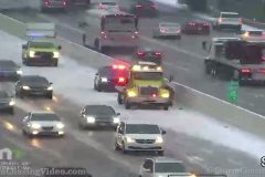
Autumn snowfall snarls traffic in the Minneapolis Metro causing multiple crashes on area highways. Heavy snow, poor visibility, multiple spinout and wreck scenes, emergency vehicles, congested traffic in falling snow and snow covered roads. Remote traffic camera video via MN DOT network. No audio.
Shot Description
1) Minneapolis highway sign with wet roads and snow on ground.
2) Wide shot of snow covered highway interchanges in Minneapolis metro area.
3) Heavy snow and poor visibility on highway.
4) Multi-vehicle accident scene #1
5) Multi-vehicle accident scene #2
6) Multi-vehicle accident scene #3
7) Multi-vehicle accident scene #4
8) Single vehicle accident scene.
9) Snow covered bridge and traffic.
10) Accident scene close with two fire trucks just arriving with first responders.
11) Single vehicle wreck with tow truck.
12) Multi-vehicle wreck scene.
13) Multi-vehicle accident scene with driver getting out.
14) Single vehicle accident scene with first responders walking up to car.
15) Spinout scene with first responders arriving.
16) Multi-vehicle wreck scene.
17,18,19,20) Four scenes of traffic in snow and poor visibility.
21) Flat bed towing away wrecked vehicle.
22) Traffic tight show in poor visibility in snow.
23) Intersection with US flag and snow.
24) Traffic in poor visibility in snow.
25) Accident just happed and white car with damage pulling off on shoulder.
26) Zoomed shot of damaged white car with driver and dog getting out then pullback to full accident scene.
27) Tight show off traffic in poor visibility and snow with school bus going thru frame.
SID: Brian Dombrowski
#MNWX #Winter #Snow
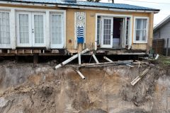
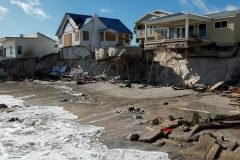
Raw footage from St. Johns County, Florida of the massive beach erosion and storm damage to the area.
Footage of destroyed structures and areas completely void of sand where large sand dunes once stood.
SID: Michael Gordon
#flwx #florida #hurricanenicole #aftermath #stjohnscounty
To License This Footage For Broadcast, Contact Video @ StormChasingVideo
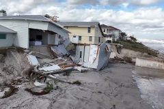
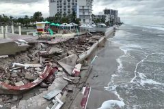
Raw footage from this morning, 11/11/2022, we did an extensive drone survey of the damage along the coast of Daytona Beach as the winds have now calmed down to the point where we are able to fly in a safer environment.
Footage shows the major coastal damage to the homes along the shore of Daytona Beach, Florida.
SID: Michael Gordon
#flwx #florida #hurricanenicole #aftermath #stormsurge #destroyedhomes
To License This Footage For Broadcast, Contact Video @ StormChasingVideo
Raw footage from this morning, 11/11/2022, we did an extensive drone survey of the damage along the coast of Daytona Beach as the winds have now calmed down to the point where we are able to fly in a safer environment.
Footage shows the major coastal damage to the homes along the shore of Daytona Beach, Florida.
SID: Michael Gordon
#flwx #florida #hurricanenicole #aftermath
Long Edit of the drone video showing the extensive and catastrophic damage along the shoreline of Daytona Beach Florida from Hurricane Nicole and the storm surge.
Buildings destroyed and foundations undermined as the waves ripped away the sand making the area unsafe for many of the structures.
Shot Description
00:00 Footage of the road block along the beach front properties.
00:11 Several clips of the catastrophic damage to hotels and condos along the beach with the sea walls destroyed and pool areas smashed.
01:34 Long clip of the major damage along the beach front to multiple structures.
02:57 Waves crashing into several destroyed areas.
03:57 Footage of undercut foundations and extensive damage to a large tall condo building.
05:33 Looking out over the waves off shore moving on shore.
05:46 Moving shot over several buildings that have damage.
06:14 Footage of the foundation exposed.
07:16 Destroyed pool decks.
08:13 Fly over shots showing extensive damage to beach front properties.
SID: Michael Gordon
#HurricaneNicole #FLWX #Florida #stormsurge #Drone
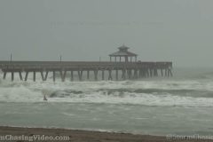
Hurricane Nicole Chase (South Florida to East-Central Treasure Coast)
Shot Description
1. Deerfield beach pier waves and surfers.
2. Fast moving clouds and rain (Deerfield Beach, FL).
3. 2 shots of flooding docks and marina in Jupiter, FL.
4. Leaves in road near Hobe Sound.
5. Radar shot and commentary, with road and leaves / debris.
6. Stuart Causeway.
7. 3 shots of picnic area off Stuart causeway.
8. 3 shots of south side of Stuart causeway and rising water.
9. Jensen Beach – 2 shots of storm surge coming down pathway and into parking lot.
10. Locals / storm chasers in strong winds on Jensen Beach.
11. 7 shots of Jensen beach causeway and flooding / surge with winds.
12. 3 shots of strong winds and rain in Fort Pierce.
13. Flooded road in Fort Pierce.
14. 3 shots of eyewall winds and rain in Fort Pierce.
15. Radar images of entering eye.
16. 2 shots of first entry into eye and moonlight.
17. Radar image showing myself inside eye.
18. Vertical shot of moon and calm eye.
19. 2 shots of calm eye, moon, and stars.
20. Backside of hurricane approaches.
21. Powerflash / transformer explodes.
22. Winds on backside of storm (last shot).
SID: CHRISTOPHER COLLURA
#HurricaneNicole #FLWX #Florida #stormsurge