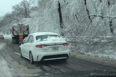
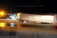
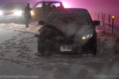
Massive pileup turns I-75 into parking lot near Lexington, KY from strong winter storm.
All footage shot in/near Lexington, KY during afternoon daylight on January 6, 2022 by Meteorologist Simon Brewer
Shot Description
1-5. various shots of massive pileup of various vehicles with emergency response on Interstate 75 near Lexington, KY, which is responsible for huge traffic jam through core of the state.
6-8. Footage of complete shutdown in both directions from the heavy snow and pile up.
9-11. cars sliding as they enter into massive traffic jam and pileup on I-75 near Lexington KY
11-21. various shots of massive traffic jam and pileup on I-75 near Lexington, KY
21-27. various shots of wrecked and stranded vehicles and heavy snow with low visibility on I-75 near Lexington, KY before pileup
28 & 29. heavy snow falling among trees next to I-75
SID: Simon Brewer
To License This Footage For Broadcast, Contact Video @ StormChasingVideo.com
#KYWX
#PileUP
#WinterStorm
#IRL
#i75
Aftermath and Cleanup of powerful winter storm in Washington D.C.
Trees felled from heavy wet snow on highways, snow plows clearing deep snow, and traffic in deep snow.
All footage shot during afternoon daylight on January 3, 2022 in Washington D.C. by Meteorologist Simon Brewer
Shot Description
1-8. various shots of trees down on highway from heavy wet snow with traffic and snow plows clearing deep snow with stuck vehicles in Washington D.C.
SID: Simon Brewer
To License This Footage For Broadcast, Contact Video @ StormChasingVideo.com
#DCWX
#WinterStorm
#HeavySnow
#Winter
#WinterStorm2022
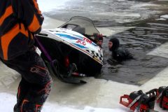
Despite the cold weather we have been having, a snowmobile went through the ice on New Years day. The snowmobile went through around dark that evening. Where the snowmobile wet through, there is a river/channel that connects Mud Lake to Lynda’s Lake aka The Narrows. Ice conditions ranged from 3 to 4 inches to around inch of ice in this area. This made for a dangerous ice recovery. The snowmobile was sitting in about 11 feet or so of water. Good news is there were no injuries reported.
Shot Description
Clip 1. Shows the area where the snowmobile went through the ice.
Clip 2. Shows running water not to far from us.
Clips 3-4. Britt cutting the ice out so they can start the recovery process.
Clips 5-6. The crew pushing the boat out to locate the snowmobile with an underwater camera.
Clips 7-8. The crew hooking up snowmobile with the aid of the underwater camera.
Clip 9. The crew pulling up the snowmobile so they can get it better hooked.
Clip 10. The crew hooking to more of a secure spots on the snowmobile.
Clip 11. Some of the crew pulling the snowmobile onto the ice, while two of the crew members are pushing and lifting the backside of the snowmobile.
Clip 12. Shows the snowmobile on the ice.
Clip 13. The snowmobile being towed off the ice, onto the shore then towards the parking lot.
SID: Dirk Miller
To License This Footage For Broadcast, Contact Video @ StormChasingVideo.com
#WIWX
#IceFishing
#ThinIce
#Winter
Winter Storm buries Boone, NC with over 9″ of heavy wet snow
Shot Description
00:00 Plow truck runs off side of road while plowing
00:16 Plow Truck being towed up and out of the ditch
00:23 Man shoveling in front of his business
00:29 Hoisting Plow Truck up onto the road to be towed
00:40 Gusty winds blowing across Hwy in Boone, NC
00:47 Commercial plow company plowing parking lot
00:51 Commercial plow truck plowing parking lot
00:58 High winds blow snow across highway
01:11 High winds blowing snow out of trees with fast moving clouds above
01:19 4 Clips of drone views above Boone, NC showing the cleanup and amount of snow
SID: Michael Gordon
To License This Footage For Broadcast, Contact Video @ StormChasingVideo.com
#winterstorm #boone
#WinterStorm2022
#SnowCleanup
#SnowStorm
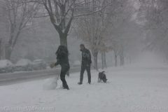
People in Richmond, VA enjoying the snow in the winter storm warning. Footage of people playing in the snow, kids sledding and people making a snowman.
Shot Description
Couple with a dog building a snowman
Another group building a snowman in heavy snow
Couple with dog building a snowman
Two children building a snowman
Kids sledding
Family taking a walk
People out for a walk
SID: William Hark
To License This Footage For Broadcast, Contact Video @ StormChasingVideo.com
#VAWX
#WinterStorm
#Whiteout
#WinterStorm2022
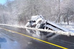
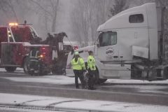
New footage in of some of the hundreds of crashes and spin outs today in Minnesota as the latest round of winter weather and sub zero temps have turned the roads into skating rinks.
It might have been a winter weather advisory but it was one of the more treacherous days on the road in central Minnesota in Stearns and Douglas Counties along Interstate 94 and Highway 23 with numerous crashes being reported.
The roads went from bad to extremely bad as the afternoon snow and freezing rain turned to glare ice as the air temps dropped into the sub zero range after sunset.
Shot List:
00:00 Crash Ahead Warning Sign
00:08 Car way off into the ditch along Interstate 94 in Stearns County
00:16 Snow Plow Side Shot, I94 Stearns County.
00:30 Several clips of a Jack Knifed Semi Truck on Highway 23 near Saint Cloud, MN
01:33 Five Clips of crashed vehicles along Interstate 94 near Sauk Centre, MN
02:18 Four Clips of crashed vehicles on Interstate 94 in Douglas County, MN
02:55 Snow Plows on Interstate 94 in Stearns County, MN
03:32 Crashed Vehicle on I94 in Stearns County, MN
03:38 After dark footage of a Jack Knifed Semi by Clearwater, MN on Interstate 94
04:39 After dark footage of a car in the ditch and being pulled out by a tow truck near Avon, MN on Interstate 94
To License This Footage For Broadcast, Contact Video @ StormChasingVideo.com
#Winter
#MNWX
#Minnesota
Video from on the edge the winter storm warning in St. Cloud, MN with a fresh coat of 3-4 inches of fresh snow. Footage showing a three car wreck on Interstate 94, snow plows, snow falling and tow truck recovering a stuck vehicle due to poor tires.
Shot Description
00:00 Snow plow on Highway 23 in downtown St. Cloud
00:13 Flags blowing in the heavy snow
00:21 Crash scenes on Interstate 94
01:32 Poor driving conditions with low visibility on I94
01:46 Following a snow plow in low visibility conditions on I94
02:01 Near whiteout conditions on I94 from the snow plow
02:32 MNDot snowplows on Highway 23
02:49 Car without winter tires is stuck in the deep snow and needed to be towed home.
03:24 Snow plow clips clearing snow from a parking lot
04:25 Heavy snow falling in downtown St. Cloud
04:36 – End – Several yards covered in Christmas Blowup Decorations in the blowing snow.
To License This Footage For Broadcast, Contact Video @ StormChasingVideo.com
#WinterStorm
#Minnesota
An extreme Bora Wind Event visited the Front Range bringing constant 40 mph winds with 80-90 gusts! Filmed across Boulder County, CO along highway 93.
Shot Description
1. Utility poles downed where an Enterprise truck was blown over
2. Close up on blown over truck
3. Downed utility pole swinging in the wind
4. Driving shot of over-turned truck
5. Broken stop lights at construction intersection
6. Broken stop light in wind
7. Snow plow clearing small branches from Highway 93
8. Vance Brand Airport wind sock at full report
9. High winds in tall grass
10. Waves on small reservoir
11. Dust storm forms
12. Dust obscuring mountains
13. Large dust clouds coming down foothills
14. Snow squall approaching Longmont at Sunrise
15. Pan of Snow Squall
16. Main convective updraft of snow squall
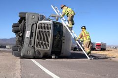
Extreme winds topple dozens of semis across I-25 in Colorado Springs, Colorado Dec. 15, 2021. Semi drivers had to be rescued from their trucks while winds reeked havoc across Colorado.
Shot Description
00:00 – Wide of parked trucks with wind lifting trailers
00:10 – Medium shot of wind lifting truck trailers
00:20 – Bystander braving extreme wind and dust next to tipped over truck waiting for fire department to rescue trapped driver
00:33 – Wide of firefighters using ladder to rescue trapped truck driver
00:54 – Truck driver exits cab while wind howls and blows around firefighters
01:08 – Tighter shot of driver climbing down ladder after rescue
01:22 – Firefighter climbing down ladder in extreme winds
01:34 – Box truck being tossed around in extreme winds, with dirt and debris being blown around vehicles on I-25
02:02 – Wide of trees being battered by wind
02:11 – Tight shot of trees being battered by wind
02:19 – Tipped over truck on northbound I-25
02:25 – Wide overview of dipped over trucks in close proximity, with knocked over signage
02:31 – Closer view of one of the tipped over trucks
02:37 – Closer view of truck tipped over in median after hitting guardrail and posts
02:44 – Another nearby truck, tipped over on the onramp to I25 northbound
02:49 – Another tipped over truck with emergency vehicles attending
02:57 – Wide of flags near building with extreme winds whipping them around and howling
03:08 – Close up of flags being whipped around by wind
03:16 – Stoplights being tossed around by the wind
03:26 – Man being blown around by wind with debris rolling and flying by
03:39 – AFTERMATH, metal apartment carports blown over
03:45 – AFTERMATH, metal apartment carports blown over, side view
03:53 – AFTERMATH, fence resting on car hood
04:00 – AFTERMATH, closer view of fence resting on car hood
04:05 – AFTERMATH, tree knocked over into apartment building
04:13 – AFTERMATH, tree knocked over into apartment building, roots
04:19 – AFTERMATH, large metal package hubs tipped over onto building
04:28 – AFTERMATH, large metal package hubs tipped over onto building with flags in view
04:34 – large metal package hubs tipped over onto building with zoom out from flags
04:44 – Don’t forget to close your windows in a wind storm *bad words*
#Colorado #ExtremeWinds #winds
To License This Footage Contact Video @ StormChaisngVideo.com
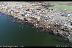
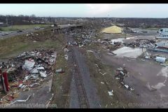
Massive tree damage, destroyed Reelfoot Lake Resort, destroyed town of Samburg, TN where 1st longtrack tornado dissipated.
All footage shot during evening daylight on December 14, 2021 in/near Samburg, TN by Meteorologist Simon Brewer and Professional Storm Chaser Michael Gordon.
Shot Description
1-15. various shots of devastating tornado damage to Reelfoot Lake, Samburg TN, and forest at end of 1st longtrack tornado path.
To License This Footage, Contact video @ StormChasingVideo.com
#Tornado #samburg #reelfoot #Kentucky #WX #Weather #quadstate #mayfield
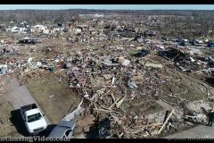
Drone and ground footage of most intense (highest wind speed) damage found so far along path of potential ‘Quad-State Tornado’ in Princeton, Kentucky
Several homes swept off foundations (solid EF4 damage), and cycloidal ground scouring over nearby fields.
All footage shot during afternoon daylight on December 13, 2021 in Princeton, KY by Meteorologist Simon Brewer and Professional Storm Chaser Michael Gordon.
Shot Description
Various shots from drone and ground of EF4 damage in Princeton, KY
#Tornado #Kentucky #damagepath
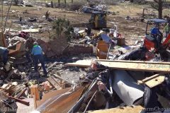
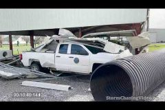
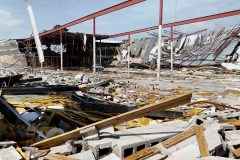
Significant damage from drone and ground in Dawson Springs, KY
Piles of cars on top of each other and obliterated neighborhoods.
All footage shot during afternoon daylight on December 13, 2021 in Dawson Springs, KY by Meteorologist Simon Brewer and Professional Chaser Michael Gordon.
Shot Description
Various significant damage from drone and ground in Dawson Springs, KY
Piles of cars on top of each other and obliterated neighborhoods with people sifting through damage.
#Tornado #Kentucky #Damagepath
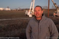
Drone shots of cycloidal ground scouring marks over field (ground swirls from violent longtrack tornado) and damage in/near Hayti, MO, including interview with storm chaser Michael Gordon.
All footage shot by Professional Storm Chaser Michael Gordon in/near Hayti, MO in evening daylight on December 12, 2021.
Shot Description
1-4. Interview with Storm Chaser Michael Gordon describing longtrack, violent tornado, which passed him on night near Hayti, MO causing ‘swirling ground scouring marks’ over a field called, “Cycloidal Scouring”
5. long drone shot of ‘cycloidal ground scouring’ over fields in Hayti, MO
6. shots of utility line repair and damage in Hayti, MO
Contact video @ stormchasingvideo.com to license this footage
#Tornado
#EF5
#ef4
#GroundScar
#GroundScouring
#CycloidalGroundScouring
#Mayfield
#Kentucky
#WX
#Weather
#quadstate
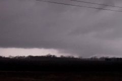
Night footage of large, wedge-shaped tornado near Coffeen, IL from supercell storm, which destroyed Amazon facility. Tornado lit by power flashes and lightning.
All footage shot during night darkness on December 10, 2021 near Coffeen, IL by Meteorologist Simon Brewer
Shot Description
1-10. various shots of lightning and power flashes illuminating a large, wedge-shaped tornado near Coffeen, IL
11-13. shot of another supercell, lightning and heavy downpour in central Illinois after tornado passed
Contact video @ stormchasingvideo.com to license this footage
#Tornado
#EF5
#ef4
#GroundScar
#GroundScouring
#CycloidalGroundScouring
#Mayfield
#Kentucky
#WX
#Weather
#quadstate
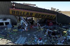
Mayfield, KY Damage survey by Meteorologist Simon Brewer and Professional Storm Chaser and Expert Drone Pilot Michael Gordon at the beginning of long track tornado near Greenfield, AR including 1st major damage to rice facility.
Video includes clips from:
Damage in Bowman, AR
Nursing home damage in Monette, AR
Cotton Gin and Dollar General destroyed in Leachville, AR
Power recovery effort at all locations.
All footage shot in northeastern Arkansas by Meteorologist Simon Brewer and Professional Storm Chaser Michael Gordon during daylight on December 12, 2021.
Shot Description
1-5. shots of beginning of long track, violent tornado (potential “Quad State Tornado”) near Greenfield, AR with damage to Rice plant
6-9. various shots of damage and recovery near Bowman, AR (next town in path)
10-22. various shots of Nursing Home and destroyed in Monette, AR (next town in path)
23-26. shots of damage to high voltage powerlines, and irrigation equipment between Monette and Leachville, AR
27-31. various shots of a massive cotton gin destroyed with cotton bails scattered over Leachville, AR
32-45. various shots of destroyed “Dollar General” store in Leachville, AR
Contact video @ stormchasingvideo.com to license this footage
#Tornado
#AR
#Arkansas
#ef4
#GroundScouring
#CycloidalGroundScouring
#Mayfield
#Kentucky
#WX
#Weather
#quadstate
#dji
Drone Footage of the Devastating Aftermath cause by a very violent Tornado that tore through Mayfield, Kentucky.
Shot Description
1-3 Candle Factory Drone Footage
3-17 Drone footage along the path to the center of Mayfield, KY
SID: Michael Gordon
Contact video @ stormchasingvideo.com to license this footage
#Tornado
#EF5
#ef4
#GroundScar
#GroundScouring
#CycloidalGroundScouring
#Mayfield
#Kentucky
#WX
#Weather
#quadstate
Winter storm is moving through the area this evening and night. This storm has caused problems on the roadways tonight. This video package will show some of the problems on the roadways, along with some Holiday cheer.
Shot Description
Clip 1. Dash cam footage of a car in the ditch on the off ramp of HWY 53 just west of Rice Lake.
Clip 2. A SUV fishtailing.
Clip 3. Two trucks fishtailing.
Clip 4. Another truck fishtailing.
Clip 5. A wide shot of flags blowing in the wind with heavy snow falling.
Clip 6. A hypnotizing close up shot a flag blowing in the wind with heavy snow falling.
Clip 7. Wide shot of snow blowing off a roof.
Clip 8. A slightly different angle of the snow blowing off the same room.
Clip 9. Heavy snow falling with part of the Christmas display.
Clip 10. A different shot of the cabin with more of the Christmas display, along with heavy snow falling.
Clip 11. A wide shot of the Christmas display.
Clip 12. A couple out in the winter storm taken pictures of the Christmas display.
Clip 13. Heavy snow falling with a snow covered trees, along with s mall part of the Christmas display.
Clip 14. Close up shot of the reindeer with snow falling.
Clip 15. A snow covered road with snow falling.
A strong winter storm is impacting the Midwest with snowfall rates at times of 1 to 2 inches an hour. Roads were quickly deteriating across the Twin Cities region with several car accidents being reported. The Minneapolis-St. Paul International Airport is also being greatly impacted by the winter storm with over 200 cancelled flights being reported at this time as reduced visibility from the moderate to heavy snow is to blame. In the following video there is video of a jack knifed semi truck blocking two lanes of traffic along with video from the Minnesapolis-St. Paul International Airport of planes landing, taking off, snow removal, and more!
Shot List:
Shot 1: Plow truck goes by as two tow trucks work on moving a jack knifed semi in the background with crews walking around in front of the semi.
Shot 2: Minnesota State Patrol stands in front of his car at the scene of the semi jack knife.
Shot 3: County crews work to clean up spilled fuel from the jack knifed semi that was spilled on the road in and in the snow.
Shot 4-5: Another plow truck drives past the crash scene going the opposite direction plowing the road.
Shot 6-7: Crews work to clean up and move the semi truck while State Patrol keeps an eye on traffic driving by.
Shot 8: Winter scene showing snow covered roads and reduced visibilities.
Shot 9: Delta Airlines plane taking off from the Minneapolis-St. Paul International Airport into heavy snow.
Shot 10: Delta Airlines plane being de-iced before it takes off. Very poor visibility present in heavy snow.
Shot 11: United Airlines plane landing at Minneapolis-St. Paul International Airport in heavy snow and reduced visibility.
Shot 12-13: Delta Airlines planes taxing to end of runway to take off in heavy snow fall.
Shot 14: Delta Airlines plane being de-iced while airport vehicle drives in the foreground.
Shot 15-17: Snow removal crew clearing the taxi lane at Minneapolis-St. Paul International Airport
Shot 18: Snow removal crew clearing the taxi lane at Minneapolis-St. Paul International Airport as Delta Airlines plane lands in the background in heavy snow.
Shot 19-21: Close up and medium shots of Snow removal crew clearing the taxi lane at Minneapolis-St. Paul International Airport.
Shot 22: Delta Airlines plane landing at Minneapolis-St. Paul International Airport in heavy snow as another plane taxis in the foreground.
Shot 23: Close up shot of Delta Airlines plane taxing to take off with snow removal crew sitting in the foreground.
Shot 24: Wide shot of full snow removal crew waiting for planes to land and take off before they continue to clear the runways.
Shot 25: Close up shot of snow removal crew at the Minneapolis-St. Paul International Airport with a Delta Airlines plane landing in the background in heavy snow.
Strong winter storm is effecting northwestern WI. Here is Rice Lake WI. We picked up around 4 inches of snow. The wind is what is causing problem around here. Winds gusting up to 32 MPH is causing blowing and drifting snow. This video package will highlight the blowing snow.
Shot Description
Clip 1. Heavy snow falling.
Clip 2. Swans on the river with snow falling.
Clips 3-8. Shows blowing snow in different areas.
Clip 9. Barron County Sheriff’s office at a scene of an accident.
Clips 10- 12. Snow blowing off of different roofs.
Clips 13-14. Vehicle’s tires kicking up slush on main street in Rice Lake.
Clips 15-16. A snow plow plowing snow.
Clip 17. A flag blowing in the wind.
Clip 18. Bank temp of 24 degrees.
Drone Survey of Grand Isle, LA after Hurricane Nicholas feeder bands rolled through the area causing flash flooding and hindering the extensive cleanup efforts caused by Hurricane Ida.
Shot Description
00:00 Flooding over the most devastated part of Grand Isle, LA with most structures removed from their foundations or demolished
00:19 Military vehicles and others lined up in the flooded waters waiting to cross a deep stretch of water
00:31 Flyby view of the line of vehicles in the flooded waters
00:35 Head On view of vehicles driving down the main road in flooded waters
00:44 Low level flight of extensive damage and standing water with homes lifted from foundation
00:49 Emergency Contractor driving through the flooded street
00:57 Lines of military vehicles and contractors on the flooded road
01:06 Excavator removing sand from the road in flooded water
01:13 Sky Line view of the middle of the island
01:19 Bay view of homes destroyed
01:29 15-20 Structures removed from their foundations
01:38 Overview shot of the worst devastation
01:45 Flyover of multiple structures with extensive damage
01:53 Zoomout of homes removed from foundations
02:10 Extensive damage to homes
02:18 Low-level view of debris scattered with piles of sand covering the island
02:25 Non-existent road covered with sand and a car buried in feet of sand
02:34 Structural debris scattered in every direction covered in heaps of sand and water
02:43 Multiple homes removed from foundations with debris and water
02:53 Interior home appliances and belongings in piles
03:02 Interior home appliances and belongings in piles
03:13 Vehicle buried in feet of sand
03:15 Roadway view of extensive flooding
03:23 Overhead view of military vehicles driving through the flooded street
03:28 Vehicles driving through the flooded street
03:42 Overview shot of the mass destruction
03:57 Docks on the bay side of the island destroyed
04:10 Convoy of vehicles driving through very deep water
04:23 Convoy of vehicles driving through very deep water
04:28 Convoy of vehicles driving through very deep water
04:39 Convoy of vehicles driving through very deep water
04:49 Convoy of vehicles driving through very deep water
05:12 Sky view overhead of destruction and vehicles driving through flooded water
05:23 Sky view overhead of destruction and vehicles driving through flooded water
05:35 Semi driving through flooded waters overhead
05:44 Structures damaged and destroyed sitting in flooded waters
05:53 Zoom in of structure with no roof
06:01 Debris scattered in feet of sand
06:10 Zoom in of structured destroyed with roof missing
06:16 Overview shots of devastating damage
06:24 Overview shots of devastating damage
06:35 Overview shots of devastating damage
06:43 Zoom in of a residence with the walls missing where you can see a toilet still attached
06:59 Military Humvee cruising through flooded waters
07:12 Overview shot of the west part of the island with the sun showing through the clouds
07:26 West part of the island destruction
07:33 Zoom in of a structure near the Grand Isle, LA levee system removed from its foundation
07:47 Stunning panoramic shot of all Grand Isle, LA at 380ft with remnants of Hurricane Nicholas off the coast
08:01 Flyby view of extensive damage
08:09 Residence completely destroyed directly behind the levee system
08:16 Multiple structures heavily damaged behind the levee system
#hurricane
#hurricaneida
#goldenmeadow
#cat4
#category4
#hurricanes
#lawx
#grandisle
SID: Michael Gordon
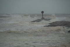
Strong feeder bands, heavy rain, gusty winds, and large swells begin hitting Matagorda, TX as Tropical Storm Nicholas moves toward this coastal community.
All footage shot in/near Matagorda, TX and greater Houston Metro area during afternoon daylight on September 13, 2021 by Meteorologist Simon Brewer
Clip Description
1-11. various shots of strong Tropical Storm Nicholas feeder band dumping heavy rain and gusty winds near Matagorda, TX
12 & 13. gusty winds blowing sand on dunes and beach as Nicholas closes in on Matagorda, TX
14-18. various shots of large frothy swells and central dense overcast as Tropical Storm Nicholas moves toward Matagorda, TX
19 & 20. heavy rain and gusty winds as Nicholas moves toward Matagorda, TX
21 & 22. electronic Houston Metro area sign warning of approaching Tropical Storm
SID: Simon Brewer
Complete News Archive Footage For Licensing.
Archive footage of Hurricane Ida in Houma, LA. Timecoded footage of the impacts of Hurricane Ida on the area.
To license this footage, visit StormChasingVideo.com
Almost 20 minutes of raw news video clips from around the Golden Meadow, LA area where catastrophic Hurricane Ida hit the area hard on Sunday.
This raw footage is being uploaded to help residents and family of residents see the area and what is left and what is destroyed.
This is all aftermath footage from the Golden Meadow, Galliano and Cut Off Louisiana area from our crew before they left the area today.
Flooding damage from the storm surge. Multiple structures severely damaged. Fishing vessels capsized. and lots of commercial and residential buildings heavily damaged from the wind ripping roofs off with debris everywhere.
Shot Description
#hurricane
#hurricaneida
#goldenmeadow
#cat4
#category4
#hurricanes
#lawx
SID: Michael Gordon
New news footage just out of Golden Meadow, LA where catastrophic Hurricane Ida hit the area hard on Sunday. Aftermath footage from the Golden Meadow, Galliano and Cut Off Louisiana.
Flooding damage from the storm surge. Multiple structures severely damaged. Fishing vessels capsized. and lots of commercial and residential buildings heavily damaged from the wind ripping roofs off with debris everywhere.
Shot Description
Almost 10 minutes of aftermath footage from the Golden Meadow, LA area showing the total destruction of the area after Hurricane Ida.
#hurricane
#hurricaneida
#goldenmeadow
#cat4
#category4
#hurricanes
#lawx
SID: Michael Gordon
To help support our freelancers, buy them coffee. https://www.buymeacoffee.com/stormchasing/
To License This Footage For Broadcast, Contact Video @ StormChasingVideo.com
Our Team Merch Store – https://stormchasingvideo.creator-spring.com