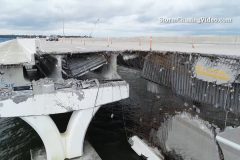
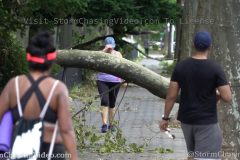
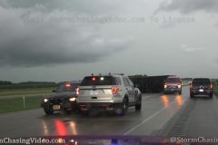
Raw Drone Footage Of The Catastrophic Damage To The Three Mile Bridge. No Audio
Footage of the multiple destroyed section of the Highway 98 Three Mile Pensacola Bay Bridge that was hit by several run away barges during Hurricane Sally. Incredible footage showing massive sections of the bridge laying on top of a barge. Footage of huge sections of the bridges destroyed and damaged by the barges hitting the bridge during Hurricane Sally.
Shot Description
00:00 – Approaching the first damaged section of the Three Mile Bay Bridge.
00:14 – Tight shot of the damage from just above the water showing the road surface hanging into the water.
00:21 – Overhead footage of the extensive damage where it looks as if a barge was bouncing off the side of the bridge.
00:35 – Traveling and orbit shot to of the damaged sections of the bridge.
01:15 – Flyby of damage and another barge in the distance that hit the bridge.
01:42 – Orbit of the second damaged section of the bridge with additional sections of the bridge on a barge stuck under the collapsed bridge.
02:34 – Tight orbit of the second collapsed section of the bridge on top of a barge.
03:16 – Long shot and fly by of both damaged sections of the bridge with both barges stuck under the bridge.
05:08 – Tight shot of the catastrophic damage to the Three Mile Bridge.
05:15 – Pan shot of the catastrophic damage with rebar hanging out of what is left of the bridge.
05:35 – Orbit shot of construction equipment that slammed into the Three Mile Bridge and laying on the side of the bridge.
05:59 – A third barge that broke loose and was stuck under the bridge.
06:28 – Lower angle shot of the third barge stuck under the Three Mile Bridge where the large steel storage containers and equipment on the barge is smashed on the deck.
07:36 – Orbit of the third barge stuck and smashed under the Three Mile Bridge.
07:52 – Fly by shot of another barge in the water near the bridge for reference of that was on the deck of the third barge with the equipment smashed on its deck under the bridge.
08:32 – Fly by shot of a barge that ran aground on shore.
09:02 – Tight and orbit shot of the barge that ran aground next to a road and traffic driving by.
SID: Michael Gordon
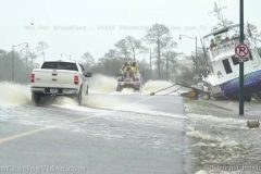
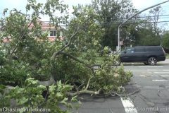
Boats in roads and yards, surge water in neighborhoods, cars underwater, high winds damage in Orange Beach, AL from powerful Hurricane Sally.
All footage shot during morning daylight on September 16, 2020 in Orange Beach, AL by Meteorologist Simon Brewer
Shot Description
Various shots of:
-boats deposited on highways, roads, and neighborhood yards by storm surge from Hurricane Sally
-cars in water
-homes surrounded by storm surge water
-high wind damage to homes and businesses
-trees down
-light poles down
SID: Simon Brewer
To help support our freelancers, buy them coffee. https://www.buymeacoffee.com/stormchasing/
To License This Footage For Broadcast, Contact Video @ StormChasingVideo.com
Our Team Merch Store – https://stormchasingvideo.creator-spring.com
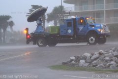
Powerful winds and surge high Orange Beach, AL as outer edges of Hurricane Sally eyewall inch over coast.
All footage shot in/near Orange Beach, AL during evening darkness and daylight on September 15, 2020 by Meteorologist Simon Brewer
Shot Description
1-3. storm surge moves into Orange Beach, AL
4. emergency vehicles race through Orange Beach during high winds
5. high winds blow palm tree
6 & 7. street lights tossed around in high winds
8. electrical sparks from powerlines damaged by high winds
9. high winds blast beach houses
10-16. various shots of firetrucks, sheriffs, and emergency vehicles racing to close and block causeway leading out of Orange Beach, AL
17. high winds blast palm trees
18. mobile doppler radar truck in high winds in Orange Beach, AL
19-24. various shots of high winds blasting Orange Beach, AL
SID: Simon Brewer
High winds and heavy rain impact Gulf Shores, AL, as the outer eyewall of Hurricane Sally encroaches into the area. Several buildings have sustained damage, and heavy rainfall has begun to inundate roadways.
Shot Description
1. High winds whipping palm trees and hurricane warning flags
2. “Gulf Waters Closed” sign indicated that beaches are closed
3-4. Rain being blown horizontally by strong winds in a Gulf Shores neighborhood
5. Residents pumping gas at one of the only open gas stations as high winds and heavy rain begin to impact Gulf Shores
6-7. Tree fallen on top of a car.
8-9. A condominium unit with siding blown off.
10. Siding blown off the condominium unit lying on the ground.
11. A piece of siding flying underneath a stilted house.
12. Rainwater flowing rapidly off the roof of a local business.
13-14. Cars driving through floodwaters beginning to inundate local roads.
15-16. Sand blowing and large waves crashing due to strong wind gusts.
SID: Trey Greenwood
Initial impacts in the city of Gulf Shores, AL, from from the outer bands of Hurricane Sally as it approaches the Gulf Coast.
Shot Description
1. Hurricane Warning sign above Interstate 10 in SE Mississippi
2. Emergency crews responding to a call in Foley, AL
3. Road closed due to flooding in Gulf Shores, AL (wide)
4. Road closed due to flooding in Gulf Shores, AL (tight)
5. Flooding over roadway in Gulf Shores (wide)
6. Palm trees and power lines swaying in the wind in Gulf Shores
7. Hurricane warning flags flying with waves crashing in the background in Gulf Shores
8. Hurricane warning flags flying in Gulf Shores
9. Blowing sand and waves crashing within outer band of Sally in Gulf Shores
10-14. Various wide and tight shots of waves crashing in Gulf Shores
SID: Trey Greenwood
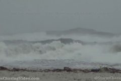
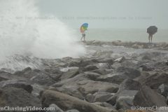
Hurricane Sally (Tropical Storm Sally) sends pounding surf, surge, wind & heavy rain into the southwest coast of Florida. Video is shot at the Venice Jetty which is an inlet from the Gulf of Mexico at Venice Florida. Large wave pounding jetty seawalls and park area, people interacting with Sally’s weather, road flooding.
Shot Description
1) POV surging wave hits camera at Venice FL north jetty.
2) People with umbrellas walking jetty while seas pound the jetty in rain.
3) Waves hit jetty near picnic table.
4) Picnic table in surge waters.
5) Picnic table with waves hitting wall behind.
6) Waves hitting south jetty.
7) High surf along beach looking SW.
8,9,10) Two more shots of waves hitting jetty and wind blown spray.
11) Park refuse can in surge flood water.
12) Crazy guy in boat out in channel during a tropical storm. Only boat seen out on water.
13) POV wave splashing camera.
14) Looking a waves splash high on jetty with park benches.
15) People in rain coats venture onto jetty with waves splashing.
16) Waves hit behind park benches.
17,18) Surge water submerging dock by sailboat.
19) Road Underwater sign with pick up truck barreling through flood water.
20-23) Four shots of vehicles splashing in flooded roads.
SID: Brian Dombrowski
B-Roll footage from the day after of the catastrophic damage to the downtown area of Lake Charles, LA.
Footage of the Capital One Bank Building with the windows blown out and crews cleaning up glass and debris around the building.
Additional footage of damaged buildings, signs and downed power lines and the TV Antenna that fell in the hurricane and crushed the building next to it.
Shot Description
00:00 – B-Roll shots of the Capital One building and crews cleaning up around it.
00:37 – Destroyed Wendy’s sign with the Capital One building in the background.
00:37 – Destroyed sign for the Lake Charles Civic Center.
00:43 – Debris on the ground and crews cleaning up around the Capital One building.
01:08 – Downed utility poles and National Guard vehicles driving by.
01:21 – Destroyed TV station antenna.
01:50 – Downed utility poles and traffic.
02:15 – Damaged homes.
SID: Simon Brewer
Tornado-warned cell imbedded in feeder band with funnel cloud moves over Lake Arthur, LA as people try to evacuate from monster Hurricane Laura.
All footage shot in/near Lake Arthur, LA during afternoon of August 26, 2020 by Meteorologist Simon Brewer
Shot Description
1. Doppler on wheels radar with tornado-warned storm in background
2. trashcan blown by high winds on highway
3-8. various shots of wall cloud and funnel cloud over Lake Arthur, LA
9-14. various shots of heavy rain and high winds in Lake Arthur, LA as tornado-warned cell passes over
15-21. various shots of people evacuating from Lake Arthur, LA as tornado-warned cell from Hurricane Laura approaches
SID: Simon Brewer
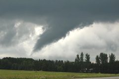
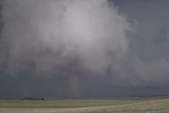
Raw footage of a Tornado warned storm that put down multiple tornadoes at the same time just west of the city of Park Rapids, MN in Hubbard County, Minnesota.
Total footage runtime is 13:26 with several areas of the storm touching down at the same time that may have been part of a larger multi-vortex system.
Shot Description
00:00 – Dash camera footage of the tornado starting to form just west of Park Rapids, MN.
00:36 – Tornado forming and then pans back to the left to another tornado touching down.
03:03 – Pan to the right to a larger tornado touching down.
07:11 – Tornado forming on the other side of the road. Traffic does drive in front of the shot at times.
11:22 – Tornado from the other side of the road without traffic driving in front of the camera.
SID: Melanie Metz
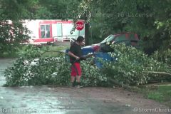
Incredible widespread tree damage aftermath from Tropical Storm Isaias in Astoria Park, Astoria, Queens, NYC, NY.
Massive trees and limbs down on cars, guard rails, lights, blocking paths and roads.
All footage shot during afternoon daylight on August 3, 2020 in Astoria, Queens, NY by Meteorologist Simon Brewer.
Shot Description
1-30. various shots of massive trees and tree branches down from extremely high winds with passing of Tropical Storm Isaias in and around Astoria Park in Astoria, Queens, NY with pedestrians walking around and still trying to enjoy the park. Wind gusts around 70 mph were recorded in the area
SID: Simon Brewer
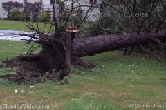
Tropical Storm Isaias affected the southern shore of Long Islans NY with sustained winds over 50mph and frequent gusts to hurricane force. This brought down numerous trees and caused other damage around the area.
Shot Description
SHOT 1: A large tree toppled over blocking a sidewalk.
SHOT 2: Panning shot of a tree that fell over into the street blocking traffic.
SHOT 3: Strong winds blowing sand down the street near Atlantic Beach NY.
SHOT 4: Strong winds starting to rip the shingles off a roof in Rockaway NY.
SHOT 5: Strong winds blowing trash around in Rockaway NY.
SHOT 6: Strong winds and rain soaking a woman walking her dog on the boardwalk.
SHOT 7: Wind damaged an outdoor tent in Long Beach NY.
SHOT 8: Police directing traffic around a downed traffic signal.
SHOT 9: Downed trees along Beech St in Long Beach NY.
SHOT 10: Close-up of an anemometer displaying wind gusting over 60mph.
SHOT 11: Strong winds and heavy surf at Rockaway Beach.
CAT 1 Hurricane Isaias makes landfall over Ocean Isle Beach, NC causing significant storm surge and high winds causing damage.
To help support our freelancers, buy them coffee. https://www.buymeacoffee.com/stormchasing/
To License This Footage For Broadcast, Contact Video @ StormChasingVideo.com
Our Team Merch Store – https://stormchasingvideo.creator-spring.com
Footage of stars visible inside small clearings in the eye. Also, footage of storm surge flooding and waves in Garden City, SC as storm approaches.
All footage shot during evening daylight and darkness on August 3, 2020 in Ocean Isle Beach, NC and Garden City, SC by Meteorologist Simon Brewer.
Shot Description
1-3. footage of significant storm surge flooding in Ocean Isle Beach, NC
4-13. various shots of high damaging in Ocean Isle Beach, NC during strong eyewall of Hurricane Isaias
14. high winds blowing traffic lights in Ocean Isle Beach, NC
15. stars visible through clearing in center of ‘eye’ of Hurricane Isaias in Ocean Isle Beach, NC
16-18. various shots of storm surge flooding during eye of Hurricane Isaias in Ocean Isle Beach, NC
19. 990.1 mb barometric minimum pressure measured in eye of Hurricane Isaias as it passed over Ocean Isle Beach, NC
20-30. various shots of large waves and storm surge flooding in Garden City, SC as Hurricane Isaias approached.
SID: Simon Brewer
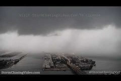
Video looking out over port of Miami Florida as Hurricane Isaias approaches SE Florida. Heavy rain bands from squalls moving into Miami from the Atlantic as clouds spin counter-clockwise around the storms center, moving from North to South. Also includes time-lapse showing cloud movement. HD robotic remote camera video. No audio.
Shot Description
1-10) Ten clips of dark storms clouds and heavy rain from the outer bands of Hurricane Isaias coming into the desolate port of Miami FL from the Atlantic Ocean. All the cruise and container ships have left ahead of the approaching storm.
11,12) Two different time-lapse clips showing cloud movement from north to south as storm spins counter clockwise offshore.
Storm B-Roll with some time lapse and tornado that briefly touched down near Mankato, MN
Shot Description
Various time lapse and real time footage of severe and tornado warned storm near Mankato, MN.
A long track supercell that developed in northeastern Wyoming tracked through the Black Hills of South Dakota before eventually moving southeast into northwestern Nebraska as part of a developing MCS that pushed into Central Nebraska late into Friday night. This storm was responsible for a brief tornado west of the town of Martin where this video package was shot. It opens in the “bear cage” with blinding rain and wind as the reported tornado moved within a mile of the photographer. Ends with minor flooding and tree damage in town.
Martin, SD is 100 miles southeast of Rapid City near the Nebraska border.
Shot Description
Clips 1-4: Driving west of town around the time of the tornado report as the rain-wrapped hook crossed US Highway 18.
Clips 5-6: Very high winds blowing rain through the grass around the car.
Clips 7-11: Shots of high winds on the backside of the storm in Martin.
Clips 12-14: Various shots of water covering US-18 in town with cars navigating through.
Clips 15-17: Shots of a large tree limb that crashed down on the back of a pickup truck.
Clip 18: Man removing tree debris from the street.
Clip 19-23: Various shots of large tree debris littering yards in town.
Clips 24-25: POV driving lightning strikes.
Several tornadoes touched down in northwestern Minnesota during the later afternoon hours in Ottertail County, MN near the town of Dalton, MN.
Footage includes multiple tornadoes and multiple angles of the same tornado that was on the ground for over ten minutes. Also included with the video are a couple of time lapse clips of the longer raw material.
Shot Description
Clip 1 Extremely large tornado with debris in the air with good audio talking about how you can smell the debris in the air.
Clip 2 – 3 Tripoded longer cuts of the tornado perfectly positioned in the shot as it moves from right to left.
Clip 4 – 5 Roof top mounted camera driving up to the tornado.
Clip 6 Timelapsed footage from all of the footage from clips 2-3. Footage speed is 1,000 times faster then the normal speed.
Clip 7 Tornado and faint rainbow in a field..
Clip 8 – 12 various clips of the tornado almost stationary in an open field.
Clip 13 Wide shot of the tornado and the storm clouds with structure.
Clip 14 Tornado stating to rope out and weaken.
Clip 15 Tornado just vanishes right in front of the camera.
Clip 16 Time lapse of all the raw footage from clips 7 to 15 of over 10 minutes of raw footage of the tornado before is vanishes.
Clip 17-18 Large Cone Tornado with debris in the rain with a white on white contrast.
SID: Melanie Metz
Tornado, dramatic supercell thunderstorm with Time Lapse shots, and wind damage near the town of Arnold, NE
All footage shot in/near the town of Arnold, NE on June 8, 2020 by Meteorologist Simon Brewer
Shot Description
1. funnel cloud near Arnold, NE
2-4. Dusty tornado near the town of Arnold, NE
5 & 6. damage and debris caused by high winds from tornadic supercell near Arnold, NE
7-12. various shots of dramatic tornadic supercell thunderstorm near Arnold, NE including Time Lapse shots
Heavy rain bands from Tropical Storm Cristobal are coming ashore at SW Florida’s coast Saturday. The heavy rain is impacting people shopping for groceries during the pandemic, motorists on roads, and those trying to return to normal and enjoy the beach at Siesta Key beach. Torrential rain, road flooding, blustery winds and building surf. Low angle traffic splash shots included.
To help support our freelancers, buy them coffee. https://www.buymeacoffee.com/stormchasing/
To License This Footage For Broadcast, Contact Video @ StormChasingVideo.com
Our Team Merch Store – https://stormchasingvideo.creator-spring.com
Shot Description
1) Low angle shots of US 41 in Sarasota with traffic splashing the housed camera in rood flooding.
2) Slow motion shot of box truck splashing the camera.
3,4) Grocery shoppers with carts, umbrellas and rain gear headed to load their cars in extremely heavy rain.
5) Cars in lot pounded by rain.
6) People with masks and umbrellas in heavy rain attempting to load groceries into car.
7) Amazon delivery truck in heavy rain.
8,9) Rain water gushing off tile roof.
10) Close shot of rain on SUV roof.
11) Flowering planted drowned in flood water.
12,13,14,15,16) Five shots of traffic splashing in flooded areas of downtown Sarasota.
17) Low angle shots of traffic on US 41 splashing housed camera.
18) Siesta Key Beach welcome sign and people with umbrellas in rain.
19) Blue lifeguard tower with red warning & US flags and people with umbrellas and rain gear.
20) Woman with rain umbrella and man with beach chairs in rain.
21,22,23) Green lifeguard tower with red swim warning flag for high surf and rip tides.
24) Beach conditions sign at Siesta Key Beach.
25) Guy in surf with son on paddle board hit by wave when not paying attention.
26) People on beach with high surf from tropical storm.
27) Woman with umbrella on beach in rain watching surf.
28,29,30) People in Gulf of Mexico swimming in high surf from Cristobal.
31) Woman with umbrella while man has camera phone filming Gulf of Mexico.
32) Lifeguard truck.
33) People in beach chairs under umbrella watching storm.
34) Guy jogging beach in rain.
35) Woman leaving beach with rain umbrella.
Powerful tornado-warned supercell thunderstorm with rotating wall cloud causes damage in Glens Falls, NY, and causes shut down of Interstate 87.
Footage of rare, incredible supercell structure in Upstate New York, large wall cloud, very CLOSE lightning strike, damage, and huge traffic jam on I-87 caused by traffic diversion off closed section of Interstate.
All footage shot during evening daylight on May 29, 2020 in Glens Falls, NY by Meteorologist Simon Brewer
Shot Description
1-5. various shots of tornado-warned supercell thunderstorm and large wall cloud approaching Glens Falls, NY with rare incredible structure for Upstate New York
6 & 7. CLOSE lightning strike in Glens Falls, NY from tornado-warned storm
8-12. tornado warned supercell and wall cloud slam Glens Falls, NY with high winds and torrential rainfall
13-20. various shots of damage in Glens Falls, NY: large trees down, powerline poles broken, emergency crews directing traffic
21-25. various shots of CLOSED Interstate 87 with huge traffic jam and police diverting traffic off I-87. Tornado-warned storm tree and powerline damage caused closure of section of I-87
SID: Simon Brewer
Baseball sized hail hammered portions of southwest Kansas as severe storms marched east out of Colorado late Thursday afternoon. Many vehicles suffered broken windshields as the wind-driven hail covered US-400 between Syracuse and Lakin near the small town of Kendall. Over two-dozen vehicles were damaged near Kendall.
Shot Description
Clip 1: Wide shot of incredible storm structure as the storm produces baseball sized hail.
Clip 2: Dramatic shot of baseball sized hail bouncing off the ground as it comes down heavy.
Clip 3: POV shot looking out destroyed windshield as heavy hail falls.
Clip 4-5: White vehicle on the side of the highway as hail covers the ground.
Clip 6-10: Various shots of vehicles pulled over as intense hail falls and covers the ground.
Clip 11-12: Shots of hail falling on the highway.
Clip 13: Red pickup taking cover in a car wash.
Clip 14: A man in the car wash taking pictures of the approaching storm.
Clips 15-16: Hail begins to fall as storm approaches.
Clip 17-18: Large hail begins to fall and smash apart on US-400 as storm approaches.
Clip 19-20: POV driving shots under a developing wall cloud over the highway.
Clips 21-23: Shots of ragged clouds and a wall cloud.
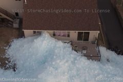
Imagine coming home from work and seeing 20 feet of ice in your back yard or even worse, part of your home smashed in by an Ice Shove or Ice Tsunami.
With winds gusting to over forty miles per hour this afternoon, the remaining large ice field that had yet to melt on Mille Lacs Lake was pushed on the eastern shoreline like a massive Ice Tsunami or Ice Shove.
When the ice on Mille Lacs Lake starts to move in high winds, it is basically similar to a Glacier moving and will not stop until it crashes on shore and into anything in its path which will be pushed out of the way including large boulders and tracks of land and even a house.
Mille Lacs Lake is a large lake that is over 200 square miles and is about 100 miles north of Minneapolis, MN.
Footage includes ground B-Roll, Drone B-Roll and clips from inside the house with the home owner.
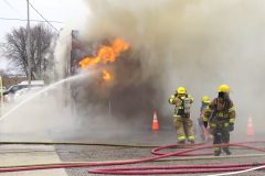
Just before 9:00 this morning a are fire was reported at The Ultimate Sports Bar in Waite Park, MN and turned into a Five Alarm Fire.
Fire crews from Waite Park, Saint Joseph, Saint Cloud, Sartell, and Rockville responded to a blaze at the Ultimate Sports Bar and Grill which is preliminary being reported a total loss.
There was no word on injuries and the cause of the fire is currently under investigation by local authorities along with the State Fire Marshal has been called in to help with determining the cause of the fire.
Ironically the fire was only about 1,000 feet away from the Waite Park Fire Department and City Hall. The fire was on 11th Avenue and the Fire Department is located on 13th Avenue.
*EDIT* Please don’t just to ARSON in the comments without first letting the State Fire Marshall conduct an investigation. Four years ago we did another video at the same spot where high winds knocked down electrical wires right above it. It is way too early to speculate on a cause considering there was massive power arcs right it the last time wind knocked down a power line https://youtu.be/EGCwL9Lzodg
Shot Description
Clip 1 Long shot of the fire down the street with a fire fighter manning a hydrant.
Clip 2 Flames and smoke as the building is on fire with a fire truck next to it and crews attacking the fire.
Clip 3 Pan down shot of the Waite Park ladder truck pouring water on the building as the fire rages and crews on the ground are trying to put the fire out.
Clip 4 Wide shot of the fire and heavy smoke as fire fighters battle the flames.
Clip 5 Tight shot of fire fighters battling the flames.
Clip 6 – 9 Drone footage over the scene as flames and thick smoke fill the area.
Clip 10 Tight shot of fire crews battle the fire.
Clip 11 Fire crews fighting the fire.
Clip 12 Intense thick smoke as fire crews try to fight the fire from the west side of the building.
Clip 13 Tight shot of crews in the intense thick smoke.
Clip 14 Heavy thick smoke as fire crews battle the scene while another watches the scene from the edge to keep an eye on everything.
Clip 15 Tight shot of the crews battling the fire.
Clip 16 Wide show of the scene from Division or County Road 75.
Clip 17 Medium shot of the scene from County Road 75.
Clip 18 Looking up at the bucket truck as crews pour water on the scene.
Clip 19 Crews cut a hole into the side of the building to access the fire in the walls and ceiling.
Clip 20 Crews battling the fire from the front of the building.
Clip 21 Fight fighter looks over the scene from atop a ladder truck.
Clip 22 – 27 Side of vehicle shots showing all the fire crews and police that where on scene.
Clip 28 Police line tape with fire trucks.
Clip 29 Tight shot that shows the Waite Park City Hall, Police and Fire department and pan right to show just how far away the structure fire was to the fire department less then 1,000 feet or 350 meters away. They actually ran water from the fire hydrant outside of the fire department to the scene.
Clip 30 Water from the scene flowing into a drain down the street from the scene.
Clip 31 Heavy construction equipment was brought in to remove hazards from the room and help ventilate the scenes.
Clip 32 Drone shot of the fire breaking through the roof on the north side of the building as the back hoe is trying to ventilate the roof and remove heavy objects like air conditioning and satellite antennas.
Clip 33 – 34 Drone shot of the back hoe removing more objects from the roof.
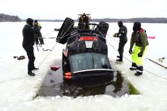
With everyone Social Distancing and now many locations issuing Shelter In Place, some in the northern states might be tempted to get in one last day of Ice Fishing. Here is a warning, please don’t because it may cost you your life or your very expensive out door equipment along with the cost of thousands of dollars to recovery your vehicle if it falls through the thin ice.
Footage shot during the mid afternoon 3/25 on Ann Lake in Ann Lake Township, MN of the staff of Andy’s Towing out of Saint Cloud, MN recovering a Polaris Side By Side ATV.
According to the crew recovering the ATV, a Grandfather and two Grand Children where out Ice Fishing and drove into an area of thin ice. All three where able to make it out of the ATV unharmed and make it to shore for help on 3/24/2020.
The ATV fell into about 14 feet deep water in near zero visibility due to a current from a nearby river that feeds the lake.
Shot Description
Clip 1 Drone shot showing the tracks of the ATV as it drove over the thin ice over the river channel in Ann Lake.
Clip 2 Scuba Tank B-Roll
Clip 3 Interview with Josh Athmann of Andy’s Towing and he describes the scene and what is happened.
Clip 4 B-Roll of the tracks of the ATV up to the open water.
Clip 5-6 B-Roll of Andy’s Towing vehicles.
Clip 7 Tracked recovery vehicle driving on the ice.
Clip 8 Dive crew gearing up.
Clip 9 – 11 Crews cutting a hole in the ice about 150 feet away from where the vehicle went in to drag it under the ice and lift it out at an area where the ice is stronger.
Clip 12 Dive crew getting ready to go into the water.
Clip 13 Drone pull back shot starting out with a tight shot of a diver ready to enter the water and then fly away to wide shot to show the whole scene.
Clip 14 – 15 Diver enter the water.
Clip 16 Diver in the water monitoring a second diver under the water directly below him.
Clip 17 Both drivers in the water after hooking up a cable to the ATV.
Clip 18 Tight wide shot on the winch pulling the ATV out then pans right to the A Frame rig used to lift the vehicle out of the water.
Clip 19 – 23 Pulling the ATV out of the water and back up onto the ice.
Clip 24 – 25 ATV on the ice after it was recovered.
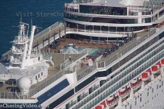
Cruise ships look like “ghost ships” as they depart Miami without passengers during one of the biggest cruise weekends of spring break season. The COVID-19 pandemic has forced the cruise industry in Miami to suspend passenger cruises for at least 30 days in an attempt to slow the contagion of the coronavirus by fostering social distancing. Erie rare video of cruise ships leaving the Port of Miami without passengers. Coronavirus ghost ships.
Shot Description
12,3) Shots of Norwegian Pearl departing the port of Miami cruise terminal without cruise passengers and heading to the turning basin to turn around before heading out to sea.
4) Close long duration shot showing the upper deck void of passengers as Norwegian Pearl approaches the turning basin.
5,6) Two shots of upper deck areas completely empty as the ship turns in the basin.
7,8) Upper deck basketball court empty.
9,10) Stern dining area empty except for 3 officers in white uniforms.
11) Duplicate shot of #9. Oops.
12,13) Norwegian Pearl heading out towards the Government Cut.
14-19) Six varied shots of the ship Explorer of the Seas leaving the dock in ghost ship mode and heading out to sea without any passengers.