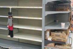
Shelves usually full of canned goods, toilet paper, and other supplies are as employees try to keep up with demand on March 14, 2020 at Walmarts across Colorado Springs, Colorado. On March 13, 2020 President Trump declared a national emergency over the Coronavirus, Covid-19 after the W.H.O. declared it a pandemic.
Shot Description
0:00 – An isle normally filled with toilet paper and paper towels is mostly empty at Walmart
0:17 – Mostly empty shelves usually containing pasta and pasta sauce
0:32 – Another shot of empty shelves usually containing pasta and rice
0:41 – Closeup of empty shelf usually containing canned goods
0:49 – A note asks customers to limit purchasing of Babywipe products
1:06 – Empty shelves of hand soap
1:24 – Closeup of Empty shelves of hand soap
1:31 – Shoppers pick out items near an empty shelf
1:51 – Shoppers shopping
2:05 – Empty meat shelves
2:17 – Empty shelves normally stocked with eggs
2:29 – Closeup of empty shelves normally stocked with eggs
2:40 – More empty egg shelves
2:46 – Walmart employee tidy’s up egg shelf with limited stock
2:51 – Empty toilet paper and paper tower shelves
3:01 – Closeup of empty toilet paper shelf
3:10 – Near-empty meat isle
3:25 – Hand sanitizing station
3:35 – Closeup of hand sanitizing station
3:40 – Shoppers exiting Walmart in Colorado Springs
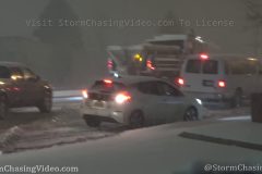
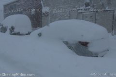
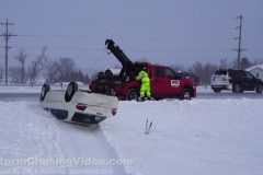
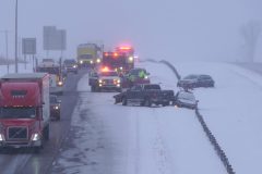
Dateline: 3/1/2020 – Cars Spin and Drift During Sudden Heavy Snowfall in Colorado Springs, CO.
To License This Footage, Contact Desk@NewsVideoNetwork.com
A sudden dump of intense heavy and wet snow creates slippery conditions on March 1, 2020 causing traffic mayhem in Colorado Springs, Colorado.
Shot Description
00:00 – SUV loses control and runs into a traffic barrel
00:13 – Another SUV loses control slams into a curb, and drives off
0:28 – Cars stranded driving uphill on N. Union Blvd
00:50 – Snowplow on N. Union Blvd while cars trail behind
01:11 – Police close eastbound E. Woodman Rd to clear stranded cars uphill (traffic jam)
01:31 – A cars struggle up a slippery hill at N. Union Blvd, causing mayhem
03:41 – Snowplow plowing and treating road
04:00 – Truck with trailer slides on N. Union Blvd
04:14 – Cars travel up W. Fillmore St in heavy snow
04:27 – Police direct traffic away from a hilly closed portion of N. Union Blvd
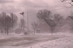
Powerful winds from an intense low pressure system create ground blizzard conditions and rough surf along the eastern shores of Lake Ontario in Jefferson County, NY.
Shot Description
Shots 1-8: Powerful winds create near whiteout ground blizzard conditions in the town of Sackets Harbor, NY.
Shots 9-13: Waves crash over large mounds of ice along the eastern shores of Lake Ontario at Southwick Beach State Park.
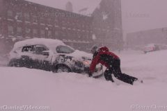
A powerful storm system brought intense snow and strong winds to the Watertown NY area. Numerous vehicles became stuck in the deep snow, and residents helped each other get them free.
Shot Description
SHOT 1: Two people push a stuck vehicle out of a deep snow bank.
SHOT 2: A large tow truck pulls a vehicle free from a deep snow bank.
SHOT 3: A person pushed a stuck vehicle out of a snow bank and back onto the road.
SHOT 4: A person helps to push a vehicle free.
SHOT 5: A vehicle becomes even more stuck in the snow.
SHOT 6 & 7: A large snow plow passes by the camera in deep snow.
SHOT 8: A police officer directs traffic in the middle of blinding snowfall.
SHOT 9: A person walks up a snowy sidewalk and loses his balance on the ice, nearly falling.
SHOT 10: People clear a sidewalk from nearly 2 feet of snow.
SHOT 11 & 12: A man uses a snowblower to clear the deep snow from his driveway.
SHOT 13: Driving by houses buried in deep snow.
SHOT 14: A man uses a snowblower amidst heavy falling snow.
SHOT 15: Traffic lined up in heavy falling snow.
SHOT 16: A man shoveling snow off the sidewalk.
SHOT 17: Two people walk by in yellow jackets during heavy snow.
SHOT 18: Panning shot of the statue in downtown Watertown, NY during intense snow.
A powerful low pressure system creates intense lake effect snow bands, bringing whiteout blizzard conditions to Jefferson County, NY.
Shot List:
Shots 1-2: Motorists stuck in deep snow in their vehicles
Shot 3: A man with a cane struggles in very deep snow as he attempts to climb over snow drifts
Shot 4: Vehicles buried under several feet of snow
Shots 5-6: Pedestrians are barely visible as they walk in whiteout blizzard conditions in Jefferson County, NY
Shot 7: A man uses a snow blower to clear a sidewalk in blizzard conditions in Watertown, NY
Shots 8-9: Pedestrians are barely visible as they walk in whiteout blizzard conditions in Jefferson County, NY
Shot 10: A lady spins the tires on her vehicle as she tries to get her vehicle out of very deep snow in Jefferson County, NY
Shot 11: Several good Samaritans push a vehicle out of very deep snow in Jefferson County, NY
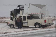
A major winter storm dumped over a foot of snow to parts of central Kansas on Tuesday with many areas seeing the highest snowfall of the season. Two fatalities were blamed on the storm here in Kansas.
Video package shot in western Marion County near Hillsboro, Kansas, which is roughly an hour north of Wichita.
Shot Description
Clip 1-2: Shots of crazy intense, heavy falling snow.
Clip 3: White truck stuck in the snow off on the side of US-56.
Clip 4: Woman driving the stuck pickup truck gets into another truck of someone who came by to help her.
Clip 5: Man walking around the stuck pickup looking for a place to hook on.
Clip 6-7: Man bringing strap to other pickup truck, then running back to get into stuck pickup.
Clip 8: One truck pulls the other free of the snow.
Clip 9: Another crash scene, this with a red tow truck on scene of a spin-out.
Clip 10: Tight shot of gold car spun off the highway.
Clip 11-12: Wide and tight shots of crash scene from behind the tow truck.
Clip 13-14: Silver car well off the highway in the snow.
Clip 15-16: POV driving shots in very heavy falling snow passing several cars and a couple of school buses.
Clip 17: Two school buses driving through the heavy falling snow.
Clip 18-19: Heavy snow falling on parked school buses.
Clip 20: Wide shot of heavy snow falling in town.
REMAINING CLIPS EARLY AFTERNOON AS SNOW CEASED NEAR LINDSBORG, KANSAS – AFTERMATH AND RECOVERY CLIPS
Clip 21: Wide shot of a damage blue pickup truck off the embankment of I-135 with two two trucks up on the hill along the interstate.
Clip 22: Bull-dozer stuck in the snow and mud during the recovery effort to get the blue pickup truck out.
Clip 23: Two truck driver closing the driver-side door of the pickup truck.
Clip 24: Shot of blue pickup truck with bulldozer trying to get out of the mud behind it.
Clip 25: Tight shot of stuck bulldozer rocking back and forth in the mud.
Clip 26: Another crash scene of a red pickup that was towing a white van stuck in the ditch off I-135 with tow truck on scene.
Clip 27: Tighter shot of red pickup and white van.
Clip 28: Shot of crash scene from behind which also shows another white van further up the road in the ditch.
Clip 29: Shot of man walking beside stuck trailer with the other white van behind him.
Clip 30: Shot of two people next to tow truck with other white van in the background.
Clip 31: Wide shot of other white van stuck in snow off I-135.
Clip 32: Shot of a tow truck on scene next to stranded semi truck in median of I-135.
Clip 33: Tighter shot of stranded semi in the median.
Clip 34-35: Tow truck driver dragging line from the tow truck to the semi.
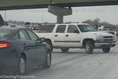
Snow and ice lead to a nightmare morning commute as dozen of accidents occurred across Wichita-area highways leading to the closure of several major routes in the city for several hours during the morning. Cars were scattered all over the area as many slid off roads and crashed. Snow totals were less than 2-inches in the city, but the ice made for an extremely hazardous commute.
Shot Description
Clip 1: White SUV trying to get traction near a crash scene slides sideways in front of the camera right on I-235.
Clip 2: White SUV gathering itself and turning straight down I-235.
Clips 3-4: The two car crash involving a pickup truck and a black car in the median of I-235 where the SUV slid sideways in previous clips.
Clips 5-6: POV windshield shots of white pickup truck spinning tires trying to get up a hill.
Clip 7: POV windshield shot as camera person drives car and gently nudges the truck from behind to help it get up the hill.
Clip 8-11: Shots of vehicles struggling to get up an icy hill near I-235 in west Wichita. Shots include tight shots of cars spinning tires along with wider views as multiple vehicles are struggling or stuck.
Clips 12-14: Pickup truck crashed into the trees in the median of I-235 and K-96.
Clips 15-17: Police SUV and tow truck at scene of a single vehicle crash involving a blue pickup truck off the side of I-235.
Clips 18-22: Two vehicle crash involving a church bus and a gold car at the base of an off-ramp from I-235.
Clips 23-27: Shots of a tow truck pulling a white utility truck up a hill out of the median from SB I-235.
Clips 28-29: Black pickup truck spun 180-degrees off the side of SB I-235.
Clips 30-31: A white car and a FedEx semi stuck on ice on the ramp from eastbound US-54 to NB I-235.
Clips 32-34: Backup on the ramp with a police officer showing up and walking car-to-car behind the FedEx truck and white car.
Clips 35-36: K-DOT sign warning drivers of icy bridges and ramps.
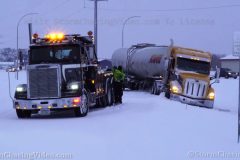
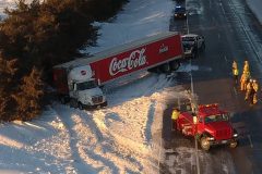
A powerful burst of snow and freezing rain hit Interstate 94 in eastern Stearns County, MN creating a very slick driving conditions with snow and ice compacting to the road surfaces. Several accidents created gridlock on the interstate for about an hour as crews worked to clear the wrecks.
Shot List:
Scene 1 Snow plow on Interstate 94.
Scene 2 Four clips of a Semi Truck being pulled out of a ditch along Interstate 94.
Scene 3 POV Driving in slow traffic on Interstate 94 with about a inch of ice covering the road surface.
Scene 4 Three clips of several Semi Trucks and other vehicles crashed on eastbound Interstate 94 just south of St Cloud, MN.
Scene 5 POV passing shot of a crash on County Road 75 just south of St Cloud, MN
Scene 6 POV passing shot of snow plow on Interstate 94.
Scene 7 Wide ground shot of snow plows in St Cloud passing and throwing snow at the camera.
The heaviest snow of the season fell in Wichita Wednesday afternoon, peaking out during the morning rush hour. Snow was still falling at the time of upload, but over 2-inches have been reported in various places across Greater Wichita. Fortunately mild temps leading into this storm kept roads mostly wet, but the snow was enough to cause some wrecks and very slow traffic during the morning rush. A WINTER WEATHER ADVISORY remains in effect until midnight tonight as more snow and potential flash freezing is possible into the evening and overnight.
Shot Description
Scenes 1-7: Various clips of a multi-car wreck in the clean-up stages near Seneca and I-235. Tow truck has a severely damaged vehicle on the bed and cops have the right lane on Seneca blocked off with two other damaged cars.
Scenes 8-10: Shots of a tan car slide off from I-135 as interstate traffic passes behind it.
Scenes 11-15: Shots of a black car slide-off from I-135 in north Wichita.
Scenes 16-17: Tow truck takes damaged vehicle from crash sight off I-135 in Wichita.
Scene 18-22: Various close shots of snowplows clearing snow from I-135.
Scene 23: POV driving shot of a snowplow.
Scene 24: POV driving shot of a long line of traffic on K-96 in north Wichita.
Scene 25-27: POV driving shots of traffic in very heavy snow.
Scene 28: School busses and other cars on the roadways in very heavy falling snow.
Scene 29-32: Various shots of vehicles driving through the heavy falling snow.
Scene 33-35: Scenic falling snow clips.
A fast and powerful winter storm hit the southern part of Minnesota including the southern Twin Cities metro area.
Shot Description
0.00 State plow on road in New Prague
17.00 Semi tractor off road on I-35 in Northfield,
53.00 small snowblower in New Prague,
01.04.00 three city plows plowing snow in Burnsville,
01.14.00 old plow truck on farm in New Prague,
01.21.00 tracked bobcat plowing snow around stuck old plow truck on farm in New Prague, MN.
Heavy snow and ice cause widespread accidents and treacherous travel conditions in Syracuse, NY from a powerful ‘Bombcyclone’ hitting the region.
All footage shot during morning daylight hours in Syracuse, NY by meteorologist Simon Brewer
Shot Description
1-15. various shots of multiple accidents from cars sliding into each other or off roads and highways, some with emergency assistance in Syracuse, NY
16-22. various shots of pedestrians and traffic navigate treacherous conditions in downtown Syracuse, NY with low visibility, heavy snow falling, on snow and ice-covered roads
23. snow plow clearing ice and snow from highway in Syracuse NY
24. traffic passing highway sign warning of winter storm in Syracuse NY
25. traffic in very heavy snow on highway in Syracuse NY
A major winter storm brought some of the highest snow totals seen in years across portions of southwest Kansas. Reports included totals over a foot deep in areas while many locations saw double-digit totals. Heavy snow started overnight Monday into Tuesday and continued into the afternoon closing roads and causing travel headaches across the region. Winter Storm Warnings were in effect through the day on Tuesday across the region.
Video divided into two parts, the first from Greensburg and the second part from Minneola, Kansas.
Shot Description
PART 1 (00:00-03:22) GREENSBURG, KANSAS – KIOWA COUNTY
Scene 1: Police at the closure of US-400 on the west side of Greensburg.
Scene 2: Police telling person in RV about closure, while audio is low, you can hear the cop tell the RV people that it is slow going.
Scene 3-6: Various shots of closure with police on scene.
Scene 7-9: Shots of US-400 closure on east side of Greensburg, closed all the way to Pratt.
Scene 10: Snow plow clearing snow from US-400 west of Greensburg.
Scene 11-13: POV driving shots behind plow on US-400 eastbound toward Greensburg.
Scene 14-16: Shots of a semi that slid off the highway west of Greensburg.
Scene 17: Two trucks driving slowly through very heavy falling snow.
Scene 18: POV driving shot in very low visibility and slow traffic.
Scene 19-21: Various clips of extremely heavy falling snow on west side of Greensburg.
PART 2 (03:22-6:04) MINNEOLA, KANSAS – CLARK COUNTY
25 miles south of Dodge City on US-283
Scenes 22-26: Various angles of a semi stuck in snow on a neighborhood street. It is blocking the road.
Scene 27: Black car stuck in snow drift with stuck semi in background looking for street.
Scene 28-29: Red semi stuck in snow.
Scene 30-31: Snow plow clearing US-283 through town.
Scene 32: White pickup truck navigating snow covered streets.
Scene 33-35: Person walking down the middle of a snow covered street.
Scene 36: Man walking down snow covered street.
Scene 37: Cool shot of wind farm spinning in heavy snow.
What a crazy day on the roads in Minnesota. Lost track of the number of accidents & roll overs. This tow truck driver near Avon was not having a good day… 25 minutes of raw video into 90 seconds of Benny Hill like comedy. Drive Safe
Music by http://toolofgod.com/my-music/royalty-free-benny-hill-theme-style-alternative/
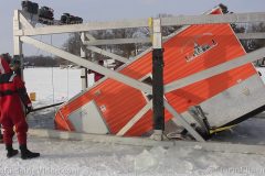
The ice castle that went through the ice back on January 4th, along with the ice recovery equipment. The ice castle was recovered today. The crew had to wait for better ice conditions to recovery the ice castle. The vehicle extraction equipment was recovered last Thursday. I was unable to be there for that. However I was there for the first attempt on Monday January 6th. That didn’t go as planed as the ice conditions still weren’t good enough.
This video package will show the ice castle’s recovery. Towards the end of the video. It will show a small part of the prep and the attempt to recovery their equipment.
Shot Description
Clip 1. Shows just a small part of the roof of the ice castle sticking up through the ice.
Clip 2. The crew cutting the ice out of the way.
Clip 3. Air pockets still coming up from the ice castle.
Clips 4-5. The crew pushing and pulling the ice castle to the recovery rig.
Clip 6. The crew hooking up the cables to the backside of the ice castle.
Clip 7. The crew slowly lifting the backside of the ice castle.
Clips 8-12. The crew pulling the ice castle out of the water onto better ice.
Clip 13. Britt holding a sign that should be on the rig, however they haven’t had time to reattach it.
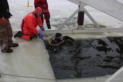
Clips 14-15. Brad getting ready for his dive into the icy waters to unhook the ice castle from the recovery rig.
Clip 16. Brad going into the water than under the ice.
Clip 17. Brad coming out of the water.
Clip 18. Crew trying to pull their rig onto better ice, however the ice kept breaking away. The recovery of their rig was put on hold.
Clip 19. Some other equipment the crew uses during the recoveries, if needed.
With winds gusting up to 49MPH and sustained winds near 30MPH the blowing and drifting snow over the roadways in rural Stearns County made for slippery driving conditions today.
The snow blew over the roadways that warmed up in the in the midday sun and then refroze as Glaze Ice and then had more ice and snow build up on top to create extremely dangerous driving conditions in the high winds.
Footage of the blowing snow and numerous accidents around southeastern Stearns County on Highway 23 and Highway 15.
Shot Description
* First part of the video shot just north of Paynesville, MN *
Clip 1 Blowing and drifting snow over a road.
Clip 2 POV Drive By of a Jack Knifed Semi Truck on Highway 23.
Clip 3 – 7 Drone footage of the Jack Knifed Semi Truck on Highway 23.
Clip 8 Tow truck arriving on scene for the Jack Knifed Semi.
Clip 9 – 12 Various recovery shots of the Jack Knifed Semi Truck.
* Second part of the video was shot on Highway 15 near Kimbal, MN *
Clip 13 Blowing and drifting snow on Highway 15.
Clip 14 Snow plow on Highway 15.
Clip 15 Vehicle in the ditch in the blowing snow on Highway 15.
Clip 16 American Flag blowing in the clear blue sky.
Clip 17 Vehicle in the ditch and town truck with a plow truck driving past the scene.
Clip 18 Tow truck driver shoveling out the car in the ditch.
Clip 19 POV clip of a wreck on Highway 15.
Clip 20 Blowing snow over a snow drift with tree’s in the back ground.
Clip 21 Blowing snow and a stop sign with the blowing snow drifting.
Clip 22 Blowing and drifting snow over a open field.
Clip 23 Blowing and drifting snow with a long orange snow fence causing the snow to pile up along the side of the road in the field.
Clip 24 POV Driving in blowing snow over the road making everything look white.
Clip 25 Following slow moving traffic with the blowing snow over the Highway.
Clip 26 – 29 Various shots of snow plows.
A side by side went through Pokegama Lake right before Christmas. No one was injured. This video package shows the recovery of the side by side. One clip shows how the ice is layered this year. I never seen the ice layered like this in all my years on the ice. The ice on area lakes aren’t safe.
Shot Description
Clip 1. The recovery team setting up their equipment for the recovery.
Clips 2-3. Britt cutting a hole in the weak ice.
Clip 4. Miles showing us how the ice is layered.
Clips 5-6. A diver getting ready for his dive.
Clips 7-8. The diver going into the water.
Clips 9-12. The side by side being pulled from the icy waters.
Clip 13. The crew pulling the rig and side by side with snowmobiles to safer ice.
Clip 14. The side by side is on safer ice.
Clip 15. The crew pulling the recovery equipment from the are back to the boat landing.
SID: Dirk Miller
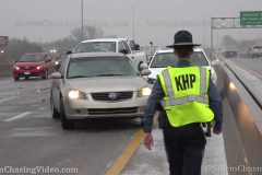
Icy roads are to blame for at least one fatal crash in Wichita Sunday morning as more than two dozen crashes were reported in less than two hours on city highways as freezing rain moved in late in the morning. Crashes closed several highways and exits as crews cleaned up the wrecks left behind from the icy conditions.
One of the fatal crashes occurred on the north side of the city at I-135/I-235. That area was shut down for a couple hours.
Video package shot in Wichita documenting numerous icy road crashes along I-235 and US-400.
Shot Description
Scene 1: POV driving shot passing a four-car crash on westbound Kellogg/US-400.
Scene 2: Looking back at four-car crash with KHP trooper walking toward the cars.
Scene 3: Tight shot of severely damaged blue car as part of the four-car crash.
Scene 4: Wider shot of four-car crash with KHP on scene.
Scene 5: Shot looking back at four-car wreck.
Scene 6: Spin out crash at the US-400/I-235 junction with police on scene.
Scene 7: POV driving shot passing another multi-car wreck on US-400.
Scene 8: Shot looking back at white pickup truck as part of another multi-car wreck. White truck was blocking two lanes.
Scene 9: Tighter shot of severely damaged spun-out white truck.
Scene 10: POV driving shot approaching another multi-car wreck on eastbound US-400.
Scene 11-12: POV driving shot passing multi-car wreck with orange sideways car.
Scene 13: POV driving shot passing through an accident scene in clean-up stages.
Scene 14-15: Shot looking at semi truck stuck on the ramp from I-235 to K-96.
Scene 16: K-DOT crew member directing traffic away from closed exit ramp to K-96 from I-235.
Scene 17-18: K-DOT crews at the closure of US-400/Kellogg at Maize road in west Wichita with large accident in the background.
Scene 19-20: Police blocking eastbound Kellogg at Tyler.
Scene 21: POV driving shot in freezing drizzle with K-DOT sign warning of bad weather conditions.
Scene 22-23: Shots of K-DOT highway sign warning of hazardous travel on I-235.
SID: Tornadoes Kick Media
Another round of snow combined with near zero temps created extremely slick road conditions on Interstate 94 in Stearns County, MN that resulted in several areas of multiple vehicle piles ups.
Shot Description
Clip 1 Pile up with multiple vehicles on Interstate 94 near Saint Johns University.
Clip 2 Snow plows drive by a crash on Interstate 94 with State Patrol on the scene.
Clip 3 Two vehicles crashed on Interstate 94.
Clip 4 Tow truck recovering a red car that was involved in the pile up near Saint Johns University.
Clip 5 Several emergency vehicles on the scene with crashed vehicles.
Clip 6-7 Tight shot of a MN State Patrol SUV and a SUV in the center ditch.
Clip 8-9 Crashed Dodge Durango with the front end smashed in.
Clip 10 Snow Plows
Clip 11 Tight shot passing snow plow and plow blade.
Clip 12 POV passing a truck that rolled over on i-94.
Clip 13-18 POV drive by of several vehicles involved in a pile up near Opportunity Drive on Interstate 94.
Clip 19 Smashed pickup being recovered.
Clip 20-23 Several vehicles being recovered near Opportunity Drive on I-94
Clip 24-28 Various tight and wide shots of snow plows on Interstate 94.
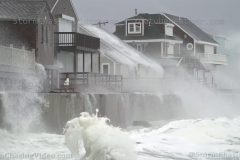
Powerful Nor’easter slams coastal New England with high winds, massive waves, and flooding storm surge.
All footage shot during afternoon daylight on December 2, 2019 in/near Scituate, MA by Meteorologist Simon Brewer.
Shot Description
1-17. various shots of massive damaging waves and storm surge flooding Scituate, MA
18. American Flag blowing in high winds in Scituate, MA
19-21. shots of giant Christmas wreath on Scituate Lighthouse blowing in high winds
22. POV driving shot of high winds and heavy rain on highway traffic near Scituate, MA
SID: Simon Brewer
Powerful Nor’easter begins as an Ice Storm over Western Upstate New York causing dangerous road conditions with freezing rain, sleet and snow. Footage of accidents with law enforcement assistance, and various ice storm shots.
All footage shot in/near Hornell, NY during morning daylight hours on December 1, 2019 by Meteorologist Simon Brewer
Shot Description
1. “Freezing Rain” electronic highway warning sign with freezing rain falling
2-8. various shots of accidents from cars losing control on ice-covered highway (I-86) near Hornell, NY
9-12. various shots of traffic, including police cruiser, on ice-covered highway (I-86) near Hornell, NY
13-16. various POV driving shots of traffic driving slowly on ice-covered highway (I-86) near Hornell, NY
17-19. various shots of sleet pellets accumulating in Hornell, NY
20 & 21. shots of salt solution spread on highway to combat freezing rain and sleet by snow plows/salt trucks
22. front loader clearing ice from market parking lot in Hornell, NY
SID: 77
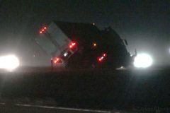
Extremely high winds tip over a semi truck and trailer creating hazardous driving conditions Nov. 30, 2019 in Colorado Springs, Colorado.
Shot Description
00:00 – Semi truck as it travels southbound I-25 north of N. Academy Blvd. tipping over.
00:31 – Wide if crews responding to previously mentioned semi incident
00:36 – Mid of crews responding to previously mentioned semi incident
00:41 – Close of crews responding to previously mentioned semi incident
00:50 – Police officer removes blown over construction side from road during extreme wind
01:03 – Wide of winds whipping road where police officer’s vehicle is parked
01:09 – Police officer returns to vehicle as winds increase while being pelted by debris
01:24 – Nearby intersection in extreme winds with flying debris and swaying stoplights
01:30 – Cars waiting at intersection while being pelted by windswept debris
01:39 – vehicles leaving gas station while debris fly by
01:52 – Wide of American Flag being battered by wind
02:05 – Close of American Flag being battered by wind
02:13 – Van waiting at intersection as stoplight sways
02:18 – Stoplight swaying in wind
02:24 – Street sign swaying in wind
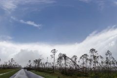
The only complete Documentary about the historic Hurricane Michael documenting the destruction of eastern Bay County, FL from Panama City to Mexico Beach, FL on 10/10/2019.
To help support our freelancers, buy them coffee. https://www.buymeacoffee.com/stormchasing
Unlike others Hurricane’s such as Hurricane Katrina, Andrew, Rita, Ivan and even Hurricane Sandy that have become household names, within a week after Hurricane Michael the storm and the people impacted by storm where all but forgotten about by the rest of the country and in the media for flooding in Texas and wildfires in California.
Hurricane Michael made landfall near Mexico Beach on October 10, 2018, with maximum sustained winds of 160 miles per hour or 260 km/h.
Hurricane Michael was the first Category 5 hurricane to make landfall in the United States since Hurricane Andrew in 1992.
Michael made history as the third strongest storm by pressure and fourth strongest by wind speed to make landfall in the continental United States.
The storm caused extensive damage from Panama City, Tyndall Air Force Base and Mexico Beach and further east into Gulf County.
Nearly all homes were totally destroyed within Mexico Beach.
Special Thank You (In No Specific Order)
Tony Brite
Chris Collura
Brian Dombrowski
Simon Brewer
Juston Drake
Mark Sudduth – Hurricane Track
Derek Sibley
Tim Millar – Cyclone Research Group
Sherrell Morrison
Chris Hester & Karen Gabriel
Joey Krastel
Olivier Staiger
Dave Lewison
Sherrell Morrison
NOAA – National Weather Service
National Hurricane Center
University Of Wisconsin
The people of Bay County, FL
Neva Andersen & Laura Kiesling
And the StormChasingVideo.com LLC Crew
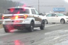
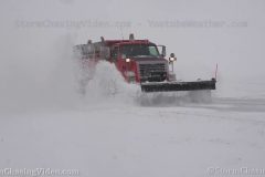
Blizzard conditions continued to hammer northwest Kansas leading to the closure of numerous highways, including I-70, US-36, US-40, and KS-27. Near whiteout conditions combined with icy roads lead to the closures. Up to a half a foot of snow has already fallen in the region with more expected through the evening.
As of 2:00pm, I-70 was closed from Colby, Kansas west all the way to Denver, Colorado.
Shot Description
Scene 1: SOT from Kansas State Trooper Austin Ackerman talking about the conditions along I-70 and why they closed it.
0:32-1:30 COLBY, KANSAS (Thomas County)
Scene 2-5: Shots of two KS State Troopers sitting at the Colby exit with the gates down.
Scene 6: Shot of traffic exiting at the Colby closure.
Scene 7: Shot of highway sign telling motorists to exit I-70.
Scene 8: Panning shot of snowplow on I-70.
Scene 9: POV driving shot of the hazardous conditions along I-70 between Levant and Colby.
1:30-3:53 GOODLAND, KANSAS (Sherman County)
Scene 10: Nearly whiteout conditions in Goodland along I-70 at the closure at exit 17.
Scene 11: Shot looking over the gate at Trooper sitting at Goodland exit.
Scene 12-13: Shots of trooper and closure gates along I-70 at Goodland.
Scene 14: Shot of trooper on I-70 in very heavy falling snow.
Scene 15-17: Traffic exiting westbound I-70 at Goodland.
Scene 18: Wide shot of I-70 closure.
Scene 19-20: Snowplows on K-27 in Goodland in very heavy snow.
Scene 21-22: Shots of traffic in near whiteout conditions along K-27 in Goodland.
Scene 23: Near whiteout conditions hiding grain elevators in Goodland.
Scene 24-25: Shots of very heavy snow falling against trees.
3:53-5:12 ST. FRANCIS, KANSAS (Cheyenne County)
Scene 26-27: Shots of K-DOT sign warning drivers that US-36 is closed west of St. Francis due to the blizzard.
Scene 28-29: Shots of the US-36 closure.
Scene 30: State trooper sitting along US-36.
Scene 31: Trooper driving into the snow, vanishing from sight.
Scene 32-33: POV driving shots along US-36 in near whiteout conditions.
Scene 34: Looking west along US-36 with near whiteout conditions.
SID: Tornadoes Kick Media
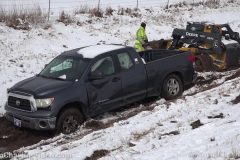
Snow began to fall just after 3am across the high plains as a major winter storm and blizzard moved off the Rockies. Significant snowfall and icing conditions closed numerous roads in Colorado, including I-70 from the Kansas border all the way to Denver. Icy conditions on the Kansas side of the border lead to a crash in the median of I-70 west of Goodland.
Shot Description
Scene 1: Shot of Kansas State Trooper at the scene of a jack-knifed pickup truck in the median of I-70 near Mile Marker 11, about six miles west of Goodland, Kansas.
Scene 2: Driver who was unhurt checking the damage to the passenger side of the truck where his trailer crushed the door and smashed out the windows.
Scene 3: Shot of the trailer lodged into the passenger side of the truck.
Scene 4: Wide shot of the jack-knifed truck in the median.
Scene 5: Shot of the driver standing outside his truck on his phone with the heavy damage to the passenger side of the truck.
Scene 6: Wide shot of the crash scene with the state trooper.
Scene 7-8: Shots of K-DOT highway sign warning drivers of icy and snowpacked conditions.
Scene 9-12: POV driving shots behind snowplows at various zooms as they clear I-70.
Scene 13-14: Looking down on I-70 from overpass as two snowplows clear eastbound lanes of I-70.
Scene 15: SHOT FROM BURLINGTON, COLORADO; shot of I-70 gates over the interstate as westbound I-70 was closed from here in Burlington all the way to Denver.
Scene 16-18: Various shots of gates over I-70 closed.
Scene 19-20: Traffic on westbound I-70 at Burlington driving by signs saying the interstate is closed just before sunrise.
SID: Tornadoes Kick Media