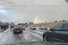
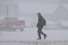
Footage of the hail storm that moved through the Phoenix, AZ metro area this afternoon that actually ended up accumulating on the roads and side walks.
Shot Description
Clip 1, hail storm starting as the hail begins to pickup in intensity.
Clip 2, Lots of hail falling and traffic driving through the hail.
Clip 3, White pickup truck parked under a tree to try and avoid the hail.
Clip 4, POV shot of the hail storm aftermath on Interstate 10 with hail piled up on the roadway in backed up traffic.
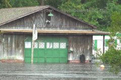
Storm surge from Hurricane Dorian strikes the community of East Lake, NC and large trees are down all over the region.
All footage shot in/near East Lake, NC during afternoon daylight on September 6, 2019 by meteorologist Simon Brewer
Shot Description
1-7. various shots of homes and vehicles in storm surge water from Hurricane Dorian in East Lake, NC
8. tractor trailer drives through storm surge flooding on highway in East Lake, NC as waters rise
9. waves hit bridge (normally too high) as storm surge rises near East Lake, NC
10. POV through rising storm surge water over highway in East Lake, NC
11-16. various shots of large trees downed by high winds on highway and over power-lines near East Lake, NC
17 & 18. bulldozer clears tree and tree debris from highway near East Lake, NC
19. pushed-in shot of police and emergency vehicles with closed causeway in background near East Lake, NC
SID: Simon Brewer
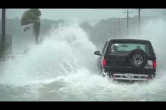
New footage from the tornado warned storm and storm surge in South Carolina today that is covering roadways as people were driving through the salt water.
Damaging storm surge and large waves flood Surfside Beach, SC as Hurricane Dorian passes beach community. Also shot of large rotating wall cloud from tornado-warned storm in feeder band of Hurricane Dorian near Conway, SC.
All footage shot during afternoon daylight on September 5, 2019 in Surfside Beach, SC by meteorologist Simon Brewer
Shot Description
1-5. various shots of large trucks attempting to drive through storm surge-flooded roads in Surfside Beach, SC
6-11. various shots of massive storm surge waves from Hurricane Dorian damaging homes, causing beach erosion and flooding in Surfside Beach, SC
12-16. various shots of storm surge flooding neighborhoods in Surfside Beach, SC
17 & 18. palms trees and homes lashed by fierce winds from Hurricane Dorian in Surfside Beach, SC
19. dock flooding from rising bay storm surge water in Surfside Beach, SC
20. young man checks on large crashing waves before storm surge floods Surfside Beach, SC
21 & 22. large rotating wall cloud from tornado-warned storm in feeder band of Hurricane Dorian near Conway, SC
SID: Simon Brewer
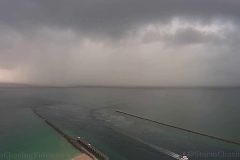
Time-lapse video from the Government Cut at the entrance to the port of Miami looking out east-southeast in the direction of looming Hurricane Dorian. Time-lapse starts at pre-sunrise through 10am showing multiple bands of ominous stormy squalls moving from east to west over the camera. 1080p 29.97 fps time-lapse video. No audio.
Shot Description
1) Time-lapse from pre-sunrise until 10am looking east towards Hurricane Dorian from the port of Miami from Continuum over the government cut. Multiple bands of ominous storms / squalls moving in from east to west over the camera. A cruise ship also comes inbound ahead of a squall at time-code 0:18.
SID: Broadwave com
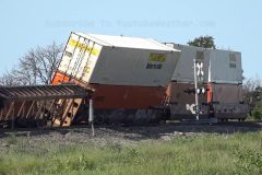
Overnight storms blasted across southeast Kansas with winds over 80mph and torrential rains. This massive line of storms started out as a couple of thundershowers near Colby in far northwest Kansas and evolved into a massive line responsible for damage and power outages across a large part of the state.
Here in Walton, two trains were derailed due to the strong winds around midnight Sunday morning. 90 cars were derailed on one train and 50 on another, making for 140 cars on two trains. This occurred 1 mile southwest of the town of Walton along US-50. Walton is a small town approximately 30 miles north of Wichita.
Crews reported on scene just after 5am and were working to clear the tracks through the morning into the afternoon. There is no word on when that area will reopen. Over a mile of track is blocked by the derailed train.
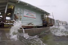
SW Florida remains soaked from on going heavy bands of rain moving in from the Gulf of Mexico. Blustery SW winds are also creating very choppy conditions on Sarasota Bay which is normally flat calm in the summer.
Shot Description
1) Traffic in rain splashes camera on US 41 in downtown Sarasota FL.
2) Dark tropical rain clouds moving in ready to dump heavy rain.
3) Tighter shot of low dark clouds moving.
4) Very heavy rain falls in residential neighborhood. Lamp post.
5) Tighter shot of lamp post with heavy rain.
6) Wind driven rain falls on pavement.
7) Wide shot of choppy seas on Sarasota Bay.
8,9) Low angle POV wet shots of chop coming over seawall.
10) Boat attempting to dock in choppy seas and rain. Waves coming over dock.
11,12,13) Three varied shots of flooded lawn and wooden fence from endless rain.
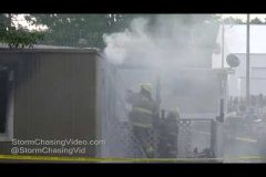
7/24/2019 12:33 AM Raw footage of the fire tonight in Paynesville, MN in a trailer park on Minnie Street where details are still being sorted out at this time and awaiting official word from the Stearns County Sheriffs office and the Minnesota Bureau of Criminal Apprehension (BCA).
Audio from our radio monitoring to provide more details which is pretty much all that is known at this time.
Update, 7/24/2019 Press Release from Stearns County.
Woman dies in Paynesville mobile home fire.
The Paynesville Police Department responded to a fire at 420 Minnie St, Trailer 20. Initial reports indicated a male was pouring gasoline inside the trailer and started it on fire.
Upon officers’ arrival, the trailer was fully engulfed. Fire fighters and officers learned an adult female was inside the trailer. The female was located inside the bathroom and life-saving measures were performed. She was transported to Paynesville Hospital where she was later pronounced dead.
A male party was arrested at the scene. He was transported to the St. Cloud Hospital for treatment of potential injuries and later transported to the Stearns County Jail.
The suspect is being held on charges of second-degree murder and awaiting his first court appearance. The body of the female was transported to the Midwest Medical Examiner’s Office for an autopsy. The Paynesville Police Department, Stearns County Sheriff’s Office, Minnesota Bureau of Criminal Apprehension, Minnesota State Fire Marshal Division and the Bureau of Alcohol, Tobacco and Firearms are investigating.
Paynesville Fire Department, CentraCare-Paynesville Ambulance, Cold Spring/Richmond Police Department, Belgrade Police Department, Minnesota State Patrol and Lake Henry Fire Department assisted at the scene.
Anyone with information regarding this incident is encouraged to contact the Stearns County Sheriff’s Office at 320-251-4240.
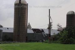
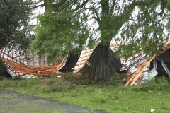
A tornado warned storm roared through Barron County this evening. This storm brought major damage along HWY 8 From Turtle Lake WI to Near Cameron WI. Other damage was noted in Cumberland and Chetek WI. Chetek was also hit hard from this storm. This storm did cause widespread damage throughout a good part of Barron County. Before the storm hit. The lightning put on a good show. This video package will mainly be the damage in Barron and along HWY8. The video will also show some of the lightning and the storms it’s self.
Shot Description
Clips 1-2. Damage in the city of Barron. Street lamp poles were downed along with many trees.
Clip 3. Yes that is a snow plow you see. The county had to use plows to clear some of the roads that are blocked by downed trees.
Clips 4-5. Damage on HWY 8 west of Barron. Downed trees and powerlines.
Clip 6. Damage on HW8 east of Barron.
Clip 7. Shed Damage north of the city of Barron.
Clip 8. Trees blocking the road.
Clip 9. People removing a tree that is blocking the road.
Clips 10 -11 The storm it’s self.
Clips 12 -15. CG lightning.
Clip 16. Heavy rain and strong winds. A street lamp pole blowing in the wind, along with the trees.
Clip 17. Heavy rain, strong winds, and hail hitting mu vehicle.
SID: Dirk Miller
On July 13, 2019, Category 1 Hurricane Barry produced significant impacts across much of Southern Louisiana. Particularly hard-hit was St. Mary Parish, where hurricane-force winds and storm surge flooding damaged buildings, toppled trees, and inundated roads in and around Morgan City.
Shot Description
1. Tight shot of high winds spraying water over rock retaining feature on Lake Palourde in Morgan City, LA
2. Medium shot of overspray from high winds over Lake Palourde in Morgan City
3. Medium shot of high winds and swollen Lake Palourde inundating a dock
4. Tight shot of trees bent over in hurricane-force winds in Morgan City
5. Wide shot of Flat Lake boat dock with strong winds in Morgan City
6. Medium shot of Flat Lake boat dock with strong winds in Morgan City
7. Wide shot of storm surge flooding inundating LA Highway 319 near Cypremont Point.
8. Medium shot of storm surge flooding inundating LA Highway 319.
9. Tight shot of storm surge flooding with debris flowing on LA Highway 319.
10. Medium shot of car submerged in storm surge on LA Highway 319.
11. Tight shot of car submerged in storm surge on LA Highway 319.
12. Wide shot of car attempting to escape rising floodwaters on LA Highway 319.
13. Medium shot of snake battling storm surge floodwaters to cross LA Highway 319.
14. Medium shot of local resident attempting to traverse floodwaters to return to his home near Cypremont Point.
15. Medium shot of local resident attempting to wade through waist-deep floodwaters to return to his home near Cypremont Point.
16. Medium shot of storm surge flooding and high winds along LA Highway 319.
17. Tight shot of storm surge flooding and high winds along LA Highway 319.
18. Medium shot of business closed and shuttered up due to Hurricane Barry in Morgan City.
19. Tight shot of sign showing local Morgan City business closed due to hurricane curfew.
20. Medium shot of Morgan City flood wall and swollen Atchafalaya River.
21. Medium shot of National Guard delivering supplies to local residents/businesses in Morgan City.
22. Wide shot of ample tree debris across LA Highway 317 near Franklin.
23. Wide shot of downed power line and tree across LA Highway 317 near Franklin.
24. Tight shot of motorhome tipped over by hurricane-force winds near Morgan City.
25. Wide shot of roof completely torn off of Morgan City business.
26. Medium shot of roof completely torn off of Morgan City business.
27. Medium shot of damage to business whose roof was torn off in Morgan City.
28. Wide shot of roof damage to business in Morgan City.
29. Wide shot of police and volunteers clearing downed tree out of roadway in Morgan City.
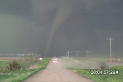
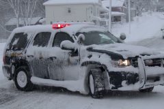
video of some Hail near Alliance, NE on 5/16 then the tornadoes near McCook and Farnum on 5/17.
Shot Description
1). Description slug.
2). Alliance, NE hail on 5/16. Short clip.
3). Blank space.
4). Setup commentary near Grant, NE.
5). Supercell NW of Grant.
6). Shots of tornadoes SW of Farnam, NE and northeastward.
7). Rain wrapped tornado NE of Farnam.
8). Storm lining out near I-80.
SID: Christopher Collura
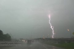
Severe storms rumble over Shreveport LA at the beginning of a severe storm and potential tornado outbreak for the Texas and Louisiana. Footage of close lightning bolts, low menacing clouds, heavy blinding rain.
All footage shot in Shreveport LA during morning and afternoon on April 13, 2019 by Meteorologist Juston Drake and Simon Brewer
1-4. various shots of close lightning bolts from severe storms over Shreveport LA
5. dark menacing cloud base of severe thunderstorm moving over Shreveport LA
6. pushed-in shot of dark cloud base moving over Shreveport LA
7 and 8. shots of traffic in very heavy rain and low visibility in severe thunderstorm in Shreveport LA
9-12. various shots of heavy rain during severe thunderstorms in Shreveport LA
SID: Simon Brewer Juston Drake
Thunder Snow, Lightning, Hail, Sleet, Blizzard Freezing Rain and some strange dust or pollen covering the snow and tinting it brownish.
Today in Saint Cloud, MN all you had to do was wait about a half hour and the weather would change from Blizzard conditions to Thunder Snow and Hail and Sleet to calm and then back to Blizzard conditions.
Footage shows lots of crashes, snow, lightning flashes, hail sleet with a wide variety of footage.
Shot Description
Clip 1 Driving on Interstate 94 in hail and sleet with blowing snow and poor visibility and VO talking about it.
Clip 2 Blizzard Warning on a road sign along Interstate 94.
Clip 3 Flash of lightning from the thunderstorm AKA Thunder Snow at time code 30;06
Clip 4 Dash camera of the lightning flashes from the Thunder Snow at time code 41;19
Clip 5 Driving and talking about the different sky scenes as it is brighter by the blizzard conditions but darker by the thunderstorm.
Clip 6 – 7 Roll over accident recovery on Highway 10.
Clip 8 Semi Truck jackknifed and facing the wrong way on the exit ramp.
Clip 9 State Trooper blocking traffic on Interstate 94.
Clip 10 Semi Truck jackknifed and facing the wrong way on Interstate 94.
Clip 11 – 16 Blowing snow in blizzard conditions before the thunder snow.
Clip 17 Hail and sleet from roof camera.
Clip 18 Driving in hail and sleet.
Clip 19 – 22 Snow plows.
Clip 23 – 24 Wind blew over a parking lot street light. Showing aftermath of it smashed on the ground.
Clip 25 – 26 Funky looking snow with a brown tint to it from dust or pollen.
SID: Doug Kiesling
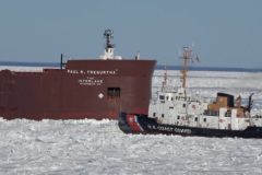
Ice Breaking Operations involving the United States Coast Guard and vessels from the Great Lakes Merchant Fleet on Northern Lake Michigan in the Straits of Mackinac.
All freighters in the area were beset or stuck for at least 24 hours until ice breaking operations could get underway.
Video ends with footage of the ship underway and transiting under the Mackinac Bridge and sailing by Mackinac Island, MI.
Shot Description
1) Cutter Katmai Bay breaking ice ahead of Paul R Tregurtha (largest ship on Great Lakes).
2) Katmai Bay bubbler system assisting it through ice.
3) Katmai Bay approaching PRT to assist freeing it from ice pack.
4) Same but wider angle.
5) Same but tighter shot.
6) Katmai Bay bubbler system assisting it through ice.
7) PRT plowing through ice.
8) USCG Katmai Bay passing our bow in heavy ice.
9) Zoom in of Katmai Bay bubbler system assisting it through ice.
10) Katmai Bay leading into the track.
11) Bow plowing throough ice field.
12) Looking back toward stern and then panning ice field.
13) Looking over bow toward path through ice field.
14-18) Various Clips sailing under the Mackinac Bridge in ice.
19) Mackinac Island views
SID: Eric Treece
A tow truck and a number of cars struggle up West Fillmore St. and other roads after snowfall causes slick roads February 22, 2019 in Colorado Springs, Colorado.
Shot Description
0:00 – A tow truck and another vehicle spin their tires traveling up West Fillmore St.
0:56 – Multiple cars struggle at the same time to travel up the street.
1:10 – Closeup shots of same cars struggling up the hill.
1:30 – Wide shot of intersection.
1:42 – Snow plow plowing the intersection.
1:51 – Closeup of snowplow plowing road.
2:02 – Car with hazard lights on up the hill with road closed signs at the intersection.
2:10 – Closeup of car with hazard lights up the closed road.
2:17 – Woman clearing snowy windows.
2:37 – Snowplow clearing road.
3:00 – Man walking through parking lot in snow.
3:08 – Midshot of parking lot in snow.
3:14 – Closeup of American flag in blowing snow.
3:21 – Car covered in snow.
3:32 – Car covered in snow closeup.
3:42 – Cars stuck on hill.
4:24 – Driving shot of cars on highways.
4:49 – Cars driving down I-25.
5:06 – Cars stuck on snowy hill.
SID: Trevor Cokley
To help support our freelancers, buy them coffee. https://www.buymeacoffee.com/stormchasing/
To License This Footage For Broadcast, Contact Video @ StormChasingVideo.com
Our Team Merch Store – https://stormchasingvideo.creator-spring.com
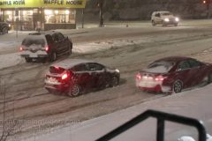
Another powerful winter storm hit central Minnesota and just in the Saint Cloud, MN metro area where dozens of wrecks were reported just around the noon hour as another half foot of snow blanketed the area.
Video has lots of wrecks, cars, trucks and semi along with snow plows and people just stuck in the ditches.
Shot Description
Scene One, 00:00 to 1:32 Several crashes and vehicles in the ditch on Highway 23 on the northeast side of Saint Cloud metro area.
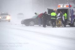
Scene Two, 1:32 to 3:25 Near Saint Joe, MN, major crash involving a semi truck and other vehicles on interstate 94. Crash happened when the semi truck was reended by the pickup truck. Soon other vehicles crashed into the ditch while trying to avoid the crash scene.
Scene Three, 3:25 to 4:16 Another crash and secondary crash scene on Interstate 94 near the county line north of Clearwater, MN
Scene Four, 4:16 to 5:53 Various cars, trucks, semi trucks stuck in the ditch along Interstate 94.
Scene Five, 5:53 to 7:03 Snow Plows around the Saint Cloud, MN metro area.
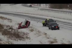
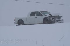
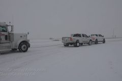
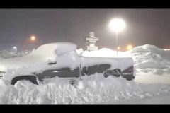
A large winter storm hammered portions of central Kansas dumping nearly a foot of snow in some areas across the region. The snow came down at rates that approached 2-inches an hour leading to extremely hazardous travel along K-96 between Wichita and Hutchinson. During the start of this storm, Wichita was not seeing snow while less than 20 miles northwest, extremely heavy snows were accumulating causing numerous accidents.
Video package includes footage from several wrecks in and around the city of Hutchinson, which is 45 minutes northwest of Wichita in Reno County. Includes a semi stuck in the snow that TWO pickup trucks pulled out together, a couple of spin outs where people were trying to push cars free, and a school bus that slid off the highway in northeast Hutchinson.
Shot Description
Scene 1: Long shot of two pickup trucks that tied themselves together pulling a semi truck free of the snow on an exit ramp in east Hutchinson.
Scene 2: Shot of semi truck before it was pulled free with a police SUV sitting behind it.
Scene 3: Sheriff’s SUV pulling into the exit ramp to close it off while the trucks pulled the semi free.
Scene 4: Tighter shot of semi stuck in snow with police SUV in foreground.
Scene 5: Shot of stuck semi and one of the pickup trucks.
Scene 6: Wide shot of semi scene.
Scene 7: The two drivers of the pickup trucks tying the straps together between their two trucks.
Scene 8: Shot of another spinout on K-96 with local police on scene as very intense snow falls.
Scene 9: Man attempting to push a red car out of the snow.
Scene 10: Shot of police officer and man trying to push red car free.
Scene 11: Wide shot of school bus that slid off into the snow off K-61 in northeast Hutchinson.
Scene 12: Tighter shot of school bus.
Scene 13: Side/behind shot of school us stuck in snow.
Scene 14: Shot of school bus stuck in snow.
Scene 15: Shot of school bus and tow truck.
Scene 16: Woman standing next to an SUV that is stuck in the snow.
Scene 17: Two people attempting to push SUV free of snow.
Scene 18: Tight shot of two men trying to push SUV out of the snow
Scene 19: Wide shot of SUV stuck in snow with passing traffic on K-96 south of Hutchinson.
Scene 20: Two men pushing a car down the road.
Scene 21: Van stuck in snow on the side of K-96 from behind.
Scene 22: Shot from the front of stuck van on K-96.
Scene 23: POV driving shot passing red car.
Scene 24-27: Various shots of snow plows in the snow.
Scene 28-29: Shots of traffic driving in very heavy snow.
SID: Tornadoes Kick Media
Winter storm brings very heavy snow to Northwestern Wisconsin this morning and afternoon. This video package will show the very heavy snow along with some of Rice Lake city crews out plowing the snow. The video was shot in and around the city of Rice Lake Wisconsin.
Shot Description
Clip 1. A truck fishing tailing as it was going to fast for the corner.
Clip 2-3. City of Rice Lake plows trying to keep up with the heavy snow. One vehicle following to close.
Clip 4-5. City plows working the same intersection hard to keep it safe.
Clip 6. A crew working on main street bridge in the heavy snow.
Clip 7. Someone walking in the heavy snow that is falling.
Clip 8-9. Traffic on snow covered roads with heavy snow falling.
Clip 10-13. Heavy snow falling.
Clip 14. Another person out walking in the heavy snow.
Clip 15. Snow covered car.
Clip 16-17. I had to clear the snow from my vehicle before heading out to shooting this video package.
Clip 18. Wooly the Mammoth getting covered in snow with heavy snow falling.
SID: Dirk Miller
Video from earlier today of untreated or summer blend diesel fuel freezing pretty much solid.
Time-Lapse Of non treated summer blend diesel fuel that is meant for use only in warmer climates and it freezes up into a wax like substance within two hours at -10F or -23C temperatures.
The fuel was stored at 74F (23C) just prior to this experiment to show what happens inside the fuel system of the vehicles with untreated diesel fuel if they drive from warmer weather and into the extreme arctic sub zero polar vortex conditions that have impacted a large portion of Canada and the United States this week.
Experiment to show why so much of the commercial traffic has been delayed due to the cold weather.
Shot Description
One long clip from a two hour long video that is edited into three parts that starts out in real time showing the diesel fuel is liquid and free flowing.
Then a time-lapse starts at about 20 seconds after the timer starts or at 37 seconds into the video and continues to about one minute and fifty five seconds into the video where you see the diesel fuel thicken up and gel up.
Then the last part of the video is in real time that shows the diesel fuel is pretty much solid and what it would look like in a fuel tank or fuel system such as a vehicles fuel filter.
Due to the intense lake effect snow, tractor trailers were routed off Interstate 81, and on to the side roads in Adams NY, and they quickly became stranded on the icy roads, as the town was buried under more than 2 feet of snow.
Shot Description
SHOT 1: Police struggle against white-out conditions while directing traffic in Adams, NY.
SHOT 2: State Troopers discuss how to free a bunch of stranded tractor trailers in Adams, NY.
SHOT 3: A plow passes by as police direct traffic in an intersection.
SHOT 4: Panning shot of a line of stranded tractor trailers in Adams, NY.
SHOT 5: A man uses a snow blower to clear more than 2 feet of snow.
SHOT 6: A man clears off nearly 2 feet of snow from his truck.
SHOT 7 & 8: Shot of cars buried in deep snow.
SHOT 9, 10, 11, 12: People struggling to shovel deep snow in heavy snow & wind.
SHOT 13: A large snow plow passes by.
SHOT 14: True white-out conditions in a residential area of Adams, NY.
SHOT 15: People shoveling have nowhere to put the snow because it is too high!
SHOT 16: Shot of deep snow accumulation on a house.
SID: Dave Lewison
A streamer of very heavy lake effect snow dumped several feet of snow on the eastern shores of Lake Ontario. Intense snow and frequent white-out conditions affected the I-81 corridor, near the town of Mannsville NY, causing vehicles to become stuck during the blinding snow.
Shot Description
SHOT 1: Shot of a person walking their dog as a snow plow comes up behind them
SHOT 2 & 3: Passing shot of a vehicle stuck in a ditch with police helping on I-81.
SHOT 4: Passing shot of an 18-wheeler stuck on the side of the road in blinding snow.
SHOT 5: A driver standing beside his stranded vehicle on the side of the road in heavy snow.
SHOT 6: A person digging out from a 5-ft snow bank.
SHOT 7: A person trying to shovel the sidewalk in heavy snow.
SHOT 8: A person using a snowblower to clear off a sidewalk.
SHOT 9, 10, 11: Driving on I-81 during white-out conditions.
SHOT 12: Huge icicles hang on a house in Mannsville, NY.
SHOT 13: Passing shot of heavy snow accumulations in Mannsville, NY.
SHOT 14: An old building on the corner during heavy snow in downtown Mannsville, NY.
SHOT 15: Traffic moving slowly past during heavy snow.
SID: Dave Lewison
To help support our freelancers, buy them coffee. https://www.buymeacoffee.com/stormchasing/
To License This Footage For Broadcast, Contact Video @ StormChasingVideo.com
Our Team Merch Store – https://stormchasingvideo.creator-spring.com
Very heavy lake effect snow and blankets Jefferson County, NY with feet of snow and frigid temperatures.
Shot Description
Shot 1: A nervous motorist talks with a snow plow operator at the entrance ramp to I-81 near Adams, NY as very heavy lake effect snow falls.
Shot 2: New York State Troopers help push a stuck motorist out of deep snow.
Shots 3-6: Near white out conditions in Adams, NY as very heavy lake effect snow falls. Vehicles navigating low visibility conditions.
Shot 7: A snow plow drives down the middle of the street in Adams, NY as the lake effect snow briefly lighten up in intensity.
Shot 8: A NY State Trooper vehicle navigates his way back into the driveway of their headquarters in Adams, NY
Shot 9: Vehicles navigate near whiteout conditions near Adams, NY.
Shot 10: A man snow plows a fast food restaurants parking lot as the snow briefly lightens up in intensity.
Shots 11-12: A person shovels multiple feet of snow on Main Street in Adams, NY.
Shot 13: A tractors hauls snow out of a parking lot in Adams, NY
Shots 14-15: Motorists clear snow off of their vehicles in Adams, NY.
SID: Scott McPartland
Blizzard slams Williamsville NY with nearly 2 feet of heavy lake effect snow, blowing snow from very high winds, low visibility whiteout conditions, very dangerous travel conditions on road and by foot, and dangerously low temperatures and wind chills.
Also amazing timelapse of intense classic lake effect snow band feeding off Lake Erie over Williamsville NY and Buffalo NY!
All footage shot during evening darkness and daylight on January 30, 2019 in/near Williamsville NY by Meteorologist Simon Brewer
Shot Description
1. car stranded in ditch after sliding off highway with police assistance
2. police assisting stranded motorist with traffic in low visibility blizzard conditions
3-5. various shots of traffic in low visibility blizzard conditions
6-10. various shots of vehicles buried under deep snow with blizzard conditions
11-17. various shots of blizzard conditions in Williamsville NY: low visibility, blowing and heavy falling snow, high winds
18 & 19. large American Flag whipped by strong winds in Williamsville NY
20 & 21. people walking in blizzard conditions in Williamsville NY
22. driving shot of homes buried in deep snow in Williamsville NY
23-25. various shots of homes buried under nearly 2 feet of snow in Williamsville NY
26. sidewalk canyon surrounded by nearly 2 feet of deep snow
27. POV driving shot of snow plow clearing highway in Williamsville NY
28. POV driving shot of whiteout on highway in Williamsville
29 and 28. shots of classic lake effect snow band feeding off Lake Erie causing blizzard over Williamsville and Buffalo NY
30. Incredible time lapse of classic intense lake effect snow band with sun overhead feeding off Lake Erie causing blizzard over Williamsville and Buffalo NY
SID: Simon Brewer
Car and Truck collide yards in front of camera during whiteout conditions! Blizzard conditions in Buffalo NY from extremely intense lake effect snow band! Record cold arctic air moving over a much warmer Lake Erie is feeding most intense lake effect snow band in years over Buffalo. Dangerous blizzard-whiteout conditions: accidents, vehicles in ditches, extreme cold, and high winds. Also amazing Time lapse of lake effect snow band feeding over Buffalo during early morning hours!
Video ends with an amazing shot of the lake effect snow coming in off the lake from the side of the band under blue sky.
All footage shot in/near Buffalo NY during morning daylight hours on January 30, 2019 by Meteorologist Simon Brewer
Shot Description
1 & 2. Incredible timelapse of lake effect snow band feeding off Lake Erie and dumping high amounts of snow on Buffalo NY
3. Vehicles pass, then complete whiteout, and loud “CRASH” on camera (at about 30 secs into clip) then visibility gets slightly better and a truck and car are smashed into each other only yards in front of camera
4-12. various shots of accident scene: police arrive, ambulance arrives, driver with neck injury loaded into ambulance, police putting out road flares, with periodic whiteout conditions
13-15. police stop to assist car stranded in deep snow with heavy snow falling and blowing, very low visibility
16 & 17. shots of snowplows attempting to clear snow in Buffalo NY
18 & 19. traffic jam from stranded vehicle with police assistance on I-90 in Buffalo NY
20. high winds and blowing and falling snow with bending grass in Buffalo NY
21. “1 degree F” temperature reading during blizzard conditions in Buffalo NY
22. As the sun comes out, just to the edge of the LES or Lake Effect Snow band you can see a perfect text book example of the snow band coming off the lake.
SID: Simon Brewer
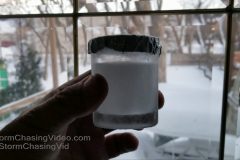
Vodka freezing with commentary and time-lapse plus tossing boiling water into cold air (-25 F).
Shot Description
1). 5 second title slug.
2). Commentary with Vodka showing 40%
3). Filling up glass and placing it outside.
4). Time lapse of it freezing in just 1 hour!
5). Frozen Vodka in glass.
6). Slush as it slowly defrosts (like glycol since it’s and alcohol).
7). Blank space (1 second).
8). Boiling water in pot with commentary.
9). Throwing it outside as FPV.
10). Second pot wide angle.
SID: Christopher Collura