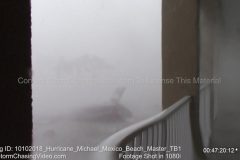
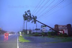
Hurricane Michael, Mexico Beach, FL 10/10/2018, Extreme Hurricane Eye Wall With Peak Winds And Storm Surge Footage Catalog
Master full length archive footage catalog from the most intense part of Hurricane Michael making landfall in Mexico Beach, FL on the far west side of the city at 41st street and highway 98.
Footage shows the start of the hurricane force winds making landfall and the most extreme part of the eye wall winds and storm surge destroying the town.
Video of vehicles, structures and all types of debris floating past the
camera.
Footage is mixed between 4KUHD and 1080i cameras that documented the storm worst of Hurricane Michael.
Catalog ID: 10102018_Hurricane_Michael_Mexico_Beach_Master_TB1
All footage © 10/10/2018 Tony Brite – All footage in this video was shot exclusively by Tony Brite and is being represented by StormChasingVideo.com LLC for licensing.
Contact http://www.StormChasingVideo.com To License This Material.
SID:Tony Brite
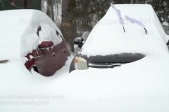
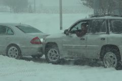
18 inches of deep snow buries Glens Falls NY! Major Winter storm hammers Upstate New York with WHITEOUT conditions, a foot and a half of snow and frigid temperatures. Dangerous icy and snow-covered roads caused numerous accidents.
All footage shot in/near Glens Falls NY during morning daylight and early predawn darkness on January 20, 2019 by Meteorologist Simon Brewer
Shot Description
1-3. cars buried under 18 inches of deep snow with creative sock coverings for wiper blades in Glens Falls NY
4. mailbox nearly buried under very deep snow in Glens Falls NY
5-7. man tries to clear over a foot and half of deep snow from driveway with snowblower in Glens Falls NY
8-10. various shots of multiple vehicles buried and trapped under deep snow in Glens Falls NY
11 & 12. driving passing shots of buried neighborhoods (homes and vehicles) in Glens Falls NY
13. pushed-in shot of traffic on icy and snow-covered I-87 with heavy snow falling and low visibility in Glens Falls NY
14 & 15. truck stranded in deep snow in ditch on I-87 with police assistance after sliding off ice-covered roadway in Glens Falls NY
16. pedestrian walking in street because nearly 2 feet of snow buried sidewalk in Glens Falls NY
17. WHITEOUT CONDITIONS with traffic on snow-covered I-87 in Glens Falls NY
18-20. various shots of snow plows clearing deep snow in Glens Falls NY
21 & 22. POV driving shots of traffic on snow-covered I-87 with heavy snow falling and low visibility in Glens Falls NY
23. predawn electronic highway sign warning of winter storm near Glens Falls NY
24-28. predawn snowplows attempt to clear snow and ice from I-87 near Glens Falls NY
SID: Simon Brewer
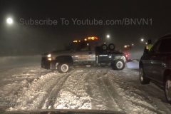
Winter Storm Eboni is impacting the Fargo, ND area, crippling traffic and creating headaches for those who live here. This video includes people getting pulled out of the ditch and how bad conditions are this evening when the Blizzard was at it’s peak intensity.
Shot Description
Shot 1: Multiple vehicles stuck in the road.
Shot 2: Vehicle getting pulled out of the ditch by a tow truck.
Shot 3: Second Vehicle getting pulled out of the ditch.
Shot 4: Tow truck unhooking from a vehicle.
Shot 5: People walking with shovels after helping shovel out a car.
Shot 6: Snowplows in the City of Fargo.
Shot 7: Poor visibility in the City of Fargo
Shot 8: Person stuck in a snowbank with someone trying to push them out.
Shot 9: Person trying to get out of a snowbank.
Shot 10: Near zero visibility on Interstate 29 through Fargo.
Shot 11: Plow passing on Interstate 94
SID: Eric Whitehill
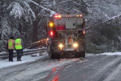
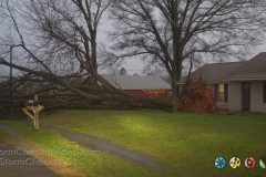
Footage of tree snapping and falling on another tree blocking I-85 near Richmond VA from heavy wet snow and freezing rain. Dangerous situation in Richmond VA area with widespread trees and tree branches snapping under combined weight of heavy wet snow and freezing rain. Vehicle accidents and traffic jams across entire Richmond Metro area.
All footage shot during Evening darkness and daylight in/near Richmond VA on December 9, 2018 by Meteorologist Simon Brewer
Shot Description
1 & 2. shots of large tree blocking Interstate 85 (I-85) snapped from heavy weight of wet snow and freezing rain near Richmond VA.
3 & 4. shots of tree snapping and falling on tree almost hitting people trying to clear tree blocking I-85
5-8. various shots of another large tree blocking I-85 causing massive traffic jam near Richmond VA and snow plow trying to smash and move the tree
9. POV driving shot passing large tree on I-85 near Richmond VA
10 & 11. POV driving shots of large trees bending over I-85 under combined weight of heavy wet snow and freezing rain in Richmond VA
12-22. various shots of vehicles wrecked and/or stranded in deep snow-covered I-95 in Richmond VA
23. pushed-in shot of people dragging luggage through snow to get to hotel after major traffic jams from terrible winter storm in Richmond VA
24-26. various shots of snow plows trying to clear highways around Richmond VA
SID: Simon Brewer
Tornado on the ground in Beardstown, IL Video while driving through the town of Beardstown, IL while the tornado touches down.
Footage by Meteorologist Simon Brewer
Shot Description
Clip 1 Tornado touching down nearby the camera position then goes back in the air.
Clip 2 Tracking the tornado through the town.
SID: Simon Brewer
Video of the blizzard from Kansas City Mo. Shots of KCI airport, slideoffs and shoppers near a Walmart.
Shot Description
First set of clips is near the Kansas Speedway advising of blizzard conditions. Next set of shops are near the KCI airport with many canceled flights. Third set of shots shows travelers trying to enter the airport in blizzard conditions. Fourth set of shots shows travelers trying to reschedule flights at the Southwest counter. Fifth set is the near whiteout conditions on the runways/taxiways. Sixth set of shots are of slideoffs with no injuries along I29 that is shutdown just north of here. Seventh set is shoppers trying to enter the local Walmart. Eighth set is of Walmart workers having difficulty pushing carts back into the store.
SID: Steve Polley
Much more snow than expected falls on the NYC Metro from the first significant winter storm of the season.
Shot Description
Shots 1-5: People out and about in heavy snow on Main Street in Flushing, NY (Queens County)
Shot 6: Traffic on the Long Island Expressway is at a stand still as heavy snow falls.
Shot 7: People line up at a bus stop in Flushing as heavy snow continues to fall during the evening rush hour.
Shot 8: People walk by and enter the subway station in Rego Park, NY.
Shots 9-11: People out and about in heavy snow in Flushing, NY after sundown.
Shot 12: A bicycle covered in snow is chained to a fire hydrant.
Shots 13-15: Snow continues to fall after sundown on a residential street in Queens, NY.
Shots 16-17: Car dash POV of heavy traffic on the Long Island Expressway in Queens, NY as snow continues to fall.
SID: Scott McPartland
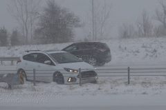
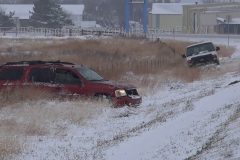
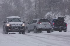
Heavy snows across southwest Kansas overnight lead to extremely icy conditions in the snow’s wake. While over 5 inches of snow fell, the main problem was the freezing surfaces on area highways. US-50 between Garden City and Cimarron was completely covered in ice for the entire 30 miles between the towns. This lead to numerous spin outs and a near triple drive time. This drive, which normally takes 30 minutes, took an hour and a half.
Shot Description
GARDEN CITY
Scene 1: Snowplow driving by an SUV that spun off the highway.
Scene 2-3: SUV trying and failing to get on the road, spinning tires and sliding sideways through the ditch.
Scene 4-5: A pickup truck on the other side of the highway spinning tires in the ditch. Includes tight shot of tires spinning.
Scene 6: Panning shot of the two pre-sunrise spin offs.
GRAY COUNTY WEST OF CIMARRON
Scene 7: Wide shot of two vehicles that spun off the highway near Cimarron with another vehicle with flashers on parked on the side of the road.
Scene 8: Tight shot of the two spin outs.
Scene 9: A pickup with front end damage with flashers on sits stuck on the side of the highway as vehicles drive by.
Scene 10-12: White car that slid off the highway pointing nose down into the ditch.
Scene 13-14: Red car the crashed into a barbed-wire fence off US-50.
Scene 15: Black pickup struggling to maintain control on the icy US-50 drive.
Scene 16: POV driving shot of the coating of ice along US-50.
Scene 17-19: Various shots of traffic slowly navigating the icy US-50.
SID: Tornadoes Kick Media
Drivers tread carefully on snow covered roads as residents of Manitou Springs dig out after heavy snowfall blankets the front range in El Paso County, Colorado on November 11, 2018.
Shot Description
1. 0:00 Close: Cars slide on steep road near Manitou Springs.
2. 1:41 Wide and Medium: Snow plows snow and cars follow through intersection.
3. 1:59 Medium: Cars travel through intersection with mountain in background
4. 2:06 Close: Serpentine Drive Sign in heavy Snow.
5. 2:12 Medium: Cars travel downhill on snow covered highway.
6. 2:21 Medium: Scenic shots of mountains and hills near Manitou Springs
7. 2:35 Medium: Cars travel through Manitou Springs
8. 2:41 Residents Clear Snow and cars
9. 3:00 Wide: Snow Covered Maniou Springs Shops
10. 3:05 Close & Medium: Veterans Day Signs
11. 3:15 Medium: Highway Traffic in Heavy Snow
SID: Trevor Cokley
Intense high wind gusts over 100 mph slam Kirkland NC as eyewall of Hurricane Florence moves inland. Shots of damage and calm eye of Florence.
All footage shot in/near Kirkland and Seagate NC during morning of September 14, 2018 by Meteorologists Juston Drake and Simon Brewer
Shot Description
1-9. various shots of over 100 mph wind gusts inside intense eyewall of Florence over Kirkland NC
10 & 11. large trees felled in Kirkland NC from high winds in eyewall
12. shot of large trees swaying in high winds before eye moves over Kirkland NC
13. large utility pole snapped with dangling lines in Kirkland
14. large tree felled and leaning on utility lines in Kirkland
15. large utility pole snapped and held by lines in Kirkland
16. shot of multiple trees down blocking neighborhood in Seagate NC during calm eye
17. large traffic signal light on road following intense eyewall of Florence in Seagate NC
18. panning (up) shot of large tree snapped high (top of tree on ground) in Seagate
19 & 20. shots of traffic lights dangling only a few feet above highway in Seagate
21. large tree felled next to business in Seagat
22. shot of bright clouds in calm “eye” of Hurricane Florence over Seagate
23 & 24. large tree down in front of house near Seagate NC
SID: Simon Brewer Juston Drake
Red tide continues to kill bull sharks and many other fish in Sarasota Bay at the Sarasota Manatee County border in SW Florida. Also, includes in over and underwater shots showing red tide infested bay water.
Shot Description
1-6) Six varied shots of dead bull sharks floating at marina on Sarasota Bay.
7) Low angle of hundreds of dead mullet floating near docks.
8) Over/under water shot showing red tide algae in water and dead mullet at docks.
9) Low angle traveling shot over dead mullet spanning over water at docks.
10) Over/under water shot near dead bull shark showing nasty red tide infested water.
11) closer shot of dead mullet fish.
12) Tilt up of dead fish revealing boats at docks on bay waters.
13) Medium Pan over dead fish.
14) Lock shot of scene of dead fish at docks.
15) Close pan over dead fish.
SID: Subsurface Media
New footage in of the tornado hitting Marshalltown, Iowa and the storm damage after the tornado hit the town.
SID T Cook Media
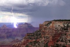
Lightning strike in the Grand Canyon captured at 480FPS at Cape Royal of the North Rim.
Shot Description
Shot 1: Lightning strike within the Grand Canyon. Video captured at 480 FPS.
Shot 2: Slowed to 1/4 speed of the same lightning bolt.
Shot 3: More lightning captured from the north rim. This lightning was located just on top of the south rim.
Shot 4: Wide shot of more lightning on the south rim.
SID: Bryan Snider
Time-lapse sequence of Haboob / Dust Storm coming into Phoenix, Arizona
Shot Description
Shot 1: Wide time lapse (20mm Full-frame) of a dust storm beginning to approach the city.
You can see the dust storm start to come over South Mountain. Eventually, the dust starts to cover the mountains
Shot 2: Ultra wide time lapse (14mm Full-Frame) of the wall of dust moving further into the city reducing visibility significantly.
During this shot, you’ll notice planes continuing to land and take off.
SID: Bryan Snider
A GoFundMe page has been setup for one of the victims who lost her legs in this tragic event. Click here to donate. https://www.gofundme.com/stefanie-schaffer-and-family
For members of the media, this video is being licensed by StormChasingVideo.com contact us to license this footage.
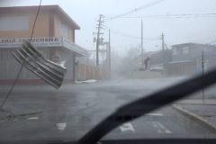
A female American tourist is dead and several others are injured after a boating accident of the coast of the town of Barraterre, off the island of Exuma, Bahamas.
According to reports, shortly after 9am, a 40’ chartered tour boat was traveling in waters just off Barraterre, with 10 American tourists and two Bahamians on board, when an engine exploded causing the boat to catch fire.
Ten people on board were injured and transported to the mini hospital in George Town. One female succumbed to her injuries. Several others are being airlifted for further medical treatment to Nassau with possible further airlift to Miami, FL.
Shot Description
Long shot from a boat that came to the rescue of burning boat as people were pulling survivors off the burning boat.
Chris Töpperwien
http://www.instagram.com/currywurstmann_official
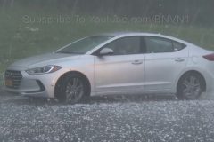
A rare supercell thunderstorm in NY State drops hail up to baseball size near Saugerties, NY damaging many vehicles along the Taconic State Parkway.
Shot Description
Shots 1-7: Hail between golf ball size and baseball size falls on unsuspecting motorists along the Taconic State Parkway near Saugerties, NY.
Shots 8-11: Motorists inspect damage to their vehicles in the wake of the hailstorm.
SID: Scott McPartland
Several Tornadoes docuented near Falkville, Moulton and Russellville AL as storng torandic supercell charges across the state causing damage.
All footage shot in/near Falkville, Moulton and Russellville AL during evening daylight on March 19, 2018 by Meteorologists Juston Drake and Simon Brewer
Shot Description
1. tornadic supercell with lightning flash over Russellville AL
2-6. various shots of rain-wrapped tornado over Russellville AL
7. shot of tornadic supercell approaching Russellville AL
8 & 9. shots of funnel clouds near Moulton AL
10-12. shots of high winds hammering Falkville Al as tornado passes by causing damage
13-19. various shots of heavy tree damage in/near Falkville AL from possible tornado
20. flag pole bent and flag in tatters from possible tornado in Falkville AL
21. shot of tree blocking road knocked down near Falkville AL by possible tornado
22-32. various shots of close dramatic regular and slow motion lightning strikes near Russellville, Moulton and Falkville, Alabama from tornadic supercell
SID: Simon Brewer Juston Drake
Limited Edition StormChasingVideo.com Merch http://www.stormchasingvideo.com/scv-merch-store/
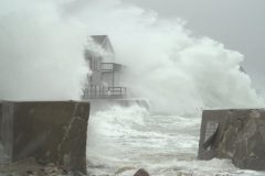
Massive destructive waves and storm surge damage homes in Scituate MA causing some neighborhoods to become small islands surrounded by ocean. Shots of damaged neighborhoods, flooded homes, massive destructive waves tossing small boulders and rocks.
All footage shot during afternoon daylight on March 2, 2018 in Scituate MA by meteorologist Simon Brewer
Shot Description
1-11. various shots of massive destructive waves crashing into homes and seawall in Scituate MA tossing small boulders and rocks into home and roads
12-15. various shots of damage to neighborhood homes and roads in Scituate MA from storm surge and massive waves
16-24. various shots of flooded homes and roads as storm surge pushes into Scituate MA creating small island neighborhoods cutoff from the mainland
25. shot of pedestrian surveying massive waves in Scituate MA
SID: Simon Brewer
This is a test video from our studios where we did a time lapse of a plant that had not been watered in several weeks being watered and coming back to life over a 6 hour time frame.
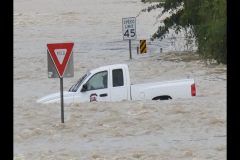
Welcome to part three in our compilation series called “Ridiculous Car Crashes” where we highlight people driving poorly in flooding and in winter conditions.
To see part one of this series, check out https://youtu.be/i59v0p-gAtk
To see part two of this series, check out https://youtu.be/XavVVS1IYyY
All material in this video is part of our stock footage catalogs.
Contact StormChasingVideo.com to license the footage in this video.
SID: Compilation
To help support our freelancers, buy them coffee. https://www.buymeacoffee.com/stormchasing/
To License This Footage For Broadcast, Contact Video @ StormChasingVideo.com
Our Team Merch Store – https://stormchasingvideo.creator-spring.com
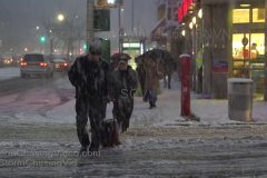
Footage of the Blizzard / Nor-Easter from the backside of the storm in Brewster, NY as the frequent wind gusts over 40mph created instant whiteout conditions in the heavy snow squalls. B-Roll of the miserable conditions and people struggling to cope with the weather.
Shot Description
SHOT 1: A person struggles to pull a shopping cart in whiteout blizzard conditions.
SHOT 2: Whiteout blizzard conditions in a parking lot makes cars disappear from view.
SHOT 3: A strong wind gust creates an instant whiteout with a loading dock in the background.
SHOT 4: Blizzard conditions rage with a local storefront in the background.
SHOT 5: A car struggles to pull out into an intersection on slippery roads.
SHOT 6: An SUV pushes a stuck car out of an intersection.
SHOT 7: Passing by a stuck car on the side of I-84.
SHOT 8: Passing by a struggling tractor trailer on I-84.
SHOT 9: Strong winds whip up a whiteout of snow past a parked car.
SHOT 10: Driving on I-84 as a sudden gust creates near zero visibility.
SHOT 11: A person struggles against the wind while walking.
SHOT 12: A front end loader plows snow up high in a parking lot.
SHOT 13-14: A person struggling while walking in blizzard conditions.
SHOT 15: A snow plow passes by and then disappears into the blizzard.
SHOT 16: People loading up a truck disappear from view in the heavy snow.
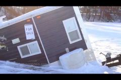
While temps may have been subzero for sometime now. There are spots on area lakes that still aren’t that safe do to the snow cover on the ice. This video package shows an Ice Castle that broke through the ice, along with the recovery from Poskin Lake.
Shot Description
Clips 1-4 Different shots of the an ice castle that broke through the ice.
Clip 5. Ice recovery crew getting setup to recover the ice castle.
Clip 6. Diver is cutting away the ice from the ice castle.
Clip 7. Crew is removing ice from the ice castle.
Clip 8- 9. Crew is lifting the ice castle.
Clip 10. The crew pulling the ice castle to safer ice.
Clip 11-12. People watching the ice castle recovery efforts.
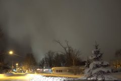
Intense lake effect snows continue into the evening hours creating treacherous travel conditions in Upstate NY.
Video starts out with the rare back lit look at the lake effect snow band moving in off the lake and dumping heavy snow.
Shot Description
Shot 1: Eerie clouds lit up by city lights signal intense lake effect snows moving into Sandy Creek, NY.
Shot 2: Heavy snow materializes out of no where in Sandy Creek, NY.
Shot 3: Heavy snow creates treacherous travel conditions on the I-81 in Oswego County, NY.
Shot 4: A man clears snow off of his vehicle at a gas station in Sandy Creek, NY.
Shot 5: A man snow blows his driveway in Oswego County, NY.
Shot 6: A snow plow passes behind a massive mound of snow in Oswego County, NY.
Shot 7: Telephoto shot of Main Street in Sandy Creek, NY with huge mounds of snow lining either side of the street.
Shot 8: A snow plow drives down Main Street after sundown as snow continues to fall.
Shot 9: Several feet of snow pile up on top of ice machines at a local grocery store in Sandy Creek, NY.
Shot 10: A lady voices her hatred of the snow as she drives by the cameraman.
Shots 11-13: Huge amounts of snow pile up on roofs of residential homes in Sandy Creek, NY.
Shot 14: A snow plow drives down a residential street in Oswego County, NY.
Shot 15: Car dash POV shot of heavy snow falling on the I-81 in Oswego County, NY.
Shots 16-17: People using snow blowers to clear snow from their driveways in Oswego County, NY.
Shot 18: Several feet of snow pile up around homes in Oswego County, NY.
Shot 19: Car tires spin, as a motorist attempts to get out of deep snow in Oswego County, NY.
Shots 20-21: People out and about cleaning up after several feet of snow fall in Oswego County, NY.
CAT 4/5 eyewall winds from Hurricane Maria rip apart Yabucoa, Puerto Rico as eye makes landfall. Roofs ripped off, debris flying, lightning in the intense eyewall, Meteorologists Juston Drake and Simon Brewer measure 926.6 mb minimum central pressure in eye of Maria.
All footage shot during early and late morning darkness and daylight on September 20, 2017 in Yabucoa, Puerto Rico by Meteorologists Juston Drake and Simon Brewer.
Shot Description
1-9. Various shots of extremely high CAT 5 winds in eyewall blowing debris and causing destruction in Yabucoa, Puerto Rico as Hurricane Maria makes landfall
10. shot of ROOF BLOWN OFF HOUSE in Yabucoa, Puerto Rico from high winds
11-14. various shots of extremely high CAT 5 winds in eyewall from landfalling Hurricane Maria causing destruction in Yabucoa, Puerto Rico
15. SHOT OF LIGHTNING in intense eyewall of landfalling CAT 5 Hurricane Maria in Yabucoa, Puerto Rico
16 & 17. shots of high CAT 5 eyewall winds from Hurricane Maria blowing debris in Yabucoa, Puerto Rico
18. shot of Barometer measuring 926.6 mb minimum central low pressure in eye of CAT 5 Hurricane Maria by Meteorologists Juston Drake and Simon Brewer
19 & 20. funnel clouds on edge of inner eyewall as backside of CAT 5 Hurricane Maria begins to pound downtown Yabucoa, Puerto Rico following passage of the calm eye
21-26. shots of blowing debris and destruction in downtown Yabucoa, Puerto Rico as backside eyewall of CAT 5 Hurricane Maria pounds city
27. pushed-in shot of ROOF ripped off building in downtown Yabucoa
28-33. shots of blowing debris and high winds ripping apart downtown Yabucoa
34. large window ripped from building from high eyewall winds in downtown Yabucoa, Puerto Rico
Stringer: Simon Brewer & Juston Drake
To help support our freelancers, buy them coffee. https://www.buymeacoffee.com/stormchasing/
To License This Footage For Broadcast, Contact Video @ StormChasingVideo.com
Our Team Merch Store – https://stormchasingvideo.creator-spring.com