Footage from Saint Thomas, US Virgin Island of the aftermath and recovery efforts.
B-Roll footage and interviews with local residents about the storm and the recovery efforts.
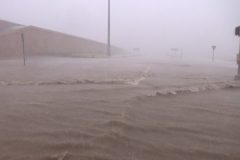
Nearly a foot of rain from Hurricane Irma caused extensive fresh-water flooding in the Lehigh Acres suburb of Ft. Myers FL. Shots of flooded vehicles, people wading in deep water, traffic driving through flood waters, and some wind damage to structures.
Shot Description
SHOT 1: A man tries to bail water out of his flooded vehicle.
SHOT 2: Telephoto shot of traffic driving down flooded roads in Ft Myers FL.
SHOT 3: A few people wading through knee-high water in the streets of Ft. Myers FL.
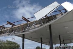
SHOT 4-5: A gas station awning destroyed by Irma’s intense winds.
SHOT 6: A flooded pickup truck in Ft. Myers FL.
SHOT 7: A man sits in his stalled-out vehicle among flood waters in Ft. Myers FL.
SHOT 8: A flooded business front on Lee Blvd in Ft. Myers FL.
SHOT 9: Two flooded vehicles in a parking lot on Lee Blvd in Ft. Myers FL.
SHOT 10: Flooded street signs and mailboxes along a street in Ft. Myers FL.
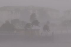
Hurricane Irma’s core rain bands approaching Punta Gorda FL. Various shots of intense winds, rain and blowing sea spray, along with some minor damage to buildings.
Shot Description
SHOT 1: Shot of winds beginning to tear the shingles off a building.
SHOT 2: Distant palms bending in the wind amidst blowing sea spray.
SHOT 3: Distant shot of intense winds and sea spray on the Punta Gorda causeway bridge.
SHOT 4: Shot of palm trees with blowing spray going across the sidewalk.
SHOT 5: Intense wind and rain bands blow past a couple of vehicles parked on the road.
SHOT 6: Shot from inside a parking garage stairwell as the wind blows in, creating an incredible sound.
SHOt 7: Some minor roof damage to a building in downtown Punta Gorda.
SHOT 8: A tree snapped in half by the strong winds.
SHOT 9: A restaurant sign blowing around in the strong winds.
SHOT 10-13: Various shots of strong winds and blowing palm trees on city streets of Punta Gorda.
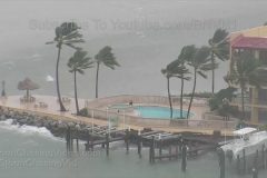
Hurricane Irma hitting Key West and Marathon. Multi-remote cameras catch four boats drifting out to sea in Irma and wind & storm surge hitting Key West and Marathon.
Shot Description
1) Wide shot of Irma pounding Mallory Square with a boat drifting offshore in distance.
2) Massive wave action in the Key West channel between Mallory Square and Sunset Key.
3,4,5) Three shots of boat drifting out to sea in storm.
6,7) Two shots of Irma pounding Marathon FL.
8,9) Two shots of two sailboats drifting out to sea in storm.
10) Wind and rain at Front and Duval street, Key West.
11,12) Surge pounding Southern Most Beach pier.
13) Timelapse at Mallory Square catching another boat drifting out to sea.
14) Night shot of storm hitting at Front and Duval street.
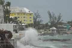
Huge swells crash over seawalls and wash onto roads as the beginnings of a massive storm surge rise in Key West FL with approach of Hurricane Irma. Shots pedestrians, high winds, some tree damage debris, and other various shots in Key West.
All footage shot during morning daylight in Key West FL on September 9, 2017 by Meteorologists Juston Drake and Simon Brewer
Shot Description
1. shot of winds blowing flags and trees at National Weather Service Office in Key West
3-5. pushed-in shots of agitated seas along Key West FL coast
6-7. shots of massive waves crashing against Key West seawall
8-18. shots of surge water washing onto highway in Key West FL
19. various shots of massive waves crashing over seawalls in Key West FL
20-21 . pushed-in shot of vehicle driving through flooded road with large waves crashing in background at the “Southern Most Point Buoy”
22. shots of high winds blowing palm trees in Key West FL
23. shot of vehicles driving around tree branch in roadway in Key West
24. shot of car driving in high winds
25. shot of a resident rooster keeping watch over Key West
26. shot of 2 men riding bikes in high winds with blowing debris in Key West
27. shot of “Key West Evacuation Sign”
28 & 29. shots of beginning of US Route 1 in Key West with rainy feeder band hitting area
Waterspouts south of Key West from outer edge storms from CAT 5 Hurricane Irma. Shots of evacuated and shuttered Florida Keys. Shots of final sunset over Key West before monster hurricane strikes. Shots of 1935 Labor Day Hurricane Memorial containing the remains of many victims of the most powerful hurricane to strike the United States on Islamorada with hurricane flags in the background.
All footage shot during evening daylight and darkness on September 8, 2017 over several Florida Keys including Islamorada, Marathon, and Key West by Meteorologists Juston Drake and Simon Brewer
Shot Description
1-5. various shots of waterspouts and parent thunderstorm from outer edges of Hurricane Irma south of Key West FL
6. POV driving shot of empty HWY 1 causeway looking west toward end of Florida Keys before landfall of Hurricane Irma
7-9. shots of vehicles parked along HWY 1 along edge of causeways to protect from coming storm surge over the Florida Keys
10. “Hurricane” sign at boarded shop in Marathon FL
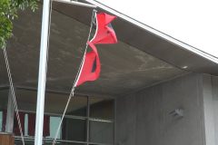
11. tattered Hurricane flags over Marathon FL
12. “Screw you Irma”, “We are Marathon strong” signs in Marathon FL over business
13. driving shot of boarded and shuttered homes and businesses in Key West FL
14. “Be Gentle Irma” painted on boarded restaurant in Key West FL
15 & 16. shots of boarded and shuttered shops on famous Duval Street in heart of Old Town Key West FL
17 & 18. storm and palm trees with final sunset before Hurricane Irma slams Key West FL
19-22. various shots of boarded Key West at night with several locals staying to ride out the storm on Duval Street
23-28. various shots of the 1935 Labor Day Hurricane Memorial, which is also a tomb for many of the storm’s victims on Islamorada FL. This was the strongest hurricane to ever hit the United States.
Video of the first impacts of Hurricane Irma and tropical storm force winds and large waves hitting the capital city of Nassau Bahamas
Shot Description
Clip 1 Waves crashing on the shoreline
Clip 2-3 Waves crashing over a dock
Clip 4 Waves and palm trees blowing
Clip 5 Long shot of the trees blowing with the dock in the distance
Clip 6 Palm trees blowing
Clip 7 Light house and waves
Clip 8 Wide long shot of the Atlantis Resort with pull back in the wind to the coast.
Clip 9 Waves at the beach pull back to show the whole area with the Atlantis Resort in the back ground.
Clip 10 Palm trees blowing in the wind.
Clip 11 Red Flag blowing in the wind
Clip 12 13 Waves and beach cabanas with pull back shot
Clip 14 Waves
Clip 15 Trees
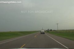
Video of hundreds of miles of traffic of people leaving hurricane Irma. Shots of lines of people waiting to fill gas tanks with fuel. Sound with a traveler leaving southern Florida.
Shot Description
shot 1 tight traffic evac
shot 2 tight cars in line
shot 3 boat on trailer
shot 4 sign
shot 5 wide of traffic
shot 6 tight traffic
shot 7 telephoto of cars in line
shot 8 family with dogs
shot 9 turnpike backup
shot 10 wide shot of traffic
shot 11 moving shot of traffic
shot 12 wide of gas station
shot 13 traffic lines
shot 14 girl at pump
shot 15 tight of pump
shot 16 follow handle to tank
shot 17 low angle pump
shot 18 wide cars
shot 19 lines
shot 20 intv Robert Randall Fort Meyers
SID: John Haxby
Residents and Businesses prepare for Hurricane Irma by boarding up. People wait in line for gas. Tourists take last minute photos at the Southern Most Point
Shot Description
Sloppy Joe’s with workers in BKGD.
CU of workers boarding up a Store on Duval Street.
CU of Saw cutting Plywood
Workers Boarding up a Bar on duval.
Owners boarding up a Gallery on duval.
Lone tourist rolling suitcase down Duval Street
tourists getting last minute shots of Southernmost Point before evacuating
House Boat in Key West being Boarded up
Long Traffic lines as people begin to leave
Long wait times as Gas station
Houses being Boarded up in Key West
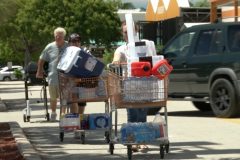
B-roll and SOTs of people stocking up at Home Depot in Key West before Irma arrives.
Shot Description
W/M/T of truck being loaded with Plywood.
Shopping Carts filled with Supplies
Truck being loaded with Huricane Shutters
SUV being loaded with Water
SOT with water guy
Cart filled with Supplies and being loaded into a van
SOT with Couple
Hot Dog Vendor
SOT with Hot Dog Vendor
Truck being Loaded with Plywood
SOT with Plywood Guy
SOT with guy who has Plywood in his car.
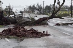
Damage, debris, storm surge and flooding aftermath in Rockport TX after Category 4 Hurricane Harvey pounded city and surrounding areas.
To help support our freelancers, buy them coffee. https://www.buymeacoffee.com/stormchasing/
To License This Footage For Broadcast, Contact Video @ StormChasingVideo.com
Our Team Merch Store – https://stormchasingvideo.creator-spring.com
All footage shot in/near Rockport TX during morning of August 26, 2017 by Meteorologists Juston Drake and Simon Brewer
Shot Description
1 & 2. shots of snapped palm tree from severe high winds in Rockport TX
3. shot of bent Rockport TX sign
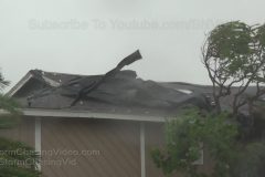
4-6. shots of the heavily damaged Americas Best Value Inn hotel in Rockport TX
7 & 8. shots of damage brick wall from grocery store in Rockport TX
9. pushed-in shot of damaged neighborhood and bent utility poles in Rockport TX
10 & 11. shots of car partially underwater and damaged neighborhood in Rockport TX
12-17. shots of destroyed buildings and homes and flooded neighborhoods in Rockport TX
18. shot of gas station roof on highway in Rockport TX
19. shot of huge trees and debris in road in Rockport TX
20. shot of camper thrown from nearby store in middle of intersection in Rockport TX
21. shot of flooded highway with vehicles driving through in Rockport TX
22. driving shot of vehicles driving through flooded roads in Rockport TX
23 & 24. shots of heavily damage and flooded mobile home/trailer/RV park near Rockport TX
25-27. shots of loose cattle around Highway 35 with police car near Rockport TX
SID: Simon Brewer & Juston Drake
#HurricaneHarvey
#Hurricane
#Harvey
Strong winds / waves … Leading edge of Hurricane Harvey’s core
Shot Description
1). View of pier and waves.
2). Palm tree blowing.
3). Waterfront home / roof damage.
4). Close shot of pier and waves.
5). Damaged boat in marina.
6). Hurricane conditions and palms.
7). Hurricane conditions and cars.
8). Sailboats leaning in marina.
9). Shot of restaurant and strong winds.
SID: Chris Collura
#HurricaneHarvey
#Hurricane
#Harvey
Morning lightning with strong feeder band hitting coastline, ship rocking from high winds and choppy water, flock of birds riding strong winds, sheet metal down from high winds, boarded businesses in advance of Hurricane Harvey, increasing winds blowing vegetation and flags.
All footage shot during afternoon and morning daylight in/near Ingleside, TX on August 25, 2017 by Meteorologists Juston Drake and Simon Brewer
Shot Description
1-3. lightning illuminates powerful feeder band over coastline as Hurricane Harvey rapidly intensifies in the early morning hours
4. sail boat rocks in high winds and choppy water as Hurricane Harvey approaches
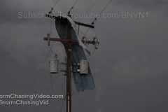
5 & 6. shots of sheet metal down from shop torn down by high winds as Hurricane Harvey approaches Ingleside, TX
7 & 8. driving shots of businesses near Ingleside TX boarded in advance of Hurricane Harvey
9 & 10. pushed-in shots of American Flag blown by high winds
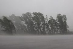
11-13. palm trees blown by increasing winds from Hurricane Harvey in Ingleside, TX
14. shot of rain and palm trees blowing against window in Hurricane Harvey
15-17. shots of flock of gulls riding increasingly high winds as Harvey approaches Ingleside, TX
18 & 19. shots of palms blowing in high winds in Ingleside TX as Harvey approaches
SID: Simon Brewer & Juston Drake
#HurricaneHarvey
#Hurricane
#Harvey
4K Time lapses of an isolated monsoon thunderstorms that produced a microburst and lots of lightning.
Shot Description
Wide angle time lapse of a maturing isolated monsoon thunderstorm. This storm eventually produces a very photogenic micro burst and several mini ones off to the sides.
Tight angle time lapse of the same maturing storm. Microburst captured up more closely in this shot.
Medium shot of a VERY isolated thunderstorm that produced several photogenic cloud-to-ground lightning strikes just after sunset.
B-Roll and Time Lapse Package of an Arizona haboob and it’s impact on the interstates and Phoenix Sky Harbor.
Shot Description
Shot 1: Wide shot of dust getting kicked up from a strong out flow boundary.
Shot 2: Gustnado and lots of dust moving closer to interstate 10.
Shot 3: Time Lapse of the wide shot showing the dust moving into the Arizona town of Casa Grande near I-10 and I-8.
Shot 4: Dust moving very fast and reducing visibilty on the desert right next to Interestate 10
Shot 5: Wide shot of more dust moving across the desert.
Shot 6: Tight shot of very thick dust moving over a desert plant.
Shot 7: Dust now organized into a Haboob moving over the mountains of Central Arizona
Shot 8: Medium shot of haboob even larger moving over mountains and the Saguaros of central Arizona.
Shot 9: Wide shot of haboob moving closer to I-8. This dust storm reduced visibility and made a significant impact on I-8.
Shot 10: Pano of haboob moving into Gila Bend, AZ
Shot 11: Wide shot of isolated thunderstorm on the west side of Phoenix Sky Harbor. This storm shut down the airport (Phoeinx Sky Harbor) briefly causing some delays at the airport.
Shot 12: Wide shot of airplanes lined up waiting for the airport to open back up.
Shot 13: Medium Shot. The airport reopens and planes begin to depart and arrive again at Phoenix Sky Habor.
Shot 14: Tight Shot: Plane taking off
Shot 15: Another plane takes off as dust storm begins to approach Phoenix from the south.
Shot 16: Time lapse of planes taking off as dust approaches.
Shot 17: Cool shot of airplanes taking off and climbing out fast over the dust.
Shot 18: Wide shot of dust moving from the south to the north towards downtown Phoenix and it’s Skyline. Planes continue to depart
Shot 19: Medium shot of dust moving into the Phoenix skyline area before falling apart later.
Large, damaging tornado outbreak over western Nebraska:
Footage of several tornadoes including a tornado causing damage to Bayard NE, a derailed train, overturned tractor trailers, and damaged homes and farms. Also footage of close dramatic lightning strikes
All footage shot in near Bayard, Harrisburg, and Angora NE during evening daylight on June 12, 2017 by Meteorologists Juston Drake and Simon Brewer.
Shot Description
1-3. close rope tornado passes next to road with roaring winds near Harrisburg NE
4. pushed-in shot of utility pole snapping near Harrisburg, NE
5-7. shots of cone tornado south of Harrisburg, NE
8. shot of funnel cloud rapidly rotating above road south of Harrisburg, NE
9. shot of rope tornado south of Harrisburg, NE
10-15. various shots of broad tornadic circulation causing damage in Bayard, NE
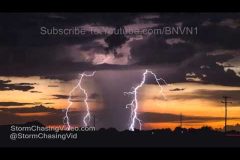
16-19. dramatic close lightning strikes near Harrisburg, NE
20-23. SLOW MOTION dramatic close lightning strikes near Harrisburg, NE
24 & 25. POV shot of dramatic tornadic supercell over Harrisburg, NE
26. metal siding from barn wrapped around utility pole with lightning in background near Bayard, NE
27-39. Derailed Train by possible broad tornado near Angora, NE
30. pushed-in shot of metal wrapped around utility pole in Bayard, NE
31. driving shot of debris and snapped power poles along road near Bayard, NE
32 & 33. shots of heavy tornado damage to barn near Bayard, NE
34. pushed-in shot of mud-covered sheep next to snapped power pole near Bayard, NE
35-37. shots of overturned semi-truck or tractor trailer near Angora, NE
38. pushed-in shot of roof damage to house in Bayard, NE from tornado
39. shot of snapped power pole near Bayard, NE
40-42. Various shots of highway blocked by flipped and damaged irrigation system near Bayard, NE
43-46. Various shots of overturned semi-trucks near Angora, NE
47. shot of downed trees blocking primary roadway in Bayard, NE from tornado
48. shot of house with damaged roof in Bayard, NE
Amazing footage of the Weld County Colorado tornado as the videographer drives up next to the tornado and tracks the tornado as it moves over the country side less then a mile away.
Shot Description
Clip 1 Tornado builds near Hereford Colorado
Clip 2 Tornado quickly gains strength and moved north along road toward Wyoming
Clip 3 Tornado crosses into Wyoming next to road
Clip 4 Tornado changes direction crosses road a couple of times
Clip 5 Tornado begins to rope out
A tornado warned storm and severe weather rocked the area just to the south of the Saint Cloud metro area this morning with extreme high winds and vivid lightning.
The footage starts out showing the tornado warned storm just to the south of the town of Kimball, MN with the Lightning, high winds and heavy rain hitting the area.
The second half of the video is the damage in Waite Park, MN where the area was slammed by straight line winds that damaged several homes and knocked power out to a large part of the Saint Cloud metro area.
Shot Description
First part is just south of Kimball, MN
Clip 1-3 Dramatic Time Lapse of the storm moving in.
Clip 4 – 14 Vivid lightning as the storm moves closer.
Clip 15 – 16 Driving in blinding rain.
Clip 17 Whiteout conditions
Clip 18 High winds cause tree’s to bend in the near whiteout conditions on Highway 15.
Clip 19 POV Lightning hits while driving.
**********************
Following footage is from Waite Park, MN of the storm damage and fire fighters on the scene.
Clip 20 Fire truck blocking the road
Clip 21 Fire truck and Xcel Energy on the scene of numerous power lines down.
Clip 21 Crews working on downed power lines.
Clip 22 Very wide shot of crews working on power lines as the lightning flashes across the sky in the back ground.
Clip 23 Waite Park Fire Chief directing traffic.
Clip 24 Tree branch through someones windshield
Clip 25 Tree on top of a house.
Clip 26 Trees on top of houses.
Clip 27 Tree on top of a house.
Clip 28 Tree on top of the house and another broken off by after being exploded by lightning.
Clip 29 Tree that exploded after being struck by lightning and landed on a house.
Clip 30 Damaged street light with an American Flag wrapped up in it.
Clip 31-32 Large pine tree resting on the power lines.
Clip 33-34 Large part of a tree on a house.
Clip 35-38 House with a large tree on it.
Clip 39 Debris in someones yard.
Clip 40 Fire crew blocking the road and large power lines down and tree down.
Clip 41-42 Power lines down.
Clip 43 Power lines down on power lines.
Clip 44 Flag blown down and laying in the street.
Clip 45 Tree laying on power lines.
Clip 46 Large billboard missing half the side of the structure. Pan to the right to see a huge section of the billboard that was ripped off and blown over 100 feet to the other side of the road.
Clip 47 Shot of the billboard and debris.
Edit Shot Sheet
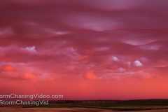
Amazing time lapse at sunset by Emmy Award Winning
Cinematographer Mike Olbinski of the Asperitas (formerly known as Undulatus asperatus) clouds at Sunset near Bowdon, ND.
Shot Description
Time Lapse scenes of the Asperatus as the golden hour of sunset moves over the landscape.
Music “Bayt Lahm” by Ryan Taubert, licensed through The Musicbed.
Video Copyright 6/2/2017 Mike Olbinski Photography http://www.MikeOlbinski.com and provided to StormChasingVideo.com LLC for News Video Distribution.
Powerful supercell with large wall cloud and baseball sized hail shatters windshield.
All footage shot near Clairemont TX during afternoon daylight on May 22, 2017 by Meteorologists Juston Drake and Simon Brewer
Shot Description
1-7. Shots of wall cloud changing shapes and approaching Clairemont TX
8 & 9. Pushed-in shots of baseball and golfball sized hail falling and bouncing off highway in Clairemont, TX
10. dark with SOUND of wind shield busting several times from baseball sized hail
11-14. shots of windshield continuing to bust and shatter from baseball sized hail near Clairemont TX
15-17. shots of shattered windshield from baseball sized hail near Clairemont TX
18-23. various shots of large wall cloud near Clairemont TX
Footage is from the intersection of Interstate 69 West and Mines Road. Not sure if there was a tornado or not, but there is a lot of RFD wind damage for sure.
Additional footage of extreme flooding.
Shot Description
Clip 1 Footage of extreme winds as we are stuck in traffic with RFD winds screaming past the vehicle and power is knocked out.
Clip 2 Extreme winds and flooding. The winds calm down but the flooding begins to get deeper as emergency services arrive on scene.
Clip 3 The road begins to look more like a raging river as vehicles try to navigate it.
Clip 4 Extreme flooding under an underpass.
Clip 5 Driving by storm damage as roofs are blown off in laying on the ground and utility lines are blown over.
Clip 6 Traffic light hanging from the overhead post.
Clip 7-8 Raw footage driving past the storm damage.
Clip 9 Flooded out road that is barricaded.
Live weather news video. There is a high risk of severe weather in Kansas and Oklahoma area today. SPC has issued a rare high risk severe weather outlook.
http://www.spc.noaa.gov/products/outlook/day1otlk.html
Live Track: https://goo.gl/oklaH3
See all streams LIVE and recorded: http://liveweather.tv
*** No Third Party Use w/o License ***
Copyright 2017 StormChasingVideo.com
*** NO THIRD PARTY USE W/O LICENSE ***
*** Contact StormChasingVideo.com for Licensing ***
SID=TeamH
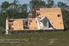
Daytime damage video after a wedge Tornado hit Canton Texas. Chainsaws and heavy equipment are needed to move massive trees laying on streets and homes. Neighbors help pickup up lost items from the damaged homes. SOTS with three people who survived the Tornado.
Shot Description
shot 1 wide shot from roof
shot 2 downed power pole
shot 3 large tree on house
shot 4 tight shot house damage
shot 5 pole workers
shot 6 power poles on ground
shot 7 wrecked car in field
shot 8 throwing logs on field
shot 9 damaged building and tree
shot 10 wide shot damaged farm
shot 11 uprooted tree
shot 12 pole damage
shot 13 roof damage
shot 14 destroyed building
shot 15 chainsaw
shot 16 tight chainsaw
shot 17 damaged car by house
shot 18 trailer house damaged
shot 19 neighbors hugging
shot 20 wide shot house damage
shot 21 tight shot people checking damage
shot 22 damage and traffic
shot 23 house damage
shot 24 house and tree damage
shot 25 business damage
shot 26 tree split
shot 27 car totaled
shot 28 sound Martha Weatheral
shot 29 jeff Hague
shot 30 Whitney hughes
Tornado stories from public first responders who witnessed storm and helped with search and rescue and a Edgewood, TX Fire department spokesperson
Shot Description
Shot 1: SOT Ashley Jones,Garden Valley TX resident
Shot 2: SOT Mark Hunter, Edgewood Fire Department
Shot 3: Medical personal at command post
Shot 4: Fire Officials at Fruitvale High School Tornado command post
Shot 5: Wide shot of EMS staging at Command post
Shot 6: Wide shot of Emergency personal
Shot 7: Wide shot of EMS outside
Shot 8: Command post view
Shot 9: Firetrucks responding on interstate