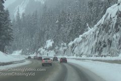
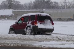
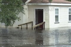
Fresh heavy mountain snow fall on and near I90 at Snoqualmie Pass Washington. Mountain snow and fog, snow play, snow plows, snow removal equipment, traffic in snow and slush.
Shot Description
Various shots of the fresh heavy snow around Snoqualmie Pass Washington. People interacting in heavy mountain snow, snow plows, traffic, burning snow donuts. Beautiful mountains scenes.
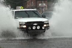
Video Footage From the Winter Storm Warning area of very heavy snow bursts of up to 2 inches per hour creating a travel nightmare in the Twin Cities with hundreds of Crashes and spin outs as well as major airport Travel delays at MSP!
Shot Description
Clip 1. A woman and 3 men struggle to push their large sedan backwards out of the ditch in a foot of snow on Interstate 35 in Minneapolis!
Clip 3. Woman pushing the car to no avail in the deep snow with tires spinning!
Clip 4. 4 people push car out of ditch by hand!
Clip 5. Major Crash with 4 cars and 1 SUV upside down on its roof with rescue on the scene.
Clip 6. Multi – Car crash on Interstate 35 in Minneapolis MN.
Clip 7. Car off roadway into deep ditch with trooper.
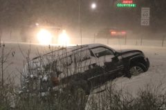
Clip 8. SUV sideways into deep heavy snowbank.
Clip 9. Car Fell down off of bridge above and into median below than into guardrail!
Clip 10. MNDOT Heavy snow plowing in tandem,
Clip 11. Snowplow closeup pushing powder snow and salting.
Clip 12-14. Twin Cities Snowplow operations and Cars with 8 inches of snow piled on top of them!
Clip 15. MSP Airport De-Icing Pad with snowy takeoff,Snow Gang Plows,and a landing in the shot!
Clip 16. Runway shutdown with ground stop under heavy snow.
Clip 17. Slippery landing in dense heavy snow at MSP.
Clip 18-20 Snow removal operation at Minneapolis Airport.
Video Footage from Far Southern Minnesota from late this Saturday afternoon of the heavy snow bands that caused severe wrecks and travel troubles as it slowly stalled out over the interstate I-90 corridor!
Shot List:
Clip 1. Train coming straight at the camera in heavy snow and blowing snow with gigantic snow flakes!
Clip 2. Train passby POV.
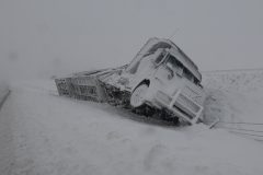
Clip 3. Truck smashed into the Bridge and sitting wrong way in the middle of I-90.
Clip 4. Truck blocking I-90 in the middle of an ice covered bridge seconds after it happened.
Clip 5. Emergency respondents arrive on scene and render air to the victims.
Clip 6.Close POV of Fast moving snow plow shooting up a massive roostertail of powder snow high into the air!
Clip 7. Heavy snow falling in Windom, MN.
Clip 8-10. Giant Snowflakes falling in Jackson Minnesota .
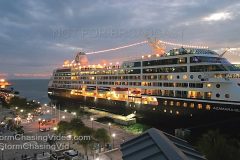
The new cruise ship dock is now open at Mallory Square in Key West Florida and our partner cam is capturing some incredibly beautiful scenes in HD as well as time-lapse video of people escaping the cold on cruise ships to Key West FL. This video features the Canadian vessel “Azamara Quest” beautifully lit at sunset and departing the dock Friday night. Includes normal HD and time-lapse clips.
Shot Description
1) Azamara Quest at new dock Mallory Square dock in Key West at sunset Friday night.
2) Time-lapse video from late afternoon through, sunset and departure of the Azamara Quest.
3) Azamara Quest departing dock and blowing its very loud horn.
4,5) Azamara Quest arriving at dock in Key West early Friday morning.
6) Azamara Quest at dock during day.
7,8,9) Beautiful colorful shots of Azamara Quest backlit by sunset skies and ship lights.
10) Azamara Quest lit up at night at dock.
Footage of blizzard conditions burying Village of Lorraine, NY. Cars and houses nearly completely buried under 3 feet of snow with 7 foot snow drifts reaching up houses. Snow up to windows and tops of doors. High winds blowing heavy snow making nearly whiteout conditions. Tractor trailers wrecked on side of Interstate 81 from heavy snow. Shot of deer crossing roadway leaping through deep snow. Footage of Meteorologist Simon Brewer measuring 37 inches of snow depth near Lorraine.
All footage shot during evening daylight & darkness on November 21, 2016 in/near Lorraine, NY by Meteorologist Simon Brewer.
Shot Description
Shot List:
1. pushed-in shot of several deer crossing snow-covered road and leaping through very deep snow near Lorraine, NY
2-4. Shots of high winds blowing snow around house & barn with snow almost touching roofs near Lorraine, NY
5. Shot of near buried vehicle and house with winds roaring, blowing snow
6. pushed-in shot of blowing snow with giant ice cycles on house
7 & 8. shots of truck plowing driveway of house
9. pushed-in shot of car with huge snow cornice surrounded by deep snow
10-12. shots of blizzard conditions from high winds blowing snow with nearly whiteout
13 & 14. shots of car trapped in deep snow
15. pushed-in shot of mound of snow on mailbox
16 & 17. Pushed-in shots of two cars nearly buried in deep snow
18. POV shot with “AUDIO” of Meteorologist Simon Brewer measuring 37 inch snow depth with 36 inch yard stick. Yard stick goes into and below surface of snow.
19 & 20. Images (selfies) of Meteorologist Simon Brewer waist-deep in snow when trying to take measurements near Lorraine, NY
21. pushed-in shot of traffic on snow-covered road with blowing snow from high winds and snowdrifts moving onto road
22. POV driving shot of mult-semi-truck accident where 3 tractor trailers were wrecked off side of Interstate 81 from heavy snow
23. pushed-in shot of fire station with snow nearly up to top of front door
24-30. Various shots of houses and cars nearly buried under deep snow
31. wide shot of town with blowing snow from high winds
32. shot of small evergreen tree covered in deep snow with other snow-covered trees in background
33 & 34. POV driving shots of heavy snow falling and trees caked in snow
35. pushed-in shot of front loader trying to clear snow in Lorraine, NY
36. POV driving passing nearly buried vehicles in front of houses
37. POV driving shot of snow drifts encroaching on roadway near Lorraine, NY
Winter finally pays the northeast a visit. People out and about struggling against very strong winds and the coldest air of the season so far in Hoboken, NJ.
Shot Description
Scenes 1-2: People out and about on River Street in Hoboken, NJ struggling against very strong winds.
Scene 3: Papers and other trash being blown all over the street in high winds on River Street in Hoboken.
Scene 4: Timelapse sequence of storm clouds racing over the lower Manhattan Skyline, and Freedom Tower.
Scene 5: American flag blowing in strong winds
Scene 6-7: People out and about on River Street in Hoboken, NJ struggling against very strong winds.
Scene 8: A row of small American Flags blow in the strong winds, as pedestrians walk by bundled up from the sudden winter chill.
Scene 9: A mother pushes her baby carriage across River Street, and struggles against strong cross winds.
Scenes 10-11: People out and about on River Street in Hoboken, NJ struggling against very strong winds.
Scene 12: A street sign is blown around in strong winds in Hoboken.
Scenes 13-17: People out and about on River Street in Hoboken, NJ struggling against very strong winds.
New 4K Footage from Saint Cloud to Sauk Centre, MN along Interstate 94, Highway 71 and Highway 28 of the blizzard conditions.
Shot Description
Clip 1 Car spun out on Interstate 94
Clip 2 Car spun out on Interstate 94
Clip 3 -5 A Semi Truck Car Carrier that flipped over on its side and crashed and crashing and smashing at least eight different new vehicles inside the wreckage.
Clip 6 Long wide clip of several semi trucks stuck in the center median and one trying to get pulled out.
Clip 7 Tight shot with blowing white out conditions of the footage in clip 6
Clip 8 Car crashed into the center cables.
Clip 9 Car Crashed into the center cables.
Clip 10 Interstate 94 was covered with at least a couple of inches of packed ice in some spots and mostly covered with a half inch to an inch of ice in most spots in western Stearns County.
Clip 11 Semi Truck that went off the road.
Clip 12 Huge flag blowing in the wind.
Clip 13 POV shot of a road grader being used to plow Highway 71 and scrap off the ice that has packed onto the road surface.
Clip 14 – 15 Wide and tight POV shots of a snow plow on Highway 71 with the blizzard conditions blowing snow.
Clip 16 Blowing snow in the tall grass along Highway 71
Clip 17 Blowing snow on Highway 71
Clip 18 POV Driving in whiteout conditions
Clip 19 Blowing snow on Highway 71
Clip 20 Blowing snow on Highway 28
Clip 21 Car driving towards the camera on Highway 28 in the blowing snow.
Clip 22 White out conditions on Highway 28
Clip 23 Pickup Truck stuck in the snow off of Highway 28
Clip 24 – 25 POV Driving in whiteout conditions on Highway 28
Clip 26 State Trooper with a minivan that spun out on Interstate 94
Clip 27 Car carrier that crashed from the other side showing the cars and suvs on their sides in the back.
Clip 28-29 Jack Knifed Semi Truck on Interstate 94 being pulled out
Clip 30 Car in the ditch
Clip 31 -32 Jack Knifed Semi Truck in the ditch on Interstate 94 and Highway 15
Footage of the Truly Dangerous and Intense Blizzard Crippling Modern Day Travel Today in Western Minnesota!
Shot Description
1. WHITEOUT Blizzard with true Zero Visibility and 60MPH Winds.
2. MNDOT Snow Plow Breaking a Trial on MN HWY 28 near Graceville MN.
3. Car off the Road in Stevens County MN with a Truck Towing out.
4. Snow Plow Passing By POV in Blizzard.
5. Large Heavy Snow Equipment Plowing deep 2 ft drifts in Morris MN.
6. Signs bending in the strong violent winds.
7. People shoveling Snow in Graceville MN.
8-14 Winter Storm Winds and Snow POV’s
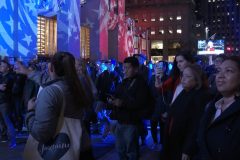
People in NYC reacting to the presidential election results coming in, along with several interviews with Donald Trump supporters.
Shot Description
Shot 1-2: People rallying for Trump on 6th Avenue in Manhattan. An African American man explains why he supports Donald Trump for President.
Shot 3: A man flying a “Don’t Tread On Me” flag, walks across 6th Avenue in Manhattan.
Shots 4-5: A middle aged man explains why he supports Donald Trump for President.
Shot 6: A young man wearing a Donald Trump banner is cursed at by a man off camera as he walks across 6th Avenue in Manhattan.
Shots 7-10: People rallying for Donald Trump explain why they are supporting him for President.
Shots 11-17: People in support of Hillary Clinton for President rally together at Rockefeller Center in Manhattan.
Shot 18: The NYPD Counter Terrorism Unit assembles at Rockefeller Center.
Shot 19: A woman holds up a sign denouncing Donald Trump across the street from Trump Tower on 5th Avenue in Manhattan.
Shot 20: An NYPD vehicle is stationed with it’s lights on, across the street from the Hilton on 6th Avenue.
Shot 21: A young man holds up a sign in support of the 2nd Amendment that reads “Come And Take It”
Shots 22-23: Trump and Hillary Clinton supporters gather on 6th Avenue, to watch the election results roll in.
Shot 24: An Arab American checks the election results on his smartphone
Shot 25: Large crowds gather at Rockefeller Center to watch the election results roll in.
Shot 26: The NYPD Counter Terrorism Unit assembles near the Hilton Hotel on 6th Avenue.
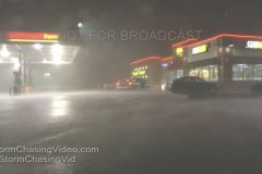
Severe high winds from Late Fall severe storms knock out power in town of Lamar in Clinton County, PA. Footage of severe high winds, frequent close lightning, small hail, and heavy rains in Lamar, PA. Tractor Trailers and cars from I-80 in Central PA exit highway into dark town to take shelter from the severe storms.
All footage shot during evening darkness in Lamar (Clinton County) PA on October 20, 2016 by Meteorologist Simon Brewer.
Shot Description
Shot List:
1. Wide shot of lightning flashing over truck stop off I-80 in Lamar, PA as severe storm bears down on town
2. pushed-in shot of heavy rain hitting pavement at truck stop in Lamar, PA as severe storm begins to hit town
3. wide shot of high winds and heavy rain starting to hit truck stop in Lamar, PA
4-7. various shots of severe high winds slamming truck stop in Lamar, PA with lighting flashes
8. pushed-in shot of severe high winds blowing past gas pumps when power is knocked out in town of Lamar PA
9 & 10. cars exit I-80 attempting to take refuge from severe storm in dark town of Lamar with severe high winds still pummeling truck stop
11-15. Various shots of close lightning strikes with thunder and some commentary on audio at truck stop with power out in Lamar, PA
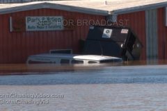
FOOTAGE of flooded homes, cars, and businesses from the “Tar River” and its tributaries in Rocky Mount, NC following the historic heavy rainfall from Hurricane Matthew.
Also shots of a “Jeep” driving through a long stretch of deep flood water.
All footage shot during evening daylight in Rocky Mount, NC on October 9, 2016 by Meteorologist Simon Brewer.
Shot Description
Shot List:
1 & 2. Shots of major road turned into a river in Rocky Mount, NC
3-6. Various shots of risky “Jeep” charging through long strip of deep flood waters while onlookers can’t believe what the saw in Rocky Mount, NC
7-9. shots of homes in flood waters in Rocky Mount, NC
10. car in deep flood water in Rocky Mount, NC
11. pushed-in shot of auto shop flooded in Rocky Mount, NC
12 & 13. Shots of submerged van and floating dumpster in front of Auto Shop in Rocky Mount, NC
14-16. Various shots of raging flooded “Tar River” and old rail bridge hit from bellow by flood in Rocky Mount, NC
17. building in flood waters
18. pushed-in shot of door broken open by force of flood waters in Rocky Mount, NC
19-22. Various shots of homes and businesses flooded by Tar River in Rocky Mount, NC
23. pushed-in shot of “Paws Inn” flooded puppy kennel in Rocky Mount, NC
24. pushed-in shot of “Rocky Mount” business sign in flood water
25. shot of “Paws Inn” and “Rock Mount” signs in flood waters
26-30. Various shots of flooded businesses in Rocky Mount, NC
31. pushed-in shot of cars in flood water in Rock Mount, NC
32. wide shot of car dealership flooded in Rocky Mount, NC
33. pushed-in shot of “Jeep” in flood waters
34 & 35. Shots of businesses in deep flood water in Rocky Mount, NC
36-38. Shots of vehicles driving through flooded river over road in Rocky Mount, NC.
39 & 40. Utility crews work with basket truck to restore power to towns cut off by Hurricane Matthew
41 & 42. Shots of large tree down on powerlines and highway
44. shot of flood waters surrounding this restaurant
45. panning shot of flood waters surrounding factory and very close to I-64 in Rocky Mount, NC
Footage of cars driving through flash floods, cars trapped in flood water, homes and businesses in flood water, large snapped trees, trees on power lines, high wind damage, power flashes, high wind-driven rain, etc. Hurricane Matthew interacted with a front over North and South Carolinas causing an explosion in storm development, which intensified the pressure gradient and associated extremely high hurricane force winds over Myrtle Beach, SC and Wrightsville Beach, NC.
All footage shot in/near/between Myrtle Beach, SC and Wrightsville Beach, NC during afternoon daylight and evening darkness on October 8, 2016 by Meteorologist Simon Brewer.
Shot Description
Shot List:
SHOTS 1-36 from near/in Myrtle Beach, SC
SHOTS 37-50 from in Wrightsville Beach, NC
1 & 2. Shots of gas station fuel pump area heavily damaged by high winds near Myrtle Beach, SC
3-6. various shots of vehicles and businesses under water from flash flooding in Myrtle Beach, SC
7-10. Large mature pine trees snapped near base from very strong near to over hurricane force winds in Myrtle Beach, SC
11. Pushed-in shot of damaged fallen McDonalds sign from high winds in Myrtle Beach, SC
12-14. various shots of trucks driving through flash flood waters over Highway 17 near Myrtle Beach, SC from flash flooding
15-23. Various shots of homes and business hit by flash flooding near Myrtle Beach, SC
24-32. Various shots of large trees down on Highway 17, down on powerlines, and utility crews near/in Myrtle Beach, SC from high winds
33. Billboard knocked over from high winds near Myrtle Beach, SC
34-36. Shots of traffic lights violently swaying in high winds and traffic light destroyed on ground in Myrtle Beach, SC
-REMAINING SHOTS (37-50) ARE ALL FROM WRIGHTSVILLE BEACH, NC-
37-39. Shots of EXTREME winds in Wrightsville Beach, NC
40 & 41. Shots of large powerflashes lighting sky over Wrightsville Beach, NC
42-45. Various shots of high winds and wind-driven rain in Wrightsville Beach, NC
46-50. Shots powerline sparks/short causing flame at pole and simultaneously causing lights to flicker in adjacent home in Wrightsville Beach, NC
Footage of beach erosion, heavy surf, and blowing trees in high winds on Jupiter Beach, FL as Hurricane Matthew spins off shore.
All footage shot during evening daylight at Jupiter Beach, FL on October 6, 2016 by Meteorologist Simon Brewer
Shot List:
1-3. various shots of waves causing beach erosion on Jupiter Beach , FL in advance of Hurricane Matthew
4-6. various shots of heavy surf causing beach erosion on Jupiter Beach, FL
7 & 8. various shots of palm trees blowing in high winds as feeder bands pass over Jupiter Beach from Hurricane Matthew
9. pushed-in shot of heavy surf at Jupiter Beach as Matthew approaches
10-12. various shots of palm trees blowing in increasingly higher winds from Hurricane Matthew
New pre storm B-Roll from the expected Ground Zero for the eye of Hurricane Matthew in Cocoa Beach, FL. Various clips of the area before the storm with shops boarded up and the storm moving in.
Shot Description
Clip 1-4 Areal view of the beach on Cocoa Beach of the waves.
Clip 5 – 6 Palm Tree Blowing In The Wind and Rain
Clip 7 10 Port Canaveral EMPTY
Clip 11 – 15 B-Roll Ron Jons
Clip 16-25 Shops boarded up
Clip 26 – End, Various B-Roll of the heavy rain and tropical storm force winds that are moving into the area.
B-roll footage of some of the pre Hurricane prep work prior to the major Hurricane Matthew making landfall in the next 36 hours on the east coast of Florida.
Shot Description
Clip 1 Cocoa Beach Florida looks more like a ghost town as all of the tourists were asked to leave and hotels were forced to kick out existing guests. Shot of a massive Hilton Hotel with an empty parking lot.
Clip 2 Wide shot of the signs on a local IHop saying Florida is closed.
Clip 3 Tight shot of the sign saying Florida is Closed.
Clip 4 -6 Shot at a Walmart in Orlando where residents are clearing out the shelves like it was Black Friday.
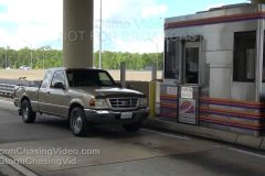
Clip 7 Sign on one of the toll booths saying Tolls Suspended
Clip 8 Cars going through the toll booth without paying
Clip 9 Traffic
Clip 10 Traffic
Clip 11 -13 Board up operations at a local business
Clip 14 Tight shot of the sing saying Thanks Matthew, Not Today.
Clip 15 – 16 Beach and waves
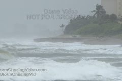
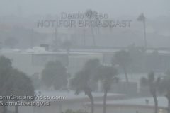
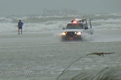
Siesta Key Beach storm surge surprises everyone as it arrives early during the noon hour as heavy squalls from Tropical Storm Hermine bring in the storm surge, high wind and heavy rain. Lots of B-Roll of storm surge, wind, rain, people in storm. Lifeguard vehicles in storm surge at the beach.
Shot Description
Clip 1 Beach Patrol driving through the storm surge.
Clip 2 People out on the beach in the storm surge next to a closed down life guard shack.
Clip 3 People checking out the high winds and storm surge from the grass on the dune.
Clip 4 People in the high winds and surge on the beach.
Clip 5 Long shot down the beach as the storm surge is overtaking over the whole coast line.
Clip 6 Someone trying to walk in the surge and high winds with a boogie board.
Clip 7 People leaving the beach.
Clip 8 More surge
Clip 9 Life guard shack in the surge.
Clip 10 Beach patrol trashing their vehicle by driving it in the salt water storm surge.
Clip 11 Someone walking to the beach wearing a garbage bag to protect them from the rain.
Clip 12 Close up of shack in the surge.
Clip 13 Swimming Warning Buoy washed on shore.
Clip 14 Storm Surge.
Clip 15 Storm Surge all the way up to the entrance of the beach.
Clip 16 Storm Surge.
Clip 17 No Swim Advisory warning sign.
Clip 18 Storm Clouds rolling in.
Clip 19 Large wave and surf.
Clip 20 Palm trees blowing in the wind.
Clip 21 Heavy rain falling.
Clip 22 Palm trees blowing in the wind.
Clip 23 Palm trees blowing in the wind.
Clip 24 Palm trees blowing in the wind.
Heavy rain from thunderstorms over central Minnesota cause several areas of flash flooding. In the city of Foley, MN where the residents reported they received over five inches of rain in just a couple hour’s, the flash flooding was several feet deep along highway 23. Several homes reported flooding in their basements and highway 23 has been shut down until the water recedes.
Shot Description
Clip 1 Flash flooding that looks more like a river rapids over highway 23.
Clip 2 Flash flooding and a road closed sign in the water.
Clip 3 Police car blocking the road
Clip 4 Pickup truck trying to get out of the rushing water.
Clip 5 SOT with Correy Rueckert talking about how he has never seen it this bad.
Clip 6 Rushing water over the road.
Clip 7 Police and store manager walking in the rushing water.
Clip 8 People looking at the flooding while standing in the water.
Clip 9 Water filling the Casey’s parking lot.
Clip 10 Several feet of water over Highway 23 as crews block the road.
Clip 11 Looking northeast at several feet of water over Highway 23.
Clip 12 Flood waters overtaking Frandsen Bank and Truck on Highway 23.
Clip 13 – 14 B-Roll of cloud lowering north of Foley, MN.
Clip 15 – 16 POV footage driving in heavy rain before the flooding
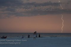
An intense and spectacular lightning storm over the Gulf of Mexico and barrier islands brought out the spectators at Siesta Key Beach in Sarasota County Florida Sunday night. Many shots of CG, crawler, and inter-cloud illuminating lighting over the water, beach, and skyline. Time of events spans from just before sunset, to well into after dark.
Shot Description
There are too many shots to individually describe. All shots from Siesta Key public beach. Don’t miss the amazing crawler lightning at TC 2:27.
1-9) Nine shots from on the beach near sunset time with spectacular CG strikes behind condos, into water, with many people watching the show from the beach.
10-13) Four elevated shots of CGs into the water with many people on the beach watching.
14-16) Three CGs strikes into water.
17-26) Ten clips of CG, flash, and crawler lightning as dark approaches.
27-31) Five clips of crawler lightning after dark.
32-81) Approx 50 clips of after dark lighting over water to the west, and over skyline looking north. Includes many CG, inter-cloud, and some crawler lightning.
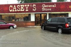
After the morning line hammered Caterville and surrounding areas, another line of storms formed to the north, leaving a very narrow, but powerful aftermath in the wake of almost 5-inches of rain in less than two hours. The town of Tamaroa, north of Du Quoin in Perry County, took the brunt of this storm. Residents and emergency officials said this is the worst they had ever seen, dating as far back as 30 years. The water covered US-51 in several areas between Du Bois and Du Quoin, but just south of Tamaroa was where the worst came. Tamaroa is situated on US-51 about an hour southeast of St. Louis in Perry County, Illinois. Du Quoin is approximately 5 miles south on US-51.
After the rains lightened up, water continued to rise, leading several cars to get stalled as they drove through water that earlier cars were able to make it through. Nearby residents came to their aid, helping to push cars from the rising water.
Perry County Sheriffs arrived on-scene and closed down US-51 to all traffic, diverting them around on not as badly flooded back roads. The road was closed til at least 6pm, but the water was receding.
In total, two cars were stalled and had to be towed away from the area. No injuries were reported.
In town, the Caseys took on significant flooding, which also spilled out onto US-51 causing traffic delays less than a mile north of the closure. Water as high as a foot inundated the parking lot, and had people wading through ankle-to-knee deep water to get to the pumps and store entrance. Other than a little inconvenience, most customers navigated the waters fine, at least until they tried to go south to Du Quoin.
Shot Description
Runtime of 7:28 includes three different SOTs edited down at end of clip. They are as follows..
6:11-6:45 Tony Jones, Perry County resident
6:46-6:59 Lynn Buckmaster, Perry County Resident
7:00-7:28 Kelsey Lamke, Tamaroa Resident
Scene 1: Perry County Sheriff arriving on scene to close US-51 at Tamaroa.
Scene 2: Kelsey Lamke walking across flooded US-51 with traffic stopped in the flash flood waters. The Tamaroa city sign in the background.
Scene 3: Wide shot with Kelsey standing in the water with stopped traffic behind her.
Scene 4-5: Shot looking straight down US-51 into Tamaroa as oncoming traffic closes in on flood waters. Transitions to those cars passing through water.
Scene 6: POV shot out windshield as white van stalls in high waters in the northbound lanes. Behind it, a black car stalls in the southbound lanes.
Scene 7: Woman walking toward two stalled cars.
Scene 8: Woman approaches driver side of stalled white van.
Scene 9: Another man approaches van from behind.
Scene 10: Shot of woman and man pushing van as black truck passes, zooms in and out during longer shot.
Scene 11: Shot as van gets pushed by three people with two others walking along side it.
Scene 12: Woman carrying a small dog through flood waters.
Scene 13: Pickup truck passes stalled van with two woman following on foot behind it.
Scene 14: A long shot of a red pickup truck in heavy rains driving through water that goes over the hood while creating a large white cap in the flood waters. This was a side road off US-51, driver getting around closure and barely makes it through this.
Scene 15: Wide shot of scene before closure as several vehicles await to pass through water with three woman walking along flooded shoulder.
Scene 16: Tight shot of oncoming cars driving through water that almost gets up over the hoods.
Scene 17: Tight shot of three cars driving away from camera through US-51 flood waters.
Scene 18: Medium shot of three oncoming cars driving through flood waters.
Scene 19: Wide zoomed shot of flooded US-51 on the north side of Tamaroa.
Scene 20: POV shot of US-51 in the town of Tamaroa in front of the flooded Casey’s gas station.
Scene 21: Black van plows through parking lot flood waters and parks in front of store, cresting a small wave against the building.
Scene 22: Shot looking at Caseys building with cars parked right up to the wall.
Scene 23: Black car quickly exits flooded parking lot.
Scene 24: Woman standing in knee-deep water behind an SUV in the parking lot flooding.
Scene 25: Two people crossing the flooded parking lot.
Scene 26: Three teenagers walking from the flooded parking lot with grocery bags.
Scene 27: Driver of maroon SUV stands on island while authorizing gas pump.
Scene 28: Zoomed shot from driver out to his car in the flooded parking lot as passenger in the car leans out and takes cell phone picture.
Scene 29: Man walks from front doors to his pickup truck in ankle-deep water as an SUV pulls into frame.
Scene 30: A man gets out of a red car and opens his vehicle’s gas cap while standing in ankle-deep water.
Scene 31: Shot of red car at pump in flood waters.
SOTs listed above begin here.
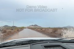
Monsoon action near Quartzsite, Arizona. Rainfall miles away can cause flash flooding in clear skies.
Shot Description
Shots of the changing monsoon weather and a flash flood between Yuma, AZ and Quartzsite, AZ along highway 95.
Strong storms with heavy rains developed across southern Illinois on Monday afternoon offering the first real break from the hot weather that lead to a weekend-long excessive heat warning. Stormy weather is expected to continue across the region all week as a front moves into the region and stalls out. While severe weather won’t be a huge concern, heavy rains will, but more than anything, these storms will offer a much welcome break from the heat.
Shot Description
Scene 1-2: POV driving shots in the rains.
Scene 3: POV driving shot following vehicles into street flooding area in Du Quoin.
Scene 4: Pickup truck driving at camera and turning off camera in the heavy falling rain.
Scene 5: Car sitting in the parking lot of a shopping center in the heavy falling rain.
Scene 6: Two vehicles turn through flooded street as heavy rain falls.
Scene 7: Shot of white SUV driving through flood waters.
Scene 8: Wide shot of cars driving through flood waters on US-51 in Du Quoin.
Scene 9: Traffic passing through flood waters.
Scene 10: White truck blasts through water while other cars slowly make their way into the flooding.
Scene 11: Oncoming black car driving down a flooded side street.
Scene 12: Long shot of traffic driving through flood waters.
Scene 13: Shot of traffic driving through flood waters in front of a Hardees.
Scene 14: Panning shot of red car driving through flood waters.
Scene 15: Ameren Illinois utility truck driving through flood waters.
Scene 16: White van driving through flood waters.
Scene 17: Wide shot of the flood waters in front of Hardees.
Scene 18: Semi trucks driving through flood waters.
Scene 19: Shot of shopping center parking lot with standing water.
Scene 20: Shot of shopping cars in standing water.
Scene 21-22 (Franklin County south of Benton, IL): Shots of a semi truck that crashed in the ditch on I-57, accident blamed on weather as the storms moved over the interstate.
Scene 23: Down tree on a road outside of Benton, IL
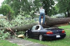
Clean-up continued across Massac County, Illinois after an early afternoon round of storms hammered the region. Video package shot in the late afternoon/early evening hours as crews arrived on scene to start clearing the debris left behind by straight line winds and an unconfirmed tornado.
Shot Description
Scenes 1-5: A Metropolis Superman standing on the roof of a car smashed under a massive tree chainsaws the tree to get it off the car.
Scene 6: Close shot of smashed car under tree.
Scene 7: Shot of front of car smashed under tree.
Scene 8-9: Shots of inside of car with roof crushed nearly to seats.
Scene 10-16: Shots of crews clearing trees from powerlines that snapped several power poles, knocking out power to most of the town.
Scene 17-20: Shots of lifters taking tree debris from roads.
Scene 21-22: Shot of workers removing down power lines.
Scene 23: Shot of a crosswalk sign crushed beneath tree.
Scene 24: Shot of tree smashing front end of home.
Scene 25: Shot looking down street of down trees and power lines.
Scene 26: A Massac County business with its roof completely gone.
Scene 27: Down sign on US-45 in Massac County.
Scene 28: Part of a roof in a parking lot near the interstate in Massac County.
Scene 29: Damage to a gas station roof near the interstate in Massac County.
Scene 30: Cops directing traffic at an intersection with no power to traffic lights.
Scene 31: Shots of dark intersection with traffic.
Scene 32: Tight shot of traffic light with no power.
Scene 33-34: Shot of a traffic light damaged and hanging by its wiring.
Scene 35: Shot of interstate sign bent over.
Scene 36-37: Humorous shots of Superman and Wonder Woman tourist traps with no heads, meaning they lost their heads with how powerful the storm was (Metropolis)
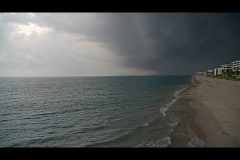
NWS alerted of rotating storm moving SW to NE across Palm Beach county Florida at 1:08PM. Our PTZ camera placed at the William O. Lockhart Municipal Pier in Lake Worth captured the dramatic video as the storm moved out over the Atlantic ocean. Including timelapse video and real-time clips before, during, and after the storm.
Shot List:
1) Timelapse as storm moves offshore Palm Beach Florida over the Atlantic Ocean.
2,3,4,5) Shot only 30 minutes before of the sunny delightful conditions with people enjoying the pier, water, and beach.
6) Storm approaching the coast.
7) Heavy rain and lightning hits the coast.
8) Heavy rain hits the pier.
9,10) Deserted beach and ocean as storm moves away offshore.
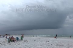
TD #3 has become Tropical Storm Colin. Effects of Colin reached Southwest Florida later afternoon and ramped up significantly after sunset. The video begins with the most recent shots just after sunset as a very heavy squall came ashore Siesta Key Florida bring extremely heavy wind driven rain that quickly flooded roads causing dangerous driving conditions on island roads. At timecode 2:26 and after clips showing conditions prior to sunset as the effects of the growing storm reached the beach, and people were interacting with the windy conditions and high surf late Sunday afternoon.
Shot List:
Tropical Storm Colin affects southwest Florida Sunday evening with intense squalls pounding Siesta Key with wind and rain.
Shot List:
1,2) Squall band nearing Siesta Key Beach just after sunset.
3 – 12) Ten varied shots of heavy wind driven rain from a tropical squall pounding a lighted Siesta Key Beach public area.
14 – 20) Seven shots of vehicles plowing through flooded Beach Rd on Siesta Key at night as heavy rain continues to fall.
21) Traffic in Siesta village and lightning.
— Begin Day light shots —
22) Big dark squall line approaching beach.
23) Wind blows palm tops with beach in background.
24) Boys trying to roll up a tarp in high wind on beach.
25) Beach canopy destroyed by wind.
26) Flags blowing in wind.
27) Swim buoy in high surf.
28) Kids playing with towel in wind like a parachute.
29) People walk through frame w/ high surf in bkground.
30) Young women in high surf.