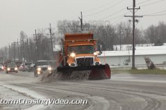
The major winter storm moving across the country began making its impacts felt across southern IL as moderate amounts of sleet came down through the day on Thursday. Sleet in some places looked almost like snow and even brought out the snowplows to clear off roads as drivers slowly navigated area highways. This is only the beginning across the region as more ice and snow are expected to create even worse conditions by Friday afternoon.
Accumulations of sleet and ice have reached as high as a quarter-inch in areas with I-DOT reporting many ice covered roads in Jefferson, Perry, and Jackson Counties.
Shot in Carbondale, Illinois in Jackson County which sits roughly an hour from Cape Girardeau, MO and Mt. Vernon, IL. It is 100 miles south/southeast of St. Louis.
Scene 1: Establishing shot of backed up traffic going into Carbondale on US-51 with sleet covering the highway.
Scene 2: Long shot of an oncoming snow plow clearing the sleet from the roads with traffic behind it.
Scene 3: Shot as snowplow leaves Carbondale clearing sleet from the highway.
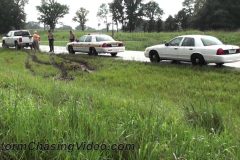
Scene 4: POV drive shot of a vehicle that slid off the sleet-covered highway just north of the Carbondale city limits. Pans to highway patrol car parked on shoulder.
Scene 5: View looking through falling sleet of highway patrol car and oncoming traffic.
Scene 6: Shot along US-51 north of Carbondale with traffic driving on sleet-covered road.
Scene 7: POV drive shot along US-51 north of Carbondale showing oncoming traffic, falling sleet.
Scene 8: Shot in Carbondale showing large amounts of sleet on roadways.
Scene 9-10: Shot of UPS driver delivering packages in moderately falling sleet.
Scene 11-13: Shot of vehicles with dark tinted windows and surfaces showing ice and sleet that has accumulated on vehicles in Carbondale.
Scene 14: Zoomed shot looking at trees with sleet falling.
Scene 15: Shot from inside vehicle as windshield wipers come on trying to clear the sleet from the windshield.
SID: Tony Laubach
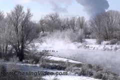
Arctic cold gripped the Denver, Colorado metro region early Thursday morning December 05, 2013. A record low temperature of -15 degrees was recorded at Denver International Airport shortly before daybreak. While temps moderated by late morning, the cold still held the Denver area residents and wildlife in its icy grip.
Video highlights include furnace exhaust vents, power plants, electrical power plant, temperature readings, waterfowl, South Platte River fog, construction workers, and area shoppers.
SID: Ed Grubb
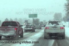
Video package featuring the afternoon Twin Cites Metro area Rush Hour evening commute at the height of the heavy snowfall and sleet.
Package starts out on I-694 in the northern part of the metro area, with a 6 unit MNDOT gang plow group covering 4 lanes and clearing heavy snow as shot from above the scene.
video than follows including multiple stuck and spun-out vehicles as well as local significant impacts to traffic and snow removal efforts.
A strong arctic air mass moved into the Denver, CO metro area late Tuesday evening, December 03, 2013, bringing with it near zero temperatures and moderate snow. The video highlights Wednesday morning’s rush hour with slow traffic and the continuing snow removal efforts. The Denver area averaged around three inches of snow by daybreak on Wednesday morning with snow continuing to fall.
SID: Ed Grubb
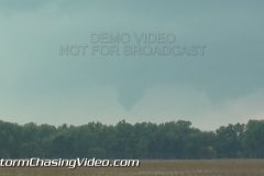
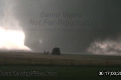
Demo footage of the TIV2 from the show on Discovery Channel Storm Chasers in action from the fall of 2013.
B-Roll footage of the TIV2 showing how the crew deploys the vehicle for a tornado intercept.
TIV2 was created to be an armored camera platform for an IMAX camera to film inside of a tornado for the IMAX movie Tornado Alley and was also one of the starts of the show Storm Chasers on the Discovery Channel.
Footage no longer available for licensing.
Catalog ID: TIV2_DEMO_BRoll
Video © Doug Kiesling – StormChasingVideo.com
Live stream from Siesta Key Beach starts at 5pm EST on Dec 1, 2013. Sunset is at 5:34pm. Siesta Key Beach Sarasota FL.
SID=BrianD
Tony Laubach was on the major severe weather outbreak as it unfolded today across the Great Lakes and Ohio Valley that brought dozens of tornadoes, high winds, and even extremely large hail to the region. In this B-Roll video, it shows the storms that battered Illinois and Indiana.
Video package includes clips from THREE storms… please note the locations in the description below.
0:00-2:49 Lebanon, Indiana
2:50-4:00 Veedersburg, Indiana
4:01-5:19 Bloomington, Illinois
0:00-2:49 Lebanon, Indiana
Package opens up with various shots of the Lebanon tornado as it moved into town. Subsequent shots of a Starbucks that was heavily damage on the south side of Lebanon due to the tornado. A vehicle flipped on its side with the front part of the store blown in.
2:50-4:00 Veedersburg, Indiana
A possible tornado hit the small town of Veedersburg, IN and destroyed one mobile home and damaged several trees. Video package includes shots of the destroyed mobile home as well as some of the tree damage in town.
4:01-5:19 Bloomington, Illinois
Video opens up with high winds, rain, and hail pummel the city during this tornado-warned storm. Shots of extremely high winds, some tree damage, and a tennis-ball sized hailstone that cracked the windshield of a vehicle. Shots also of cars in ponding, vehicles pulled off under an overpass on the interstate, and a tree blocking a Bloomington neighborhood road.
SID: Tony Laubach
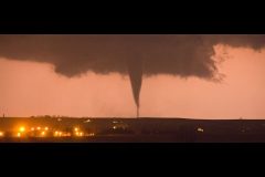
*** First live tornado ever to be streamed on YouTube LIVE. *** Nov 17, 2013
Fast Forward to time code 4:27:00 to get to the good shots of the Tornado.
Storm Chasing Video meteorologist Tony Laubach is LIVE and mobile covering the expected severe weather event in the mid-west US Nov 17, 2013.
SPC FORECAST: …THERE IS A HIGH RISK OF SVR TSTMS OVER PARTS OF
ILLINOIS…INDIANA…WESTERN OHIO…AND SRN MICHIGAN…
Live Tracking Map:
http://www.livenewsvideonetwork.com/scvp/scv-stringers/tony-laubach/live-track/
** ALL RIGHTS RESERVED. NO THIRD PARTY USE OF STREAM CONTENT W/O LICENSE **|
SID=TonyL
TVID=TWC,CNN
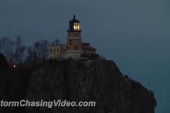
The historic Split Rock Lighthouse was packed with hundreds of visitors this evening for the annual event remembering the sinking of the Edmund Fitzgerald. The Edmund Fitzgerald went down with its full crew of 29 men on November 10, 1975. Every year on the anniversary since 1985, the Minnesota Historical Society will light up the historic lighthouse in honor of those who died on the Edmund Fitzgerald.
Footage shot from Ellingson Island of the large crowd of dozens of photographers lined up on the shore waiting for the light to be turned on.
The rest of the footage is when the light was turned on and various clips of near and wide shots of the lighthouse with the light on.
http://www.StormChasingVideo.com
Footage of a squall moving onshore from Gulf of Mexico at Sarasota County FL. Ominous shelf clouds, people in wind, rain, and high surf. TRT 2:12
Shot List:
1,2,3) Three varied shots of ominous shelf cloud coming onshore at Siesta Beach.
4) Life guard putting up red warning flag.
5) Tight shot of red warning flag in wind.
6,7,8) Three varied shots of people hiding from wind driven rain behind green life guard shack.
9) Guy with beach gear leaving beach in rain.
10) Couple in high surf in wind driven rain.
11) Woman scrambling off beach in wind & rain, thru frame.
12) Wide shot of squall moving through.
13) High choppy waves on Sarasota Bay (inter coastal) from wind.
14) Palm tree tops in wind.
SID: Brian Dombrowski
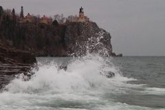
A Gale warning is currently in effect for much of Lake Superior where the highest winds are hitting along the north shore.
Footage from around Silver Bay, MN and the Split Rock Light House.
Various shots of large waves crashing and high winds over the lake.
TRT: 4:45;12
Clip 1 Wide shot of high winds ripping apart a flag and the surf crashing on the large boulders in Silver Bay, MN
Clip 2 Tight shot of the flag blowing in the wind.
Clip 3 Split Rock Light House in the back ground with large waves crashing in the foreground.
Clip 4 Wider shot of Split Rock Light House in the back ground with large waves crashing in the foreground.
Clip 5 Wide high shot of large waves and white caps over Lake Superior. In the distance you can see the shoreline along Upper Michigan.
Clip 6 Tight shot looking down on large waves on Lake Superior.
Clip 7 Very wide shot of the waves on Lake Superior
Clip 8 – 12 Large waves crash into the wall at the Marina in Silver Bay, MN
Clip 13 Low shot of large waves on Lake Superior
Clip 14 Waves crash into the rocks off shore.
Clip 15 Large waves just south of Split Rock Lighthouse crash up against Ellingson Island that protects the shoreline.
Clip 16 Large waves and the sun setting along the shoreline.
Clip 17 – 18 Large waves crash on the shoreline between Ellingson Island and the shore.
Clip 19 – 20 Big waves crash along the shoreline on Ellingson Island next to the camera.
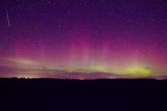
For the second time this month, the sky has lit up over central Minnesota with the Aurora Borealis or Northern Lights. This storm hit the earths magnetic field yesterday afternoon and triggered a G1 Class Geomagnetic Storm with a KP Index of 5.
This footage was shot just north of the city of Saint Cloud, MN. Video shows the Northern Lights dancing across the nights sky.
SID: Douglas Kiesling
© StormChasingVideo.com
News B-Roll footage from Nebraska of the Stanton and Wayne Tornadoes. The first Tornadoes of the day where near Stanton Nebraska which turned into the Wayne Nebraska 1 mile wedge tornado as seen tracking northeast along HWY 15 and than from 2 miles south of the town of Wayne as it was hitting the town. The remaining footage was from rural Wayne NE tornado damage from moments after tornado passed.
SID: Nick Elms
© StormChasingVideo.com
Stock footage from the historic El Reno, OK Tornado. Video starts out along Interstate 40 and as the tornado was moving towards the area.
The videographers approach the tornado near the El Reno Airport as it became rain wrapped and they found they were too close. Footage continues as they drive towards the Interstate on South Country Club Road and head east on Interstate 40.
At 13;02;09 the footage was shot along Interstate 40 looking southwest as the tornado crossed over highway 81 and toward Radio Road and Reuter where debris can be seen being thrown into the air before the camera crew continues to escape to the east to avoid being hit by the mulitvortex tornado.
Catalog ID: 05312013_JB
Total Run Time: 18;22;28
http://www.StormChasingVideo.com
Footage of the rapidly changing fall colors from Northern Minnesota around Lutsen, MN in the Sawtooth Mountain range along the north shore of Lake Superior.
Various footage of wide and very close up from on top of Moose Mountain and along the Temperance River valley.
Clip 1 Shot of the National Forest sign welcoming visitors to the Fall Color Tour in the Sawtooth Mountains.
Clip 2 Fall colors from on top of Moose Mountain
Clip 3 Pan shot on top of Moose Mountain
Clip 4 – 5 Fall colors along the Temperance River valley.
Clip 6 Driving along the Temperance River valley.
Clip 7 Traffic checking out the colors
Clip 8 – 9 Fall colors from on top of Moose Mountain
Clip 10 Tight shot with a fast pull back on top of the mountain.
Clip 11 Medium shot of lots of color
Clip 12 Tight shot of lots of color
Clip 13 – 18 Wide shot of lots of color
Clip 19 – 20 Medium shot of lots of color
Clip 21 – 25 Tight shots of colors
Clip 26 – 27 Wide shot of color and Lake Superior in the distance
Clip 28 Wide shot of colors from on top of the mountain
Clip 29 Medium shot of contrasting colors of Orange and Green showing the 50% color change.
Clip 30 – 31 Tight shots of color
Clip 32 POV driving shots under a canopy of color.
Clip 33 36 Tight shots of fall colors.
SID: Douglas Kiesling
StormChasingVideo.com
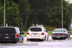
Two days of rain thanks to abundant moisture and a stalled frontal boundary have lead to widespread flooding. Rain will continue through Thursday before drier air moves in on Friday. Video package includes various shots of cars and trucks driving through flood water, LEO on scene, road underwater along Hwy 17.
SID: Brian Barnes
A Fall-ushering cold front swept through the region on Friday bringing long overdue rains to the area and knocking temperatures down to more Fall-like values for the last day of summer. Many areas received over an inch of rain on Friday, but skies cleared overnight and left behind perfect weather for many of the area festivals going on across the region. Sunny skies and temperatures in the low 70s greeted festival-goers who enjoyed good food, parades, and music.
Video package is a two-parter, covering two of the Saturday festivals in southern IL. TRT is 4:58, see description below for festival locations and information.
PART 1 – Shrimp Festival in Golconda, IL (0:00-2:57)
The 13th Annual Shrimp Festival occurs every year in Golconda along the Ohio River. It began in 2001 to help promote Southern Illinois Prawn Growers and has been growing every year since. Along with the fantastic foods, goers can take a buggy ride or fly aboard a Black Diamond Aviation Helicopter. This was also the second year that a Corn Hole Contest was run.
Scene 1: Wide shot of festival.
Scene 2: Shot of festival tents in front of downtown building.
Scene 3: Shot of stage with Cotton Patch Express playing.
Scene 4: People standing in line for shrimp foods.
Scene 5-9: Various shots of people eating food.
Scene 10: Panned shot of people standing in line for food.
Scene 11: Festival goer holding bowl of gumbo.
Scene 12-16: Various shots of shrimp and other festival food.
Scene 17-18: Shots of the second annual Corn Hole contest.
Scene 19: Shot of bean bag getting into the corn hole.
Scene 20: Long shot of the helicopter flying over the Ohio River and landing.
PART 2 – Wonder Water Reunion in Creal Springs, IL (2:58-4:58)
The Wonder Water Reunion has been held for more than six decades in Creal Springs, Illinois. The Wonder Water name comes from the bathhouses that were once in Creal Springs. The wells were believed to be therapeutic, curing ailments from stomach and back problems to arthritis. The parade is the main event on Saturday, the festival’s final day, which runs through the center of town and gives kids a chance to feast on pre-Halloween candy.
Scene 21: Shot of main street in town with parade starting.
Scene 22: One of the festival queens tossing candy to the kiddies.
Scene 23-24: Shots the local favorites, Williamson County Motor Patrol.
Scene 25: The K-2 Crab Orchard Shakers waving from the top of a fire truck.
Scene 26: Another festival Queen tossing candy to kids.
Scene 27: Panning out from the crowd as kids collect candy.
Scene 28: Shot of a kid collecting a piece of candy and putting it in a bag.
Scene 29: Kids collect candy and add to their big piles.
Scene 30: Close up of candy piles.
Scene 31: Shot of horse riders in the parade.
Scene 32: Shot of parade with onlookers.
Scene 33: Two ladies waving as they drive away in the parade.
SID: Tony Laubach
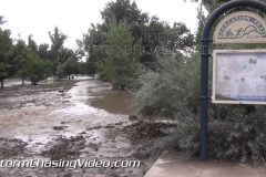
opening scenes of video start at the mouth of the big Thompson canyon where highway 34 once was. And also shows the control gate where the workers were cranking open valves to divert water.
next scene is from Sylvandale Guest ranch and shows power pole down and bridge gone.
proceeding on the next scene shows a national guard road block near highway 34 and glade road with a blackhawk flying overhead as well.
we then transition back into the city limits of Loveland and go to the fairgrounds park and softball fields for some general shots of the river out of its banks, and Burlington northern railway beginning repairs on a major rail line that serves the front range and into Wyoming.
SID: Justin King
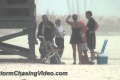
Beach goers are determined to get some beach time in this Labor Day weekend even if they have to battle the coastal thunderstorms. HD video of beach goers battling rain on a holiday weekend in FL. run time 4:55. Money shot is at time 1:16.
Shot list:
1) Cars driving into the beach parking lot at Siesta Key Beach despite the forecast of coastal morning storms.
2) People setup on beach along the shore with an approaching storm.
3,4,5) Three shots of approaching black storm clouds over beach and water with people watching.
6) Some people making a exodus off the beach as the rain hits.
7) A family of three pops up the umbrellas as a wind picks up a beach umbrella and sends it flying down the beach where it almost hits a woman.
8) MONEY SHOT. Woman trying to hide behind a beach umbrella gets pummeled by wind driver rain. Hat blows off. Man rushes in to help her.
9) Family hides under the blue beach tent trying to hang on to it to keep the wind from blowing it away.
10) Another family lowered their beige tent trying to keep the wind from taking it.
11) Woman with umbrella and baby stroller and husband and another child while thunder rolls.
12) Young girl and her mother under beach umbrella in wind/rain while thunder rolls.
13) Another shot of people under the blue beach tent in wind/rain.
14) Couple hiding under their limp beach umbrella.
15) People under a black beach tent in rain.
16) Wide shot of a rain soaked beach with people and their beach canopies, umbrellas, and tents.
17) Couple under an orange beach umbrella with a rain flooded beach behind.
18) Wide shot of rain flooded Siesta Key beach with condos behind.
19) Family going out to beach walks through huge rain puddle with their beach gear.
20) People with beach chairs walk through huge rain puddle on beach.
21) Close shot of feet walking through puddle.
22) Shot of people walking beach with flood puddle in foreground and gulf and storm clouds behind.
23,24) Rain wet beach parking lot with cars driving looking for a open spot. Rain won’t stop FL people from hitting the beach on a holiday weekend.
25,26) Two shots of flooded picnic area at north end of beach.
SID: Brian Dombrowski
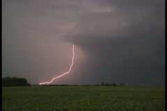
Severe storms brought heavy rain, high winds and vivid lightning to west central Minnesota on Saturday afternoon.
Footage shows the storms that hit the Pope County, MN area which is about 100 west of the Twin Cities metro area.
Clip 01 High winds blow large construction debris across the road in front of the camera.
Clip 02 – 03 POV shots of high winds gusting over 50 miles per hour.
Clip 04 Storm front moving from the west near the town of Starbuck, MN
Clip 05 – 11 B-Roll of lightning and the storm front moving towards the camera near Starbuck, MN
Clip 12 Line of storms over taking area.
Clip 13 Lowering behind the leading edge.
Clip 14 – 15 Driving in high winds with lowering clouds
Clip 16 POV shot of very close lightning
Clip 17 Lightning after dark.
SID: Douglas Kiesling
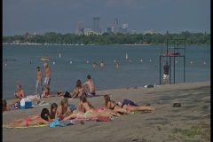
Who let the dogs out because after an unusually cool and sometimes cold summer in Minneapolis, MN, the Dog days of summer have finally arrived this week.
Footage shot around the south beach of Lake Calhoun in Minneapolis, MN
TRT 3:41
Clip 1 People on a paddle boards on Lake
Clip 2 People at South Beach on lake Calhoun in Minneapolis.
Clip 3 People walking their dog (dog days)
Clip 4 Two women running with their dog and run right up to the camera next to the fountain with a dish with water for the dogs.
Clip 5 Low shot of a dog walking by the camera.
Clip 6 Medium shot of people in the water at the beach with the skyline in the background
Clip 7 Medium shot of two women standing in the lake.
Clip 8 – 9 Life guards looking out over the water.
Clip 10 Someone running
Clip 11 People walking and running past the camera
Clip 12 A couple walking past the camera
Clip 13 A man helping a young girl get a drink from the well fountain
Clip 14 Group of people biking on the bike path
Clip 15 People out on the diving platform on the lake.
Clip 16 – 17 People playing volleyball
SID: Douglas Kiesling
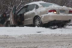
Severe-warned storms swept across southern IL early Monday afternoon bringing heavy rain and wind. Storms that moved across Union County lead to nearly an inch of rain falling in places within 45 minutes and lead to a hydroplaning accident along I-57.
Video package includes scenes of vehicle in median in addition to the car being pulled out by a tow truck driver who just happened upon the scene. The Mississippi man was southbound back to MS and spun 1-and-a-half times when heavy rains caused him to lose control of the truck. He came to rest facing the southbound lanes and was not injured, just shaken up.
While examining his truck, a tow driver pulled on to the scene and latched up his tow truck to the vehicle and pulled him out. Afterwards, the Miss. man was insistent on trying to give the truck driver something for helping him, but the tow truck driver was equally as insistent on not taking payment and was just happy he could help the man.
Examination of the truck showed the exhaust pipe was bent around under the vehicle, but was still drivable. Upon recommendation from the two truck driver, the man took his truck to the Anna exit only a couple miles down to have a nearby body shop cut off the bent pipe so he could continue his trip home to Mississippi.
Shot List
Scene 1: Panned shot of the tire tracks in the median to the stranded truck.
Scene 2: Shot of the man and his truck as the tow truck arrives on scene.
Scene 3-4: Wide and close shots of the tow truck driver attaching a chain to the pickup truck.
Scene 5: Long shot of the pickup’s first attempt to straighten out the pickup truck in the median.
Scene 6: Man gets back in his awkwardly positioned truck in the median.
Scene 7: Shot as tow truck pulls the pickup to the inside shoulder of I-57.
Scene 8: Shot of the bent exhaust under the pickup truck.
Scene 9: Shot of man and pickup truck in the median before tow truck arrived.
Scene 10: Wide shot after being pulled out when Illinois State Patrol arrived.
Scene 11-13: Shots of storm clouds on the approaching storm.
Scene 14-15: POV drive shots during the heavy rains.
Scene 16-17: Wide and close shot of a vehicle with emergency flashes pulled off the road during the heavy rains.
Scene 18: Truck drives through flooded road in the town of Anna.
Scene 19: A vehicle pulls out of an intersection through some minor ponding.
Scene 20: A couple vehicles drive through a puddle of water in Anna.
Scene 21: Static shot of flooded side road.
SID: Tony Laubach
To license this footage, contact http://www.StormChasingVideo.com
Sharknado 2 – When real storm chasers take on real sharks. And a freak supercell hit’s Oklahoma, nature’s deadliest killer weather teams up with the oceans monsters as thousands of sharks terrorize the oblivious public who ignored the tornado watch…
After hearing about the first one and now a The Second One, we just had to play with the footage in our stock footage archives.
Footage from StormChasingVideo.com from Doug Kiesling, Brandon Sullivan and Brian Dombrowski.
Severe storms hit central Minnesota this evening as tornado warned and severe warned storms moved along Interstate 94 from western Minnesota to the Twin Cities metro area.
Footage shows the storms from just west of Glenwood, MN where the storm became tornado warned to near New London, MN where the storm became outflow dominant and a major hail producer.
Clip 1 Driving west on Highway 28 towards a tornado warned storm.
Clip 2 – 3 Looking west towards the tornado warned storm with a rain shaft on the right and ragged disorganized lowering on the left.
Clip 4 Flanking the storm on the south side as the leading edge overtakes the vehicle.
Clip 5 Driving in hail
Clip 6 Driving in larger hail that hits the car right in front or the camera. Good audio.
Clip 7 Zoomed in shot of the hail on the ground while driving.
Clip 8 POV shot following another car in the hail storm.
Clip 9 Driving in the hail with lots of tree branches down.
Clip 10 Driving into New London with hail failing.
Clip 11 Lots of large hail falling and making a dash to get under a gas station canopy.
Clip 12 Looking out towards the street while parked as the hail falls.
Clip 13 – 14 Hail falling and the camera while shooting hail hitting parked cars.
Clip 15 Hail falling with a pan to the left to show hail hitting the car next to the camera.
Clip 16 Hail falling and hitting the ground.
Clip 17 Hail falling and hitting a roof with a Dish Network antenna on it.
Clip 18 The second wave of the storms passing by which looked good but were not severe.
Clip 19 Behind the storm, Rainbow.
Clip 20 – 21 Mammatus Clouds at sunset.
SID: Douglas Kiesling