The video posted to our Youtube Channel is NOT sponsored and Youtube Advertising deems storm chasing and natural disaster videos as not advertiser friendly. If you would like to support us, click on the link below to visit our merchandise store.
http://www.stormchasingvideo.com/scv-merch-store/
High winds from a strong low pressure system and the almost ice covered lake caused what can only be called a Mini Glacier event on the south side of Mille Lacs Lake in the town of Onamia, MN
With winds gusting over 35 miles per hour this morning, part of the massive ice sheet covering the lake started to move and when it moved, it moved south and came on shore like a glacier into the Izatys Resort area.
Footage shot on the south side of Mille Lacs Lake (Pronounced Mil-Lac-s) and is French for “One Thousand Lakes” because of it size. The area is located about 100 miles north of Minneapolis, MN. Mille Lacs is the second largest lake in the state of Minnesota. It has an area of 132,516 acres or 207.06mi² which was still over 90 percent covered in about 12 to 15 inches of ice this morning.
By the time it was over, the depth of the mini glacier was one to three feet at the edge near the town houses to over 25 feet at the lake shore. Maintenance personal for Izatys Resort said that clean up could take all summer due to the ice moving massive lake side and under water boulders onto the shore.
Clip 1 Pan up shot of large ice boulders on shore to the still ice covered lake.
Clip 2 Pull back shot of the ground pushed upwards where the grass is now deformed from the force of the ice being pushed on shore.
Clip 3 A dog playing on the shore line on the ice blocks that are the size of a small car.
Clip 4 People standing on massive blocks of ice with a huge glacial ice mass behind them.
Clip 5 – 6 Tree’s stripped of the bark from the force of the ice moving on shore.
Clip 7 Massive ice piled up against a home along the lake shore and the ice crashed through the from of the porch.
Clip 8 Bulldozer parked after pushing back some of the ice from the homes.
Clip 9 Pull back shot of the ice after it crashed through this home.
Clip 10 View from the side of after Ice smashed in the front of the porch on this town home.
Clip 11 Large ice boulders piled up against the side of the town homes.
Clip 12 Ice piled up on the shore that is at least 15 feet high
Clip 13 Pullback shot of massive amounts of ice piled up on the shoreline where it was over 20 feet in the air.
Clip 14 Ice stacked up on the shore line to 15-20 feet high.
Clip 15 Ice covered the yard after crews patched up the hole in the side of a town home that was damaged by the ice flow.
Clip 16 Pan left shot of massive ice boulders up against the town homes.
Clip 17 Pan left shot of the huge piles of ice stacked up along the shoreline, shot from the shifting ice on the water.
Clip 18 Push in shot of the home that was damaged and a metal picnic table that was cast aside like a toy by the ice.
Clip 19 – 20 What was left of the picnic table after the ice flow.
Clip 21 Ice piled up three feet high against a home and smashed their grill.
Clip 22 Someone walking on the massive ice boulders.
Clip 23 People walking along the massive ice chunks on the shoreline
Clip 24 Trees covered by the ice with lots of ice boulders
Clip 25 Some crazy fool thought it was a good day to go wind surfing on the ice.
Clip 26 Pull back shot of a massive ice chunk that is at least three feet by three feet by one foot thick and it pulls back to show the ice piled up against the homes.
Clip 27 Ice piled up against a home with the patio furniture still in place but the drain was partial ripped off the home.
Clip 28 Massive ice boulders next to actual boulders.
Clip 29 A field of ice boulders
Clip 30 – 32 A mountain of ice along the shoreline
Clip 33 What was left of trees after being smashed into by the ice.
Clip 34 Pull back shot of the ice where it was over 20 feet high.
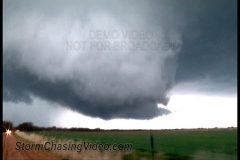
An outbreak of severe weather caps off a busy week across southern and central Texas. Several long-track supercells forming in Mexico moved into the state and dropped very large hail, high winds, and caused some minor flooding.
Video package shot in and around the town of Castroville, Texas in Medina County west of San Antonio.
TRT – 4:34
Scene 1: Wide shot of impressive storm structure and wall cloud west of Castroville.
Scene 2: Wide shot of storm with lightning strike.
Scene 3: Shot of storm clouds in town with vivid lightning strike.
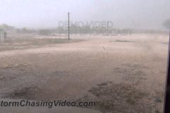
Scene 4-6: Dust blowing and creating low visibilities along US-90 west of Catroville.
Scene 7: Chaser filming oncoming dust and closing window as dust overtakes vehicle and makes trees in foreground disappear completely.
Scene 8: POV driving through blowing dust.
Scene 9: Storm arrives in Castroville with high winds and rain, shot of truck at gas station in storm.
Scene 10: Shot of car as 1.25″ hail pounds into parking lot.
Scene 11-13: Shots of 1.25″ hail falling hard in storm.
Scene 14: Shot of parking lot after majority of hail stops falling showing stones.
Scene 15: Cars driving through street flooding with hail drift in foreground as rain falls.
Scene 16: Cars driving through street flooding with hail river flowing.
Scene 17: Cars driving through street flooding with hail drift in foreground as rain falls.
Scene 18: Cars driving through street flooding.
Scene 19: Shot of half-foot deep hail drifts.
Scene 20: Post storm shot of a neighborhood street turned into a river as truck drives through.
Scene 21: Slow oncoming car driving through street river.
Scene 22: Slow car driving away from camera through street flood.
Scene 23: Shot of water flowing fast across intersection.
Scene 24-25: Tight and wide shots of street turned into a river.
Scene 26-27: Shot of neighborhood roads covered in shredded leaves from the hail.
Scene 28: Shot of parking lot covered in hail post-storm.
To license this footage, visit http://www.StormChasingVideo.com
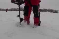
A short video of all the volunteers helping out to drill the holes for the Boy Scouts Of America and Simply Outdoor Experiences on Fishing Derby on Saturday, Feb 9, 2013.
Severe storms ripped across central Texas on Thursday with massive hail causing damage to numerous vehicles. Many reports of hail up to and exceeding baseball sized were reported with supercells that developed around and south of Abilene.
Video shot in and around the town of Ballinger, Texas in Runnels County along US-83.
TRT – 3:56
Scene 1: Establishing wide shot of the supercell moments before the hail began on the highway.
Scene 2: Shot of ragged wall cloud.
Scene 3: POV with excellent sound of vehicle being hit with baseball sized hail. Even a crack appears on camera when a stone strikes the windshield.
Scene 4-5: POV of hail on US-83.
Scene 6: Shot of pickup truck in high winds and heavy hail.
Scene 7: Insane amounts of hail coming down furiously during storm.
Scene 8: Pan shot of tree to a pickup truck during hailstorm.
Scene 9: Heavy hail falling and covering the ground.
Scene 10: Hail falling near farm structure.
Scene 11-13: Various shots of very heavy hail falling looking like a blizzard.
Scene 14: Wind and hail
Scene 15: Panning shot of hail up to baseball size covering the ground.
Scene 16: Large hail in hand with hail on ground below.
Scene 17: Shot of a stone nearly 3-inches long being compared to a shattered windshield.
Scene 18-19: Shot of hailstones to busted windshields.
Scene 20: Shot of large stone compared to racquetball.
Scene 21: Shots of large stones with ruler, lime, and racquetball.
Scene 22: Shot of racquetball and lime with multiple large stones.
Scene 23: Shot of a spikey stone measured up to 2.75″ in diameter.
Scene 24-26: Shot of a pickup truck that slid off the highway during the storm. Last shot includes panning of hood with leaf debris.
An outbreak of severe weather impacts Kansas and Oklahoma with large hail and beautiful storms! This is the first of a three day stint of severe weather across the central and southern plains.
Video shot around Protection, KS in Comanche County.
Scene 1: Wide shot of LP supercell
Scene 2: Wide shot of LP supercell
Scene 3-4: Panning shots of ominous clouds
Scene 5: Horizontal cone funnel
Scene 6: POV in high contrast hail
Scene 7: High contrast hail up to golfballs.
Scene 8-9: Shots of road with large hail falling and hitting.
Scene 10: Pan shot from storm to street with hail.
Scene 11: Wide shot of high contrast hail and rainbow.
Scene 12-15: Golfball hailstones compared and measured.
Scene 16: Hail in hand.
Domestic Terror hits the heartland.
Residents and business along a a section of 29th Avenue and 1st Street North were evacuated and the street was blocked off all afternoon after a IED was found by local resident Corey Gaulrapp.
Gaulrapp says he discovered the item, while walking along the street which he said he believes was a pipe bomb. He picked up the object before realizing what it was and then contacted police to tell him what he found.
The IED was located along the street outside of the Saint Cloud Hospital, Home Care offices.
The Crow Wing County bomb squad was called in to destroy the suspicious object Saturday afternoon about 4:45 p.m. and police say it did contain explosives.
Law enforcement is still investigating.
Clip 01 Police setting up the yellow tape
Clip 02 Squad car blocking the road
Clip 03 Corey Gaulrapp who found the IED talking about what he was doing and pan back to the location of the IED on the side of the road.
Clip 04 Corey Gaulrapp interview.
Clip 05 Crow Wing County Bomb Squad showing up.
Clip 06 Police SUV Blocking the road
Clip 07 Bomb squad truck
Clip 08 Ambulance setting up
Clip 09 Fire crews waiting on standby
Clip 10 – 11 Bomb Squad Tech walking out to the IED
Clip 12 Bomb squad blowing up the IED
Clip 13 Bomb Tech taking off the gear.
Clip 14 – 15 Law enforcement investigating the scene after the IED was neutralized.
To license this video, contact StormChasingVideo.com
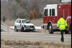
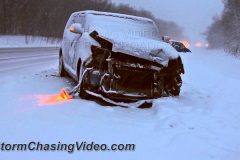
The Minnesota State Patrol and MNDOT shut down traffic along Interstate 94 this afternoon. The accident happened in the construction zone where MNDot has Interstate 94 reduced to one lane in each direction from County Road 75 to Clearwater, MN. Traffic was diverted onto County Road 75.
In the video you can see the Semi Truck, Yukon XL SUV and the silver vehicle which looks like a Minivan or crossover Mini-Suv, were involved in a three vehicle crash about a mile south of the Opportunity Drive exit on Interstate 94.
The condition of the driver of the silver vehicle that was in the center ditch are unknown at this time and were already taken away by EMS workers at the time of this video.
© StormChasingVideo.com
A powerful winter storm system is creating a heavy wet nightmare for drivers along Interstate 35 in southern Minnesota this evening.
The winter storm warning remains in effect until 10:00 a.m. Thursday morning.
Footage shot on Interstate 35 around the Owatonna, MN area where several inches of heavy wet snow have already fallen and accumulated on the grassy surfaces. The roadways have also cooled off to where they are also becoming covered in snow when it should be the middle of spring.
TRT: 4:44;19
Clip 01 Shot of main street Owatonna at sunset with the power plant sign and traffic.
Clip 02 Pull back shot of a tight shot of buds on a tree trying to bloom covered in ice and snow then pulls back to show the whole field in the back ground covered in ice and snow.
Clip 03 Tree buds covered in ice and snow
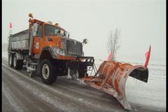
Clip 04 Passing tracking shot of a snow plow on Interstate 35
Clip 05 Long pov shot of a snow plow in front of the camera.
Clip 06 Passing shot of a snow plow
Clip 07 Oncoming passing shot of a snow plow.
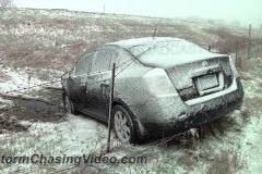
Clip 08 Pan shot to the right of tracks in the snow and then the car that slammed into the barbed wire fence along Interstate 35.
Clip 09 Tight shot of the barbed wire on the car then pull back to show the whole car. The barbed wire is holding the car like winter has its grasp on midwest.
Clip 10 Alternate shot of the car with the tracks in the snow where it crashed.
Clip 11 Dash cam after the state patrol showed up. Driver was ok.
Clip 13 Tow truck pulling a car out of the ditch.
Clip 14 State trooper in the snow blocking traffic
Clip 15 – 16 Heavy snow with trees
Clip 17 Snow over an open area with tree’s in the background covered in snow.
Clip 18 Statue covered in snow.
Clip 19 POV Drive by shot of a car in the ditch with State Patrol and crews on the scene.
Clip 20 POV Drive by shot of a car in the ditch with crews on the scene.
Clip 21 POV Drive by with a white pickup truck in the ditch.
Clip 22 White Buick in the ditch.
Clip 23 POV Drive by shot of a car in the ditch with crews on the scene.
Clip 24 POV Driving shot in heavy snow.
To license this footage for broadcast, contact http://www.StormChasingVideo.com
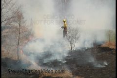
Interstate 94 was shut down this afternoon in Saint Cloud, MN due to a wild fire that quickly got out of control before the Saint Cloud and Saint Augusta fire departments arrived on the scene.
Footage was shot from the county road 136 bridge or Oak Grove Road SW, over Interstate 94 as the high winds and dry grass made the fire expand quickly along the east bound lanes of Interstate 94 towards the county road 75 exit ramp.
Clip 01 Close up shot of the fire burning the grass along Interstate 94.
Clip 02 Fire water tanker truck driving along the side of I94 in the thick smoke.
Clip 03 Resident spraying water on his yard to prevent the fire from coming towards his home.
Clip 04 Wide shot of the person spraying water on the yard as the fire line is moving towards them.
Clip 05 Interstate 94 traffic backed up in the heavy thick smoke and high winds.
Clip 06 Fire crews on the scene in the yard to fight the fire.
Clip 07 Close up shots of the fire burning
Clip 08 Fire crews showing up on the scene.
Clip 09 Wide shot of the fire burning and jumps over to crews fighting the fire on a medium shot.
Clip 10 Fire Crews showing up on the scene
Clip 11 Fire Crews fighting the fire.
Clip 12 Fire Crews fighting the fire.
Clip 13 Wider shot of fire fighter in the fire.
Clip 14 More crews fighting the fire.
Clip 15 Fire fighter hosing down the area
Clip 16 Sheriffs deputy and Saint Cloud Fire Department truck blocking the traffic on Interstate 94 and shutting it down to all traffic going east bound.
Clip 17 Fire crews working to put the fire out.
Clip 18 State Patrol squad car showing up on the scene.
Clip 19 Saint Cloud Fire Crews and State Patrol blocking Interstate 94.
Clip 20 Pull back shot of the traffic backed up towards Highway 15 on the east bound lanes of Interstate 94 the shows the traffic stuck on the interstate and ends at the shot of the Engine 2 Fire Truck and State Trooper.
Clip 21 Tight shot of Saint Cloud fire truck door.
Clip 22 State trooper and Saint Cloud Police on the scene.
Clip 23 Tight shot of the front of the State Trooper squad car.
To license this footage, visit http://www.StormChasingVideo.com
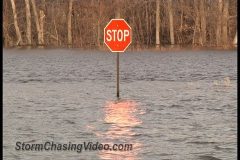
While Fargo, ND prepares for the Red River of the North crest, the river’s that feed into the Red River are now cresting just to the south of the Fargo / Moorhead, metro area.
Clip 1 Wide shot of large area flooded out.
Clip 2 Road Closed sign with flooding behind the signs.
Clip 3 Stop sign with water half way up the sign pole.
Clip 4 Road signs in the water.
Clip 5 Shot of all the flooding and signs in the water.
Clip 6 What was a farm field is now a lake with Swans swimming in the high water.
Clip 7 Rushing water cutting through a farm field. Pull back shot.
Clip 8 High water pull back shot from the bridge to where the road should be.
Clip 9 Snow pack still on the ground in areas.
Clip 10 Running water in the ditches that are flowing to the Buffalo river.
Clip 11 Buffalo River with major flooding just south of the town of Sabin, MN.
Clip 12 Flooding around a farm. The farm has a dike around it to protect it from the high waters.
Clip 13 Road signs in the flooding.
Clip 14 Wide shot of the flooding and road signs with the farm on the left.
Clip 15 Snow pack filling up the ditches along the road near the Buffalo River.
Clip 16 More snow pack covering areas on the north sides of the farm fields. Pan shot from Right to Left.
Clip 17 Medium shot of the Buffalo River washing out a roadway for about a quarter mile.
Clip 18 House surrounded by water but not flooded out.
Clip 19 Buffalo River sign at the bridge just south of the town of Sabin, MN with the massive flooding in the background.
Clip 20 Water flowing under the bridge and it is only a couple feet from touching the beams on the bridge deck. Pan shot to the right to show the large area of flooding.
Clip 21 A rail road bridge with water almost up to the deck.
Clip 22 Snow pack and flooding.
Clip 23 Pan shot showing the snow pack along the side of the Buffalo River and the camera pans right to show how far the river has gone over its banks for almost a quarter mile to the west side of the river.
Clip 24 In the setting sun light, the flooding covers most of the ground to where the house in about a quarter mile away from the camera.
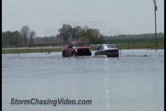
Major flooding continues along the Mississippi River and is causing backups in creeks and smaller rivers that feed into the Mississippi. Flooding is resulting from these backups several miles from the river.
Video shot in and around the small town of Dutchtown, Missouri just outside of Cape Girardeau. Includes shots of two vehicles precariously navigating a flooded rural road that feeds into Dutchtown and being very fortunate to make it to the other side. Other shots include sandbags barricading homes in town as well as shots of flooded fields.
TRT – 4:58
Scene 1: Establishing shot looking down Missouri Highway 74 with flooded field on the left and city limit sign on right.
Scene 2: Shot of MO-74 with flooding right next to road.
Scene 3: Vehicle entering flooded road along Missouri Highway A juts west of Dutchtown.
Scene 4: Wide shot of vehicle in waters along flooded road.
Scene 5: Tight shot of vehicle in flood waters.
Scene 6: Wide shot of oncoming truck and other vehicle in the middle of the flood waters.
Scene 7: Long zoomed shot of oncoming truck in the flood waters, driving til exiting waters passed camera.
Scene 8: Zoomed shot of first vehicle exiting flood waters on other side of flood.
Scene 9: Shot looking over flooded road at red pickup truck with people.
Scene 10: Shot of empty flooded road.
Scene 11: Signs warning of water on road with flood over road in background.
Scene 12: “Water Over Road” sign with flooded road in background.
Scene 13: Shot of water over road.
Scene 14: Shot of home with sandbags barricading the residence in Dutchtown.
Scene 15-16: Wide shot of house with sandbags in front in Dutchtown.
Scene 17: Shot of sandbag wall near Dutchtown residence.
Scene 18: Close up of sandbag pile.
Scene 19-20: Shot of sandbags along MO-74 in Dutchtown.
Scene 21: Looking over sandbag barricade of farmstead surrounded by flood waters.
Scene 22: Zoomed shot of farmstead surrounded by flood waters.
Scene 23: Flooded field near Dutchtown.
Scene 24: Zoomed shot of sign in flood waters.
Scene 25: Looking down a flooded road to an old farmstead.
Scene 26: Zoomed shot of farmstead surrounded by flooding.
Scene 27: Flooded field with farmstead in background.
Scene 28-29: Flooded fields with many acres under water.
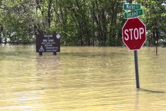
Major flooding continues along the Mississippi River as the high water levels have moved south creating issues across the southern parts of Illinois and Missouri. Water levels are near major flood stage in Cape Girardeau with a crest of 42′ expected by Friday morning before slowly receding through next week.
TRT – 4:17
Scene 1: Establishing shot of the bridge over the flooded Mississippi leading into Cape Girardeau from Illinois.
Scene 2: Tight shot of flow on Mississippi at base of bridge.
Scene 3: Shot of road closed barricade with man and dog in background.
Scene 4-9: Various shots of barricades blocking various streets along the river in Cape Girardeau.
Scene 10-11: Shot of half submerged stop sign.
Scene 12-13: Shot of flooded railroad crossing.
Scene 14: Shot of a submerged vehicle.
Scene 15-17: Shots of various road signs in flood waters.
Scene 18: Shot of flooded shelter.
Scene 19-20: Shots of truck sign and flooded bridge.
Scene 21: Shot of fire hydrant with flooded out building in background.
Scene 22: Tight shot of fire hydrant.
Scene 23: Tight shot of flooded building.
Scene 24: Shot of mailbox in flood water.
Scene 25: Shot of two barricades blocking flooded road.
Scene 26-28: Shots of fire hydrant along flooded road.
Scene 29: Flood waters high on a fence.
Scene 30: Woman and her dog walk passed camera with flood water/barricade in background.
To license this footage, visit http://www.StormChasingVideo.com
Everyone in the greater Twin Cities metro area of Minneapolis and Saint Paul metro area of Minnesota, and the rest of Minnesota is hoping that this is the final winter storm and final round of snow for the season.
A powerful winter storm dumped another half of a foot of heavy wet snow in the south metro area of Dakota County.
Even the crews at the Minneapolis International Airport had to go back to winter mode to de-ice airplanes this evening.
And in the later part of the video, April Snow Showers Bring Minnesota Snow Plowers… and cars in the ditches.
Clip 1 Spoon Bridge at the sculpture garden in downtown Minneapolis. They snow was so heavy that you could not see the skyline in the background.
Clip 2-4 Footage of Robins in the snow looking for food.
Clip 05 A treeline and the heavy snow falling.
Clip 06 Aircraft taxiing in the snow at the Minneapolis & Saint Paul International Airport.
Clip 07 Aircraft landing
Clip 08 – 13 Various shot of aircraft de-icing.
Clip 14 Snow falling with a light highlighting the snow and aircraft in the background.
Clip 15 One of the worlds largest aircraft, an Antonov Cargo plane landing in the heavy snow.
*************************************************
The following clips were shot after dark in Dakota County showing the poor driving conditions in the heavy snow.
Clip 16 Flag blowing in the wind and snow
Clip 17 – 18 SUV sliding in the snow
Clip 19 Car spinning the front tires in the snow trying to go forward.
Clip 20 – 21 Heavy snow covering tree branches
Clip 22 Mini van spinning its tires trying to drive up a hill
Clip 23 – 24 Burnsville, MN city banner signs. Once side is coated the while the other side you can kind of make out what it says.
Clip 25 POV dash camera showing a sign warning of a crash ahead
Clip 26 Drive by shot of a car in the ditch on Interstate 35E
Clip 27 Drive by shot of a car in the center cables on Interstate 35E with police on the scene.
Clip 28 Minivan in the ditch on Interstate 35E
Clip 29 State Patrol on the scene of a crash on Interstate 35E with the car in the center cables
Clip 30 SUV crashed on the exit ramp of 35E and county road 50
Clip 31 – 37 Various snow plow footage.
Record flooding is occurring along the Kaskaskia River at Vandalia in south-central Illinois. As of 4pm CDT Friday, the river was at 27.89′, the second highest recorded depth (only behind the May-2002 record of 28.27′). It is forecast to crest around 29′ Friday evening which would be a new all-time record for this location. The river is expected to slowly fall to below flood stage by Wednesday.
As a result of the flooding, levees near the town were being overtaken with water and several low-lying areas in town were inundated with as much as 6′ of water due to many creeks feeding the Kaskaskia getting backed up due to the high levels of water.
Engineers were discussing whether to release one of the levees up stream to try and lower the river levels. A decision had not been reached as of this upload (5:15pm CDT).
TRT – 6:10
Part 1 (0:00-0:34) Establishing Shots
Scene 1 – Shot of Kaskaskia River sign with flooded river in background.
Scene 2 – Shot of the Left Bank Levee spilling over to a nearby field with the US-51 sign in the foreground.
Scene 3 – Shot of the gage house at the river.
Part 2 (0:34-3:14) Town of Vandalia
Scene 4 – Wide shot of flooding across Jefferson & 4th.
Scene 5 – Shot of barricade with flooded house in the background.
Scene 6 – Close up of residents on the porch of a flooded home.
Scene 7 – Woman wading through flood waters in front of her home.
Scene 8 – Another house in flood waters.
Scene 9 – Front of house in flood waters.
Scene 10, 11 – Shot of a local gym with water part way up the front doors.
Scene 12 – Front of building with have submerged pop machine.
Scene 13 – Shot of building in flood waters with submerged vehicle next to it.
Scene 14 – Close up of vehicle with water up to windows.
Scene 15 – Shot of a pickup, another car, and a trailer partially submerged in water.
Scene 16 – Utility truck backing away from closed road and flood.
Scene 17 – Pickup truck turning away from closed flooded road.
Scene 18 – Three residents stand at a barricade along Jefferson St.
Scene 19 – Shot of a barricade with flood waters up to a stop sign.
Scene 20 – Shot of the 4th & Jefferson sign in flood waters.
Scene 21 – Tight shot of stop sign.
Part 3 (3:14-5:04) Overtaken Levees
Scene 22 – Wide shot of road with Vandalia Levee in background at a railroad crossing.
Scene 23 – Shot of R/R crossing sign with overtaken Vandalia Levee in background.
Scene 24 – Tight shot of water flowing rapidly over Left Bank Levee.
Scene 25 – Wide shot of water spilling over Left Bank Levee.
Scene 26 – Very wide shot of flooded field with overflowing Left Bank Levee in the background.
Scene 27, 28 – More tight shots of water flowing over the levees.
Scene 29 – Wide shot of Left Bank Levee overflow.
Scene 30 – Shot looking down on Left Bank Levee with water flow over the top.
Scene 31 – Tight shot of levee overflow.
Scene 32, 33, 34 – An inundated county road near the Left Bank Levee.
Part 4 (5:04-6:10) USGS Surveyer
Scene 35 – Shot of USGS van at the river.
Scene 36 – Tight shot of USGS van.
Scene 37 – Extended sequence of surveyor lowering flow instrumentation into the river from the bridge.
Scene 38 – Tight shot of river flow instrumentation in the river.
Scene 39 – Tight shot of surveyor with laptop releasing the rope along the bridge.
Scene 40 – Wide shot of surveyor on the bridge with instrumentation in the water.
To license this footage for broadcast, contact http://www.StormChasingVideo.com
Another powerful winter storm system is hitting central Minnesota hard again with more heavy snow and sleet. A foot of snow is has fallen over the Stearns County, MN area around the city of Saint Cloud, Minnesota.
B-Roll footage shows the horrible driving conditions due to the heavy snow. The snow fall rates were over an inch and a half an hour at times.
Any vehicle that crashed on Interstate 94 and was not blocking the roadway was actually left on the side of the road due to low visibility from the heavy snow making it too dangerous for tow truck crews to remove the vehicles until after the storm.
Total Run Time 4:07
Clip 01 – 03 Plow trucks plowing the on ramp on Interstate 94 at the Tornado Sirens fills audio track. This is winter awareness week and today was the day to test the sirens for tornado warnings.
Clip 04 Passing shot of a snow plow from the side camera.
Clip 05 – 07 POV shots of snow plows
Clip 08 Drive by shot of two vehicles crashed on the side of Interstate 94
Clip 09 What is left of an SUV that was left on the side of the interstate after it crashed.
Clip 10 Vehicle that slide off the interstate and stuck in the ditch.
Clip 11 POV driving in very heavy snow
Clip 12 Drive by shot of a tow truck trying to pull out a minivan stuck in the ditch on highway 75
Clip 13 Drive by shot of a car in the center ditch
Clip 14 SUV stuck in the center ditch of interstate 94
Clip 15 A Pickup truck is stuck in the deep snow in the center of Interstate 94 fails to get out and just spins all of the tires.
Clip 16 POV Driving in heavy snow
Clip 17 – 18 B-Roll of people making a large snowman in Saint Cloud
Clip 19 Heavy snow falls on the steps outside of church at sunset in downtown Saint Cloud
Clip 20 Stop sign covered with 6 inches of heavy snow
Clip 21 Flags blowing in the high winds and heavy snow
Clip 22 The stop lights on 2nd Street and the sign for 2nd Street are covered with heavy snow.
Clip 23 And, a shot from the back yard, Very heavy wet snow covers a pine tree making it look like it is the middle of December, not the third week of the Major League Baseball season…
Brand new footage in from Juston Drake and Simon Brewer of the tornado warned storms, supercells, wall clouds, hail, and downed power lines from storms near Frederick, Lawton, and Davidson.
To license this footage for broadcast, contact http://www.StormChasingVideo.com
An outbreak of severe weather pounded Oklahoma on Wednesday with tornadoes, very large hail, winds, and rain. Many supercells forming across southwest Oklahoma trained over the same areas, with storms moving up along I-44 from Lawton and multiple rounds of storms hammering the region.
Video package shot in and around Lawton and details how close it came to being hit by a tornado as well as missile-like hail and some tree damage.
TRT – 3:05
Scene 1 – Ragged clouds with Lawton water town.
Scene 2 – Shot of a very ominous clouds over Lawton.
Scene 3 – Rotating wall cloud
Scene 4 – Gathering wall cloud
Scene 5 – Billboard advertisement thing flying overhead in strong winds.
Scene 6 – Pan from 2.25″ hail up to wall cloud over town.
Scene 7 – Gathering wall cloud over town.
Scene 8 – Hail up to tennis-ball sized slamming ground like a missile.
Scene 9-12 – More large hail slamming the ground in high winds.
Scene 13, 14 – More ragged clouds/wall cloud over town.
Scene 15 – Wide of storm approaching Lawton.
Scene 16-18 – Tree down over road on west side of Lawton with emergency crews blocking the road.
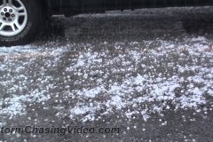
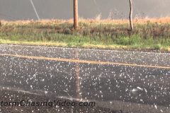
The first day of a series of severe weather days kicked off across Texas with a couple of severe storms northwest of DFW that produced large, spiked hailstones across northern Texas. Several more days of severe weather are expected with a major outbreak possible midweek. Meanwhile, this was just the kick off.
TRT – 2:33
Scene 1: Spiked 1.25″ hailstone being rotated in hand.
Scene 2: Two spiked stones and two normal stones compared to 50-cent piece.
Scene 3: Two vehicles pulled off the road during storm with NATS.
Scene 4: Vehicle drives by during storm with hail and leaf debris littering roadway.
Scene 5: Parked car with hail falling on grass.
Scene 6: Hail falling and bouncing on grass.
Scene 7: POV with oncoming traffic.
Scene 8: Traffic in hail.
Scene 9: Close-up of traffic in hail.
Scene 10: Two trucks drive in falling hail.
Scene 11: Close-up of hail on roadway.
Scene 12: Hail falling in puddle.
Scene 13, 14: Hail falling and bouncing in grass.
Scene 15: Close up of truck with hail falling.
Scene 16: Hail in grass.
Scene 17: Tight shot of hail in grass.
Scene 18: Chaser holding 4 hailstones in hand.
It may be Spring but the west central and northwestern Minnesota are getting slammed with another brutal winter storm system..
A mixture of snow, sleet and freezing rain fell over the area around Barnesville, MN which is in Clay County and just 22 miles southwest of the Fargo & Moorhead metro area.
This area was the focus due to a major wreck along Interstate 94 that shut the interstate down for most of the afternoon and into the evening. Several tractor trailers hauling livestock crashed, along with several other vehicles just south of the Barnesville, MN area on Interstate 94.
The highest wind gusts that I recorded in the truck was 52.5 mph.
Total Run Time: 8:51
Clip 01 Barnesville City City covered in snow with heavy snow falling and tree’s in the background for depth of field and motion.
Clip 02 Clay County Sheriff vehicle blocks the entrance to Interstate 94 due to the wreck just south of the entrance. High winds blow the camera around while trying to hold the shot.
Clip 03 POV Drive by of a large delivery van in the ditch.
Clip 04 POV Drive by shot of Semi Truck in the ditch
Clip 05 First drive by shot of the major crash scene on Interstate 94
Clip 06 Second drive by shot of the same scene of the major crash scene on Interstate 94. This scene is a faster pace.
Clip 07 Wide shot from the farm road of the cattle trucks crashed in the east bound ditch of Interstate 94.
Clip 08 Medium shot of one of the trucks the crashed.
Clip 09 Tight shot of the pigs outside of one of the crashed trucks.
Clip 10 Tight shot on the front end of one of the crashed trucks.
Clip 11 Workers cleaning up the scene and trying to get the pigs out of the first truck.
Clip 12 First truck with a wider shot with police and tow truck crews
Clip 13 Blowing snow over a field with a house in the background near the crash site.
Clip 14 Static shot of a stop sign in the foreground and rail road sign and trees in the back ground with blowing snow.
Clip 15 Tight shot of the stop sign with snow covering it.
Clip 16 Blowing snow static shot with trees in the background
Clip 17 Blowing snow static shot with a tree in the background
Clip 18 Semi truck driving towards the camera in the high winds and heavy snow.
Clip 19 Pickup truck driving towards the camera in the high winds and snow
Clip 20 Tight shot of high winds blowing cross the field.
Clip 21 Truck drives towards the camera in near white out conditions.
Clip 22 High winds blowing snow across the shot, trees in background.
Clip 23 High winds blowing snow across the highway to show the limited visibility.
Clip 24 High winds blowing snow across the highway.
Clip 25 Tighter shot of the high winds blowing snow across the highway.
Clip 26 Highway 108 and county road 30 signs in the high winds
Clip 27 Snow plow parked in the background with the Fergus Falls and Moorhead sign in the foreground with blowing snow.
Clip 28 Looking down shot of a snow plow on Interstate 94 driving towards the camera.
Clip 29 POV shot of a snow plow in front of the camera.
Clip 30 Passing shot of a snow plow from the dash camera.
Clip 31 Passing shot of a snow plow from the side camera.
Clip 32 Snow plow passing in oncoming traffic.
Clip 33 POV driving in heavy snow
Clip 34 POV driving in heavy snow
Clip 35 POV driving in heavy snow with a SUV with its hazard lights on.
Clip 36 POV driving in heavy snow and high winds
Clip 37 POV driving in heavy snow and high winds
Clip 38 POV driving in heavy snow and high winds from the grill camera.
Clip 39 POV driving in heavy snow and high winds from the grill camera.
Clip 40 POV driving in heavy snow and high winds following a Dodge Durango SUV
Clip 41 POV driving in heavy snow and high winds
Clip 42 Car in the ditch after dark (shot on the way home northwest of Fergus Falls.
A major winter storm hit the central Minnesota city of Saint Cloud hard before noon today. The storm dumped 9 inches of very heavy wet snow on the area and made driving extremely dangerous.
Total Run Time 6:17
Clip 1 Flags blowing in the heavy snow
Clip 2 So you think it is spring? Pull back shot of heavy snow covering branches with a creek flowing.
Clip 3 Tight shot of heavy snow on a pine tree that looks more like December then Mid April.
Clip 04 Ruler (in my back yard) showing Nine Inches of snow fell in Saint Cloud, MN.
Clip 05 The first sign of spring is the Robins and other song birds migrating into town. Today they are singing the blues.
Clip 06 Robins finding berries to eat that are on top of the heavy wet snow
Clip 07 POV shot of a snow plow almost taking off the front of my truck.
Clip 08 POV shot of a snow plow in Saint Cloud.
Clip 09 Tight shot of the wing plow
Clip 10 Snow plow gets stuck and spins the back tires.
Clip 11 POV driving in white out conditions.
Clip 12 Drive by of car in the ditch
Clip 13 Driving in heavy snow on Interstate 94.
Clip 14 Driving in heavy snow and a plow drives through the shot on Interstate 94.
Clip 15 POV Driving in heavy snow
Clip 16 POV Following snow plows on highway 23
Clip 17 POV White out conditions again on highway 23
Clip 18 Drive by shot of a car in the ditch
Clip 19 Drive by shot of a car in the ditch
Clip 20 Drive by shot of a sports car in the ditch.
Clip 21 Static shot of a car in the ditch
Clip 22 SUV spinning its wheels on ice
Clip 23 Static shot of a car in the ditch
Clip 24 Blowing snow
Clip 25 Static shot of a car in the ditch
Clip 26 Drive by shot of jackknifed semi and a massive backup on Highway 10
Clip 27 Static shot of the jack knifed semi
Clip 28 5th Wheel trailer got hit in an accident.
Clip 29 Police and Wrecker crews pull a tractor trailer out
Clip 30 Police and Wrecker crews pull another tractor trailer out of being stuck
Clip 31 Tracking shot of a snow plow
Clip 32 Snow plow driving towards the camera
Clip 33 Plowing snow with an old cabin in the background
Clip 34 Snow plows driving towards the camera with a side pov shot.
Clip 35 – 39 Crews clean up a wreck on Highway 23 where a car slid under a semi truck. Various shots of EMS, snow plows and police on scene.
Clip 40 Plowing snow down a country road on the west side of town.
Heavy snow and freezing fog started up during the overnight hours. B-Roll footage from around Duluth, MN from Canal Park down by the lake shore to the west side of town up on top of the city of the heavy snow.
Various footage shot from 11:00pm to 2:00am as the bands of heavy snow moved into the area.
To license this footage, contact http://www.StormChasingVideo.com
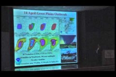
The following video is from the Douglas County, Kansas Severe Weather
Symposium on Saturday, March 9, 2013. Video uploaded at the request of the symposium organizers.
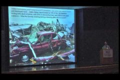
Bill Gallus, Iowa State University talks about the lessons learned from the debris of the 2011 tornadoes.
The following video is from the Douglas County, Kansas Severe Weather
Symposium on Saturday, March 9, 2013. Video uploaded at the request of the symposium organizers.
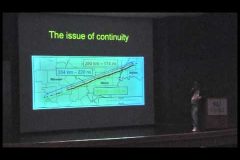
Dr. Chuck Doswell talks about the Tri-State tornado of March 18, 1925, A Reanalysis Project.
The following video is from the Douglas County, Kansas Severe Weather
Symposium on Saturday, March 9, 2013. Video uploaded at the request of the symposium organizers.
Dr. Russell S Schneider talks about Tornadoes, Derechos and the Storm Prediction Center. Recap of recent events & future directions.