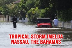
Aftermath footage from around Nassau, on the island of New Providence, The Bahamas, of the effects of Tropical Storm Imelda.
Video of flooded streets, traffic in the flood waters, pumps draining flood waters, and storm damage.
Shot Description
00:00 – Red Flags blowing at the beach with trees blowing in the winds.
00:08 – A silver Dodge pickup truck drives into deep waters.
00:15 – Traffic along the shoreline as the waves crash into the sea wall on West Pay Street.
00:26 – Strong winds are blowing sand and palm fronds around.
00:31 – People walking through deep floodwaters as a red Jeep slowly drives through the flooding.
00:50 – Water bubbling up from a storm sewer cover.
00:58 – Flooded field.
01:09 – Crews working to remove flood water with a large pump.
01:15 – Crews working on storm drainage infrastructure along the coastline.
01:51 – Traffic driving through an area that was flooded with sand still on the road on one side and flood waters on the other side.
02:00 – Flooding.
SID: Bahamas Video
#tropicalstorm #hurricane #Bahamas #nassau
To help support our freelancers, buy them coffee. https://www.buymeacoffee.com/stormchasing/
To License This Footage For Broadcast, Contact Video @ StormChasingVideo.com
Our Team Merch Store – https://stormchasingvideo.creator-spring.com
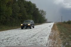
Multiple rounds of hail covering the road to 2-3 inches deep in central Waseca County and a full rainbow with rotating wall cloud.
Shot Description
0:00 – 1 to 1-1/2 inch Hail covering the roadway with narration
0:20 – 1 to 1-1/2 inch Hail covering the roadway and driving
0:32 – 1 to 1-1/2 inch Hail covering the roadway and a vehicle driving over it
0:42 – Hailing hard on trees with house nearby
0:52 – Hailing hard on trees, closer view
1:03 – Hail finishing up piled on grass and wider view of trees
1:07 – Water and hail washing down ditch and piling up while driving
1:25 – Driving after hail showing stripped leaves on road along with some hail in grass and on road
1:37 – Hail fog over silage-harvested corn
1:46 – Massive amounts of hail building up on car windshield and road – 3 inches deep
2:02 – Hail 3 inches deep on road way, near crops, and on vehicle
2:36 – Driving on 3 inches deep hail on road
2:50 – Hail covering yard and road with a wall cloud in the background
3:10 – Rotating wall cloud with partial dim rainbow
3:24 – Full rainbow with rotating wall cloud
3:49 – Dark wall cloud with some lightning
SID: Jarrod Schoenecker
To help support our freelancers, buy them coffee. https://www.buymeacoffee.com/stormchasing/
To License This Footage For Broadcast, Contact Video @ StormChasingVideo.com
Our Team Merch Store – https://stormchasingvideo.creator-spring.com
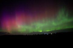
Solar winds hit the Earth last evening, causing a strong G3 geomagnetic storm. As a result, a stunning aurora display lit up the sky. The video package is a time-lapse of the Auroras dancing in the sky.
Shot Description
Clips 1-3.A looped timelapse of the Aurora display.
SID: Dirk Miller
#auroraborealis #northernlights #spaceweather
To help support our freelancers, buy them coffee. https://www.buymeacoffee.com/stormchasing/
To License This Footage For Broadcast, Contact Video @ StormChasingVideo.com
Our Team Merch Store – https://stormchasingvideo.creator-spring.com
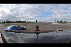
Yes, it is not storm chasing; it is car chasing, or practice video with a new 360 8K camera setup during the downtime between storm chasing seasons. We filmed this at the Brainerd International Raceway in Brainerd, MN, on a friend’s drifting car to test out the mounting setup and camera quality under extreme driving conditions.
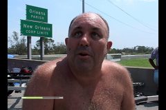
Here is something we found in the archives for the 20th anniversary of Hurricane Katrina. While cleaning up and working on decluttering the office, we found the long-lost edits of my Five-Part Series about Hurricane Katrina in New Orleans. This was initially produced for the now-defunct “Current TV” network.
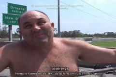
It was strange after Katrina. The footage was incredible, but I had never really done any interviews about being there for 20 years for anyone, just self-produced content. Yes, I really did have walking Pneumonia and a fever while chasing the storm, and I felt like crap, but I knew it was the storm of the decade.
For those wondering, why did I give one person a ride and not the other? Simple answer: Timing. If the man on Canal came up to me with a pet the next day, and asked for a ride to somewhere nearby that was dry, I would have said get in. You have to remember that, during the storm back in 2005, professional video cameras were huge. The front passenger seat of the SUV (GMC trail rental) was a huge camera mounted on a tripod that was strapped into the seat. The back seat and cargo area of the SUV were packed with survival gear, additional cameras, camera tapes, and computers. Remember, this was 2005, not 2025, when an iPhone could be used as a Movie Camera. After the storm, when I knew I could make it out and head west to Houston, I gave away most of the survival supplies to people at the hotel and the EMS staff at the airport, so the front seat and back seats were empty the next day.
To help support our freelancers, buy them coffee. https://www.buymeacoffee.com/stormchasing/
To License This Footage For Broadcast, Contact Video @ StormChasingVideo.com
Our Team Merch Store – https://stormchasingvideo.creator-spring.com
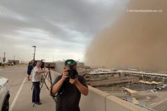
Footage from the airport of the massive dust storm that hit Phoenix, AZ, this evening. Video shows the massive dust storm moving over the city, and then finally it starts to Rain Dirt at the airport as the dust cloud overtakes the area.
Shot List:
00:01 – Footage of the massive wall of dust moving into the Phoenix, AZ metro.
00:19 – Camera pans around to show people watching the massive dust cloud roll into and overtake the airport.
00:41 – The dust cloud is at the edge of the airport.
00:48 – The dust cloud is overtaking the airport and about to overtake the cameraman.
01:14 – It starts to rain dirt from the dust cloud.
01:16 – You can not even see the end of the concourse at the airport when looking down from the top of the parking ramp.
01:28 – More B-Roll of the dust storm as the
To help support our freelancers, buy them coffee. https://www.buymeacoffee.com/stormchasing/
To License This Footage For Broadcast, Contact Video @ StormChasingVideo.com
Our Team Merch Store – https://stormchasingvideo.creator-spring.com
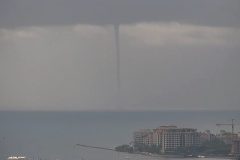
A large waterspout touched down just outside the Port of Miami, Florida, at 10:20am this morning as cruise ships prepare to depart on trips today. Various shots of the waterspout, storm clouds over Biscayne Bay and Port Miami, Miami Beach skyline, and cruise ships at the port. No audio.
Shot Description
00:00 Wide shot of waterspout at Port Miami, and then zooms in on it.
00:44 Waterspout SE of port.
00:52 Waterspout SE of port varied.
01:01 Cruise ships Freedom of the Seas and Norwegian Gem at Port Miami.
01:10 Cruise ship Norwegian Gem.
01:17 Cruise ship Freedom of the Seas.
01:26 Cruise ship Carnival Conquest.
01:34 Wide shot of Venetian Island and Miami Beach skyline with stormy skies.
01:38 Wide shot of Port Miami and stormy skies.
01:44 Wide shot of North Miami Beach skyline and stormy skies.
01:48 Med shot of Hibiscus, Palm, and Star Islands and stormy skies.
SID: Brian Dombrowski
#waterspout #tornado #flwx
To help support our freelancers, buy them coffee. https://www.buymeacoffee.com/stormchasing/
To License This Footage For Broadcast, Contact Video @ StormChasingVideo.com
Our Team Merch Store – https://stormchasingvideo.creator-spring.com
Here is the video clip where I thought I was going to witness multiple chasers die in the Henry, SD #tornado #sdwx after getting too close as the farm disintegrated and flew over them.
See the full video at https://youtu.be/vvUmErF9UZ8
The birth of the Henry, SD tornado on 7/27/2025 from about 150 yards away.
See the full video at https://youtu.be/vvUmErF9UZ8
#tornado #sdwx
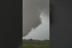
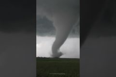
A large, violent tornado forms right in front of the camera in an open field, then moves to the east (right) and destroys a farm.
Large (HUGE) debris is thrown into the air as the farm is obliterated. Luckily, nobody was home at the time the tornado hit the farmstead, but a horse was reported to have been put down due to its injuries.
Shot Description
00:01 – Time-lapse of the tornado forming on a wide-angle camera.
00:15 – Perfect tornado forms in the field right in front of the camera.
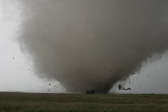
01:10 – The tornado grows in strength and starts ripping apart trees and vegetation on the other side of the field.
01:59 – Close-up of the large, destructive tornado hitting the farm and destroying it.
03:32 – Part of the same clip, but this is where the tornado destroys the farm.
04:04 – The Tornado moves past the farm, and a large drill bit tornado is on the ground with a ton of deadly flying debris spinning around it.
04:33 – The tornado now moves to the south and continues destroying anything in its way.
05:37 – Wide-angle rooftop camera of the tornado from start to hitting the farm.
To help support our freelancers, buy them coffee. https://www.buymeacoffee.com/stormchasing/
To License This Footage For Broadcast, Contact Video @ StormChasingVideo.com
Our Team Merch Store – https://stormchasingvideo.creator-spring.com
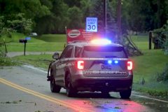
Severe storms with embedded tornadoes worked through west-central Minnesota on Sunday evening, July 27, 2025. Widespread damage was reported across parts of Kandiyohi County, including the towns of Sunburg and New London, Minnesota, as well as their surrounding areas. The following video was captured from the town of New London and the surrounding area, showing damage from the severe storms that included a roof ripped off a barn, a silo with significant damage, a tree down on a home, roads closed due to downed trees blocking them, and several large trees taken down.
Shot Description
00:00 Two videos of emergency vehicles responding to calls in the New London area following severe weather. The first video shows a fire truck with lights and sirens, while the second video shows a fire truck driving by with just lights on along Minnesota State Highway 9.
00:17 Two videos, shot from medium and close angles, of a grain silo with significant damage in the town of Sunburg, Minnesota.
00:32 Three shots showing the roof ripped off a pull burn along Minnesota State Highway 9 just west of the town of Sunburg, Minnesota. The first shot is a wide shot of the damage to the barn, the second is a medium shot, and the third is a shot of the roof of the barn blown to the southeast into a pocket of trees.
00:55 Two clips of multiple pine trees blown over in the front yard of a home in Sunburg, Minnesota. The first clip has a member of the local volunteer fire department driving by with lights on their fire response vehicle.
01:10 A clip of another Sunburg volunteer firefighter pulling up to a downed tree in a fire rig with lights on.
01:19 Four separate videos of a Kandiyohi County Sheriff squad blocking the road in New London, Minnesota, with lights on due to a large tree that fell and made the road unpassable. In the first two clips, a white SUV can be seen turning around.
01:49 Two clips of a large tree that was blown over onto a home in the town of New London.
02:03 Three clips of a large tree that was snapped at the base and fell into the road.
02:26 Two clips from outside of New London of a large trailer that was blown upside down and into the side of a building along County Road 40 NE.
03:41 A video of a tree that was split down the middle and blown over following severe weather outside of the town of New London.
02:45 Three clips of large trees that were blown over following severe weather just outside the town of New London. In the first clip, sirens can be heard in the background as emergency responders respond to various calls in the area following the severe storms.
03:06 Video of the sign for the Hope Lutheran Church in Sunburg, Minnesota, damaged following severe storms Sunday evening.
SID: Will Wight
To help support our freelancers, buy them coffee. https://www.buymeacoffee.com/stormchasing/
To License This Footage For Broadcast, Contact Video @ StormChasingVideo.com
Our Team Merch Store – https://stormchasingvideo.creator-spring.com
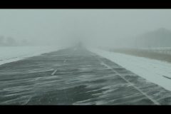
Live stream from the powerful winter storm in Northern Iowa and Southern Minnesota.
Live GPS tracking link: http://www.livenewsvideonetwork.com/scvp/scv-stringers/doug-kiesling/live-track/
Copyright 2015 StormChasingVideo.com & LiveNewsVideoNetwork.com
*** NO THIRD PARTY USE W/O LICENSE ***
*** Contact StormChasingVideo.com for Licensing ***
SID=DougK
Hurricane Katrina Stock Video Catalog Remastered 2025 Master – Tape 5
To commemorate the 20th anniversary of Hurricane Katrina, we have remastered and uploaded our master time-coded catalogs.
All of the videos have been reviewed and remastered into 1920×1080 HD ProRes 422 format.
This footage is part of our five-part series from the New Orleans, LA, metro area, which was filmed on August 30, 2005.
Hurricane Katrina Archive Master Tape 5 of 5
Date: 8/30/2005
Hurricane Katrina Stock Video Catalog Remastered 2025 Master Tape 05
This footage catalog documents the start of the rescues from the area on Interstate 10 and the 17th Street Canal that failed during Hurricane Katrina. The footage has multiple eyewitness interviews from survivors telling their story, along with people being dropped off by air-boats and helicopters.
Footage included one of the flooded pumping stations along Interstate 12 and lots of aftermath of the city underwater.
Image Size: FHD 1920×1080 – 29.97FPS
Apple ProRes 422HQ
Total File Runtime: 38:15:26
00:10 – Footage of people walking through the flood waters.
00:30 – Footage of dozens of ambulances beginning to stage on Interstate 10 as the area was now being taken over by FEMA, as crews from multiple states were on scene to try to set up and coordinate the rescue of tens of thousands of citizens who were trapped in the flooding.
15:13 – Multiple survivors are being dropped off by boat after being rescued from the flooding.
18:23 Footage of the I-10 pumping station and station pipes that were submerged by floodwaters.
23:24 – The birth of the Cajun Navy as local residents from around the area line up with their boats to try and help rescue people trapped in the flood waters.
26:53 – Recovery staging area where people were brought to organize transport to shelters or for medical attention. Footage shows dozens of ambulances staged to assist, Air National Guard and US Coast Guard helicopters dropping off rescued individuals, and the start of the evacuation of survivors out of the area by bus.
36:15 – Final interview with a resident describing what he went through during the storm and after the levees failed.
37:39 – Final scenes showing the aftermath in Kenner where there was the majority of wind damage from the hurricane and not flooding.
#Hurricane #hurricanekatrina #weather #neworleans #nola
To help support our freelancers, buy them coffee. https://www.buymeacoffee.com/stormchasing/
To License This Footage For Broadcast, Contact Video @ StormChasingVideo.com
Our Team Merch Store – https://stormchasingvideo.creator-spring.com
Hurricane Katrina Stock Video Catalog Remastered 2025 Master – Tape 04
To commemorate the 20th anniversary of Hurricane Katrina, we have remastered and uploaded our master time-coded catalogs.
All of the videos have been reviewed and remastered into 1920×1080 HD ProRes 422 format.
This footage is part of our five-part series from the New Orleans, LA metro area that was filmed on August 29, 2005.
Hurricane Katrina Archive Master Tape 4 of 5
Date: 8/29/2005
Hurricane Katrina Stock Video Catalog Remastered 2025 Master Tape 04
Image Size: FHD 1920×1080 – 29.97FPS
Apple ProRes 422HQ
Total File Runtime: 55:10:10
The Escape from Hurricane Katrina Flooding and levee failure in New Orleans, LA. This is a continuation from master tape 3.
00:12 – The Point Of View (POV) escape footage from New Orleans, LA, as the levee system failed and the city began to flood. The footage starts out on Interstate 10 and the 610 split, which was no longer an option to escape the heart of the town due to the massive flooding under the “Railroad Underpass” on the west side of the city. The camera moves back the way it came on the interstate, going the wrong direction, until the first available exit. The videographer used GPS and mapping to find an alternate route around the rising flood waters on the southwest side of New Orleans to get back to Interstate 10. This was all done while driving over downed trees, through flooding, and extreme winds as the hurricane’s eye wall moved away from the area. This is some of the last footage of these neighborhoods before the flooding overtook them.
14:21 – After driving through flooded and debris-filled roads to get to the next entrance ramp, the ramp was filled with several feet of water that would not permit anyone to drive through it and onto the interstate. Yet another route had to be located to the west.
25:45 – After finally finding a way around the rising flood waters and back onto higher ground on Interstate 10, the flooding was still a problem, as well as the flying debris striking the vehicle.
27:44 – After making it back to the area around the airport in Kenner, LA. The aerial view of the area shows the flooding all around the airport with the roads impassible. Footage shows the damage around the area of the Airport and Kenner, LA.
44:11 – Aftermath footage from around Kenner, LA and the New Orleans International Airport. Footage shows the flooding around the north side of the airport as the frontage road is under several feet of water. Flooded our vehicles were left on the side of the road. The security fence around the airport was destroyed. Airport taxiways were lowered and damaged by the wind. Airport signs are down and littering the roadway. Additional footage from inside the airport as passengers waited out the hurricane in the airport terminal. Damage to the terminal roof and windows. Just about every vehicle that was parked at the airport showed damage from flying debris.
50:20 – Footage from outside the NOLA airport that shows the extent of the wind damage with damaged hangars, tipped over trailers, and downed utility poles. Additional footage from around the south side of Kenner, LA, where there was no flooding, only wind damage from the hurricane, showing destroyed gas stations, downed traffic lights, and damaged buildings.
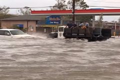
51:37 – By contrast to the south side of the airport, where the levee system worked, the north side of the airport had several feet of water on the roadways, making it almost impossible to pass without a high-profile vehicle. Video shows trucks driving through the high water while other vehicles are just stalled out in the high water, as people are walking through the high flood waters. Additional footage of cars flooded up to the windows
54:38 – Video ends with a scene of the flooded out airport radio navigation equipment at the north end of the New Orleans International Airport and another damaged building on the north side of the airport.
#Hurricane #hurricanekatrina #weather #neworleans #nola
To help support our freelancers, buy them coffee. https://www.buymeacoffee.com/stormchasing/
To License This Footage For Broadcast, Contact Video @ StormChasingVideo.com
Our Team Merch Store – https://stormchasingvideo.creator-spring.com
Hurricane Katrina Stock Video Catalog Remastered 2025 Master – Tape 03
To commemorate the 20th anniversary of Hurricane Katrina, we have remastered and uploaded our master time-coded catalogs.
All of the videos have been reviewed and remastered into 1920×1080 HD ProRes 422 format.
This footage is part of our five-part series from the New Orleans, LA metro area that was filmed on August 29, 2005.
Hurricane Katrina Archive Master Tape 3 of 5
Date: 8/29/2005
Hurricane Katrina Stock Video Catalog Remastered 2025 Master Tape 03
Image Size: FHD 1920×1080 – 29.97FPS
Apple ProRes 422HQ
Total File Runtime: 58:27:10
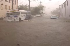
This footage was shot in the morning hours after sunrise in downtown New Orleans, LA, as the strongest winds hit the area. It was filmed along Canal Street and in the French Quarter of the city as large debris was flying through the area, and extreme winds damaged the taller buildings.
Footage also includes the start of the escape from New Orleans drive where they attempted to drive out of the rapidly rising flood waters as the levees started to fail around the city.
00:10 – The footage starts out on Canal Street during the peak winds of Hurricane Katrina hitting New Orleans, LA, and shows Canal Place and the Sheraton Hotel sustaining major damage from the extreme winds and flying debris. The footage was shot on Canal Street in front of the Marriott Hotel. The footage shows EMS personnel checking out the storm from the Marriott entrance, along with the roofs of the Sheraton coming apart from the significant winds around the skyscrapers. Video of a large glass wall of Canal Place that was blown in from the extreme winds, and a lone police officer patrolling the downtown streets of New Orleans.
20:18 – Footage continues to show different parts of the French Quarter of New Orleans during Hurricane Katrina, as the winds are still ripping through the city. A lot of large debris is still being picked up in the extreme wind gusts as the hurricane eye wall and the worst of the winds begin to subside, and people are seen walking around the streets of NOLA.
35:00 – The part where a resident told the cameraman (who was working with “Walking Pneumonia” at the time) about rumors of the levee system failing. A phone call to The Weather Channel’s news desk could not confirm the reports of the levee failure, as it appeared that freshwater flooding was still occurring.
40:44 – The start of the flooding and evacuation from downtown New Orleans, LA as the water is starting to rise up outside of the French Quarter area. POV Driving footage shows the extensive damage around the city from down tree’s, power lines, and structural damage.
#Hurricane #hurricanekatrina #weather
To help support our freelancers, buy them coffee. https://www.buymeacoffee.com/stormchasing/
To License This Footage For Broadcast, Contact Video @ StormChasingVideo.com
Our Team Merch Store – https://stormchasingvideo.creator-spring.com
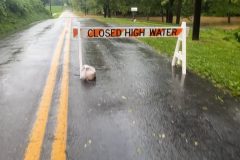
According to the National Weather Service office in State College, PA, law enforcement was reporting heavy rain had fallen in Mount Joy Township, with around 4-6 inches of rainfall reportedly falling and an additional 2-3 inches forecast to fall. Flash Flooding was actively occurring in the township, which resulted in the NWS issuing a Flash Flood Warning for the area until 8:30 PM EST. The following video was captured from Mount Joy Township, showing the ongoing flash flooding.
Shot Description
00:00 Video panning from a road closed sign, water flowing over a roadway, and flooding a neighboring yard and driveway.
00:16 Video of heavy rain falling showing a completely flooded field up to the roadway.
00:26 A couple of videos of a truck driving through a flooded roadway and standing water in town.
00:52 Various videos showing a heavily flooded ditch and creek, and the road at the end of the street being closed as water is overtaking the road. Vehicles have to turn around and use the driveway due to the road closure.
01:41 A couple of videos of fast-moving water flowing through the backyard of several homes and flooding the backyards of homes further down.
02:08 Video of a road flooded and being overtaken by high water after heavy rains.
02:19 Video showing fast-moving water from flash flooding running into a culvert under a roadway, with debris stuck on the fence and railing of the bridge. The videographer is talking about the debris stuck on the bridge/culvert.
02:53 Video of water flowing over the roadway from a neighboring field after heavy rain, and then panning to a flooded ditch on the other side of the road and the large area of flooding.
03:16 Narrated video talking about all the water flowing into the already flooded creek following the heavy rains.
SID: Katie Lock
To help support our freelancers, buy them coffee. https://www.buymeacoffee.com/stormchasing/
To License This Footage For Broadcast, Contact Video @ StormChasingVideo.com
Our Team Merch Store – https://stormchasingvideo.creator-spring.com
Hurricane Katrina Stock Video Catalog Remastered 2025 Master – Tape 02
To commemorate the 20th anniversary of Hurricane Katrina, we have remastered and uploaded our master time-coded catalogs.
All of the videos have been reviewed and remastered into 1920×1080 HD ProRes 422 format.
This footage is part of our five-part series from the New Orleans, LA metro area that was filmed on August 29, 2005.
Hurricane Katrina Archive Master Tape 2 of 5
Date: 8/29/2005 Early Morning To Sunrise.
Footage was shot in the early morning of 8/29/2005 in Kenner, LA
and New Orleans, LA, as Hurricane Katrina moved inland from the
Gulf of Mexico.
The video shows the worst of the extreme winds and flying debris in
The New Orleans, LA, metro area before the levees failed and flooded most of the city.
00:10 – Scenes from Kenner, LA, as firefighters battle with hurricane-force winds as they try to control a fire that appeared to have started by power lines shorting out. Footage shows Kenner, LA, fire crews trying to contain the fire from spreading in the high winds. Footage of power lines shorting out and scenes of high winds and flying debris.
04:02 – Early morning pre-dawn footage while driving into New Orleans, LA as Hurricane Katrina started to move onto the coast of southern Louisiana. The footage includes pre-dawn dash camera and outside footage from the main camera that shows the flooding starting from the heavy rain. This part also includes the first signs of high wind damage from the tropical storm force and hurricane force winds.
07:40 – Footage in the heart of the city from Canal Street. The video starts off with Storm Chaser Douglas Kiesling trying to set up a camera in the extreme winds and heavy rain. The video continues with scenes from around Canal Street showing the winds and rain in the early morning hours, and the police try to patrol the area.
09:24 – Winds begin to get more violent and throw large debris around the streets of New Orleans.
12:38 – A guy is standing out in the middle of Canal Street during Hurricane Katrina, looking like he’s on something… And then continue to drive around the area looking for more damage.
16:01 – Storm Damage: A tree lies across the roadway as the western eye wall of Hurricane Katrina approaches downtown New Orleans, and debris begins to fall on Canal Street. Scenes of a billboard ripped apart and sheet metal littering the ground.
17:55 – Scenes from around the Super Dome as the street begins to become covered in flood waters. The winds intensify as the storm’s damage becomes increasingly visible on the roads, with the Hurricane Eye Wall moving closer to NOLA.
25:37 – Right before the power goes out to the city. POV dash camera as the power is knocked out in the downtown area, and all the street lights and traffic signals go dark. At this point, the winds intensify drastically as the western part of the Hurricane Eye Wall slams downtown New Orleans just before sunrise. Lots of trees are now blocking multiple roads in downtown NOLA.
34:41 – Extreme winds hit the area, and a Police car is parked with the officers watching the city take a beating from Hurricane Katrina. Footage continues as the sun rises, and the total wind damage can be seen in NOLA.
38:44 – The worst of the western Eye Wall from Katrina slams into the city with Category 4 storm force winds. Footage shot outside in the Cat 4 winds on Canal Street as debris is flying all around the camera. Footage of the Harrah’s New Orleans Casino being hit with debris. Debris flying off of taller buildings and pretty much total chaos on Canal Street.
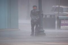
52:02 – Repositioning to a new location to document as much of the storms fury as the eye wall is over downtown New Orleans. This is where the classic scene of the man hanging on for his life with only a garbage bag to protect him from the storm, as he tries to get over to safety to get out of the storm.
Image Size: FHD 1920×1080 – 29.97FPS
Apple ProRes 422HQ
Total File Runtime: 54:39:19
To help support our freelancers, buy them coffee. https://www.buymeacoffee.com/stormchasing/
To License This Footage For Broadcast, Contact Video @ StormChasingVideo.com
Our Team Merch Store – https://stormchasingvideo.creator-spring.com
To commemorate the 20th anniversary of Hurricane Katrina, we have remastered and uploaded our master time-coded catalogs.
All of the videos have been reviewed and remastered into 1920×1080 HD ProRes 422 format.
This footage is part of our five-part series from New Orleans, LA metro area that was filmed on August 27, 2005 and August 28, 2005.
Total Catalog Run Time 54:24:05
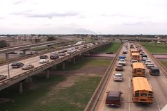
05:00 – The footage starts out near the New Orleans International Airport as the Contra Flow evacuation begins. The footage includes interviews of residents leaving and the start of the Contra Flow, where the east-bound lanes of Interstate 10 are switched for people to drive west-bound on the east-bound lanes.
07:57 – Shot during the overnight hours and into 8/28/2005. The footage continues to show the last night of Bourbon Street in the French Quarter as Category Four Hurricane Katrina was moving closer and closer to shore, with the Big Easy, NOLA, New Orleans, predicted to be ground zero for landfall per https://www.nhc.noaa.gov/archive/2005/KATRINA_graphics.shtml
16:09 – As Hurricane Katrina was upgraded to a Category Five storm, the mood in the city changed drastically, and the Hurricane Contra Flow on Interstate 10 was now packed at the entrance at Veterans Blvd. and Williams Blvd as police and national guard units tried to keep the traffic moving in an orderly pace. Footage of the Contra Flow from above the traffic and from ground level. Scenes of the skyline and the airport with one of the last flights leaving.
41:15 – Footage of the last minute work done to build up a temporary levee around the New Orleans International Airport by the East Jefferson Levee District. Interviews with the Mayor of Kenner, LA, and the Levee District President.
46:02 – Final footage from downtown New Orleans, LA, and the French Quarter as the outer bands of Hurricane Katrina begin to move over the region, and the wind and rain begin to pick up. Footage shows people are still partying on Bourbon Street as the historic storm is about to destroy the region.
51:48 – Final footage from 8/28/2005 showing the area as the tropical winds and heavy rain are hitting the area around Lake Pontchartrain in Kenner, LA at the Pontchartrain Center. The video shows the storm surge starting to push the lake levels upwards at the shoreline and flood a parking lot. Footage shows police actively patrolling the area.
To help support our freelancers, buy them coffee. https://www.buymeacoffee.com/stormchasing/
To License This Footage For Broadcast, Contact Video @ StormChasingVideo.com
Our Team Merch Store – https://stormchasingvideo.creator-spring.com
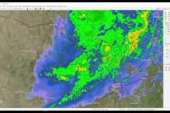
We have compiled a radar loop with audio of some of the first National Weather Service Flash Flood warnings to help better understand how the storms lingered over the same area.
The Radar loop from KEWX starts at 7:00 AM on July 3rd, 2025 and, continues through July 4th at 7:38 PM when the storm system begins to move out of the area.
The times listed on the upper right portion of the screen are in ZULU time. You will need to subtract Five Hours to get the correct local time for the area. (I.E. 12:03:57 Z = 7:03:57 AM).
The Green boxes that appear on the screen indicate the areas where the National Weather Service has issued Flash Flood Warnings.
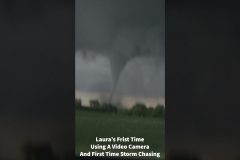
Hey everyone, Doug here.
I’m still reviewing the 5 hours of footage from Saturday, but I wanted to share a short highlight time-lapse video of what my 9-year-old daughter, Laura, and I saw of the tornado outbreak near Clear Lake, SD, on June 28, 2025.
This was her first time accompanying me on a storm chase, and it was one of the first real chases I’ve been on this year, as I haven’t been able to chase much due to family obligations. She counted seven (7) different tornadoes touching down before sunset.
It is safe to say the next generation of storm chasers will be amazing.
She even outdid me on the “Fn Wedge” comment from the Quinter Kansas tornado I shot in 2008, with a brand-new tagline that will make all the veteran chasers nod and salute because “Oh Dude, It Destroyed It, It Just Destroyed It!!!!”
Please share this link; do not download and re-upload our content to your social media page.
Music from epidemicsound.com
Song: Defector – Isaac Elliott
To help support our freelancers, buy them coffee. https://www.buymeacoffee.com/stormchasing/
To License This Footage For Broadcast, Contact Video @ StormChasingVideo.com
Our Team Merch Store – https://stormchasingvideo.creator-spring.com
Video clips from a 9-year-old storm chaser’s perspective. Laura Kiesling went tornado chasing for the first time with her Dad, the owner of StormChasingVideo.com, and multiple tornadoes on the 6/28/2025 near Clear Lake, South Dakota.
© Doug Kiesling & Laura Kiesling – StormChasingVideo.com
To License This Footage For Broadcast, Contact Video @ StormChasingVideo.com
Our Team Merch Store – https://stormchasingvideo.creator-spring.com
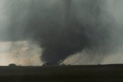
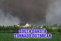
Multiple destructive tornadoes strike near the community of Clear Lake, South Dakota. The most violent tornado wipes out a farmstead.
All footage shot during evening daylight on June 28, 2025 in/near Clear Lake, South Dakota by Storm Chasers and Meteorologists Juston Drake and Simon Brewer
Shot Description
00:00 A large cone-shaped tornado twists next to the road.
00:20 A violent tornado destroys a farmstead.
00:48 Dramatic, strong, cone-shaped tornado.
01:19 A tornado writhing like a snake in the sky next to the road.
01:32 Tornado crosses highway.
01:51 Strong tornado destroys barn.
02:09 Very dramatic tornado.
03:33 Stout, stovepipe-shaped tornado.
03:41 Tornado ropes out and fades away.
SID: Simon Brewer Juston Drake
#Tornado #southdakota #tornadooutbreak
To help support our freelancers, buy them coffee. https://www.buymeacoffee.com/stormchasing/
To License This Footage For Broadcast, Contact Video @ StormChasingVideo.com
Our Team Merch Store – https://stormchasingvideo.creator-spring.com
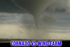
A dramatic-looking tornado hits farms and passes through wind farms near the community of Hannover, North Dakota
All footage shot during evening daylight on June 27, 2025, in/near Hannover, North Dakota by Storm Chasers and Meteorologists Juston Drake and Simon Brewer.
Shot Description
00:00 Several clips of a large cone-shaped tornado racing through a field filled with large wind turbines (Wind Farm).
00:54 Rope-shaped tornado next to a vehicle.
01:34 Debris cloud from the tornado spinning up right next to the vehicle.
01:57 Rope funnel cloud near Bismarck, ND.
SID: Simon Brewer Juston Drake
#northdakota #tornado #tornadoes #weather #ndwx
To help support our freelancers, buy them coffee. https://www.buymeacoffee.com/stormchasing/
To License This Footage For Broadcast, Contact Video @ StormChasingVideo.com
Our Team Merch Store – https://stormchasingvideo.creator-spring.com
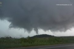
Multiple Tornadoes hit Wisconsin and Minnesota, including a multi-vortex Tornado near La Crosse, Wisconsin, and a multi-vortex tornado near Hokah, Minnesota.
All footage shot during evening daylight on June 25, 2025, in/near La Crosse, Wisconsin, and Hokah, Minnesota by Storm Chasers and Meteorologists Juston Drake and Simon Brewer
Shot Description
00:00 Close cone tornado near La Crosse, WI.
00:32 Tornado crosses next to storm chasers.
00:50 Large multi-vortex tornado
01:23 Time lapse of multi-vortex tornado
01:34 Multi-vortex tornado near Hokah, Minnesota
02:11 Dramatic lightning strikes.
02:19 Rotating wall cloud over La Crosse, Wisconsin.
SID: Simon Brewer Juston Drake
#WIWX #tornado #stormchasing #stormchasers
To help support our freelancers, buy them coffee. https://www.buymeacoffee.com/stormchasing/
To License This Footage For Broadcast, Contact Video @ StormChasingVideo.com
Our Team Merch Store – https://stormchasingvideo.creator-spring.com