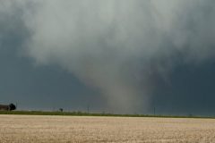
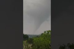
A large, violent tornado and another cone-shaped tornado near the town of South Plains, Texas.
All footage shot during evening daylight on April 24, 2025 near South Plains, Texas by Meteorologists and Storm Chasers Juston Drake and Simon Brewer.
Shot Description
00:00 large violent tornado
00:20 massive mesocyclone with large tornado
00:33 large tornado
00:51 cone tornado over town
SID: Simon Brewer Juston Drake
#weather #texas #tornado #tornadoes #climate
To help support our freelancers, buy them coffee. https://www.buymeacoffee.com/stormchasing/
To License This Footage For Broadcast, Contact Video @ StormChasingVideo.com
Our Team Merch Store – https://stormchasingvideo.creator-spring.com
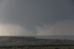
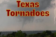
Second tornado of the day. This larger tornado affected areas of the Texas Caprock northwest of Matador, Texas.
Shot Description
0:00-0:42 Tornado on the ground in open country northwest of Matador, Texas. Visibility was not ideal with a lot of haze and fog in the air, and the sun peeking out behind the storm. The tornado touches down sporadically, occasionally with a visible dust cloud.
0:42-1:27 Tornado has become larger and somewhat closer, and is quickly obscured by rotating rain curtains.
SID: Chris McBee
#tornado #Texas #weather #climate
To help support our freelancers, buy them coffee. https://www.buymeacoffee.com/stormchasing/
To License This Footage For Broadcast, Contact Video @ StormChasingVideo.com
Our Team Merch Store – https://stormchasingvideo.creator-spring.com
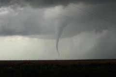
Tornado north of South Plains, TX on the afternoon of April 24, 2025
Shot Description
Long shot of a tall thin tornado as it snakes down to the West Texas Plains. Tornado was on the ground for around 5 minutes.
SID: Chris McBee
#tornado #texas #weather #climate
To help support our freelancers, buy them coffee. https://www.buymeacoffee.com/stormchasing/
To License This Footage For Broadcast, Contact Video @ StormChasingVideo.com
Our Team Merch Store – https://stormchasingvideo.creator-spring.com
Powerful supercell thunderstorm dumps massive amounts of golfball-sized hail, causing dangerous flash flooding near Fort Stockton, Texas.
Shot Description
00:00 Deep hail, flash flood, and rainbow
00:26 Hail covers the road
00:47 Flash flooding from deep hail and heavy rain
01:57 Logs and debris are racing across the road in a flash flood
SID: Simon Brewer Juston Drake
#flooding #flashflood #hail #texas #weather
To help support our freelancers, buy them coffee. https://www.buymeacoffee.com/stormchasing/
To License This Footage For Broadcast, Contact Video @ StormChasingVideo.com
Our Team Merch Store – https://stormchasingvideo.creator-spring.com
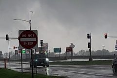
Severe weather moved through the central United States on Easter Sunday, bringing tornado warnings and strong storms. The following video was captured in the city of Kingdom, Missouri, showing the tornado sirens going off as a tornado warned storm tracked into the city.
Shot Description
00:00 Video of tornado sirens going off in the city as law enforcement drives by with lights and sirens on.
00:09 Video of the tornado siren going off in the background, with a shot of the water tower for Kingdom City, MO.
00:20 Medium shot under a gas station canopy of vehicles at the bumps, rain is falling, and the tornado siren is going off.
00:31 Medium shot of moderate to heavy rain falling from the front doors of a gas station as the tornado siren is going off.
00:42 Wide shot of dark, ominous clouds in the background from the front of the gas station as the tornado siren is going off.
00:50 Another medium shot from the gas station of vehicles at the pumps and the siren going off.
01:03 A shot showing an emergency alert on a cellphone for a Tornado Warning around 2:15 PM as tornado sirens can be heard in the background.
01:12 Video of heavy rain falling in the middle of a severe warning storm.
SID: Sara Bruce
#MOWX #severeweather #tornado
To help support our freelancers, buy them coffee. https://www.buymeacoffee.com/stormchasing/
To License This Footage For Broadcast, Contact Video @ StormChasingVideo.com
Our Team Merch Store – https://stormchasingvideo.creator-spring.com
Tornadoes touched down over Tom Green County, Texas on 4/19/2025
SID: Joseph Idler
#weatherevents #weatherphenomena #weather
Music by Def Lev – Licensed Via Epidemic Sound
To help support our freelancers, buy them coffee. https://www.buymeacoffee.com/stormchasing/
To License This Footage For Broadcast, Contact Video @ StormChasingVideo.com
Our Team Merch Store – https://stormchasingvideo.creator-spring.com
Raw footage of a long-track tornado that was on the ground for over ten minutes, west of Carlsbad, Texas, in Tom Green County.
Shot Description
00:01 – Driving and tracking the tornado.
00:20 – Footage of the tornado on the ground for several minutes.
03:48 – Several clips of a large tornado on the ground over a ranch.
SID: Joseph Idler
#Texas #tornado #texasstormchasers #texasstormchasing
To help support our freelancers, buy them coffee. https://www.buymeacoffee.com/stormchasing/
To License This Footage For Broadcast, Contact Video @ StormChasingVideo.com
Our Team Merch Store – https://stormchasingvideo.creator-spring.com
Several severe thunderstorms were affecting the Oklahoma City metro area. This severe storm had a hail core that passed directly over my home in Moore, Oklahoma. Hail stayed around quarter-size or smaller.
Shot Description
0:00-1:20
Panning shots, looking north, as a hail core overtakes my home from the south. Hail can be seen collecting on the driveway and bouncing in the front yard.
SID: Chris McBee
#hailstorm #okwx
To help support our freelancers, buy them coffee. https://www.buymeacoffee.com/stormchasing/
To License This Footage For Broadcast, Contact Video @ StormChasingVideo.com
Our Team Merch Store – https://stormchasingvideo.creator-spring.com
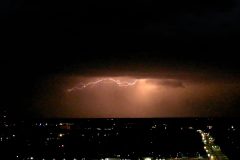
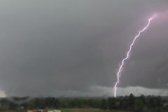
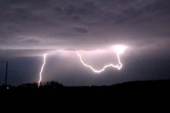
Testing out some drone operations outside of a thunderstorm that was dropping some lightning over Benton, County, MN tonight.
To help support our freelancers, buy them coffee. https://www.buymeacoffee.com/stormchasing/
To License This Footage For Broadcast, Contact Video @ StormChasingVideo.com
Our Team Merch Store – https://stormchasingvideo.creator-spring.com
Clouds of pine pollen in slow motion exploding into the air that is triggering allergies across the region. Footage of tree flowers and pollen covering cars.
Shot Description
Slow motion clouds of pollen from pine trees (three shots)
Pine catkins (no sound)
Cherry blossoms (no sound)
Car covered in pollen (two shots)
SID: William Hark
#allergies #allergy #pollen #slowmotion #spring
To help support our freelancers, buy them coffee. https://www.buymeacoffee.com/stormchasing/
To License This Footage For Broadcast, Contact Video @ StormChasingVideo.com
Our Team Merch Store – https://stormchasingvideo.creator-spring.com
Power flash and debris falling around vehicle as large rain-wrapped tornado passes next to Gilmer, Texas on another big severe weather outbreak. Frequent close lightning and high winds.
All footage shot in/near Gilmer, Texas during afternoon daylight on April 4, 2025 by Meteorologists and Storm Chasers Juston Drake and Simon Brewer
Shot Description
00:00 dramatic lightning next to large wall cloud
00:15 tornadic storm bears down on Gilmer, Texas
00:24 rain-wrapped tornado develops
01:16 power flash and debris raining from sky as large rain-wrapped tornado passes nearby
01:28 trees in road
01:42 severe winds from tornadic storm
02:11 supercell and lightning
SID: Simon Brewer Juston Drake
#txwx #lightning #tornado #weather
To help support our freelancers, buy them coffee. https://www.buymeacoffee.com/stormchasing/
To License This Footage For Broadcast, Contact Video @ StormChasingVideo.com
Our Team Merch Store – https://stormchasingvideo.creator-spring.com
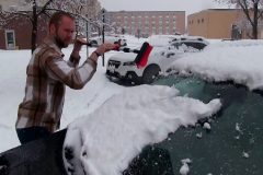
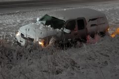
Heavy snow fell across Central and Northern Minnesota on Wednesday, April 2, 2025, with reports across parts of Stearns County reporting 3-5 inches by Wednesday afternoon, which resulted in difficult travel conditions across the region. The following video was captured in St Cloud, Minnesota, showing the heavy snowfall and hazardous travel conditions this afternoon.
Shot Description
00:00 Two medium clips of students walking between St Cloud State University classes show heavy snow falling.
00:15 Various shots of a guy clearing several inches of snow off a vehicle as heavy snow continued to fall.
00:37 Medium shot video of snow/slush-covered roads and vehicles driving as heavy snow actively falls.
00:42 Video of vehicles turning at a stoplight with slushy roads and heavy snow falling.
00:58 Video going under an overpass for I-94 with a road sign showing Minneapolis-St Paul, Minnesota, as heavy snow is falling.
01:04 Video driving by a vehicle in the middle median ditch of I-94 near St Cloud, MN, and a Minnesota State Patrolman going to check on the driver of the vehicle with three other vehicles off on the side of the road. Heavy snow is still falling.
01:25 Video on I-94 of heavy snow falling and reduced visibility behind a semi-truck with its hazards on.
01:46 Close, medium, and wide shots of an MnDOT plow truck clearing the left lane on I-94 as traffic passes on the right, and heavy snow actively falls.
02:32 Video of a semi truck stuck in the middle median and into the cable barrier along I-94 after losing control in the slick conditions. Traffic is driving slowly in the opposite direction.
02:41 Three clips of a car off the road stuck in the snow after losing control in the slick conditions along I-94.
03:04 Five additional clips of snow plows clearing the heavy wet snow from the area on Interstate 94 around Clearwater, MN.
03:55 Additional clips of the tractor-trailer stuck in the center medium on Interstate 94.
SID: Hunter Anderson
#mnwx #winterstorm #severeweather #crash #spinout
To help support our freelancers, buy them coffee. https://www.buymeacoffee.com/stormchasing/
To License This Footage For Broadcast, Contact Video @ StormChasingVideo.com
Our Team Merch Store – https://stormchasingvideo.creator-spring.com
To help support our freelancers, buy them coffee. https://www.buymeacoffee.com/stormchasing/
To License This Footage For Broadcast, Contact Video @ StormChasingVideo.com
Our Team Merch Store – https://stormchasingvideo.creator-spring.com
Mother Nature's April Fools joke was no joke on the roads as the late season winter storm that is part of the latest powerful storm system dumped heavy wet snow on the northern part of the Twin Cities Metro area.
Shot Description
00:01 – Three clips of a Tesla that spun out on the side of the road near Clearwater, MN on Interstate 94.
00:30 – Two clips of snow plows on Interstate 94.
00:56 – Three clips of the MN State Patrol on the scene of a crash on Interstate 94 in Rogers, MN.
01:22 – Car that is stuck deep in a ditch on Interstate 94 near Hasty, MN.
01:30 – Two clips of a car that crashed in the ditch.
01:54 – Two clips of a car that spun out and is stuck in the ditch on Interstate 94.
02:14 – Car stuck in the ditch.
02:23 – Crash on the entrance ramp of Interstate 94 and Highway 25 in Monticello, MN.
02:39 – POV shot of driving in heavy snow on Interstate 94 near Albertville, MN.
#winterstorm #tesla #automobile #spinout #crash #mnwx
To help support our freelancers, buy them coffee. https://www.buymeacoffee.com/stormchasing/
To License This Footage For Broadcast, Contact Video @ StormChasingVideo.com
Our Team Merch Store – https://stormchasingvideo.creator-spring.com
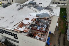
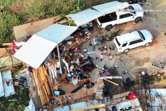
Drone Footage of Tornado Damage at Dothan Prep Academy
Shot Description
00:00 (14 Clips) Drone Footage of tornado that destroyed Dothan Prep Academy while children were in school.
02:29 (2 Clips) Damage of metal shed destroyed from Tornado in Dothan
SID: Michael Gordon
#Dothan #alwx #Tornado #school #weather
To help support our freelancers, buy them coffee. https://www.buymeacoffee.com/stormchasing/
To License This Footage For Broadcast, Contact Video @ StormChasingVideo.com
Our Team Merch Store – https://stormchasingvideo.creator-spring.com
Severe storms with hail, high winds and dangerous cloud to ground lightning made an earlier then normal appearance this spring just south of the Twin Cities metro area. Video shot in the areas just south of the Twin Cities metro in Dakota County.
Shot Description
00:01 – Driving in large hail on Interstate 35.
00:54 – Various clips of lightning
SID: Melanie Metz
#MNWX #severestorms #hail #lightning #weather #stormchasing
To help support our freelancers, buy them coffee. https://www.buymeacoffee.com/stormchasing/
To License This Footage For Broadcast, Contact Video @ StormChasingVideo.com
Our Team Merch Store – https://stormchasingvideo.creator-spring.com
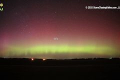
A G2-class geomagnetic storm caused the Auroras to dance in the sky on the evening of the 21st.
The show was well underway as the sun was setting. Once it turned dark, the Auroras filled the northern sky with color. The show was pretty much null by 11:30 pm. This timelapse will show the Auroras going strong and then fading away.
Shot Description
Clips 1-2. Timelapse of the Auroras.
SID: Dirk Miller
#auroraborealis #spaceweather #northernlights
To help support our freelancers, buy them coffee. https://www.buymeacoffee.com/stormchasing/
To License This Footage For Broadcast, Contact Video @ StormChasingVideo.com
Our Team Merch Store – https://stormchasingvideo.creator-spring.com
Severe storms worked through Central Illinois on Wednesday afternoon, causing straight-line wind damage and blowing over semi trucks along I-39. The following video includes clips of a blown-over semi, strong winds, and heavy rain, as well as a video of the severe warned storms rolling into the region.
Shot Description
00:00 Video driving by a blown-over semi on northbound I-39 with several Illinois State Patro cars and emergency personnel at the scene.
00:32 Side video passing by the scene of the blown-over semi-truck with emergency vehicles and police at the scene.
00:43 Wide and medium shots of heavy rain and strong wind gusts as the strong to severe storms worked through the region Wednesday afternoon.
01:08 Three wide-shot clips of the strong to severe storms rolling into Central Illinois. The gusty conditions kicked up dust ahead of the storms visible in the background.
SID: Charlie Bourdo
#ILWX #weather #stormchasing #trucking
To help support our freelancers, buy them coffee. https://www.buymeacoffee.com/stormchasing/
To License This Footage For Broadcast, Contact Video @ StormChasingVideo.com
Our Team Merch Store – https://stormchasingvideo.creator-spring.com
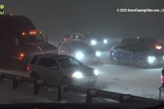
An intense blizzard makes I-25 impassible on March 18, 2025 on Monument Hill, near Monument, Colo. Motorists were stranded as semis jackknifed and blocked the freeway.
Shot Description
00:00 – Tight shot of stuck vehicles in intense wind driven snow on I-25 in Monument Colorado
00:08 – Medium shot of stuck vehicles and semis in intense wind driven snow on I-25 in Monument Colorado.
00:16 – Stranded vehicles and semis in wind driven snow on freeways.
00:21 – Vehicle enters an intersection with blowing snow and zero visibility.
00:30 – Dash video following a car with wind driven snow and visibility less than windshield.
01:34 – Mid shot of CDOT worker directing traffic to make room for recovery vehicles in wind-driven snow.
01:45 – Tight shot of CDOT worker directs traffic to make room for recovery vehicles in wind driven snow.
01:55 – Wide of stuck traffic on I-25 near Monument, Colo. with extremely intense wind driven snow.
02:03 – Mid shot of stuck vans on I-25.
02:11 – Wide shot of stuck vans on I-25.
02:18 – CDOT snowplow finds an opening to advance through the bumper-to-bumper stalled traffic on I-25.
02:38 – Wide of wind driven snow and stalled semi.
02:46 – CDOT recovery vehicle pulls semi up Monument Hill, I-25.
02:58 – Low visibility and stranded vehicles on I-25.
03:05 – Tighter shot of low visibility and stranded vehicles on I-25.
03:15 – Stuck sedan with passengers trying to push it free on I-25.
03:30 – Wide shot including semi of passengers of sedan trying to push vehicle free on I-25.
03:39 – Semi spinning tires on freeway.
03:47 – Numerous semis stuck on freeway.
03:54 – Passenger of semi braves extreme wind driven snow.
04:24 – Tight of stuck semi on roundabout in extreme wind driven snow.
04:34 – Wide of stuck semi on roundabout in extreme wind driven snow.
04:40 – Chaotic arrangement of stranded vehicles on I-25.
04:48 – Tight of stranded vehicles on I-25 in wind driven snow.
04:58 – Semis at a standstill on I-25 in wind driven snow.
SID: Trevor Cokley
#blizzard #colorado #weatherevents #weather
To help support our freelancers, buy them coffee. https://www.buymeacoffee.com/stormchasing/
To License This Footage For Broadcast, Contact Video @ StormChasingVideo.com
Our Team Merch Store – https://stormchasingvideo.creator-spring.com
Troy, AL Tornado Aftermath Drone
00:00 Flyover of a home with the roof ripped off and debris scattered everywhere from Tornado in Troy, AL
00:41 (2 Clips) Troy Sportsplex Gymnasium roof ripped off from tornado
00:56 (3 Clips) Troy Sportsplex Baseball fields and Miracle League field damaged from tornado
01:21 (2 Clips) Roof damage on commercial building
01:41 Gas Station destroyed from tornado and roof ripped off building in Troy, AL
01:56 (3 Clips) Wrecker crews working on flipping over semi tipped in Tornado in Walmart parking lot Troy, Alabama
03:12 Homes Damaged just north of Troy, AL on Elm Street
05:10 Multiple Clips of Troy Fire Department working on clearing trees from residences on Elm Street in Troy, AL
#Troy #alabanzas #drone #alwx #tornado #aftermath
To help support our freelancers, buy them coffee. https://www.buymeacoffee.com/stormchasing/
To License This Footage For Broadcast, Contact Video @ StormChasingVideo.com
Our Team Merch Store – https://stormchasingvideo.creator-spring.com
Tornado Strikes Troy Alabama March 15, 2025
Shot Description
00:00 Tornado Strikes Troy Alabama causing major power flashes as sparks are getting sucked up in the tornado
00:39 (2 Clips) Damage at gas station in Troy, AL from Tornado
00:54 (3 Clips) Semi tipped over in Walmart parking lot with woman inside and Troy EMT and Fire Department helping to extricate her
01:25 Power Poles snapped in half from Tornado
01:31 Raw footage immediately after tornado hit gas station with heavy rain
01:40 Driving down US 231 in Troy, AL after tornado damages city with damage and emergency personnel
SID: Michael Gordon
#Tornado #Weather #alwx #aftermath
To help support our freelancers, buy them coffee. https://www.buymeacoffee.com/stormchasing/
To License This Footage For Broadcast, Contact Video @ StormChasingVideo.com
Our Team Merch Store – https://stormchasingvideo.creator-spring.com
Grenada, Mississippi Hit by Large Tornado on March 14, 2025
Shot Description
00:00 (2 Clips) Semi flipped over from tornado on I-55 NB near Grenada, MS with guy climbing out of cab of truck
00:29 (5 Clips) Ground footage of the destruction of the tornado just south of Grenada, MS
01:12 (7 Clips) Drone Footage of the aftermath of the large tornado near Grenada, MS
02:13 Tornado next to highway as I am driving down the road.
SID: Michael Gordon
#tornado #aftermath #MSwx #weather
To help support our freelancers, buy them coffee. https://www.buymeacoffee.com/stormchasing/
To License This Footage For Broadcast, Contact Video @ StormChasingVideo.com
Our Team Merch Store – https://stormchasingvideo.creator-spring.com
The following video, captured in central Missouri, Mexico, shows the aftermath of strong-to-severe storms that came through the region on Friday, March 14, 2025. It shows piles of hail up to 5" deep and power outages following the storms.
Shot Description
00:00 Video of the leading edge of the storms working into the city.
00:11 Clip of hail sitting on the ground outside a Domino's in Mexico, Missouri.
00:21 Video of a large pile of hail left over from the storms sitting in the middle of the parking lot for a Family Video in town.
00:32 Close-up clips of the hail that had fallen from the storms.
00:49 Various clips shot close and medium, of the hail piled up with a ruler in it measuring around 5" piles of hail.
01:40 Various clips of the power outage at a Casey's Gas Station following the strong-to-severe storms.
02:15 Here are a couple of clips of the lights and power completely out at an intersection in Mexico, MO.
SID: Sara Bruce
#hail #hailstorm #MOWX #weather
To help support our freelancers, buy them coffee. https://www.buymeacoffee.com/stormchasing/
To License This Footage For Broadcast, Contact Video @ StormChasingVideo.com
Our Team Merch Store – https://stormchasingvideo.creator-spring.com
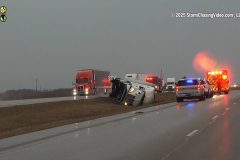
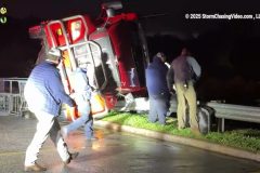
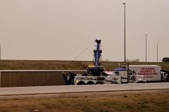
Video from Yukon, Oklahoma, of two semi trucks blown over from the strong winds along I-40 near Garth Brooks Blvd at around 5 PM on Friday, March 14, 2025. Max wind gusts in the area ranged around 60-70 MPH.
Shot Description
00:00 Two wide-angle shots of two semi trucks blown over on I-40 with two larger wreckers working to right them.
00:20 Medium shot video of a truck blown over from I-40 and down the embankment with two large wreckers trying to right it.
00:31 A medium-to-close-shot panning video of the semi truck blown over with two large wreckers and the Oklahoma Hazmat and Remediation truck on scene working on the truck then pans to another semi blown over in the distance on the side of the road along I-40 with another tow truck.
01:02 Video of a large wrecker dragging a blown over semi off the I-40 bridge.
01:16 Closer shot of the large wrecker dragging the truck off the I-40 bridge.
SID: Bradley Patton
#OKWX #extremewinds #highwinds #trucking
To help support our freelancers, buy them coffee. https://www.buymeacoffee.com/stormchasing/
To License This Footage For Broadcast, Contact Video @ StormChasingVideo.com
Our Team Merch Store – https://stormchasingvideo.creator-spring.com
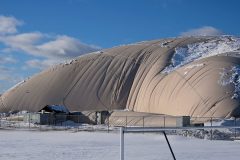
Around 10-12 inches of heavy wet snow fell across parts of the southern Twin Cities Metro. That heavy wet snow partially collapsed the Irish Sports Dome at Rosemount High School in Rosemount, Minnesota, on Wednesday, March 5, 2025.
Shot Description
00:00 Two wide shots of the east side of the sports dome show a partially collapsed dome with snow on top of it.
00:16 Two medium shots of the east side of the dome, showing the dome partially collapsed around a doorway with snow sitting on the deflated dome section.
00:31 Two clips from the side of the collapsed dome.
SID: Will Wight
#MNWX
To help support our freelancers, buy them coffee. https://www.buymeacoffee.com/stormchasing/
To License This Footage For Broadcast, Contact Video @ StormChasingVideo.com
Our Team Merch Store – https://stormchasingvideo.creator-spring.com