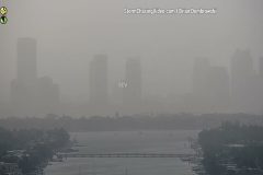
Brutally cold weather is moving back into the Midsection of the nation today, with the morning low temperatures in the negative teens. Local area schools kept kids inside for recess, and virtually nobody was walking around the streets due to the extreme cold wind chills. As of Noon, the air temperature was zero, and the Wind Chill was -13°F in Saint Cloud, MN.
Shot Description
00:00 – Digital sign with the air temp displaying -15F.
08:00 – Digital sign with the date at sunrise displaying -11F.
00:18 – Digital sign at Saint Cloud Tech College showing it was -13F.
00:30 – Someone walking in downtown Saint Cloud while covering their face from the brutal cold air.
00:43 – Drone video over Lake George with the city skyline behind it as crews removed snow from the lake to make an ice rink for skaters.
00:53 – Drone following a large snow blower on Lake George that was being used to remove the snow to make a large skating rink.
01:05 – Two clips of the equipment clearing the snow from the lake.
01:38 – Traffic on Highway 23.
To help support our freelancers, buy them coffee. https://www.buymeacoffee.com/stormchasing/
To License This Footage For Broadcast, Contact Video @ StormChasingVideo.com
Our Team Merch Store – https://stormchasingvideo.creator-spring.com
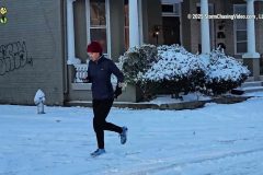
Snow scenes in the historic Fan District of Richmond, Virginia. Drone video of snow Richmond, including a fly-by of the Virginia World War Memorial Carillon and James River.
Shot Description
A person walking a dog on a snowy sidewalk
Dogs
Group of friends with their dogs
Walking along the sidewalk
A car being driven down snowy street
Walking dog on a snowy sidewalk
Runner on a snowy street
Runner on a snowy street
Drone flyby of The Virginia World War Memorial Carillon
Houses along the James River
James River and Railroad Bridge
SID: William Hark
#VAWX #Winter Snow
To help support our freelancers, buy them coffee. https://www.buymeacoffee.com/stormchasing/
To License This Footage For Broadcast, Contact Video @ StormChasingVideo.com
Our Team Merch Store – https://stormchasingvideo.creator-spring.com
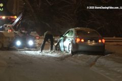
Multiple accidents around Cincinnati, Ohio, during a major winter storm hitting the Midwest and Southeast.
All footage was shot during evening darkness on January 10, 2025, in/near Cincinnati, Ohio, by Meteorologist and Storm Chaser Simon Brewer.
Shot Description
00:00 Tractor trailer stranded in the median of Interstate after sliding off the snow-covered highway.
00:21 Vehicle wrecked and turned around on Interstate Highway with the driver searching for pieces of his truck.
00:47 Multiple vehicles were wrecked and in ditches with emergency assistance.
01:50 Snowplows clearing roadways.
02:12 Traffic in heavy snow.
SID: Simon Brewer
#ohwx #weather #snowstorm
To help support our freelancers, buy them coffee. https://www.buymeacoffee.com/stormchasing/
To License This Footage For Broadcast, Contact Video @ StormChasingVideo.com
Our Team Merch Store – https://stormchasingvideo.creator-spring.com
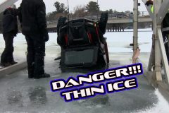
This video package will show UTV (Utility Task Vehicle) ice recovery that took place today on January 10th, 2025. The cold weather we have been having has allowed the recovery to happen. Ice conditions were not safe enough after the UTV went through the ice. The UTV was sitting in about 12 feet of water. The information below is the press release from the Barron County Sheriff's Office on said UTV.
Press Release
December 26, 2025
On Wednesday, December 25, 2024, at 6:54 p.m., the Barron County Sheriff’ Department 911 center received a call of two people and a UTV that went through the ice near the Pokegama Boat Landing east of Chetek. Deputies from the Barron County Sheriff’s Department along with the Chetek Police Department, Chetek EMS and Chetek Fire Department all responded to the scene.
Upon arrival, both people that were in the water had been helped out of the water by a family that was ice fishing near the area. One male subject, 25 from Chetek, was treated and released at the scene, and the driver of the UTV, a 53-year-old male from Chetek, was transported to LMC with non-life-threatening injuries.
Special thanks to the family that assisted in rescuing these two people and all the responders who left their families on Christmas to help others, as they do each and every day of the year. The Barron County Sheriff’s Department Recreational Division is handling this crash.
With warmer temps this week, please check ice conditions even if you are familiar with the lake.
Per Chris Fitzgerald, Barron County Sheriff
Shot Description
Clip 1. The ice recovery team is getting the ice recovery equipment ready.
Clip 2. The team pulled the ice recovery equipment out to where the UTV is. Onlookers are watching the process from the boat landing.
Clip.3 The team is using an underwater camera to hook up the UTV.
Clip 4. Britt cut the ice back and wider so the UTV could be lifted out of the water.
Clips 5-7. Britt is still cutting the ice back while the team is pushing the ice blocks under the main sheet of ice.
Clips 8-9. The UTV is being pulled up from the lake bottom to the surface.
Clip 10. The UTV is out of the water and is being pulled away from the open water to safer ice.
Clip 11. Onlookers were watching the ice recovery from the bridge. One can also see the pressure ridge.
Clips 12-13. The ice recovery team is putting up red flags to warn people of the open water and weaker ice conditions in that area.
Clip 14. The UTV is being pulled across the lake to the boat landing.
Clips 15-16. Shows how long this pressure ridge is.
SID: Dirk Miller
#icefishing #winter #wiwx
To help support our freelancers, buy them coffee. https://www.buymeacoffee.com/stormchasing/
To License This Footage For Broadcast, Contact Video @ StormChasingVideo.com
Our Team Merch Store – https://stormchasingvideo.creator-spring.com
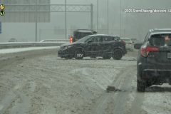
Winter Storm hits the Southeast and Midwest with heavy snow and dangerous driving conditions.
All footage was shot in/near the Bowling Green, Kentucky region on January 10, 2025, by Meteorologist and Storm Chaser Simon Brewer.
Shot Description
00:00 Vehicle accidents from wintry conditions.
00:16 Heavy snow falling with trees.
00:25 Heavy snow falling on Cardinal statue.
00:34 Snowplows clearing Interstate 65 with snow falling.
01:02 Bowling Green highway sign with snow.
01:05 National Corvette Museum with heavy snow falling.
01:25 Western Kentucky University water tower with snow falling.
SID: Simon Brewer
To help support our freelancers, buy them coffee. https://www.buymeacoffee.com/stormchasing/
To License This Footage For Broadcast, Contact Video @ StormChasingVideo.com
Our Team Merch Store – https://stormchasingvideo.creator-spring.com
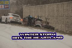
A powerful winter storm brings heavy snow and dangerous driving conditions to Dayton, Ohio, and the Midwest.
All footage was shot by meteorologist and storm chaser Simon Brewer in/near Dayton, Ohio, on the evening and night of January 5, 2025.
Shot Description
00:00 accident involving multiple vehicles on I-75
00:45 tractor-trailer in snow
01:02 Multiple accidents on the highway
01:47 A person clears snow off the vehicle with heavy snow falling
02:13 Front loader clearing snow from the parking lot
02:35 Neighborhood and cars buried under deep snow
03:25 Winter Storm Warning electronic highway sign
03:36 snowplows clearing roads
SID: Simon Brewer
#winterstorm #ohwx #snowstorm
To help support our freelancers, buy them coffee. https://www.buymeacoffee.com/stormchasing/
To License This Footage For Broadcast, Contact Video @ StormChasingVideo.com
Our Team Merch Store – https://stormchasingvideo.creator-spring.com
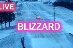
See hazardous winter weather impacting highways live. Blizzard conditions with ice and snow closing roadways around Kansas City MO. Multiple semi-trucks and vehicles stranded on roadways. Live cameras and public safety radio of I-70, I-435 and other roads. January 2025.
#mowx
#weather
#blizzard
Multiple accidents and stranded vehicles as a powerful winter storm begins in Cincinnati, Ohio.
All footage was shot during morning daylight on January 5, 2025, in/near Cincinnati, Ohio, by Meteorologist and Storm Chaser Simon Brewer
Shot Description
00:00 Multiple accidents and stranded vehicles on Interstate 75 in Cincinnati, Ohio.
00:51 Snowplows clearing snow and spreading salt solution.
01:19 traffic with snow falling on I-75.
01:34 Man using leaf blower to clear snow from Downtown Cincinnati sidewalk.
01:43 Pedestrians walking in snow in Downtown Cincinnati.
01:58 Man using a broom to clear snow off his vehicle.
02:26 snow falling among skyscrapers in downtown Cincinnati.
02:46 Traffic and snow-covered I-75.
03:06 Cincinnati Highway sign.
03:13 Winter Storm Warning on an electronic highway sign.
03:25 Famous Traders World billboard in Cincinnati.
03:38 Cincinnati Metro landmark statue.
SID: Simon Brewer
#OHWX #winterstorm #snowstorm #weather
To help support our freelancers, buy them coffee. https://www.buymeacoffee.com/stormchasing/
To License This Footage For Broadcast, Contact Video @ StormChasingVideo.com
Our Team Merch Store – https://stormchasingvideo.creator-spring.com
Ahead of what is forecasted to be an impactful winter storm for Missouri, local stores across parts of central Missouri reportedly had empty or close to empty shelves as people stocked up before the storm. The following video was captured from the Aldi and Walmart in Mexico, Missouri, showing several empty store shelves and a low stock of food and drinks ahead of the winter storm.
Shot Description
00:00 Shot of the outside of the local Aldi store in Mexico, Missouri.
00:08 Various clips of empty store shelves inside the Aldi store with people in the background attempting to get last-minute items before the winter storm arrived.
00:30 A shot of a section of water bottles is completely gone.
00:38 Shot of the outside of the Walmart store in Mexico, Missouri, showing a full parking lot as people prep ahead of the winter storm.
00:46 Various shots of the drinks section inside the Walmart with large sections of empty shelves and two sections of no water bottles as people have bought all the goods ahead of the winter storm.
01:15 Two clips of a worker restocking the eggs section in the Walmart as the eggs were completely sold out ahead of the winter storm. The second shot has patrons walking by and looking at the empty eggs section.
01:37 A shot of the milk section showing large portions of missing milk or a low milk stock ahead of the winter storm.
01:44 A few videos of the bread section show only a handful of buns and bread left on the shelf as people bought up all the bread ahead of the winter storm. One clip has people in the aisle getting last-minute items.
02:09 A couple of shots from the meat section of Walmart show the meat supply was also very low ahead of the winter storm.
02:28 A couple of shots from the soup aisle show a very low stock of canned soup left ahead of the winter storm.
02:54 Video of the produce section in Walmart with completely bare shelves ahead of the winter storm.
03:06 Another video of the fresh bread section with only a couple of bread items remaining.
03:14 A couple of videos from the frozen food/pizza aisle show only a few pizzas left, mostly the aisle with low supply ahead of the winter storm.
03:32 Video of the toilet paper remaining ahead of the winter storm.
03:53 A few clips of the only salt remaining ahead of the winter storm.
04:23 A clip of people checking out at Walmart.
SID: Sara Bruce
#Winterstorm #MOWX #Blizzard
To help support our freelancers, buy them coffee. https://www.buymeacoffee.com/stormchasing/
To License This Footage For Broadcast, Contact Video @ StormChasingVideo.com
Our Team Merch Store – https://stormchasingvideo.creator-spring.com
See hazardous winter weather impacting Kansas City Missouri area highways live. Live cameras and public safety radio of the I-70 and other areas around Kansas & Missouri due to the blizzard/winter storm. January 4 202. Kansas City MO.
#mowx
#weather
#blizzard
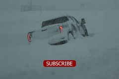
Several feet of heavy lake effect snow causes multiple accidents and buried Watertown, New York.
All footage shot during morning daylight in/near Watertown, NY on December 1,2024 by meteorologist and Storm Chaser Simon Brewer
Shot Description
00:00 multiple vehicles wrecked and stranded in deep snow after sliding of Interstate 81 in Watertown, New York
01:31 near whiteout conditions as heavy snow falls on traffic on I-81 in Watertown
01:55 locals deal with heavy snow and buried neighborhoods in Watertown
02:47 cars and neighborhoods buried under several feet of snow in Watertown
03:22 electronic time and temperature sign in Watertown
03:28 electronic highway sign with "Lake Effect Snow Warning"
03:37 heavy snow and traffic on I-81 in Watertown
SID: Simon Brewer
To help support our freelancers, buy them coffee. https://www.buymeacoffee.com/stormchasing/
To License This Footage For Broadcast, Contact Video @ StormChasingVideo.com
Our Team Merch Store – https://stormchasingvideo.creator-spring.com
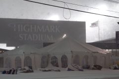
Multiple wrecked vehicles from heavy lake effect snow on Interstate 90 in Orchard Park, New York. Heavy snow falling on Highmark Stadium, Home of the Buffalo Bills NFL Team, which plays a game Sunday in the snow-filled stadium.
All footage shot during evening darkness on November 30, 2024 in/near Orchard Park, NY by Meteorologist and Storm Chaser Simon Brewer
Shot Description
00:00 tractor trailor in ditch after sliding off I-90 from deep snow with EMS assistance
00:47 people digging out from heavy snow
01:05 heavy snow falls over Highmark Stadium, Home of the Buffalo Bills NFL Team
01:35 various snow plows clears streets, highways, and parking lots
02:39 heavy snow falling next to large snowflake decorations
02:54 traffic in heavy snow
03:04 snowplow clearing I-90
03:24 traffic in low visibility heavy snow on I-90
SID: Simon Brewer
To help support our freelancers, buy them coffee. https://www.buymeacoffee.com/stormchasing/
To License This Footage For Broadcast, Contact Video @ StormChasingVideo.com
Our Team Merch Store – https://stormchasingvideo.creator-spring.com
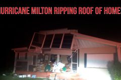
Hurricane Milton storm surge flooding neighborhood, high winds damage homes and flip plane, close power flash as the storm made landfall.
All footage shot during evening darkness on October 9, 2024 in Venice, Florida by Meteorologists and Storm Chasers Juston Drake and Simon Brewer.
Shot Description
00:00 front of home ripped off by high winds
00:12 roof hits vehicle and camera person
00:27 power lines explode over vehicle
00:35 roof destroyed from home
00:45 storm surge floods neighborhood and debris in air
01:00 plane flipped over onto fence by high winds at Venice Airport
01:10 storm surge floods Venice
02:39 trees and damage from high winds
02:58 furniture and debris from homes scattered in road from storm surge
SID: Simon Brewer Juston Drake
#hurricane #Milton #hurricanemilton #flwx #stormsurge
To help support our freelancers, buy them coffee. https://www.buymeacoffee.com/stormchasing/
To License This Footage For Broadcast, Contact Video @ StormChasingVideo.com
Our Team Merch Store – https://stormchasingvideo.creator-spring.com
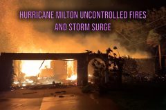
Hurricane Milton causes massive house fire and devastating storm surge near Venice, Florida
Shot Description
00:00 (2 Clips) Hurricane Milton causes house fire and burns to the ground near Venice, FL
00:35 (2 Clips) Pelican Alley Boat Storage destroyed by Hurricane Milton
00:54 Storm Surge Floods roadway near Casey Key, FL
01:03 Roof destroyed from extreme winds from Hurricane Milton
01:12 Business sunk in feet of storm surge from Hurricane Milton
01:21 Multiple Clips showing devastating storm surge from Hurricane Milton around Venice, Florida area
SID: Michael Gordon
#hurricanewarning #hurricanemilton #flwx #stormsurge
To help support our freelancers, buy them coffee. https://www.buymeacoffee.com/stormchasing/
To License This Footage For Broadcast, Contact Video @ StormChasingVideo.com
Our Team Merch Store – https://stormchasingvideo.creator-spring.com
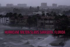
Hurricane Milton makes landfall in Sarasota bringing extreme winds, heavy damage and major storm surge to the area.
Shot Description
0:00- Hurricane Force winds cause power flashes and palm trees to go down on Tamiama Road in Sarasota, FL.
0:15- A dumpster floats in deep storm surge as power flashes fill the night sky in Sarasota, FL.
0:32- Various shots of extreme winds and storm surge as Hurricane Milton makes landfall in Sarasota, FL.
1:18- Power transformers exploded behind the Sarasota skyline
1:44- View, from the Ringling Causeway Bridge of hurricane force winds battering Siesta Key, FL.
2:27- In The Eye; Various shots of storm surge flooding at the Sarasota Bay Marina.
2:54- Various shots of storm surge flooding from around Sarasota, FL.
SID: Scott McPartland
#flwx #hurricanemilton #hurricanewarning #stormsurge
To help support our freelancers, buy them coffee. https://www.buymeacoffee.com/stormchasing/
To License This Footage For Broadcast, Contact Video @ StormChasingVideo.com
Our Team Merch Store – https://stormchasingvideo.creator-spring.com
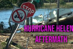
Search and rescue coast guard helicopter, scoured asphalt in with destroyed home damage over road, heavy damage to Steinhatchee from storm surge. Widespread tree and utility line damage.
All footage shot during morning daylight on September 27, 2024 by Meteorologists and Storm Chasers Juston Drake and Simon Brewer.
Shot Description
00:00 Coast Guard Helicopter performing search and rescue operations over Steinhatchee, FL
00:28 piles of debris and damage in Steinhatchee neighborhood after storm surge receded
01:54 widespread heavy tree damage in Steinhatchee, FL
SID: Simon Brewer Juston Drake
#hurricanehelene #hurricane #aftermath #flwx
To help support our freelancers, buy them coffee. https://www.buymeacoffee.com/stormchasing/
To License This Footage For Broadcast, Contact Video @ StormChasingVideo.com
Our Team Merch Store – https://stormchasingvideo.creator-spring.com
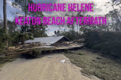
Drone Footage of Keaton Beach, FL from Hurricane Helene | Total Devastation of most of the area.
Shot Description
Multiple Drone Clips showing the catastrophic damage from Hurricane Helene around Keaton Beach and Cedar Island, FL.
SID: Michael Gordon
#Hurricanehelene #keatonbeach #drone #flwx #aftermath
To help support our freelancers, buy them coffee. https://www.buymeacoffee.com/stormchasing/
To License This Footage For Broadcast, Contact Video @ StormChasingVideo.com
Our Team Merch Store – https://stormchasingvideo.creator-spring.com
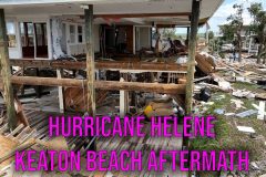
Drone and Ground Footage of Keaton Beach, FL after Hurricane Helene
Shot Description
00:00 (6 Clips) Drone footage of Keaton Beach, FL
01:13 (4 Clips) Ground Footage of homes swept off their foundation
01:46 Me standing on top of this roof with the owner of the home in Keaton Beach
01:56 Chinook helicopter flying around Keaton Beach with homes swept off their foundation
2:05 Driving in to Keaton Beach showing the damage
SID: Michael Gordon
#aftermath #keatonbeach #hurricanehelene #FLWX
To help support our freelancers, buy them coffee. https://www.buymeacoffee.com/stormchasing/
To License This Footage For Broadcast, Contact Video @ StormChasingVideo.com
Our Team Merch Store – https://stormchasingvideo.creator-spring.com
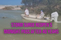
The controversial "Midnight Pass" in Siesta Key, Florida that was closed off for over 40 year's and has been undergoing several environmental studies to reopen it, was reopened by Hurricane Helene.
Shot Description
Three raw clips of Midnight Pass reopened by Hurricane Helene where it was once a beach is now a six foot (2 meter) deep channel to the Gulf Of Mexico.
SID: Brian Dombrowski
#HurricaneHelene #midnightpass #siestakey #FLWX
To help support our freelancers, buy them coffee. https://www.buymeacoffee.com/stormchasing/
To License This Footage For Broadcast, Contact Video @ StormChasingVideo.com
Our Team Merch Store – https://stormchasingvideo.creator-spring.com
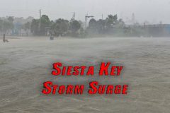
Storm surge and massive waves from Hurricane Helene pound beach house and cross over Siesta Key at Midnight Pass beach. Hi winds and surge at intracoastal waterway in Nokomis FL.
Shot Description
00:00 Wave crashed into house at Midnight Pass Beach Siesta Key FL.
00:10 Storm surge races past Gulf of Mexico beach front house into road and into Little Sarasota Bay. Surge as officially crossed Siesta Key, a barrier island in Sarasota Co.
00:40 More storm surge running from Gulf past house and downslope towards bay.
00:51 Winds blast the intracoastal waterway as surge rolls into the bay. Nokomis FL.
01:03 Surge rushing into channel with wind driven waves at marine navigation sign at Albee brdige.
01:10 More winds and surge on the intracoastal waterway.
01:20 Heavy rain and wind and dock submerged from surge.
SID: Brian Dombrowski
#hurricanewarning #FLWX #hurricanehelene #florida
To help support our freelancers, buy them coffee. https://www.buymeacoffee.com/stormchasing/
To License This Footage For Broadcast, Contact Video @ StormChasingVideo.com
Our Team Merch Store – https://stormchasingvideo.creator-spring.com
Outer rain bands from developing Tropical Storm Debby reached south Florida this afternoon from Key West to Miami Florida. Video shows ominous squally rain bands approaching then enveloping Key West and Port Miami. Possible funnel cloud at Pigeon Key near Marathon FL. Includes a time-lapse showing squalls coming into Key West FL.
Shot Description
00:00 Rain band squall overcoming Port Miami.
00:10 Rain band squall approaching Key West.
00:23 Heavy rain obscuring cruise ship at Port Miami.
00:32 Heavy rain obscuring cruise ship at Port Miami, close.
00:41 Heavy rain at MacArthur Causeway Miami Florida.
00:54 Rain obscures Miami South Beach skyline, wide.
01:05 Rain obscures Miami South Beach skyline, close.
01:13 Heavy rain hitting Port Miami with cruise ships.
01:21 Squall with cloud lowering near Pigeon Key Marathon FL.
01:31 Tight shot of cloud lowering potential funnel cloud.
01:42 Wind and choppy seas at Seven Mile Bridge Marathon FL.
01:51 Rain band approaching Sunset Key near Key West FL.
02:00 Time-lapse showing squall coming into Mallory Square at Key West FL.
SID: Brian Dombrowski
#TropicalStorm #TropicalStormDebby #FLWX
To help support our freelancers, buy them coffee. https://www.buymeacoffee.com/stormchasing/
To License This Footage For Broadcast, Contact Video @ StormChasingVideo.com
Our Team Merch Store – https://stormchasingvideo.creator-spring.com
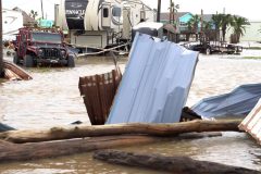
Fire rescue boat races to help, road scoured by storm surge, homes damaged from Hurricane Beryl in Sargent and Sargent Beach, Texas.
All footage shot in Sargent and Sargent Beach, Texas on July 8, 2024 by Meteorologist and Storm Chaser Simon Brewer
Shot Description
00:00 dogs on porch of damaged house surrounded by flood water
00:21 flipped RV from high winds
00:28 homes damaged from high winds
00:40 pelican seeking refuge from high winds
00:51 fire rescue boat races to help stranded homeowners from storm surge
01:02 utility vehicles avoid fallen tree over highway to fix utility lines
01:13 front loader clears highway with debris from storm surge
01:31 flooded neighborhood
02:19 shot from causeway of Sargent, Texas under flood water
02:52 roadway scoured by storm surge in Sargent Beach
SID: Simon Brewer
#hurricaneberyl #texas #txwx #hurricanechasing
To help support our freelancers, buy them coffee. https://www.buymeacoffee.com/stormchasing/
To License This Footage For Broadcast, Contact Video @ StormChasingVideo.com
Our Team Merch Store – https://stormchasingvideo.creator-spring.com
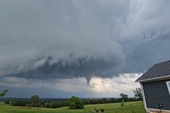
Tornado crossing the road, then through a farm, Multiple vortices in Bendavis, MO.
Shot Description
Clip 1: Tornado crossing the road with flying debris.
Clip 2: Moving through a farm.
Clip 3: Closeup of tornado.
Clip 4: Wide angle view of tornado and storm.
Clip 5: Another closeup of the tornado.
SID: William Hark
To help support our freelancers, buy them coffee. https://www.buymeacoffee.com/stormchasing/
To License This Footage For Broadcast, Contact Video @ StormChasingVideo.com
Our Team Merch Store – https://stormchasingvideo.creator-spring.com
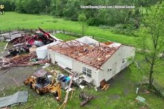
First Light Tornado Aftermath In Henagar, Alabama
Shot Description
10 Clips showing extensive home damage from Tornado in Henagar, Alabama in DeKalb County.
SID: Michael Gordon
#Aftermath #Drone #Tornado #alwx
To help support our freelancers, buy them coffee. https://www.buymeacoffee.com/stormchasing/
To License This Footage For Broadcast, Contact Video @ StormChasingVideo.com
Our Team Merch Store – https://stormchasingvideo.creator-spring.com