Close Lightning Strikes while driving under Tornado Warned Storm in Texas
April 28th, 2023
Simon Brewer & Juston Drake
Purmela, TX
#shorts #lightning #caution #weather #driving #storm #stormchasing #supercell #april #2023
To help support our freelancers, buy them coffee. https://www.buymeacoffee.com/stormchasing/
To License This Footage For Broadcast, Contact Video @ StormChasingVideo.com
Our Team Merch Store – https://stormchasingvideo.creator-spring.com
To help support our freelancers, buy them coffee. https://www.buymeacoffee.com/stormchasing/
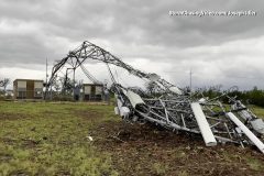
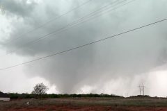
Damage video from tornado touchdown in fort hood TX. Cell phone tower twisted, power polls down and trees snapped also video of storm approaching.
Shot Description
00:00 – cell tower down
00:12 – shot of base entrance
00:37 – Building roof blown off
00:49 – Building collapse
01:00 – radio tower down
01:14 – power lines down
01:27 – cell view of cell tower behind
01:40 – utility company arrives on scene
01:53 – fallen tree blocking road
02:04 – storm approaching
02:24 – up close shot of the storm
SID: Joseph Idler
#Texas #tornado #stormchasing #stormdamage
To License This Footage For Broadcast, Contact Video @ StormChasingVideo.com
Our Team Merch Store – https://stormchasingvideo.creator-spring.com
To help support our freelancers, buy them coffee. https://www.buymeacoffee.com/stormchasing/
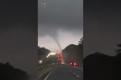
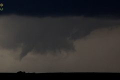
Severe hail, hail fog, dramatic lightning, and tornadic supercell thunderstorm near Purmela and Mt. Calm Texas on another day of extreme storms.
All footage shot in/near Purmela and Mt. Calm, TX during evening daylight on April 28, 2023 by Meteorologists Juston Drake and Simon Brewer
Shot Description
00:00 large hail rips leaves from trees, covers road, and pounds storm chasers
01:00 deep hail accumulation over home and yard
01:14 storm chasers pick up piles of hail covering road
01:44 hail fog and hail-covered road
02:11 massive rotating wall cloud over Purmela, TX
03:16 severe hail storm near Mt. Calm, TX
03:30 dramatic lightning over Purmela, TX
SID: Simon Brewer Juston Drake
#TXWX #Hail #stormchasing #weather #tornadoalley
To License This Footage For Broadcast, Contact Video @ StormChasingVideo.com
Our Team Merch Store – https://stormchasingvideo.creator-spring.com
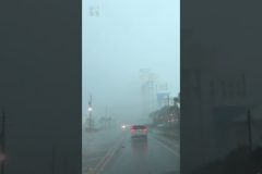
Huge hail storm whiteout causes danger for cars in Florida – April 26th 2023
Melborne, Florida
SID: Chris Collura
#shorts #hail #hailstorm #whiteout #dangerous #cars #driving #storm #april #2023 #weather #thursday
To help support our freelancers, buy them coffee. https://www.buymeacoffee.com/stormchasing/
To License This Footage For Broadcast, Contact Video @ StormChasingVideo.com
Our Team Merch Store – https://stormchasingvideo.creator-spring.com
Driver Caught in Waterspout Tornado with flying debris today in Florida! April 27th 2023
Panama City Beach, Florida
SID: Michael Gordon
#shorts #tornado #thursday #waterspout #florida #panamacitybeach #weather #april #2023 #storm #driver #cars #breakingnews
To help support our freelancers, buy them coffee. https://www.buymeacoffee.com/stormchasing/
To License This Footage For Broadcast, Contact Video @ StormChasingVideo.com
Our Team Merch Store – https://stormchasingvideo.creator-spring.com
Massive Hail storm and Tornadic Supercell in Texas this week
April 26th, 2023
Waco, Texas
SID: Simon Brewer and Juston Drake
#shorts #tornado #supercell #storm #hail #hailstorm #weather #april #2023 #texas
To help support our freelancers, buy them coffee. https://www.buymeacoffee.com/stormchasing/
To License This Footage For Broadcast, Contact Video @ StormChasingVideo.com
Our Team Merch Store – https://stormchasingvideo.creator-spring.com
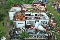
Drone video of the aftermath of the tornado that hit the town of Hosford, Florida.
Vivid footage of the tornado destruction showing snapped off tree’s and homes damaged and destroyed with debris thrown all over the place.
Shot Description
00:00 – Destroyed home, looking down at the debris of what is left of a home with no roof.
00:21 – Following the damage path of the tornado.
00:32 – Looking down at another damaged home with a partial roof removal.
00:39 – Flying over several damaged homes and debris scattered everywhere.
00:59 – Several Wide shot of homes damaged.
01:16 – Flyover of the damage to multiple homes damaged showing snapped off trees.
SID: Michael Gordon
#stormchasing #stormdamage #dronevideo
To help support our freelancers, buy them coffee. https://www.buymeacoffee.com/stormchasing/
To License This Footage For Broadcast, Contact Video @ StormChasingVideo.com
Our Team Merch Store – https://stormchasingvideo.creator-spring.com
Multi-vortex Tornado threatens Waco, Texas – April 26th 2023
SID: Simon Brewer and Juston Drake
#shorts #tornado #storm #stormchasing #texas #thursday #april #2023
To help support our freelancers, buy them coffee. https://www.buymeacoffee.com/stormchasing/
To License This Footage For Broadcast, Contact Video @ StormChasingVideo.com
Our Team Merch Store – https://stormchasingvideo.creator-spring.com
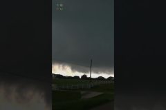
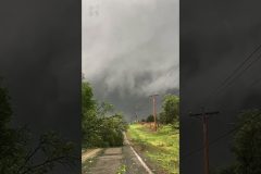
Cone-shaped multivortex tornado forms near Waco, TX from a severe supercell thunderstorm with damaging large hail and high winds.
All footage shot in/near Waco, TX during evening daylight on April 26, 2023 by meteorologists Juston Drake and Simon Brewer
Shot Description
00:00 cone tornado develops near Waco, TX
00:34 multivortex tornado behind storm chasers on highway
00:54 bowl-shaped funnel cloud, multivortex tornado with rotating rain curtains
01:31 bowl funnel cloud under large rapidly rotating wall cloud
01:39 large wall cloud behind downtown Waco, TX
01:51 tennis ball and racquetball sized hail
02:16 tree downed over road from tornadic supercell thunderstorm
02:24 rotating wall cloud
02:38 sculpted supercell structure
SID: Simon Brewer Juston Drake
#Tornado #texas #TXWX #weather
To help support our freelancers, buy them coffee. https://www.buymeacoffee.com/stormchasing/
To License This Footage For Broadcast, Contact Video @ StormChasingVideo.com
Our Team Merch Store – https://stormchasingvideo.creator-spring.com
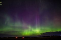
A severe G4-class geomagnetic storm sparked another great Aurora show last evening and well into the early morning hours. No matter what direction one would look, one could see the Auroras. This is a short timelapse of the show.
Shot List:
Clips 1-6. Timelapse of the Auroras.
To help support our freelancers, buy them coffee. https://www.buymeacoffee.com/stormchasing/
To License This Footage For Broadcast, Contact Video @ StormChasingVideo.com
Our Team Merch Store – https://stormchasingvideo.creator-spring.com
Powerful Aurora Solar Storm Overhead Last Night! Northern Lights on Steroids
4/24/23
Sauk Centre, MN
Doug Kiesling
#extreme #solarstorm #storm #northernlights #auroraborealis #aurora #minnesota #night #weather #april #2023
Music licensed on Artlist.io. “Tundra Instrumental Version” by TomasNovoa
To help support our freelancers, buy them coffee. https://www.buymeacoffee.com/stormchasing/
To License This Footage For Broadcast, Contact Video @ StormChasingVideo.com
Our Team Merch Store – https://stormchasingvideo.creator-spring.com
A Severe Geomagnetic Storm rocked the upper atmosphere of the earth overnight and into this morning making for an incredible Northern Lights or Aurora Borealis light show over the northern United States and Canada.
Footage from a multi camera setup near the town of Sauk Centre, Minn, which is located in far western Stearns County. Clips show various scenes of the Northern Lights looking over the horizon and even straight up in the air as they pulsed through the sky and towards the southern Horizon.
Shot Description
00:00 – Wide shot of the Auroras over a field and the moon setting when they explode in the sky.
00:28 – Looking straight up in the sky and the Auroras are pulsating and dancing like something out of a Sci Fi movie.
00:40 – Ultra wide 14MM lens shot of the Aurora filling and cutting through the sky with all kinds of colors.
00:57 – Another clip of the Auroras looking straight up as they put on a memorizing show.
01:29 – Solar wind from the Auroras and a large wind turbine where it looks as if the auroras are spinning the blades.
02:06 – Ultra wide 14MM lens shot of the wind farm and the Auroras.
02:37 – Wind Turbine and Auroras
03:19 – Green arc of the Auroras as they started to fade.
03:43 – 14mm shot of the Aurora with the wind turbine and foreground lighting.
03:53 – Auroras pulsating and filling the sky.
04:15 – Auroras filling the entire wide lens frame while dancing all over the sky.
04:56 – Auroras fading away but still pulsating in the sky.
SID: Doug Kiesling
#auroraborealis #northernlights #MNWX #Auroras
To help support our freelancers, buy them coffee. https://www.buymeacoffee.com/stormchasing/
To License This Footage For Broadcast, Contact Video @ StormChasingVideo.com
Our Team Merch Store – https://stormchasingvideo.creator-spring.com
Tornado Chasers Extreme Intercepts Part 2 – Storm Chasing Video
Compilation
#shorts #tornado #extreme #stormchasing #supercell #weather #spring
To help support our freelancers, buy them coffee. https://www.buymeacoffee.com/stormchasing/
To License This Footage For Broadcast, Contact Video @ StormChasingVideo.com
Our Team Merch Store – https://stormchasingvideo.creator-spring.com
To help support our freelancers, buy them coffee. https://www.buymeacoffee.com/stormchasing/
A mentally unstable man assaults an officer from the NYPD on Broadway & West 30th Street.
Shot Description
0:00- A mentally unstable man on his knees stands up and momentarily confronts a bicyclist, before turning his attention on an NYPD officer. He asks the officer for his radio and all his gear before putting his hands on him and ends up knocking the officers body camera off and onto the cement.
0:45- Two officers from the NYPD taken down and then handcuff the man.
1:51- The mentally unstable man is escorted to a waiting ambulance.
SID: Scott McPartland
#EarthDay #NYC #NewYorkCity #NYPD
To License This Footage For Broadcast, Contact Video @ StormChasingVideo.com
Our Team Merch Store – https://stormchasingvideo.creator-spring.com
To help support our freelancers, buy them coffee. https://www.buymeacoffee.com/stormchasing/
A combination of quick snow melt and a couple of days of heavy rain has resulted in flooding along the Mississippi and Minnesota Rivers across the Twin Cities. The following video has a combination of clips across Bloomington and St Paul, Minnesota of the flooding impacts at Fort Snelling State Park, Crosby Farm Regional Park, Watergate Marina, Old Cedar Avenue Bridge Trailhead, and across parts of downtown St Paul along the river.
Shot Description
00:00 A wide shot of the very high Mississippi River in the foreground and part of the city of St Paul in the background.
07:00 Close up shot of a sign saying “Park Closed” and “Closed Due To High Water” at the entrance of Crosby Farm Regional Park.
00:14 Wide and close shot of a sign saying “Trail Closed Due to High Water” and high water covering the trail in the background as the Mississippi River has claimed the riverfront path along Upper Landing Park in St Paul.
00:24 A close and wide shot of the previously mentioned path completely submerged in water with three ducks swimming in the middle of the flood water/path.
00:34 Clip of the fast-flowing Mississippi River in the foreground with the Clarence W Wigington Pavilion in the background.
00:40 Series of clips from the City House venue that overlooks the Mississippi River. First shot is a wide shot of the side of the City House with the Clarence W Wigington Pavilion in the background. Second shot is a close shot of a scale showing the depth of the water next to the City House.
00:49 Close shot of base support for the Smith Avenue Bridge over the fast-flowing Mississippi River. At the base of the bridge support, you can see trees piling up against the post with a log/tree floating by in the foreground.
00:54 Clip of the side of the City House restaurant as the Mississippi River is just a few inches below the bottom of the building that overhangs the river.
00:59 Close shot of the Harriet Island Regional Park and Pavilion in St Paul, Minnesota completely surrounded by high waters from the Mississippi River that is flowing fast in the foreground.
01:07 A medium and close shot from the other side of the City House of trees and logs getting stuck on one side of the building/structure.
01:17 Video of one of the river boats on the Mississippi River with several logs stuck and piling up in front of the boat.
01:23 Three medium shot clips from the St Paul Downtown Airport where two runways have been closed due to flooding and flood walls were installed. In the three clips, you will see flooding from the Mississippi River begin to encroach on the airport with a flood wall installed. A small private jet is also seen preparing to take off.
01:37 Medium shot from the middle of the Old Cedar Avenue bridge showing the trail becoming submerged in high water from the Minnesota River in the background with the new HWY 77/Cedar Avenue Bridge in the background. with geese and ducks swimming where the trail once was.
01:42 Clip of a sign saying “Trail May Be Flooded. Do Not Enter Flooded Trails”
01:47 Clip of a lady walking toward the flood waters on the Old Cedar Avenue trail with her dog.
01:52 Two clips shot wide and medium of the Old Cedar Avenue Bridge with high waters from the Minnesota River beginning to reach the bottom of the bridge.
02:02 Clip of the Old Cedar Avenue trail submerged in high water from the Minnesota River with geese and ducks swimming where the trail once was.
02:08 A couple clips of the boardwalk completely underwater from the Minnesota River overflowing its banks into the nearby marsh area.
02:16 A close and medium shot of a large boat on stilts surrounded by water from the Mississippi River as it over flows its banks. The Mississippi River can be seen flowing fast in the background.
02:29 Medium and close shots of the boat on stilts and the rest of the marina being swallowed by the rising flood waters of the Mississippi River.
02:36 A close shot of a guy standing in a row boat and paddling to the docks in the middle of the marine that has become an island from the rising flood waters.
02:45 A close shot of the rushing Mississippi River in the background and the far end of the marina under several feet of water in the foreground.
SID: Will Wight
#MNWX #Flooding #mississippiriver #Minnesotariver
To License This Footage For Broadcast, Contact Video @ StormChasingVideo.com
Our Team Merch Store – https://stormchasingvideo.creator-spring.com
Large Tornado moving into Cole, Oklahoma yesterday #shorts
4/19/23
SID: Brandon Sullivan
#tornado #storm #oklahoma #weather #spring #april #2023
To help support our freelancers, buy them coffee. https://www.buymeacoffee.com/stormchasing/
To License This Footage For Broadcast, Contact Video @ StormChasingVideo.com
Our Team Merch Store – https://stormchasingvideo.creator-spring.com
Deadly Tornado hits Cole Oklahoma Yesterday – Close Range View
4/19/23
SID: Edgar O’Neal
#deadly #tornado #storm #oklahoma #cole #weather #april #2023 #shorts
To help support our freelancers, buy them coffee. https://www.buymeacoffee.com/stormchasing/
To License This Footage For Broadcast, Contact Video @ StormChasingVideo.com
Our Team Merch Store – https://stormchasingvideo.creator-spring.com
To help support our freelancers, buy them coffee. https://www.buymeacoffee.com/stormchasing/
Two funnels, banded-supercell circulation with lightning with time lapses near Wall Lake, Iowa, on April 19, 2023.
Shot Description
0:00 – Wedge Funnel
0:11 – Vertical Funnel
0:31 – Striated, Layered Supercell Rotation
0:43 – Wall Cloud, Lighting and Scud
0:53 – Same but with small Funnel
1:08 – Lower wall cloud, darker with lighting
1:27 – Brief camera sweep of structure with lightning
1:48 – 8x Speed Timelapse of Vertical Funnel
2:05 – 20x Speed Timelapse of Banded Supercell Structure and WallCloud
2:52 – 30x Speed Timelapse of Banded Supercell Structure from start to passing different angle
SID: Jarrod Schoenecker
#Iowa #iowatornado #iawx #tornado #stormchasing #weather
To License This Footage For Broadcast, Contact Video @ StormChasingVideo.com
Our Team Merch Store – https://stormchasingvideo.creator-spring.com
To help support our freelancers, buy them coffee. https://www.buymeacoffee.com/stormchasing/
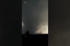
A large wedge tornado develops and tracks over the small town of Cole, Oklahoma on the evening of April 19, 2023. Cole, Oklahoma is located about 10 minutes southeast of Blanchard, Oklahoma, and about a half hour south-southwest of Norman, Oklahoma. The following video is captured from just outside of Washington, Oklahoma of the large tornado, the strong inflow winds picking up dust into the system, and the lightning that was occurring around the storm.
Shot Description
00:00-00:37 Video of the Cole, Oklahoma tornado as it gradually becomes more organized and begins to wedge out as it tracks towards the small town of Cole, Oklahoma.
00:37-01:05 Video of the strong inflow winds picking up dust and dirt and sucking into the strong storm/tornado.
01:05-01:22 Video of the storm/tornado as lighting flashes around it including a cloud-to-ground lightning bolt at the end of the video.
SID: Chris Masters Alexis Nelson
#OKWX #Tornado #cole #oklahoma
To License This Footage For Broadcast, Contact Video @ StormChasingVideo.com
Our Team Merch Store – https://stormchasingvideo.creator-spring.com
Meteorologist and #Stormchaser Simon Brewer and Juston Drake are out in central Oklahoma near the city of Moore and Streaming #Live as the Tornado Watch is in effect, #wedgefest. This powerful #weather system is impacting several states including Oklahoma to the Canadian boarder.
The National Weather Service has issued a #Tornadowatch with storms already showing up on radar. Be prepared and only travel if necessary.
DONT FORGET TO SUBSCRIBE AND LIKE THE VIDEO. MUCH APPRECIATED FROM SCV!!!
To help support our freelancers, https://www.buymeacoffee.com/stormchasing
To License This Footage For Broadcast, Contact Video @ StormChasingVideo.com
SUBSCRIBE – https://www.youtube.com/channel/UCWAN-rRJFLosqgiiIFVpkEQ?sub_confirmation=1
SID: Simon Brewer
To License This Footage For Broadcast, Contact Video @ StormChasingVideo.com
#irl
#okwx wx
#tornado
#Oklahoma
#stormchasing #stormriders
To help support our freelancers, https://www.buymeacoffee.com/stormchasing
To License This Footage For Broadcast, Contact Video @ StormChasingVideo.com
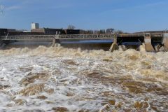
The Mississippi River and it’s tributaries are overfilling their banks and flooding roads, business’s and back yards in Stearns County, Minnesota.
Footage from three different locations, Sartell, MN, Waite Park, MN and Richmond, MN where the Sauk and Watab Rivers feed into the Mississippi River and creating a major flooding event that is all moving down stream in the coming days.
Footage is a mixture of drone and ground clips.
Shot Description
00:00 – Footage of the Mississippi River in Sartell, MN where the Watab River meet down stream of the hydroelectric dam. Great shots of the dam and the high water where all the gates are wide open to let the water pass down stream.
01:31 – Down stream from the damn where the Watab River flows into the Mississippi you can see the high rate of flow and the bridge the goes over the Watab has water already hitting the base of the bridge.
02:05 – Further down stream on the Mississippi River, drone video of the flooding in backyards that are on the river and water is moving closer to the homes and overtaking back yards.
03:24 – Footage from the Chain Of Lakes in Richmond, MN where rising water from the Sauk River has helped the lakes spill over their banks and flood Highway 22. The highway is closed but some motorist decided to ignore the road closed signs and still risk it. This is a mix of drone and ground shot clips.
05:39 – Further down stream on the Sauk River in Waite Park, MN, flooding around a home and local restaurant, “Anton’s” as the Sauk River has spilled over it’s banks and flooded the first floor and the parking lot.
#mississippiriver #flooding #Minnesota #stormchasing
20 Tornadoes In 1 minute.
Extreme Tornadoes from across the United States.
Tornado Compilation Shorts
To help support our freelancers, https://www.buymeacoffee.com/stormchasing
To License This Footage For Broadcast, Contact Video @ StormChasingVideo.com
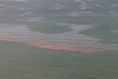
Massive sargassum seaweed bloom reaches the Florida Keys. The 5000 mile wide belt of floating sargassum seaweed in the Atlantic Ocean has drifted ashore in the middle Florida Keys. Video shows seaweed coming ashore and piling up at Cocoplum Beach on Easter Sunday in Marathon Florida. No audio.
Shot Description
1-5) Five varied shots of the massive sargassum seaweed band coming ashore at Cocoplum Beach in Marathon Florida.
6-11) Six varied shots of sargassum seaweed band floating just offshore.
12) Boat with two men boating to edge of seaweed band to observe it.
13-15) Three varied shots of sargassum seaweed condensing near jetty ruins.
16) Wide shot of Cocoplum Beach at Marathon Florida and Atlantic Ocean.
SID: Brian Dombrowski
#Florida #Sargassum #Seaweed #Beaches
To help support our freelancers, buy them coffee. https://www.buymeacoffee.com/stormchasing
To License This Footage For Broadcast, Contact Video @ StormChasingVideo.com
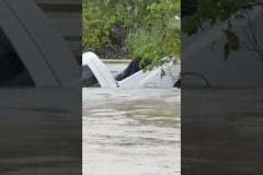
Hero Rescues Drowning Man in Flood when Truck Swept Away – 911 Rescue Mission #shorts
Turn Around, Don’t Drown!
Brandon Sullivan
Columbia, SC
10/04/15
#flood #floodwater #rescue #911 #drowning #truck #southcarolina #storm #hero #heroic
To help support our freelancers, https://www.buymeacoffee.com/stormchasing
To License This Footage For Broadcast, Contact Video @ StormChasingVideo.com