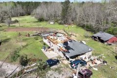
Shot Description
Clips that show intense damage as the Monroe County Tornado tore through Smithville, MS. These scenes will show residential homes destroyed and significant tree damage
00:00 – Destroyed homes and buildings.
00:32 – Fly over of destroyed tree’s that where snapped off from the tornado.
00:45 – Destroyed homes.
01:19 – What was left of a camper or trailer destroyed and sitting in the middle of a field.
01:28 – Damaged building with roof partially intact and more damage scenes.
SID: Michael Gordon
#Tornado #Mississippi #aftermath #drone #dronesurvey #Smithville #monroecounty
To License This Footage For Broadcast, Contact Video @ StormChasingVideo.com
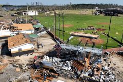
Amory, MS Damaging Tornado Scenes from Drone
Shot Description
00:00 – Highlights of the Significant Tornado Damage across Amory, MS from a drone
01:34 – Tornado Damage to buildings and residential homes
01:49 – Devastating Tornado Damage to the Amory Highschool and Sports Fields
02:51 – Tornado destroys multiple residential structures and commercial buildings and businesses
04:16 – Fly by overview scenes of the damage path through Amory, Mississippi
05:21 – Trees chopped off from Amory tornado
SID: Michael Gordon
#Amory #mississippi #Drone #Tornado #Damage #Aftermath
To License This Footage For Broadcast, Contact Video @ StormChasingVideo.com
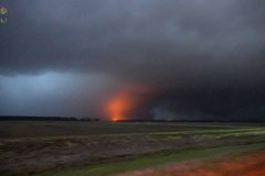
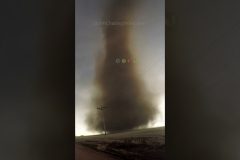
Violent, longtrack, deadly tornado hits Silver City, MS causing significant damage.
All footage shot in/near Silver City, MS during evening darkness on March 24, 2023 by Meteorologists and Storm chasers Juston Drake and Simon Brewer
Shot Description
00:00 massive, violent tornado approaches Silver City, Mississippi
00:27 power flashes as violent tornado enters town
01:41 significant damage in Silver City with emergency response
03:00 close lightning strikes in front of large wall cloud
SID: Simon Brewer Juston Drake
#tornado #mswx #mississippi #Tornadoes #wedgetornado #stormchasing
To License This Footage For Broadcast, Contact Video @ StormChasingVideo.com
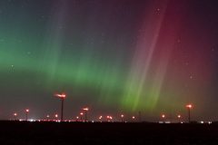
Massive geomagnetic solar storm with an insanely powerful solar wind lights the sky up over a wind farm in central Iowa
As far south as central Iowa, the Aurora Borealis or Northern Lights filled the sky where they normally are barely faint glow on the horizon.
The sky turned various shades of red, green, violet, purple and even a blue hue at times just after sunset as the huge Geo Magnetic Storm slammed into the earth.
Shot Description
Various time lapsed scenes of the Aurora Borealis filling the sky over Central Iowa.
CHAPTERS
—————————————————
0:00 Intro
Music by https://www.epidemicsound.com/release/aurora-borealis/
SID: Doug Kiesling
#auroraboreal #auroraborealis #northernlights #spaceweather #iawx
To License This Footage For Broadcast, Contact Video @ StormChasingVideo.com
Tornado Season 2023 Is Here! – Watch SCV Live Streams on big days #shorts
Tornado Compilation Footage by Simon Brewer and Juston Drake
Locations include: El Reno, Oklahoma, Colorado and Rozel, Kansas
To License This Footage For Broadcast, Contact Video @ StormChasingVideo.com
Dangerous Icy Roads Car Accidents in Winter Blast MN #shorts
Stearns County, MN 3/17/23
Doug Kiesling
To License This Footage For Broadcast, Contact Video @ StormChasingVideo.com
Tornado Warning and Power Flashes threaten Dallas Texas yesterday #shorts
3/16/23 Dallas Fort Worth, Texas
Michael Gordon
To License This Footage For Broadcast, Contact Video @ StormChasingVideo.com
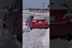
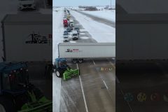
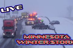
The luck of the Irish was not in the cards for drivers in Minnesota this morning. After the extremely heavy wet snowfall yesterday, the temps dropped from the low 30°F to 4°F overnight causing the wet roads to flash freeze for extremely icy and slippery roads this morning. Add in the winds gusting up over 30 mph with blowing and drifting snow, the roads where a complete mess before noon with dozens of accidents, Jack Knifed Semi Trucks and crash / spin outs into the ditches around the St. Cloud metro area.
Footage shot on the south side of the Saint Cloud metro along Highway 23, Highway 15 and Interstate 94.
Shot Description
00:00 – Crash scene with drone footage and ground footage on Highway 15 south of Saint Cloud, MN.
00:57 – Another crash scene south of the first crash scene on Highway 15. The high winds and blowing and drifting snow made for extremely hazardous driving.
01:29 – Two different vehicles crashed on Highway 15 just south of Interstate 94.
01:51 – Several crash scenes on Highway 23, southwest of Interstate 94. Several vehicles in the ditches.
03:18 – Box Truck off the road in the ditch on Interstate 94
03:49 – POV shots of snow plow on Highway 23.
04:10 – Pickup truck stuck in the center ditch on Highway 23.
04:30 – Semi Truck Jack Knifed and being recovered, POV shot on Highway 23.
05:15 – Blowing and drifting snow over Highway 15 and Interstate 94.
05:35 – Car stuck in the middle of Highway 23 just south of Interstate 94.
SID: Doug Kiesling
#MNWX #BlowingSnow #Accidents #Crash #jackknife #Drone #icyroads #winter
To License This Footage For Broadcast, Contact Video @ StormChasingVideo.com
Rescuing Jackknife Semi Blocking Interstate in Winter Storm #shorts
3/16/23 Fargo, ND
Jason Bednar
To License This Footage For Broadcast, Contact Video @ StormChasingVideo.com
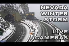
Traffic camera scan around Lake Tahoe Nevada and other areas affected by the Winter storm on March 5 2023. Major winter storm with heavy snow and high winds expected through Monday morning. Audio is area NOAA weather and/or public safety radio. Not a source of official traffics information. Source NV DOT.
#nvwx
#traffic
#winter
#snow
Tanker truck crash on US 15 in Frederick. Tanker caught fire and exploded multiple times. Fire spread to nearby house and car. Combustant leaked into storm drain system and started fires in nearby park.
Shot Description
TC in Description
00:00 – First hoses on burned tanker
00:09 – Fireman hosing tanker
00:17 – wide sot – stopped traffic, billowing smoke
00:27 – medium shot – water hitting tanker
00:35 – medium shot – tanker and burned out truck cab
00:41 – medium shot – burned out car
00:49 – firemen on roof of burned house
01:00 – fire truck and tanker
01:08 – wide shot – EMTs
01:17 – medium shot – EMTs
01:21 – wide – smoke billowing from storm sewer grate
01:27 – pan from tanker to stopped traffic
01:40 – wide – water spraying on tanker, fire vehicle foreground
01:53 – wide – burned house
02:02 – wide – highway, road signs, fire truck, tanker and foam in background
02:11 – firemen walking away from burned car
SID: Warren Morningstar
#MDWX #Explosion #FuelSpill #FuelTanker #Accident #pollution
To License This Footage For Broadcast, Contact Video @ StormChasingVideo.com

Semi Truck Fuel tanker crash with explosion along US15 in Frederick, Maryland. Apparently from initial reports this is a vehicle vs fuel truck that has exploded and is creating an environmental hazardous situation at the scene with the spilled fuel and the risk of exploding and damaging the surrounding neighborhood.
Shot Description
0-36 big flame firetruck drives by w/ siren
37-49 big flames medium shot
50-1:15 fire scene dynamic
1:15-1:20 fire vehicle drives by smoke out of manhole
1:30-1:30 fire scene
1:30-2:21 firefighters battle flames
2:22-2:26 fire trucks arriving
2:27-2:36 scene setter
2:37-2:44 big flame firetruck arriving
2:45-3:01 smoke out of manholes
3:01-3:21 medium shot of scene
3:22-3:32 freeway scene smoke out of sewer
3:34-3:48 fire trucks arriving
3:49-4:06 tight shot smoke out of manhole
4:07-4:12 ladder truck arrives
4:13-4:25 scene setter
4:26-4:37 wide shot of people looking on
4:37-4:53 ultra wide of scene
4:54-4:58 tight shot fire fighters
4:59-5:45 fire fighters battle flames
5:46-5:51 wide shot of area
SID: Sierra Harrop
#MDWX #Explosion #FuelSpill #FuelTanker #Accident #pollution
To License This Footage For Broadcast, Contact Video @ StormChasingVideo.com
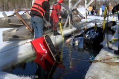
Earlier in February a truck went through Pickerel Lake in Bayfield in northern Wisconsin. Due do ice and weather conditions the recovery had to wait until today. The truck ended up in about 40 feet of water on it’s side. The crews had to use airbags to aid in the recovery efforts, as the truck also sunk halfway in the muddy button. Luckily the driver was able to escape without injuries. The recovery team, along with the diving team had their work cutout for them. It was a long hard recovery for both of the teams. At the end of the day, the recovery was successful.
Shot Description
Clip 1. Shows the recovery equipment ready to do it’s job.
Clips 2-4. The crew cutting the ice.
Clip 5. A diver getting ready to head into the water.
Clip 6. The diver heading into the water to hook straps to the truck.
Clip 7. The crew helping to guild the airbags into the water for the diver to pull down to hook up to the truck.
Clip 8. A different diver heading into the water.
Clip 9. The crew starting to pull the airbags and truck up.
Clip 10. The airbags breaking the surface of the water.
Clips 11-12. The crew pulling the recovery equipment, with the airbags and truck to better ice.
Clip 13. Shows part of the truck near the bottom of the ice.
Clip 14. Shows the crew has got two tires out of the water.
Clips 15-17. The crew is pulling the truck up out of the water.
Clips 18- 20. The crew pulling the recovery equipment and truck to better ice.
Clip 21. Shows the truck out of the water.
Clip 22. The crew flipping the truck back on it’s four tires.
Clip 23. The truck being pulled towards the shoreline.
SID: Dirk Miller
#WIWX #thinice #Iceroad #Icerecovery
To License This Footage For Broadcast, Contact Video @ StormChasingVideo.com
Tornado Warned Supercell in Ohio! Crazy February Weather #shorts
2/27/23 Columbus, OH
Simon Brewer
To License This Footage For Broadcast, Contact Video @ StormChasingVideo.com
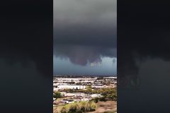
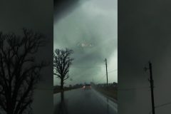
Multiple tornado-warned supercell thunderstorms pass over Columbus, OH causing dangerous conditions, including accidents.
All footage shot in/near Columbus, OH during evening daylight on February 27, 2023 by Meteorologist Simon Brewer
Shot Description
00:00 Tornado Sirens blare with tornado warned storm
00:11 large rotating wall cloud over Columbus, OH
00:52 large rotating wall cloud behind farm
01:13 large rotating wall cloud crosses road
01:30 tornado warned storm crosses road
01:58 rotating wall cloud crosses I-70
02:07 truck crashed into wall from supercells crossing highway
02:13 multi vehicle accident during tornado-warned storm
02:24 heavy traffic in Columbus from tornado-warned storms
SID: Simon Brewer
#OHWX #Tornado #stormchasing
To License This Footage7 For Broadcast, Contact Video @ StormChasingVideo.com
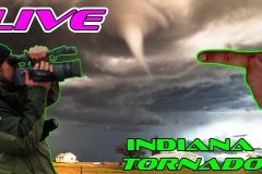
Meteorologist and #Stormchaser Simon Brewer is out Streaming #Live in Ohio as a significant #Tornado Threat Enhances. The National Weather Service has now issued an enhanced area for extremely dangerous winds and very fast moving #tornadoes. This #coldcore tornado setup will affect all areas in #Ohio including #Dayton, #Cincinnatti , and #Columbus. Tornado Watch for Ohio.
DONT FORGET TO SUBSCRIBE AND LIKE THE VIDEO. MUCH APPRECIATED FROM SCV!!!
SUBSCRIBE – https://www.youtube.com/channel/UCWAN-rRJFLosqgiiIFVpkEQ?sub_confirmation=1
SID: Simon Brewer
To License This Footage For Broadcast, Contact Video @ StormChasingVideo.com
#irl
#ohwx
#tornadowatch
#ohiotornadoes
#ohiotornado
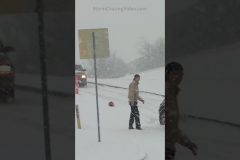
Blizzard travel hazard in Minnesota this week #shorts
Renville County, MN 2/15/23
Doug Kiesling
To License This Footage For Broadcast, Contact Video @ StormChasingVideo.com
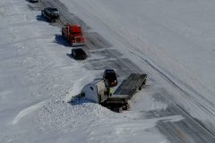
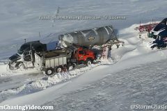
North Dakota Department of Transportation plows rescuing stranded vehicles on Interstate 29, one mile north of Argusville, North Dakota. Last night brutal blizzard conditions in Cass County along both Interstate 29 and Interstate 94 set in around 7:00 PM, multiple vehicles became stranded and motorists were forced to spend the night in their vehicles surrounded by raging winds and blinding snow.
Shot Description
Drone video of plows clearing snow and slowly freeing semis to reopen southbound Interstate 29 at Argusville, North Dakota.
#NDWX #Stranded #blizzard #winterstorm
To License This Footage For Broadcast, Contact Video @ StormChasingVideo.com
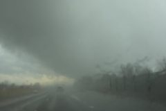
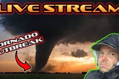
#StormChaser Michael Gordon is Streaming #Live in Mississippi as the the #SevereWeather #Tornado Threat has increased happening Mississippi this evening and on into the overnight hours. Models show EF2 plus #tornadoes. The storm is set to bring severe winds and deadly tornadoes. I will be streaming from across #Mississippi.
SID: Michael Gordon
To License This Footage For Broadcast, Contact Video @ StormChasingVideo.com
PayPal – https://paypal.me/ParamountWeather?country.x=US&locale.x=en_US
Venmo – https://www.venmo.com/u/ParamountWeather
#stormchasing
#irl
#StormChasing
#mswx
#supercell
Running from the Largest Tornado on Record #shorts
El Reno, OK 5/31/13
Chris Collura
To License This Footage For Broadcast, Contact Video @ StormChasingVideo.com
Winter weather causes hazardous driving conditions #Shorts
To License This Footage For Broadcast, Contact Video @ StormChasingVideo.com
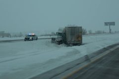
Ice covered I-29 caused multiple vehicles to lose control this morning and end up in the median or ditch, plows were out scraping and sanding. All shots were along I-29 from the ND/SD border tp Brookings, South Dakota, except for the final clip of the jack-knifed semi, which was one mile north of the border in North Dakota. The area is just north of the impending winter storm starting later today.
Shot Description
1) DOT sign to slow down due to icy roads and high winds
2) Sherriff on scene of spin out
3) Plow blasting ice and snow off I-29 northbound
4) Semi being towed out of median
5) Semi in ditch with Highway patrol on scene
6,7) Plow removing snow
8) Closeup of icy road with semi slowly driving
9) Multiple vehicles in median
10) Ice gradient shown on surface
11) Jack-knifed semi one mile north of SD/ND border
#icestorm #freezingrain #slickroads #icyroads #SDWX
To License This Footage For Broadcast, Contact Video @ StormChasingVideo.com
Aftermath of Griffin Georgia Tornado – Drone
Shot Description
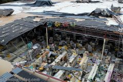
00:00 (5 Clips) Hobby Lobby Roof destroyed by Tornado that ripped through Griffin, Georgia
00:46 Roofing and Debris hanging from powerlines in the central part of Griffin, GA
00:53 (9 Clips) Trees completely crushed homes from the tornado.
02:01 Trees leveled from the dangerous tornado
02:09 (10 Clips) Extreme Extensive damage to homes as trees uprooted and fell through roofs and buildings with ongoing search and rescue.
03:25 (3 Clips) Ground Footage of damage caused by the tornado in Spalding County, Georgia.
SID: Michael Gordon
#GAWX #Tornado #StormDamage #Aftermath
To License This Footage For Broadcast, Contact Video @ StormChasingVideo.com
Track live on GPS: https://glympse.com/BWnB-Ypzg
New live stream of for the Winter Storm and Ice Storm Warning hitting the the Central and Southern parts of Minnesota today, 1/3/2023
We will be live covering this event from around the Saint Cloud, MN area to the Twin Cities Metro area looking for various scenes of heavy snow, freezing rain, and traffic issues.
To License This Footage For Broadcast, Contact Video @ StormChasingVideo.com
#MNWX
#winterstorm
#icestorm
#IRL
#StormChasing