Fort Myers Beach Search and Rescue Operations in Total Destruction from Hurricane Ian
Shot Description
Clip 1. Search and Rescue Teams digging through home on top of piles of debris
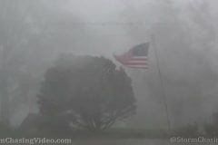
Clip 2. American Flag waving in the wind where a home is completely gone with the ocean and sunset in the background
Clip 3. Search and Rescue Teams on top of a pile of debris from homes searching for survivors
Clip 4. Piles of debris in heaves near roadway
Clip 5-10. Businesses and homes obliterated from the storm surge from Hurricane Ian
Clip 11. Looking out towards the beach with standing pillars and the sunset in the background
Clip 12-16. Mass Destruction of all buildings and homes across the island of Fort Myers Beach
Clip 17. American Flag waving in the wind strapped to the post where a home used to be with sunset
Clip 18-20. Nothing left standing just the stilts that homes used to once sit on
Clip 21. Residents packing things up and riding there bikes down the roadway
Clip 22-25. Homes scattered into piles of debris from storm surge
Clip 26-28. Search and Rescue team along with Army National Guard searching for survivors and the deceased
SID: Michael Gordon
To License This Footage For Broadcast, Contact Video @ StormChasingVideo.com
Our Team Merch Store – https://stormchasingvideo.creator-spring.com
#FLWX
#Ian
#StormSurge
#hurricaneIan
#Weather
Storm surge inundates Myrtle Beach, SC as Hurricane Ian makes his second land fall within 48 hours. Package also contains footage of the aftermath, damage and clean up.
Shot Description
0:00- Traffic lights swaying wildly in the wind as Ian makes second lanfall near Myrtle Beach, SC.
0:13- Storm surge inundating Ocean Boulevard in Myrtle Beach, SC.
0:29- A motorist attempts to drive through deep flood waters, but thinks better of it and turns around.
0:46- A man walks through knee deep storm surge on Ocean Boulevard in Myrtle Beach, SC.
1:03- Motorists drive through deep storm surge in Myrtle Beach, SC.
1:36- Drive by POV shot of a motorist stuck in a ditch on I-95 near Myrtle Beach, SC.
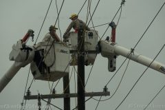
1:49- Power crews tend to downed lines and trees in Myrtle Beach, SC.
2:04- Various shots of storm surge and motorists stranded in deep flood waters in Myrtle Beach, SC.
2:29- A large tree falls on power lines in Myrtle Beach, SC.
2:44- Power crews work high above the ground in cherry pickers to restore power to Myrtle Beach, SC.
3:03- Various shots of storm surge and high waves in Myrtle Beach, SC.
3:25- Part of a dock washes onto the beach and rests next to a hotel pool in Myrtle Beach, SC.
3:41- Various shots of sea foam coating businesses along Ocean Boulevard in Myrtle Beach, SC. Various damage shots on Ocean Boulevard.
SID: Scott McPartland
To License This Footage For Broadcast, Contact Video @ StormChasingVideo.com
Our Team Merch Store – https://stormchasingvideo.creator-spring.com
#SCWX
#Ian
#StormSurge
#hurricaneIan
#Weather
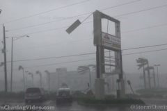
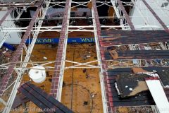
Hurricane Ian aftermath scenes from Osprey FL showing a huge earth anchored Walmart sign flipped upside down, roof ripped off, massive tree blocking road, compare contrast of modern roof performance to native Indian chickee hut roof, damage at Casey Key’s Blackburn Point Bridge.
Shot Description
1) Stop sign scoured at Wharf Rd and US-41 near Sarasota Co fire dept.
2-6) Five shots of Osprey Walmart’s massive sign hanging upside down ripped off foundation.
7,8) Billboard sign damage.
9-11) More sign damage.
12-15) Four shots of roof damage, with roof peeled off house. Conventional construction.
16) Native Indian chickee hut roof intact on Little Sarasota Bay.
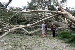
17-19) Massive tree with power pole blocking Vamo Dr.
20) Palm tree down and fir tree stripped of branches.
21-22) Utility pole severed.
23) Power lines dangling over road with guy riding bike under and car pulling away.
24-34) Eleven scenes of damage at Casey Key Blackburn point bridge. Signal damage.
35,36) Two shots of bent flag pole and tattered US flag at Casey Key Blackburn point bridge.
SID: Brian Dombrowski
To License This Footage For Broadcast, Contact Video @ StormChasingVideo.com
Our Team Merch Store – https://stormchasingvideo.creator-spring.com
#FLWX
#Ian
#hurricaneIan
#Weather
Hurricane Ian left a trail of damaged & flooded buildings and destroyed boats along the west coast of Florida.
Shot Description
SHOT 1: A mobile home completely destroyed by Ian’s fierce winds near Ft Myers FL.
SHOT 2: Aerial view, shot in the morning, of a hotel with damaged roof on Charlotte Harbor from upper floors looking down.
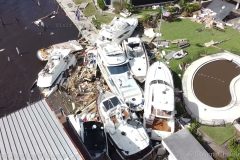
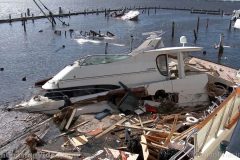
SHOT 3: Aerial view, shot in the morning, of wrecked yachts piled up in a marina along the Caloosahatchee River in Cape Coral FL.
SHOT 4: Shot of damaged boats in a marina along the Caloosahatchee River in Cape Coral FL.
SHOT 5: One of many damaged marinas along the Caloosahatchee River in Cape Coral FL.
SHOT 6: Cars stuck in flooding roads near Port Charlotte FL.
SHOT 7: Rolling shot of destroyed walls and homes near Port Charlotte FL.
SHOT 8: Debris in a fence marks the storm surge high water line in Cape Coral FL.
SHOT 9: A destroyed gas station awning in Port Charlotte FL.
SHOT 10: Search and rescue teams heading down I-75 to help those in need in southwest FL.
SHOT 11: Rolling shot of a large tree being removed from a house in Cape Coral FL.
SID: StormChaingVideo
To License This Footage For Broadcast, Contact Video @ StormChasingVideo.com
Our Team Merch Store – https://stormchasingvideo.creator-spring.com
#FLWX
#Ian
#hurricaneIan
#Weather
Million dollar yachts washed ashore by storm surge are piled up behind the Pinchers Yacht Club in Fort Myers in the aftermath of Hurricane Ian. Various other shots of boats washed ashore, hotels gutted, and drivers navigating flooded streets in Fort Myers, FL.
Shot Description
0:00- Various shots of yachts sunken or destroyed by storm surge at the Pinchers Yacht Club in Fort Myers, FL.
1:27- A hotel lobby is gutted by wind and storm surge near Fort Myers, FL
1:38- A boat lies on Rt 41 in Fort Myers, FL
1:52- Panning shot of a hotel damaged by wind and storm surge near Fort Myers, FL
2:07- A Speedway gas station overhang is destroyed by wind near Fort Myers, FL.
2:33- Cars drive through deep flood waters in the aftermath of Hurricane Ian in Fort Myers, FL.
2:48- A boat washed ashore lies on Rt 41 as a Fort Myers fire truck drives by, Fort Myers, FL.
3:03- Shot of a sunken boat behind the Pinchers Yacht Club in Fort Myers, FL.
SID: Scott McPartland
To help support our freelancers, buy them coffee. https://www.buymeacoffee.com/stormchasing/
To License This Footage For Broadcast, Contact Video @ StormChasingVideo.com
Our Team Merch Store – https://stormchasingvideo.creator-spring.com
#FLWX
#Ian
#hurricaneIan
#Weather
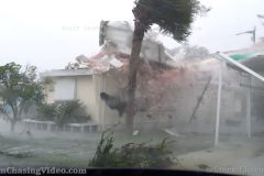
Neighborhood destroyed by violent hurricane winds from Category 4 Ian in the community of Placida, Florida. Roofs, trees, houses and debris flying through air.
All footage shot in Placida, FL during afternoon daylight on September 28, 2022 by Meteorologists Juston Drake and Simon Brewer
Shot Description
1. roof ripped off home, then a roof from another home hits house
2. debris flying through neighborhood
3 & 4. homes damaged by violent winds
5. palm tree falls down from strong winds
6. roof flies through air
7. palm tree falls down in high winds
8-21. various shots of buildings and neighborhood destroyed by violent winds
22. Meteorologist Juston Drake stands in high winds
SID: Simon Brewer Juston Drake
To License This Footage For Broadcast, Contact Video @ StormChasingVideo.com
Our Team Merch Store – https://stormchasingvideo.creator-spring.com
#FLWX
#Ian
#hurricaneIan
#Weather
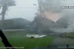
Damage after NE eyewall passage shot while in the eye of Ian. Crane Collapse, Building Damage.
Also shot conditions of Ian with 120+ mph winds
Shot Description
00:00 – 00:37 – Crane Collapse
00:37 – 00:48 – Crane #2 Collage
00:48 – 1:33 – Building Structure Collapse
1:33 – 2:14 – Sign getting ripped apart in 120+mph winds
2:14- 2:39 – Howling winds and debris
3:39 – END – Vertical shot (unexpected while doing other work) Roof ripped off house
SID: David Baxter
To License This Footage For Broadcast, Contact Video @ StormChasingVideo.com
Our Team Merch Store – https://stormchasingvideo.creator-spring.com
#FLWX
#Ian
#hurricaneIan
#Weather
Fast edit from our live stream with Simon Brewer. Bugs burned into the screen from our live streaming computer system. Footage of trees falling in front of the camera, home being torn apart highlights from the live stream in the worst of the eye wall as it hit Placida, FL. This is from our live system so it is a lower resolution bitrate.
Shot Description
Various clips of eye wall from Hurricane Ian hitting Placida, FL where it downed trees with flooding, flying debris and structures being torn apart.
SID: Simon Brewer
To License This Footage For Broadcast, Contact Video @ StormChasingVideo.com
Our Team Merch Store – https://stormchasingvideo.creator-spring.com
#FLWX
#Ian
#hurricaneIan
#Weather
Aerial and ground video showing the vulnerable coastal areas of Siesta Key Florida in Sarasota County Florida as Hurricane Ian targets the Suncoast of Florida. Turtle beach, Midnight pass, Crescent beach, Siesta Key Marina, Stickney Point bridge areas of Siesta Key. Aerial shots have no audio.
Shot Description
1,2) Two aerial shots of condos just south of Turtle beach on Siesta Key on the Gulf of Mexico. This area is slated for FEMA beach restoration in late 2023. Seems like that may be too late.
3,4) Two aerial shots of a beach front home near Midnight Pass south of Turtle Beach that has it’s pool deck at the water line already from erosion the last decade.
5) Long traveling aerial shot from south to north of Midnight pass area and vulnerable waterfront homes and condos just north of it.
6,7) Aerial shots of in-and-out boat storage at Siesta Key Marina near Crescent beach and Stickney point bridge.
8) Stickney point bridge over intracoastal waterway between mainland Sarasota and south end of Siesta Key.
9) Another aerial of Siesta Key Marina.
10-17) Seven shots of shuttering at Crescent beach market plaza.
SID: Brian Dombrowski
To License This Footage For Broadcast, Contact Video @ StormChasingVideo.com
Our Team Merch Store – https://stormchasingvideo.creator-spring.com
#FLWX
#Ian
#hurricaneIan
#Weather
Stunning Tornado Rope Out Phase! #shorts
Ashby, MN
7/8/20
Melanie Metz
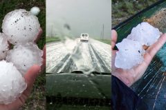
The most epic, biggest hail storms to hit the USA ever caught on film. A compilation of raw, up close footage captured by various videographers from the Storm Chasing Video team.
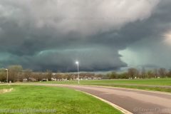
Large storms formed in a front range Flood Watch prompting Flash Flood warnings in and around Castle Rock, CO.
Shot Description
1. Meadows Pkwy in Castle Rock with mudslide and debris flow being removed by workers via shovel and bulldozer
2. Workers shovel mud into bulldozer
3. Traffic is rerouted for mudslide
4. Convection over Castle Rock area buttes
5. Flowers in front of storm
6. Storm seen from I-25 North bound
7. Updraft with brief rotation
8. Timelapse of storm base and scud
9. Fog in valley timelapse
10. Fog over Ranch
11. Storm Base in distance
12. Pan across dramatic storm base
SID: Terrence Cook
To License This Footage For Broadcast, Contact Video @ StormChasingVideo.com
Our Team Merch Store – https://stormchasingvideo.creator-spring.com
#COWX
#flashflooding
#weather
#mudslide
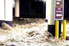
Epic flooding hits the strip and floods the garage of the Linq Hotel.
Footage of the thunderstorm and lightning over the Las Vegas Strip and then lots of heavy flash flooding flowing through the Linq Hotel parking lot.
Shot Description
B-roll footage of the flash flooding and lightning on the Las Vegas strip in world famous Las Vegas, NV
SID: Jason Caster
To License This Footage For Broadcast, Contact Video @ StormChasingVideo.com
Our Team Merch Store – https://stormchasingvideo.creator-spring.com
#NVWX
#lightning
#flashflooding
#weather

Flash flooding from thunderstorms overwhelm drainage systems, causing numerous drivers to stall their vehicles on July 26, 2022 in Colorado Springs, Colo.
Shot Description
00:00 – Expensive car drives through a flooded street and stalls.
00:13 – A Subaru drives through flooded street and stalls, smokes.
00:40 – A red SUV drives through flooded street, off camera stalls with loud engine noise.
01:00 – Vehicle drives through flooded intersection at high speed.
01:10 – Wide shot of flooded intersection.
01:18 – Tight shot of heavy traffic and flooded intersection.
01:32 – Drivers at intersection unsure about entering flooded street and get honked at.
01:48 – Shenanigans at flooded street as drivers indecisive about entering flooded street, causing gridlock. Proceeds after a few honks.
02:13 – People push stalled vehicle away from flooded street.
02:31 – Jeep drives through flooded street, nearly hitting stalled vehicle.
02:47 – Wide shot of deep water over street.
02:57 – SUV drives through deep floodwater.
03:09 – Truck towing a trailer proceeds through deep water on street with passenger keeping an eye on water depth. Another Vehicle proceeds shortly after, with water over hood.
03:35 – Vehicle briefly stalls in deep water over hood.
SID: Trevor Cokley
To License This Footage For Broadcast, Contact Video @ StormChasingVideo.com
Our Team Merch Store – https://stormchasingvideo.creator-spring.com
#COWX
#FlashFlooding
#Weather
#FlashFlood
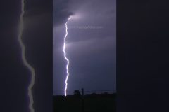
WILD LIGHTNING STRIKES! Oklahoma Style #shorts
Tornado Overhead!! Close Encounters with Wild Weather #shorts
Simon Brewer & Juston Drake
Colorado June 19th, 2018

Wild Ride inside a Hurricane with Storm Riders, Simon Brewer and Juston Drake. They risk their lives to document the storm and gather data from start to finish. In this documentary, they reveal many tips and tricks on how they chase hurricanes, from equipment they use to food and supplies. This hurricane created a massive storm surge and serious damage to the Grand Isle, LA area.
NEW, never released and un-censored raw footage. We are finally releasing this self-made documentary for the start of Hurricane Season 2022. In 2012, Simon and Juston were the only chasers to stay on the island and go into the storm, Hurricane Issac. This hurricane impacted the same locations that were devastated by Hurricane Ida in 2021.
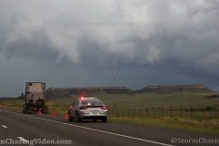
Live storm chasing footage from the field in central Minnesota where the Storm Prediction Center has issued Particularly Dangerous Situation (PDS) Tornado Watch #293.
Live feed will be up through the evening.
SID: Doug Kiesling
To License This Footage For Broadcast, Contact Video @ StormChasingVideo.com
#MNWX
#Tornado
#StormChasing
Tornado five miles south of Artichoke near Hwy 12 on 600th Ave.
Shot Description
1) Approaching right edge of tornado
2) Full shot of tornado
3) Rear inflow winds
SID: Jason Bednar
To License This Footage For Broadcast, Contact Video @ StormChasingVideo.com
#MNWX
#Tornado
Twin Tornadoes! Today is Benkelman NE Tornado 1 Year Anniversary. Filmed on 5/26/21. Tim Baker. #shorts
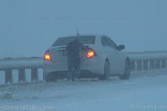
A major late season winter storm dumps heavy wet snow across the Front Range on May 20, 2022 near Colorado Springs and Monument, Colo.
Shot Description
00:00 – Vehicle struggling up Monument Hill on I-25 near Monument, Colo.
00:23 – Vehicle in Monument, Colo. spinning tires while heavy snow blows by.
00:37 – Person pushing stuck vehicle through snow.
00:48 – Close shot of Two people pushing stuck vehicle through snow.
00:55 – Wide shot of people pushing stuck vehicle with other vehicles nearby with hazard lights on.
01:00 – Mid shot of people clearing snow from van.
01:14 – Close shot of people clearing snow from van.
01:28 – Truck carrying trailer fishtails in heavy snow.
01:42 – Truck with trailer spinning tires in heavy snow.
01:54 – Plows passing by on I-25 in Monument, Colo.
02:10 – Wide of snow covered tree with large branch broken off.
02:16 – Close of snow covered tree with broken branch.
02:26 – Mid of snow plastered fence with tree branches draping top.
02:35 – Close of snow covered fence with tree branches draping top.
02:42 – Wide of small trees weighed down by snow.
02:48 – Close of small trees weighed down by snow.
02:54 – Car completely covered in snow.
03:00 – Wide of car completely covered in snow.
03:04 – Broken tree branches littering ground under tree.
03:10 – Closer shot of broken tree branches littering ground.
03:16 – Snow plastered stop sign.
03:24 – Snow covered trees.
03:27 – Snow plastered sign.
03:35 – Street light with heavy snow blowing by.
SID: Trevor Cokley
To License This Footage For Broadcast, Contact Video @ StormChasingVideo.com
#COWX
#Winter
#Accidents
#Spinouts
A tornado that touched down around 5:50 PM on May 12th, 2022, caused extensive damage to several properties in Castlewood, SD. The school lost its roof over the gymnasium and its exterior block walls collapsed inward onto the floor. Video includes a drone view of the main path of the tornado over several damaged homes along with ground views of the homes and uprooted trees. Two semi trucks tipped over on I-29 two miles south of Watertown, SD.
Shot Description
0:00-1:29 Drone flyover of the damage path
1:30-1:58 Ground views in Castlewood of damaged homes and uprooted trees
1:59-2:21 Semi trucks on their side on Interstate 29
SID: Jason Bednar
To License This Footage For Broadcast, Contact Video @ StormChasingVideo.com
#SDWX
#tornadodamage
#StormDamage
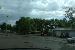
Raw footage from the midday storm that hit Saint Cloud, MN
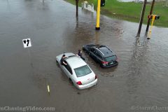
A swath of thunderstorms dropped heavy rainfall amounts very quickly this morning to already saturated Fargo, ND. Flash flooding turned one intersection into a lake and rushed morning commuters attempted to drive through it, many were unsuccessful, and forced to push their vehicles out of the high water.
Intersection of 15th Street and 32nd Ave South in Fargo.
Shot Description
1) A sedan driving through very high water in flooded intersection
2) Another sedan stalled with wake from other vehicles crashing into it
3) A city worker checking on a motorist in high water
4) Vehicles driving in high water
5) Aerial view of passengers exiting their vehicle through windows and pushing
6) A woman pushing her car out of the water
7) A good Samaritan voluntarily entered the high water to push out a strangers car soaking their clothes and shoes
8) A motorist pop his hood without shoes on to check things out after stalling
9) Drone aerials of cars driving in high water creating wakes.
SID: Jason Bednar
To License This Footage For Broadcast, Contact Video @ StormChasingVideo.com
#NDWX
#Fargo
#flooding
#FlashFlooding