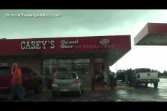
This is the start of our new series for you, our viewers of all of our news video’s that right now were calling “Behind The Chase”. We are not going into forecasting or why the storm did what it did. We are going to focus on what we did as chasers and what was happening behind he camera.
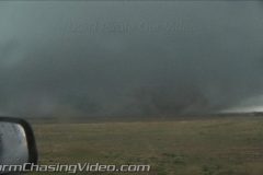
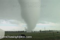
In this video blog of Behind The Chase, we look at the famous Quinter Kansas Wedge Tornado. The tornado was a close call for several chasers.
If you have questions about StormChasingVideo.com or have an idea about another video you want us to review in a future blog, or even questions about another video, this is the best way to reach us each week as we will be actively reviewing the comments for this video.
Oh and where to get the shirts, http://www.ChasersEdge.com is where I buy the shirts.
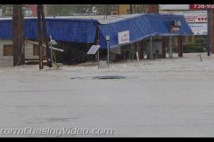
Deadly flooding continues near Columbia, SC as rainfall has led to numerous damn breaks, and flash flooding. Many cars are underwater with homes being flooded and water rescues underway.
Shot 1 shows a building nearing collapse with water running over the roof of a car
Shot 2 shows a flooded road with rapidly moving water over a car.
Shot 3 shows multiple cars underwater.
Shot 4 shows another set of cars underwater.
Shot 5 shows cars and homes being flooded
Shot 6 shows a wider shot of a car stranded with completely covered roads
New amazing, yet terrifying night vision security cam footage of Friday mornings F2 Tornado hitting a home on Saint Johns Island, SC. Footage shows debris flying around the security camera’s and also includes still images of the damage after the tornado hit.
Heavy wind driven tropical rain resembled tropical storm conditions as a squall moved through Anna Maria Island this afternoon. Areal flood advisories are in effect. Wind driven tropical rains, great shots of Florida people dealing with the rain, traffic in road flooding.
Shot List
1) Girls in bikinis walk the Anna Maria City pier in rain.
2) Vertical banner bending hard in wind driven rain.
3) Flag and palm tops obscured in heavy wind driven rain.
4) Palm tree tops in heavy wind driven rain (tight)
5) Tigher shot of banner in wind/rain.
6,7,8) Three more shots of palms and structures in heavy wind/rain.
9) Wide shot of Anna Maria city pier.
10,11) Two shots of guy in “Rays” shirt with black umbrella walking pier in wind/rain.
12) Girls in binikis walking off pier in rain.
13) People with umbrellas on pier in wind/rain.
14) Tight shot of guy in green rain coat in rain walking pier.
15) Tight shot of guy in blue rain coat in rain walking pier.
16) Pier pilings with rain falling on bay waters.
17) Woman sitting on beach in rain with rain umbrella.
18) People on sidewalk walk thru frame with clear rain covers on.
19,20,21) Three shots of traffic splashing in road flooding on Gulf drive on Anna Maria Island.
22) Tire of parked truck in flooded road showing 8″ of water.
23) Flooded yard on Anna Maria Island.
Footage of powerflashes from tornadoes, close dramatic lightning flash, truck in ditch from tornado, dramatic time lapse of tornadic supercell with rotating wall cloud, shots of St. Louis metro City street flash flooding and tornadic storm slamming city.
All footage shot in evening daylight & darkness on June 28, 2015 in/near St. Peters, Eolia, and Brentwood in St. Louis Metro Area.
Shot List:
1.. POV driving shot of police vehicle passing en route to tornado with severe high winds blowing heavy rain & hail over roadway with tornadic supercell thunderstorm in Eolia, MO
2. POV driving shot of semi truck in ditch/median from tornado with emergency vehicles arriving on scene in Eolia, MO
3-5. various shots of tornado-warned supercell on Missouri-Illinois Border
6-8. various shots of rotating wall cloud with tail cloud and setting sun with tornadic supercell thunderstorm in St. Peters, MO (St. Louis Metro)
9. POV driving shot of high winds blowing heavy rain & hail in St. Peters, MO
10 & 11. POV shots of close dramatic lightning strike with tornadic supercell in St. Peters MO
12 & 13. POV driving shots of powerflash from possible tornado in Brentwood (St. Louis Metro)
14-16. POV driving shots of wall cloud and high winds blowing heavy rain/hail in Brentwood (St. Louis Metro) with traffic
17. Pushed-in shot of car turning around on flooded road from flash flood in Brentwood (St. Louis Metro)
18. POV driving shot of traffic driving through flooded road in Brentwood (St. Louis Metro)
19. Dramatic time lapse shots of powerful tornado-warned supercell thunderstorm over on Missouri-Illinois Border
20-25. various shots of rotating wall clouds on Tornado-warned supercell thunderstorm near Missouri-Illinois Border
26 & 27. shots of powerflash from tornado in Eolia, MO
Live GPS tracking link: http://goo.gl/H9SmR7
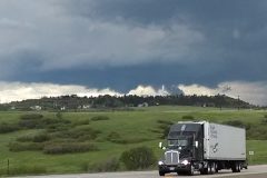
Another day of severe storms in the high plains along the Palmer Divide in Colorado to the east and southeast of Denver. Justin King is out chasing and live streaming.
Copyright 2015 StormChasingVideo.com & LiveNewsVideoNetwork.com
*** NO THIRD PARTY USE W/O LICENSE ***
*** Contact StormChasingVideo.com for Licensing ***
SID=JustinK
TVID=
Storm Chaser Verne Carlson was chasing the Tornado near Simla, CO when he followed what he thought was a country Dirt Road to get out of the path of the storm.
The dirt road ended up becoming a dead end road that was basically a several mile long driveway to someones house and it did not continue as the map suggested.
Clip 1 Large Violent tornado over an open field.
Clip 2 Large Violent tornado with huge hail falling and splashing into a pond.
Clip 3 Dash camera footage of the tornado moving towards the pickup truck.
At time code 2:11 the tornado forms right behind the house. The winds are blowing from left to right in the video.
At time code 3:20 the tornado hits Verne’s truck and spins 90 degrees to the left.
At this point the winds shift from Left to Right and become more head on with large debris flying towards the camera.
At time code 3:30 the winds and debris are now flying and blowing from Right to Left. A 180 degree shift in the winds as the tornado hits the vehicle.
The truck sustained serious damage. The topper on the truck bed was ripped off and the frame appears slightly twisted now.
Dash Camera footage ends at Time Code 3:41
Clip 4 Hand held camera of the same content form when the tornado hit the truck but is extended footage that shows a lot of debris hitting the truck and then the tornado moving off after it hit the farm and the chasers. This clip ends at 9:58
Clip 5 Aftermath walk around of the Ford Ranger of what was left of the truck. The topper was ripped from the truck bed, the contents in the truck bed that were not bolted down were sucked out of the truck bed.
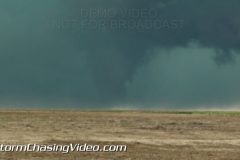
A massive supercell developed southwest of Lamar, Colorado and intensified bringing hail up to baseball size, several funnels, and a large tornado that appeared long enough to get a view before the rain and hail wrapped it up. The tornado that touched down lifted before it reached US-287 south of Lamar and didn’t do any reported damage. The hail grew to baseball size and damaged car windshields as that core did make it across US-287.
Scene 1: Shot of large tornado southwest of Lamar in Prowers County, Colorado.
Scene 2-4: Shots of funnel clouds from the storm prior to the tornado, two confirmed before the tornado formed.
Scene 5: Structure shot of storm as it approached US-287 south of Lamar.
Scene 6-10: Various shots of large hail, up to baseball size, falling during the storm.
Scene 11: Shot of cracked windshield during hailstorm.
Scene 12: High winds in the trees as the storm rages on.
Scene 13: Shot of five large stones collected after the storm, one measuring 2.5″
Scene 14: Shot of two stones compared to a blue golfball and a lime.
Scene 15: Narration with radar behind hail in hand.
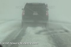
A supercell with massive hail unloads on the town of Pecos and surrounding areas dumping 2-inch plus hail accumulating a foot deep. US-285 was brought to a crawl due to accumulating hail with several vehicles stuck on the side of the road. Motorists in navigating through the hail took upwards of an hour to drive just a few miles, left to drive in hail ruts so deep that lower-clearance cars were scraping hail they went over.
Video package includes shots of US-285 south of Pecos during the end of the storm when rain and hail were still falling, but accumulations had occurred and hail fog had reduced visibility to less than a tenth of a mile.
Also includes shots of the Loves Truck stop in town where the northern part of the storm clipped dropping large hail on the truck stop. Shows various people hiding beneath a gas station.
Several shots at the end include some of the 2-2.25″ stones found on the ground.
SID: Tony Laubach
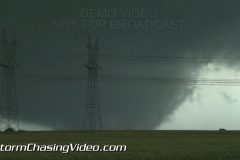
Footage of large multi-vortex wedge-shaped tornado, two tornadoes down simultaneously, long-track tornado, violent supercell thunderstorm, large hail, and dramatic lightning in northern Texas. The tornadoes occurred between Decatur and Denton Texas near the small towns of Bluett and Bolivar.
All footage shot in evening daylight (night lightning) on May 7, 2015 near Bluett and Bolivar, TX.
Shot List:
1-5. various shots of large wedge-shaped tornado west of Bolivar, TX
6-10. various shots of multiple vortex tornado/wedge-shaped tornado west of Bolivar, TX
11. shot of large wedge-shaped multi-vortex tornado north of Bluett, TX
12. wide/panning shot of 2 tornadoes: rope tornado panning to large multi-vortex wedge-shaped tornado north of Bluett, TX
13. pushed-in shot of multiple vorticies with large tornado near Bolivar, TX
14 & 15. wide POV driving shot of large wedge-shaped tornado north of Bluett, TX
16. pushed-in shot of cone tornado north of Bolivar, TX
17. wide POV driving shot of large wedge-shaped tornado near Bolivar, TX
18. pushed-in shot of rotating rain bands with tornadic supercell thunderstorm
19. pushed-in shot of large hail falling and bouncing in Boyd, TX
20-31. various shots of dramatic close lightning strikes near Sanger, TX
Wednesday May 6, 2015, Covering severe weather from Kansas to Nebraska. Live severe weather coverage embedded in the storm as SPC has enhanced risk for tornadoes.
StormChasingVideo.com LLC no longer handles the Rights and Clearances for this footage.
To license this footage, contact stormtrackerben@gmail.com
Copyright 2015 LiveNewsVideoNetwork.com
*** NO THIRD PARTY USE W/O LICENSE ***
SID=BenM
TVID=TBD
Baseball size hail storm in Rising Star, TX, wall cloud approaching town
SID=BenM
StormChasingVideo.com LLC no longer handles the Rights and Clearances for this footage.
To license this footage, contact stormtrackerben@gmail.com
Visitor’s to the strip in Las Vegas were greeted by strong winds and a dust storm
The winds were out of the southwest and have been blowing around 25 to 35 miles an hour with occasional strong wind gusts in the upper 40 miles per hour range at McCarran International Airport.
The Las Vegas valley is under wind and dust advisories until 11 p.m. Tuesday.
Clip 1 Large flag and palm trees blowing in the high winds.
Clip 2 Driving north on the south end of The Strip, high winds and blowing dust covers Las Vegas Blvd.
Clip 3 – 4 Looking north along Las Vegas Blvd at the city is covered in the haze and dust. Only the nearest buildings are visible.
Clip 5 A couple that were just married at Welcome to Las Vegas sign with the high winds.
Clip 6 Woman standing in the strong winds at the sign.
Clip 7 Another couple posing at the sign in the winds.
Clip 8 POV Driving on The Strip in the dust storm and low visibility.
Clip 9 Palm Tree’s blowing in the wind.
Clip 10 Looking south from the north end of the strip as everything is covered in the dust and non of the landmarks of the skyline are visible.
Clip 11-13 Palm trees blowing in the wind.
Clip 14-15 POV driving south on The Strip in the dust storm where you can only see the nearest landmarks.
Clip 16 Looking up at the sun, and only able to see haze as the tree’s and bushes below blow around.
Severe storms flipped semi trucks on both sides of interstate 80 today just after 5 PM. Durrant, Iowa fire department officials responded along with the Iowa State patrol. Only minor injuries were reported. The trucks were believed to have been flipped by the beginning stages of the tornado that later impacted the cities of Dewitt and Clinton, Iowa.
SID=BenM
StormChasingVideo.com LLC no longer handles the Rights and Clearances for this footage.
To license this footage, contact stormtrackerben@gmail.com
Live GPS Tracking: http://goo.gl/H9SmR7
Simon Brewer and Juston Drake are out chasing from Missouri and on into Illinois today for the Tornado Watch. Thursday April 9, 2015.
Copyright 2015 StormChasingVideo.com & LiveNewsVideoNetwork.com
*** NO THIRD PARTY USE W/O LICENSE ***
*** Contact StormChasingVideo.com for Licensing ***
SID=JustonD
TVID=TBD
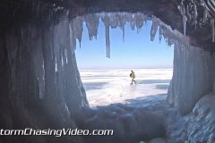
B-Roll footage of the start of the opening of the Apostle Island National Park Ice Caves.
For a second year in a row, the Apostle Islands Ice Caves are open to the public while the cold weather and ice conditions permit them to be safety accessed. However, it is a pretty tricky walk for over a mile on slippery ice conditions that are more like walking on a hockey rink.
Clip 1 Sign for Meyers Beach parking.
Clip 2 POV shot form inside a cave looking out
Clip 3 Ice formations inside a cave
Clip 4 Ice formations inside a cave
Clip 5 Two woman walking with a Selfie Stick and a pull back shot to a hole in the cave wall.
Clip 6 Ice formations from inside one of the many caves.
Clip 7 Close up ice formations
Clip 8 Interview with two women, Isabella Mcgarry and Megan Phillips about the ice caves.
Clip 9 Interview with Sean Gmora
Clip 10 – 29 Various shot in and out of the ice caves.
Clip 30 – 34 Interview with Park Ranger David Cooper.
Clip 35 – 91 More in and out of the ice caves B-Roll footage.
The video posted to our Youtube Channel is NOT sponsored and Youtube Advertising deems storm chasing and natural disaster videos as not advertiser friendly. If you would like to support us, click on the link below to visit our merchandise store.
http://www.stormchasingvideo.com/scv-merch-store/
Package shot in Jefferson County in and around the town of Mt. Vernon in southern Illinois. Mt. Vernon is at the junction of Interstates 57/64 approximately one hour east of St. Louis.
A major winter storm is hammering southern Illinois where WINTER STORM WARNINGS are in effect overnight for freezing rain and accumulating ice as well as snow and sleet. Parts of the region have seen as much as 0.30″ ice accumulation which has lead to accidents and extremely dangerous driving conditions. The storm will continue its winter barrage until late morning when it will change over to rain and become a flood threat as heavy rains, up to 3-inches possibly, will fall on ice-packed snow and frozen ground, leading to excessive runoff and potential for flooding across southern Illinois.
Footage shot between 10pm and 1am Friday night into Saturday morning in Jefferson County, IL and the town of Mt. Vernon.
Scene 1: NAT from Mike Ellis describing his drive from Nashville, TN to Mt. Vernon. Enroute, he accumulated over an inch of ice on his front of his car.
Scene 2-5: Various shots of the front of Mike Ellis’s car with ice accumulated on the front and mirrors.
Scene 6-7: Mike Ellis picks ice off the car before hitting the road from Mt. Vernon.
Scene 8: POV driving shot passing an accident with cops on scene along I-57 just to the south of Mt. Vernon in Jefferson County.
Scene 9-11: Various shots of accident along I-57 south of Mt. Vernon in Jefferson County.
Scene 12-15: Various shots of a jack-knifed semi off the side of the westbound lanes of I-64 to the west of Mt. Vernon in Jefferson County.
Scene 16-18: Shots of a plow truck dumping salt on I-64 in Jefferson County before the main brunt of the ice hit.
Scene 19-20: Shots of ice-covered parking lot in Mt. Vernon.
Scene 21-22: Woman scraping her car of ice in Mt. Vernon.
Scene 23: Man scraping his car of ice in Mt. Vernon.
Scene 24-25: Man scraping ice from his pickup truck in Mt. Vernon.
Scene 26-28: Shots of countless semis parked at a truck stop overnight as the freezing rain pours down.
Scene 29-30: Shots of antennas on the top of a car bent and frozen in a quarter-inch of ice in Mt Vernon.
Scene 31: Shot of a windshield and wipers covered in a layer of a quarter inch of ice in Mt Vernon.
Scene 32-33: Ice covering branches of a small tree in Mt Vernon.
Scene 34: Oncoming car’s headlights illuminates ice-covered road at an overpass south of Mt Vernon.
Scene 35: I-57 highway sign pointing the way to Mt Vernon as a car passes.
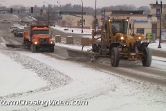
A quick blast of freezing rain and snow hit the upper Midwest of central Minnesota to create slick roads and dangerous driving conditions.
Footage from around the Saint Cloud, MN metro area.
Clip 1 Snow plow and road grader clearing snow on 9th Avenue.
Clip 2 Heavy snow and traffic on county road 75.
Clip 3 Tight shot of a ice on the front of a truck.
Clip 4 – 9 B-Roll clips of a smashed up car with police responding.
Clip 10 – 14 B-Roll clips of a crashed fuel truck on Highway 23.
Clip 15 Snow plow moving towards the camera.
Clip 16 Tight shot of a snow plow blade clearing snow.
Clip 17 Tight shot of a salt spreader dumping salt on the ground.
Clip 18 POV Following snow plow.
Clip 19 Tight shot of a snow plow blade clearing snow.
Clip 20 POV Following snow plow.
Clip 21 B-Roll of snow falling with trees.
Clip 22 – 24 POV Traffic driving in snow.
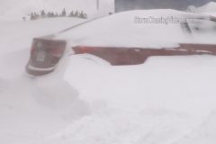
Footage of 31 inches of snow in Hudson, MA causing significant travel problems from Nor’easter Blizzard! Footage of measuring 31 inches of deep snow (one of the deepest measure snow depth in on of hardest hit areas of New England. Footage of frontloader/plow stuck in deep snow on I-495, car stranded, “snow sculptures” on buried cars, snowman, buried houses in Hudson, NY. Travel ban still in effect with blizzard warnings for region as Nor’easter blizzard of 2015 rides up New England Coast.
All footage shot during morning & afternoon of January 27, 2015 in/near Hudson, MA including I-495.
1-4. Various shots of stranded car damaged from sliding off I-495 with police assistance & wrecker
5-7. Various shots of stranded plow/front loader in deep snow ditch on I-495 with another plow & people attaching tow chain to free truck
8. Wide shot of front of house nearly buried in deep snow drifts
9. pushed-in shot of front door nearly buried in deep snow
10. wide shot of side of house with deep snow on roof & blocking door
11. pushed-in shot of deep snow drifts blocking entrance to house
12. pushed-in shot showing only very top of door with deep snow drift blocking entry
13. wide shot of “snow sculptures” on buried car with blowing snow from high winds
14. pushed-in shot of several buried cars with wiper blades extended
15. pushed-in shot of buried car
16. wide shot of buried car
17. pushed-in shot of buried SUV
18. wide shot of snowman in front of half buried house
19. pushed-in shot of snowman
20. pushed-in shot of front of half buried house
21. wide shot of Meteorologist Simon Brewer measuring 31 inch deep snow in woods with double yard stick walking in deep snow
22. wide shot of Meteorologist Simon Brewer measuring 31 inch deep snow in woods in Hudson, MA with double yard stick walking in deep snow
23. pushed-in shot of double yard stick plunging into 31 inch deep snow in Hudson, MA
24-29. various shots of people walking and/or shoveling deep snow in Hudson, MA
30 & 31. POV driving shots of snow plows on I-495 with heavy snow falling & near white out conditions
32. wide driving shot of very heavy snow falling on I-495 with trees in background
33. pushed-in shot of “Hudson” town sign
34. pushed-in driving shot of “Travel Ban” electronic sign on I-495 with deep snow piles lining highway and heavy snow falling
New footage from one of the last flights into Boston, MA last night to get ready for the storm and head to the coast for this historic storm.
The video is in two parts, the first part from the empty Boston Logan Airport with various clips of with virtually nobody in it.
The second part is from the Hull, MA area around the city and coastal areas.
Shot 1: Wide shot of people looking at cancelled flights in BOS airport
Shot 2: Closeup shot of cancelled flights
Shot 3: Medium shot of a bunch of de icing trucks at BOS
Shot 4: Empty security lines in BOS
Shot 5: Empty United ticketing counter at BOS
Shot 6: Closed due to Blizzard sign at restaurant
Shot 7: Heavy traffic with light snow falling
Shot 8: People coming through security in BOS
Shot 9: Boston street department clearing sidewalks
*** The folling footage is from around Hull, MA City and Coastline areas.
Shot 10: Empty I93 with travel ban sign + heavy snow
Shot 11: Violent winds + snow destroying street sign
Shot 12: Wide shot of snow plus boats
Shot 13: Tight shot of traffic lights being blown around
Shot 14: Mid shot of boats
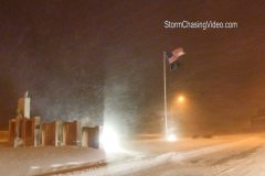
Shot 15: Flag whipping violently in wind + snow
Shot 16: Sign being blown by wind
Shot 17: House on coast all shuttered up
Shot 18: 3 snow plows work together to clear snow
Shot 19 More street lights being blown + snow
Shot 20: Whiteout conditions
Shot 21: Sign being blown in wind
Shot 22: Ocean (low light shot)
Heavy snowfall rates caused a 15+ car pileup that shut down I-80 westbound just east of Des Moines, Iowa.
Shot 1: Wide shot of vehicles scattered all across highway
Shot 2: Close up of firefighters attending to victims inside car.
Shot 3: Pan to include vehicles not shown in wide shot
Shot 4: Firefighters and law enforcement on crash scene
Shot 5: Multiple Vehicles slid into ditch and pan towards rest of scene
Shot 6: State Patrol vehicle making his way to crash scene on closed interstate
Shot 7: Single car accident on I-80
Shot 8: Flag blows in heavy snowfall
Shot 9: Man cleaning off windshield
Shot 10: Man plows parking lot with ATV
Shot 11: Plow pushes snow on highway
Shot 12: Landscaping with heavy snowfall
Video Footage featuring the Dangerous and Intense Ground Blizzard Conditions occurring over Northwest Minnesota with Max wind speeds of up to 50MPH creating True Zero Whiteout conditions making travel dangerous and near Impossible in open country!
Video Footage Includes:
1. Minnesota Border Entry and high Winds
2. Polk County Minnesota road signs nearly shaking off their bases in 55MPH wind gusts!
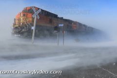
3. BNSF Freight Train fighting the Intense Ground Blizzard and over 50MPH wind gusts and near zero visibility near Fisher Minnesota.
5. Very high wind gusts creating ground blizzard conditions as travelers maneuver the low visibility.
6-8 Ground Blizzard Conditions with extreme wind gusts!
9-12. Zero visibility driving on MN US Hwy 2 near Crookston.
13. Man Fighting back Snow drifts with a heavy snow blower
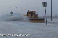
14. MNDOT Snowplow pass by in blowing snow
Video Package highlighting the Severe Blizzard Conditions from the Blizzard Warning areas of Eastern North Dakota near and north of Grand Forks ND. Video package includes several clips of footage featuring Plowing and heavy snow drift cutting, People walking in 50MPH winds with blinding snow and zero visibility.
Footage includes shots of dangerous driving conditions and extreme winds of 50MPH with heavy blowing snow impacting all forms and modes of travel!
To license this footage, visit http://www.StormChasingVideo.com
Highlights from the 25th Annual Polar Plunge on Lake Minnetonka, in Excelsior MN.
Footage includes various clips of people jumping into the frigid water in the whole that was cut into Lake Minnetonka for the 25th year of the historic Polar Plunge.
The Polar Plunge is an annual event to celebrate New Years Day.
https://www.alarc.com/alarc-ice-dive.html