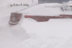
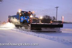
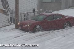
Footage of 31 inches of snow in Hudson, MA causing significant travel problems from Nor’easter Blizzard! Footage of measuring 31 inches of deep snow (one of the deepest measure snow depth in on of hardest hit areas of New England. Footage of frontloader/plow stuck in deep snow on I-495, car stranded, “snow sculptures” on buried cars, snowman, buried houses in Hudson, NY. Travel ban still in effect with blizzard warnings for region as Nor’easter blizzard of 2015 rides up New England Coast.
All footage shot during morning & afternoon of January 27, 2015 in/near Hudson, MA including I-495.
1-4. Various shots of stranded car damaged from sliding off I-495 with police assistance & wrecker
5-7. Various shots of stranded plow/front loader in deep snow ditch on I-495 with another plow & people attaching tow chain to free truck
8. Wide shot of front of house nearly buried in deep snow drifts
9. pushed-in shot of front door nearly buried in deep snow
10. wide shot of side of house with deep snow on roof & blocking door
11. pushed-in shot of deep snow drifts blocking entrance to house
12. pushed-in shot showing only very top of door with deep snow drift blocking entry
13. wide shot of “snow sculptures” on buried car with blowing snow from high winds
14. pushed-in shot of several buried cars with wiper blades extended
15. pushed-in shot of buried car
16. wide shot of buried car
17. pushed-in shot of buried SUV
18. wide shot of snowman in front of half buried house
19. pushed-in shot of snowman
20. pushed-in shot of front of half buried house
21. wide shot of Meteorologist Simon Brewer measuring 31 inch deep snow in woods with double yard stick walking in deep snow
22. wide shot of Meteorologist Simon Brewer measuring 31 inch deep snow in woods in Hudson, MA with double yard stick walking in deep snow
23. pushed-in shot of double yard stick plunging into 31 inch deep snow in Hudson, MA
24-29. various shots of people walking and/or shoveling deep snow in Hudson, MA
30 & 31. POV driving shots of snow plows on I-495 with heavy snow falling & near white out conditions
32. wide driving shot of very heavy snow falling on I-495 with trees in background
33. pushed-in shot of “Hudson” town sign
34. pushed-in driving shot of “Travel Ban” electronic sign on I-495 with deep snow piles lining highway and heavy snow falling
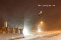
New footage from one of the last flights into Boston, MA last night to get ready for the storm and head to the coast for this historic storm.
The video is in two parts, the first part from the empty Boston Logan Airport with various clips of with virtually nobody in it.
The second part is from the Hull, MA area around the city and coastal areas.
Shot 1: Wide shot of people looking at cancelled flights in BOS airport
Shot 2: Closeup shot of cancelled flights
Shot 3: Medium shot of a bunch of de icing trucks at BOS
Shot 4: Empty security lines in BOS
Shot 5: Empty United ticketing counter at BOS
Shot 6: Closed due to Blizzard sign at restaurant
Shot 7: Heavy traffic with light snow falling
Shot 8: People coming through security in BOS
Shot 9: Boston street department clearing sidewalks
*** The folling footage is from around Hull, MA City and Coastline areas.
Shot 10: Empty I93 with travel ban sign + heavy snow
Shot 11: Violent winds + snow destroying street sign
Shot 12: Wide shot of snow plus boats
Shot 13: Tight shot of traffic lights being blown around
Shot 14: Mid shot of boats
Shot 15: Flag whipping violently in wind + snow
Shot 16: Sign being blown by wind
Shot 17: House on coast all shuttered up
Shot 18: 3 snow plows work together to clear snow
Shot 19 More street lights being blown + snow
Shot 20: Whiteout conditions
Shot 21: Sign being blown in wind
Shot 22: Ocean (low light shot)
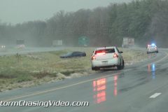
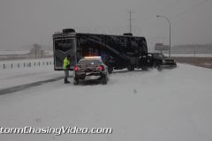
Heavy snowfall rates caused a 15+ car pileup that shut down I-80 westbound just east of Des Moines, Iowa.
Shot 1: Wide shot of vehicles scattered all across highway
Shot 2: Close up of firefighters attending to victims inside car.
Shot 3: Pan to include vehicles not shown in wide shot
Shot 4: Firefighters and law enforcement on crash scene
Shot 5: Multiple Vehicles slid into ditch and pan towards rest of scene
Shot 6: State Patrol vehicle making his way to crash scene on closed interstate
Shot 7: Single car accident on I-80
Shot 8: Flag blows in heavy snowfall
Shot 9: Man cleaning off windshield
Shot 10: Man plows parking lot with ATV
Shot 11: Plow pushes snow on highway
Shot 12: Landscaping with heavy snowfall
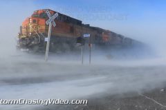
Video Footage featuring the Dangerous and Intense Ground Blizzard Conditions occurring over Northwest Minnesota with Max wind speeds of up to 50MPH creating True Zero Whiteout conditions making travel dangerous and near Impossible in open country!
Video Footage Includes:
1. Minnesota Border Entry and high Winds
2. Polk County Minnesota road signs nearly shaking off their bases in 55MPH wind gusts!
3. BNSF Freight Train fighting the Intense Ground Blizzard and over 50MPH wind gusts and near zero visibility near Fisher Minnesota.
5. Very high wind gusts creating ground blizzard conditions as travelers maneuver the low visibility.
6-8 Ground Blizzard Conditions with extreme wind gusts!
9-12. Zero visibility driving on MN US Hwy 2 near Crookston.
13. Man Fighting back Snow drifts with a heavy snow blower
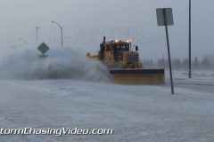
14. MNDOT Snowplow pass by in blowing snow
Video Package highlighting the Severe Blizzard Conditions from the Blizzard Warning areas of Eastern North Dakota near and north of Grand Forks ND. Video package includes several clips of footage featuring Plowing and heavy snow drift cutting, People walking in 50MPH winds with blinding snow and zero visibility.
Footage includes shots of dangerous driving conditions and extreme winds of 50MPH with heavy blowing snow impacting all forms and modes of travel!
To license this footage, visit http://www.StormChasingVideo.com
Highlights from the 25th Annual Polar Plunge on Lake Minnetonka, in Excelsior MN.
Footage includes various clips of people jumping into the frigid water in the whole that was cut into Lake Minnetonka for the 25th year of the historic Polar Plunge.
The Polar Plunge is an annual event to celebrate New Years Day.
https://www.alarc.com/alarc-ice-dive.html
GPS Tracking URL: http://goo.gl/AckeL6
Live streaming video at the 25th annual Lake Minnetonka Polar Plunge event January 1, 2015 starting at 7:30am CDT. Video of people jumping into a hole cut into the lake on New Years Day with expected air temperature around 15F.
*** NO THIRD PARTY USE W/O LICENSE ***
Copyright 2015 StormChasingVideo.com
Contact StormChasingVideo.com for Licensing
SID=DougK
Video Package Highlighting the large cleanup efforts ongoing in the Minneapolis/St.Paul region following the areas first Major Winter Snow Storm overnight that dropped 4-10 inches of Heavy Wet Snow.
Video Footage Includes:
1. Close Minneapolis Snow Plow Pass By.
2. Close Snow Plow Approaching.
3. Snow Plows Gang Plowing In Minneapolis with Heavy Snow.
4. Snow Plows from behind with heavy salt spinners and dropping salt with blade down.
5. Gang Plow follow behind POV.
6. Tractors blading snow.
7. People shoveling and snowblowing heavy wet snow.
8-9 – Man snow shoveling the heavy wet snow wide and tight with backlight.
10. Cars burried in deep snow.
11. Man air jetting snow off of cars.
12. Workers struggle to get shopping carts back into the mall and spinn the tires over and over and slip out!
13. People cleaning snow off of cars.
Raw footage from the historic Pilger,, Nebraska multiple tornadoes that was streamed live on several television networks.
Footage from the dash camera as the storm forms and continues through the life cycle as it moves over the town of Pilger and off to the northeast.
Catalog ID: 06162014_BM1
Total Run Time: 43:46:09
SID: Brennan Jontz / Ben McMillan
StormChasingVideo.com LLC no longer handles the Rights and Clearances for this footage.
To license this footage, contact stormtrackerben@gmail.com
Massive, violent wedge tornado near El Reno, OK on 5/31/2013 approximately from 5:30 PM until 6:15 PM CDT.
Footage continues as the videographers take shelter from the violent storm at the Oklahoma City Airport.
Catalog ID: 05312013_SR_ENG
Total Run Time: 09;30;29
To license this footage, visit http://www.StormChasingVideo.com
Footage of powerful Nor’easter hitting Upstate New York Catskills with heavy snow, high winds, and flooding rains. Footage of heavy snow causing problems on I-88 & in Cobleskill, NY. Winter storm warnings are in place for the region, including Cobleskill, where a foot or more of snow is expected over the next 2 days.
All footage clips shot during evening of December 9, 2014 at dark in/near Cobleskill, NY.
Shot List:
1. Pushed-in shot of “Watch for Ice, Next 14 Miles” sign in foreground with emergency vehicle assisting stranded vehicle in background with heavy snow falling
2. pushed-in driving shot of “Cobleskill” highway sign with heavy snow falling
3-5. various shots of people walking in very heavy snow in Cobleskill, NY
6-11. various shots of vehicles driving past camera with very heavy snow falling
7. pushed-in shot of wreath & Christmas decorations on light pole with heavy snow falling in Cobleskill, NY
8. pushed-in shot of Christmas lights in park with heavy snow falling in Cobleskill, NY
9. wide shot of Cobleskill town Christmas Tree with heavy snow falling
10. pushed-in shot of Cobleskill Police Patrol vehicle in foreground with town Christmas Tree in background with heavy snow falling
11 & 12. pushed-in shots of heavy snow falling with traffic in decorated downtown Cobleskill, NY
13-17. various shots of snowplows clearing accumulated snow with heavy snow falling
18. pushed-in shot of rain/snow mix falling around street light as heavy rain changes to snow
19-25. various shots of heavy snow falling
26. pushed-in shot of heavy snow accumulating on grass
27-32. various POV driving shots with heavy snow falling on Interstate 88 Traffic near Cobleskill, NY
Freezing rain fell overnight and into the morning across southern Illinois where a FREEZING RAIN ADVISORY remained in effect until 6pm Monday. A light glazing of ice, generally in the 0.10-0.15″ range (per the Paducah NWS office), coated trees and cars, as well as created some slick spots leading to spin-outs on area highways. The warmer surfaces prevented a more significant event from unfolding, but it was still enough to cause some minor issues and bring out the snow plows.
Video package shot in Williamson County in southern Illinois near the towns of Marion and Herrin. This is approximately 2 hours south/southeast of St. Louis.
Scene 1: Establishing shots of the icy Williamson County sign with a snow plow turning onto the road directly behind the sign.
Scene 2: Close shot of the Williamson County sign with icicles hanging from the sign.
Scene 3: Wider shot of the icy Williamson County sign.
Scene 4: POV driving shot approaching an accident on I-57 north of Johnston City as a Ford Mustang spun off the highway into the center median.
Scene 5: Wide shot looking down from an overpass of the Mustang accident scene as one cop pulls up next to another patrol vehicles.
Scene 6: Shot of the Mustang in the median with southbound traffic behind it.
Scene 7: Shot of Mustang in the median.
Scene 8: Wide shot looking at the accident scene with northbound traffic flowing behind.
Scene 9: POV drive shot of a snowplow dumping salt onto an I-57 bridge near Marion.
Scene 10: POV driving shot behind a snowplow on I-57 approaching Marion.
Scene 11: POV driving shot of oncoming snowplow.
Scene 12: Panning shot of oncoming snowplow on a Williamson County highway.
Scene 13: Shot on an I-57 overpass showing the road conditions as a Jeep drives through the shot.
Scene 14: Shot of falling sleet bouncing with blurry highway background.
Scene 15-16: Shot of ice on pine needles with passing traffic in the background.
Scene 17-18: Shot of ice on tree branches.
Scene 19-20: Shots from interior of vehicle as windshield wipers scrape across ice on windshield.
Scene 21: Shot of rolling down a window with the ice collecting at the door frame.
To help support our freelancers, buy them coffee. https://www.buymeacoffee.com/stormchasing/
To License This Footage For Broadcast, Contact Video @ StormChasingVideo.com
Our Team Merch Store – https://stormchasingvideo.creator-spring.com
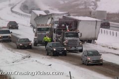
The storm system that dropped up to a half a foot of new snow in southern Minnesota also caused a nightmare on the roads as dozens of accidents were reported just between Faribault, MN and Owatonna, MN.
Clip 1 Heavy snow falling along Interstate 35 with traffic at a stand still near Medford, MN
Clip 2 POV Driving in heavy snow
Clip 3 POV Driving in heavy snow
Clip 4 – 9 Several shots of Semi Trucks wrecked and blocking northbound Interstate 35 just north of Medford, MN.
Clip 10 Snow plow trying to make it through to clear the road for emergency traffic.
Clip 11 Southbound Interstate 35 traffic backed up and at a stand still.
Clip 12 State Trooper trying to get to an accident in the massive traffic jam on southbound I35.
Clip 13 Tow truck in heavy snow with a car that was in an accident.
Clip 14 Sheriff on the scene of several accidents at I35 and the Medford, MN exit.
Clip 15 Deputy walking past several wrecks.
Clip 16 Car in the ditch.
Clip 17 Deputy talking to one of those in the pile up.
Clip 18 Wider shot of car in the ditch up against the barbed wire fence.
Clip 19 Tow truck hauling off a crashed vehicle as another one sits on the side of the road at the exit.
Clip 20 Cars crashed on the side of I35
Clip 21 Crashed SUV on I35
Clip 22 Crashed vehicle and state patrol on the middle of northbound I35
Clip 23 Wrecked vehicle in the middle of I35
Clip 24 Wide shot of Vehicle and trooper on I35
Clip 25 Tight shot of the smashed front end.
Clip 26 Heavy snow and stop sign
Clip 27 POV Driving shot heading southbound with all the traffic backed up heading north.
Clip 28 Heavy snow and trees.
Footage of record-breaking lake effect snow band from Lake Erie continuing to bury areas of western New York including town of Lockport.
Whiteout conditions in very heavy snow band creating dangerous traveling conditions.
All footage shot during daylight on morning of November 19, 2014 in Lockport, NY
1.Pushed-in shot of Several National Guard HUMV vehicles in heavy falling snow
2. Pushed-in shot of mother & child crossing snow-covered road with heavy snow falling
3. Pushed-in shot of snowplow clearing road with heavy snow falling
4. Pushed-in shot of woman entering car with heavy snow falling
5. POV shot of traffic with very heavy snow falling
6. pushed-in shot of traffic passing with near white-out visibility
7. pushed-in shot of whiteout conditions in heavy snow
8. pushed-in shot of “Erie Canal” road sign with very heavy snow falling
9. pushed-in shot of traffic light with heavy snow falling
10-26. various shots of traffic passing with very heavy snow falling in whiteout conditions at times
To help support our freelancers, buy them coffee. https://www.buymeacoffee.com/stormchasing
Amazing footage of the Winter Storm as it impacts Duluth, Minnesota causing dangerous road conditions, which resulted in multiple accidents in the area.
Shot 1:Car slides down hill over curb and into light pole, breaking front bumper cover.
Shot 2:Car slides down hill and hops curb
Shot 3:Car slides down hill and hops curb
Shot 4:Car slides down hill sideways
Shot 5:Car slides down hill sideways
Shot 6:Car struggles getting traction on steep hill
Shot 7:Van slides down hill over curb and honks to warn drivers
Shot 8:Car slides down hill and almost hits stop sign
Shot 9:Car cant make climb up hill and turns around
Shot 10:”Winter Conditions Reduce Speed Use Caution” on interstate signs
Shot 11:Snow plow cleaning area streets
Shot 12:Heavy snow obstructs view of the Aerial Lift Bridge
Shot 13:Flags blowing in high winds
Shot 14:Beautiful snow covered road
To license this footage, visit http://www.StormChasingVideo.com
As the major winter storm slams Minnesota, Saint Cloud picked up over 13 inches of snow today. Roads were impacted heavily with ice and snow which made for dangerous driving conditions.
Clip 01 Snow plow moving towards the camera from a overhead bridge.
Clip 02 POV shot with VO talking about the storm.
Clip 03 Driving in whiteout conditions with VO about it.
Clip 04 – 10 Interstate 94 shut down due to a jack knife trail.
Pull back shot of all the traffic backed up.
Woman cleaning the wiper blades
State Patrol on the scene of the wreck
Another car in the ditch next to the jack knife
Tight shot of the state patrol and the trailer
Wide shot of the whole scene
Wider shot of the whole scene
Clip 10 Wide shot passing a snow plow.
Clip 11 Pan shot right of a truck in the ditch
Clip 12 – 13 Truck spinning it’s wheels
Clip 14 Snow Plow
Clip 15 Car stuck in the snow.
Clip 16 Sign falling apart in the winds and snow
Clip 17 Blowing snow across a field
Clip 18 Blowing snow across the Stick Works sculpture at Saint Johns University.
Clip 19 Car stuck in the ditch
Clip 20 Car stuck in the ditch
Clip 21 Truck stuck in the ditch
Clip 22 POV shot of blowing snow on Interstate 94
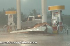
Powerful severe thunderstorms cause widespread damage over North Texas. Footage of severe winds blowing debris, powerflashes, damaged gas station, fallen trees, and damaged home and ranches, cleanup crew, frequent lightning, fire caused by lightning, and a double rainbow in and near Sulphur Springs, TX.
All shots taken during daylight on evening of October 2, 2014 in or near Sulphur Springs, TX
1. POV driving shot of severe thunderstorm shelf cloud bearing down on Sulpher Springs, TX
2. pushed-in shot of blowing debris and bending flag from severe high winds
3. pushed-in shot of powerflash behind shaking stop sign with blowing debris
4. pushed-in shot of blowing power lines with blowing debris
5-9. various shots of close lightning bolts
10. POV driving shot of heavy rain, hail, & high winds
11. POV driving shot pulling into damaged gas station from severe winds
12-14. various shots of wind-damaged sign hanging in wind with lightning flashes
15-26. various shots of damage caused by severe winds to gas station in Sulphur Springs, TX
27 & 28. various shots of fallen tree over highway near Sulphur Springs, TX
29. pushed-in shot of emergency crew clearing debris from highway near Sulphur Springs, TX
30 & 31. Various shots of trampoline overturned next to road blown over 100 meters by severe winds
32 & 33. various shots of grain bin tossed over road from severe winds
34 & 35. various shots of large fallen tree on top of Recreational Vehicle (RV)
36-38. various shots of barn wild fire supposedly caused by lightning
39 & 40. Various shots of rainbow near sunset behind line of thunderstorms near Sulphur Springs, TX
41. wide shot of dramatic stormy sky behind line of severe thunderstorms near Sulphur Springs, TX
42. pushed-in shot of “Sulphur Springs” highway city sign in Sulphur Springs, TX
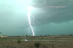
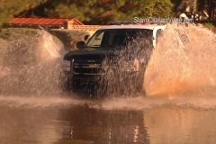
A powerful line of severe storms pounded the Phoenix, AZ Metro area this afternoon with damaging high winds, heavy rains and flash flooding.
Footage shot on the west side of Phoenix, AZ.
Clip 1 Transformers or power lines exploding at 35th and McDowell in Phoenix while looking to the west.
Clip 2 Slow motion and cropped HD footage of the transformer and power lines exploding as debris hits them.
Clip 3 Vivid Cloud to ground lightning at I-10 and Jackrabbit Trail looking west over the city of Buckeye.
Clip 4-6 Dramatic storm clouds west of Phoenix as the severe storms moved into the area.
Clip 7 Pulled over on I-10 due to heavy rain and high water on the interstate.
Clip 8 Wall cloud moving into the Phoenix, AZ area.
Clip 9 High winds blasting the area at I-10 and 35th Avenue.
Clip 10 Traffic on I-10 in the middle of the storm.
Clip 11-12 High winds blasting the area and slamming the trees.
Clip 13 POV shot of driving in the heavy rain on I-10
Clip 14 POV shot of driving in the heavy rain on I-10
Clip 15 POV shot of driving in the heavy rain and flooded roadway on I-10
Clip 16 POV shot of people driving through flooded out roads.
Clip 17 – 18 Heavy rain falls on Interstate 10. Biker waits out the rain under an overpass.
Clip 19 – 22 Traffic driving through the flooded streets of Phoenix, AZ.
Clip 23 The rain and flooding was so heavy, it blew this man hole cover off the roadway.
Clip 24 – 27 Power is out to the stop lights and traffic is not sure what to do.
Clip 28 – 29 Debris on the roadway.
Clip 30 – 36 Trees down and storm damage
Clip 37 Wide shot of the storm over one of the mountains around Phoenix.
SID=BenM
StormChasingVideo.com LLC no longer handles the Rights and Clearances for this footage.
To license this footage, contact stormtrackerben@gmail.com
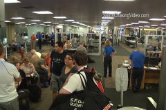
Footage form inside Phoenix, AZ Sky Harbor Airport beyond the security check point while waiting to fly back after chasing the remnants of Hurricane Odile in southeastern Arizona on Wednesday.
One of the busiest airports in the country was locked down Thursday afternoon due to a Tempe, AZ shooting prompted a pursuit that led to the airport.
Passengers that who just arrived to the Sky Harbor were not allowed to leave the gate area and security was not telling anyone what was happening. Several thousand people also were bumped from their connecting flights as dozens of flights were canceled after the several hour delay.
Clip 1 Pan shot of the exit area inside Terminal 4 shut down and nobody was allowed to leave. Great Audio of what was being told to everyone over the loud speakers.
Clip 2 Security check point locked down and nobody coming into the terminal
Clip 3 Low shot of one of the check points locked down.
Clip 4 Passengers trying to leave the airport stuck at the security check point as everyone was detained. Great Audio of what was being told to everyone.
Clip 5 Locked down security check point that would not let anyone into the terminal.
Clip 6 Interview with one of the ground crew workers telling me what was happening.
Clip 7 B-Roll of people just sitting around in the terminal waiting to find out when they can leave.
Clip 8 Pan shot right of the security check point and people waiting to leave the terminal
Clip 9 B-roll of people inside the airport that were force to stay there while waiting to leave the terminal
Clip 10 Airport workers were even forced to stay in place while waiting for the lock down to end.
Clip 11 Large group of people sitting around the airport terminal
Clip 12 B-Roll of the empty airport gates as all incoming flights were diverted.
Clip 13 Airport security check point locked down as workers stand around.
Clip 14 Passengers and flight crews standing around waiting to leave the terminal.
Clip 15 More passengers waiting to leave the terminal.
Clip 16 After several hours of waiting, passengers and staff were finally able to leave the airport terminal.
Clip 17 – 19 Footage of the Departures where several of them were now “Cancelled”.
Clip 20 B-roll of an Airplane finally being able to land after the lock down ended.
New extreme footage from the evacuation area in Mesa, AZ where over 100 homes were impacted by flooding after the rain stopped.
After the record breaking rain moved out of the Phoenix, AZ area, the flooding just begun to get worse for the City of Mesa, AZ which is located just east Phoenix, AZ.
The water in the Emerald Park neighborhood of Mesa, AZ kept rising until a evacuation for hundreds of homes that were now being impacted with the rising water from the run off.
Footage show dramatic scenes from inside the neighborhood while walking around in several feet of water.
Clip 1 Emerald Park sign with the submerged basketball courts in the back ground.
Clip 2 Mesa Police driving through the deep flood waters
Clip 3 Mutual Aide from the Gilbert Fire Department with a tight shot of the Gilbert GFD logo on the side of one of their trucks.
Clip 4 A woman walking through the flood waters towards the camera.
Clip 5 Kids playing on rafts in the flooded streets.
Clip 6 House with flood waters surrounding it.
Clip 7 House with flood waters surrounding it.
Clip 8 Woman walking in front of a house that is surrounded by flood waters.
Clip 9 Another house surrounded by flood waters.
Clip 10 Fire line tape with a woman standing behind it looking at the flooding to her neighborhood.
Clip 11 Pan right shot of the Mesa, AZ Public Information Officer SUV driving through the flood waters as the camera pans to where the water is rushing down the street.
Clip 12 Mesa, AZ fire truck and crew watching over the scene.
Clip 13 Major flooding with cars and a rental truck in the deep water.
Clip 14 Man pulls a boat behind him in the flood waters
Clip 15 Speed bump under the water makes for a area of rapids in the flooded out road.
Clip 16 Group of people evacuating their homes and carrying bags and suitcases.
Clip 17 – 18 Pickup truck carrying a bunch of people who are trying to go and get sandbags for their homes.
Clip 19 People walking by the Gilbert, AZ Fire Truck parked in the flooding.
Clip 20 A couple walking in the flooded road.
Clip 21 A group of kids standing in the flooded waters.
Clip 22 Three kids walking in the flooded waters.
Clip 23 Father and daughter in the flooded street.
Clip 24 Man walking his dog in the flood waters.
Clip 25 A woman sitting on a rock and watching the rising water.
Clip 26 A large group of people walking down the flooded our street.
Clip 27 People walking along the flooded out street and homes.
Clip 28 People walking along the flooded out street and homes.
Clip 29 Silver pickup truck driving in the flooded out road.
Clip 30 White pickup truck driving in the flooding.
Clip 31 Ambulance crews waiting outside of the flooded out area on standby.
Clip 32 City of Mesa Fire Command Truck.
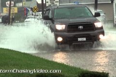
Strong storms put an end to the week-long heatwave across southern Illinois as Thursday was the first day in seven days where heat-related alerts were not in effect. However, the cooler weather came at the price of heavy rain as doppler radar estimates over 2 inches fell in less than an hour across many areas of southern Illinois, including in the city of Marion. Storms fired early in the afternoon and continued to form and slowly move across the region into the evening. The season opener for the Saluki College Football Team in nearby Carbondale went on as the storms cleared the area before kickoff.
Video package shot in Marion, Illinois on I-57 about 2 hours southeast of St. Louis in Williamson County.
Scene 1: POV shot looking east toward the storm over Marion with a lightning strike.
Scene 2: POV looking out windshield at a stop lightning that was flashing red, likely due to lightning strike.
Scene 3: Shot at two men pushing a pickup truck after it stalled out in high waters behind it.
Scene 4-5: POV shots driving through flooded roadway in Marion.
Scene 6: POV shot looking out window of traffic in flooded streets.
Scene 7: Pickup truck driving through flooded roads kicking up lots of water.
Scene 8: Oncoming truck splashing large amounts of water off flooded roads.
Scene 9: Long shot beginning with an oncoming school bus driving through flooded roads, followed by other oncoming traffic in the water.
Scene 10: Close shot of traffic driving away from the camera in the flooded streets.
Scene 11: Shots of two vehicles moving in opposite directions moving through flood waters.
Scene 12: Three vehicles driving across the frame through flooded streets.
Scene 13: Panning shot of oncoming truck drives through flood waters, moves off screen revealing opposite moving traffic driving through the flood waters.
Scene 14: Several vehicles driving through flooded streets.
Scene 15: Oncoming white car drives at camera through flooded streets.
Scene 16-17: Wide shots of flooded street with cars driving through it.
Scene 18: Utility truck driving at a camera through flooded streets.
Scene 19: Tighter shot of traffic in the flooded streets.
Scene 20: Oncoming pickup truck drives through flooded street in a Marion residential area.
Scene 21: Shot of flood waters in a yard with water up to the bumper of a pickup truck mostly blocked by home.
Scene 22: Shot of flood waters at Marion house.
Scene 23: Shot of flood waters up to the garage of a Marion home.
Scene 24: Shot looking into the backyard of a residence that is flooded with pieces of firewood floating in the water.
Scene 25: Panning shot of flood waters in a Marion yard.
Scene 26: Static wide shot of flooded Marion yard.
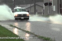
The first wave of rains moved into southern Illinois Thursday afternoon dropping over an inch in less than an hour in many places across the region. Several more rounds are expected through Friday night with even more rains and potential for flooding. August is typically one of the drier months in Illinois, and with another inch or two possible through Friday, this is highly unusual for this time of year in southern IL.
Marion recorded 1.36″ of rain in less than an hour as measured by the automated gauge at Marion Junior High School with this first round. It lead to the street flooding shown in this clip. Marion is 2 hours southeast of St. Louis in Williamson County.
Scene 1: POV drive shot following a vehicle into the street flooding.
Scene 2: Traffic driving in heavy rains and street flooding.
Scene 3: Traffic driving through the street flooding in Marion during the heavy rain event.
Scene 4-5: Shots of oncoming traffic in the street flooding and heavy rains.
Scene 6: A bicyclist in traffic in the street flooding and heavy rain.
Scene 7-10: Various traffic shots during the rain storm in the street flooding.
Scene 11: Statis shot looking at one of the flooded neighborhood roads and yards.
Scene 12: POV drive shot on I-57 coming into Marion during the rain storm.
Scene 13-14: Motorcyclist in the rains shot POV on I-57 coming into Marion.
Scene 15: POV shot in heavy rains on I-57 in Marion.
Scene 16: POV shot in heavy rains in Marion.
Scene 17: Shot of a vehicle at an intersection during the rain.
Scene 18-20: Shots of rain against trees showing the intensity of the downpour.
Scene 21: Shot of moving traffic in the heavy rains.
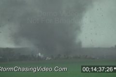
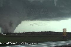
Raw video from the Pilger, Nebraska twin tornadoes.
SID=BenM
StormChasingVideo.com LLC no longer handles the Rights and Clearances for this footage.
To license this footage, contact stormtrackerben@gmail.com
Shot 1 Funnel Cloud near Rothsay, MN
Shot 2 Wall cloud near Barnesville, MN
Shot 3 Police car driving through damage in Deer Creek, MN
Shot 4 Culvert overflowing with water looking more like a rushing river. near Ottertail, MN
Shot 5 Whirlpool in a culvert near Ottertail, MN
shot 6 1 inch hail drifts along a building. in Deer Creek, MN
shot 7 Truck driving in damage and downed branches in Deer Creek, MN
shot 8 Car driving in hail fog near Ottertail, MN
shot 9 Shot of hail fog near Ottertail, MN
shot 10: Second shot of culvert with water gushing out of it on Ottertail County Highway 108.
shot 11: Close up shot of whirlpool in a culvert near Ottertail, MN