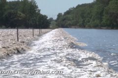
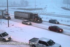
Footage of houses & farms under water, stranded fish, water rushing over highways & bridges, a large whirlpool, flowing debris & a temporary levee being built over Interstate 29 to protect Sioux City, IA as record flooding strikes the Big Sioux River along the Iowa & South Dakota border! A state of emergency is declared for South Dakota as a section of Interstate 29 in Southeast South Dakota is closed for several days & National Guard troops build a temporary levee over the Interstate highway to divert water over Interstate 29 away from North Sioux City as the Big Sioux River is expected to crest at a record 109 ft deep.
All shots during afternoon daylight on June 19, 2014 near Jefferson, SD & Sioux City, IA & North Sioux City, SD near Highway 3 & 12, and Interstate 29.
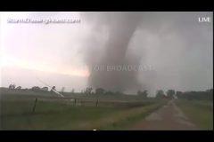
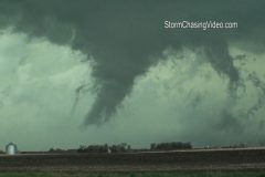
*** Incredible multi-vortex and large stove pipe tornadoes streamed live on June 18, 2014 ***
Doug Kiesling now in South Dakota tracking severe weather. Live severe weather coverage .
Live GPS tracking
http://www.livenewsvideonetwork.com/scvp/scv-stringers/doug-kiesling/live-track/
Copyright 2014 StormChasingVideo.com & LiveNewsVideoNetwork.com
*** NO THIRD PARTY USE W/O LICENSE ***
SID=DougK
TVID=TWC
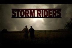
Juston and Simon (aka StormRiders) are on a severe thunderstorm in north east Nebraska near Harting NE. Live severe weather news video.
Live GPS tracking
http://www.livenewsvideonetwork.com/scvp/scv-stringers/juston-drake/live-track/
Copyright 2014 StormChasingVideo.com & LiveNewsVideoNetwork.com
*** NO THIRD PARTY USE W/O LICENSE ***
SID=JustonD
TVID=
Nick Elms and Amanda Hill are live tracking severe weather in the upper Midwest. Live severe weather coverage .
Live GPS tracking
http://www.livenewsvideonetwork.com/scvp/scv-stringers/nick-elms/live-track/
Copyright 2014 StormChasingVideo.com & LiveNewsVideoNetwork.com
*** NO THIRD PARTY USE W/O LICENSE ***
Contact StormChasingVideo.com for licensing.
SID=NickE
TVID=TWC
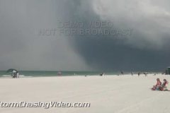
HD video. A SW flow causes reverse seabreeze where storms form in morning along the coast and move inland by afternoon. This is the reverse of the typical SE flow pattern where storms form inland then move to the coast in the afternoon. The morning storms caught some Siesta Key Beach goers by surprise and sent them scurrying for cover to take shelter from wind driven rain and lightning.
Shot list:
1) Wide shot of storm clouds over Siesta Key beach.
2) Leading edge of rain shaft and black clouds approaching beach with people on beach.
3) Family on beach looking up at sky.
4) Rainbow forms as rain shaft and storm clouds approach coast.
5) People in water as waves pick up with approaching storm.
6) Guy with green umbrella looks around as thunder rumbles.
7) Boat offshore with rainbow and thunder rumbles.
8) Small boat offshore racing for cover as storm and heavy rain approach.
9,10) Two shots of people running off beach as rain hits.
11) Beach parking lot with school bus in heavy rain and crashing thunder.
12) Heavy rain.
13) Parked SUV in heavy rain and thunder.
14) Dash cam shot with splashing traffic in heavy rain.
15,16) Two shots of downtown Sarasota skyline in rain and thunder with storm clouds.
17) Boat navigates markers on bay in rain.
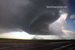
Footage of massive 4 inch diameter hail, intense close lightning strike, & awesome striated, mother-ship, tornado-warned supercell thunderstorm as it passed north of Roswell, NM. An area known for UFO’s experienced a once-in-a-lifetime “mothership” supercell thunderstorm.
All shots during daylight on June 7, 2014 near Roswell, NM
Shot List:
1. pushed-in shot of 4-inch diameter hail in hand northeast of Roswell, NM
2. wide shot of 3 & 4 inch diameter hailstones in hands northeast of Roswell, NM
3. wide shot of several 3 & 4 inch diameter hailstones with measuring ruler & comentary northeast of Roswell, NM
4. pushed-in shot of several 3 & 4 inch diameter hailstones with measuring ruler northeast of Roswell, NM
5. pushed-in shot from above of 4 inch diameter hailstone next to measuring ruler
6. pushed-in shot shot of large hail falling & bouncing on road & fence
7. pushed-in shot of large hail falling, bouncing, & accumulating on road
8. pushed-in shot of large hail falling & bouncing in grass next to road
9. ultra-wide driving shot of large hail falling & bouncing off windshield & road
10. ultra-wide shot of large hail falling & bouncing off windshield & road
11. POV pushed-in shot of large hail falling & bouncing off road
12. POV pushed-in shot of large hail falling & bouncing off road
13. POV driving shot of large hail falling & bouncing off road
14. wide shot of very close lightning strike with commentary with supercell thunderstorm in background
15. slow motion shot of close lightning strike
16. ultra-wide shot of “mothership” striated tornado-warned supercell north of Roswell, NM
17. ultra-wide shot of “mothership” striated tornado-warned supercell north of Roswell, NM
18. ultra-wide driving shot of “mothership” striated tornado-warned supercell north of Roswell, NM
19. wide TIMELAPSE shot of dramatic “mothership” striated tornado-warned supercell passing over camera northeast of Roswell, NM
20. wide shot of large tornado-warned supercell with wall cloud north of Roswell, NM
21. pushed-in shot of large wall cloud from tornado-warned supercell north of Roswell, NM
22. POV wide shot of supercell with wall cloud over Roswell, NM
23. POV shot of wall cloud over Roswell, NM
24. Pushed-in shot of “UFO Museaum and Research Center” in Roswell, NM
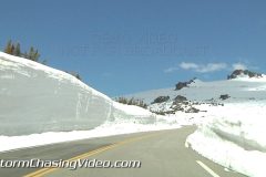
Colorado Rocky Mountain National Park Trail Ridge Road is finally open for the season. Even though the road is now open, the snow pack is extremely high along the sides of the trail.
Clips 1-2 South Navey Hill Rocky Mountain National Park
Clip 3 Trail Ridge road Beaver Meadow passing bicyclists heading up
Clip 4 Trail Ridge road wet from melting snow
Clip 5 Trail Ridge road snow on side of road as car passes by
Clip 6 Trail Ridge road snow on side of road as cars pass by
Clip 7 Trail Ridge road about 35 seconds of Deep snow on side of road in a forest of trees
Clip 8 Trail Ridge road deep snow on edge of road motorcyclists on side of road
Clip 9 Trail Ridge road passing cyclist
Clip 10 Trail Ridge road Rainbow Curve line of cars going up passing snow plow
Clip 11 Trail Ridge road Rainbow Curve passing walkers on side edge or road
Clip 12 Trail Ridge road passing snow plow high up mountain pass
Clip 13 Trail Ridge road extremely deep snow both sides of road alpine tundra level about 60 seconds
Clip 14 Trail Ridge road extremely deep snow following car along 15 foot wall of snow
Clip 15 Trail Ridge road Forest Canyon overlook 105 seconds of panoramic view from top
Clip 16 Trail Ridge road Forest Canyon overlook couple walking on snowy ridge
Clip 17 Trail Ridge road Forest Canyon overlook couple being photographed by friend
Clip 18 Trail Ridge road Forest Canyon overlook couple walking on snowy ridge
Clip 19 Trail Ridge road Forest Canyon overlook feet of people walking on snowy ridge
Clip 20 Trail Ridge road Forest Canyon overlook feet of people playing in snow
Clip 21 Trail Ridge road Forest Canyon overlook feet of people playing in snow
To license this footage, visit http://www.StormChasingVideo.com
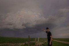
Footage of monster striated supercell thunderstorm producing damaging baseball-sized hail, severe high winds, large gustnadoes, and a haboob along Interstate 80 in western Nebraska in/near the towns of Chappell & Kimball, NE. Large baseball & tennis ball size hail shatters car windshield in Chappell, NE. Haboob & gustnadoes from severe winds make driving dangerous on I-80.
All footage from afternoon/evening near Chappell & Kimball, NE during daylight on May 19, 2014, run time 3:41 minutes, file size: 425 MB
Shot List:
1. wide shot of monster supercell with lightning strike over Interstate 80 near Chappell, NE
2. wide shot of monster supercell over I-80 near Chappell, NE
3. wide panning shot (from left to right) of striated monster supercell with lightning strike over traffic approaching Chappell, NE along I-80
4. wide shot of traffic on I-80 passing under monster striated supercell near Chappell, NE
5. wide shot of striated shelf cloud bearing down on Chappell, NE
6. pushed-in shot of wind-driven large hail, rain & debris racing past oncoming traffic in Chappell, NE
7. pushed-in shot of police truck driving through wind-driven large hail, rain, and debris in Chappell, NE
8. pushed-in shot of large hailstone held next to shattered windshield in Chappell, NE
9. pushed-in shot of large damaging hailstones (2+ inches in diameter) held next to measuring ruler in Chappell, NE
10.wide panning shot (left to right) from outside to inside car showing shattered windshield from massive hailstones in Chappell, NE
11. wide POV driving shot of large dust cloud with gustnado, wall cloud, and mesocyclone from large supercell near Chappell, NE
12. wide POV driving shot of large dust cloud with gustnado & wall cloud near Kimball, NE
13. pushed-in driving shot of large gustnado near Kimball, NE
14. pushed-in driving shot of large gustnado near Kimball, NE
15. wide shot of amazing supercell structure with large gustnadoes near Kimball, NE
16. POV driving shot of large dust cloud & gustnado & supercell on Interstate 80 near Chappell, NE
17. POV driving shot of large gustnado with construction sign knocked to ground by damaging winds near Chappell, NE
18. wide POV driving shot of large gustnado & construction barrel knocked over by high winds near Chappell, NE on I-80
19. wide POV driving shot of large gustnado over I-80 with traffic near Chappell, NE
20. timelapse POV driving shot of large gustnado & supercell over I-80 near Chappell, NE
21. timelapse POV driving shot into gustnado on I-80 near Chappell, NE
22. pushed-in POV driving shot of tumbleweeds, dust, & debris blowing over I-80 with traffic from severe winds & gustnado
23. pushed-in driving shot of large “haboob” dirt cloud behind trees approaching I-80 with supercell near Chappell, NE
24. pushed-in POV driving shot of traffic on I-80 with debris & massive “haboob” dirt cloud blowing over highway from severe winds with supercell near Chappell, NE
25. wide driving shot of supercell gust front approaching Chappell, NE
26. wide shot of windmill with supercell wall cloud in background
27. pushed-in shot of windmill spinning with supercell wall cloud in background
28. wide shot of cattle with supercell in background
29. pushed-in shot of cattle with supercell in background
30. pushed-in shot of “I-80” highway sign with supercell thunderstorm in background
To license this footage, visit http://www.StormChasingVideo.com
To help support our freelancers, buy them coffee. https://www.buymeacoffee.com/stormchasing
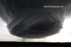
Intense footage of damaging, wind-driven baseball-sized hail pounding car & location from incredible low precipitation supercell (LP Supercell) with cone funnel cloud southwest of Newcastle, WY. Winshield is shattered by baseball-sized hail and footage of tumbleweeds, hail, & debris blown at high velocities past vehicle.
All footage shot during afternoon/evening during daylight of May 18, 2014 near/southwest of Newcastle, WY
Shot List:
1-3. various wide shots of incredible low precipitation supercell structure with mesocyclone and wall cloud southwest of Newcastle, WY
4. wide time lapse shot of incredible supercell structure southwest of Newcastle, WY
5. wide shot of cone funnel cloud & rotating wall cloud near Newcastle, WY
6. pushed-in shot of cone funnel cloud under rotating wall cloud with hail falling near Newcastle, WY
7. pushed-in shot of cone funnel cloud near Newcastle, WY
8. wide shot of rotating wall cloud, dirt kicked up by high winds, & baseball-sized hail falling & shattering on ground near Newcastle, WY
9. wide shot of intense baseball-sized hail battering location & shattering on ground with sounds of hail damaging car near Newcastle, WY
10.pushed-in POV shot of large hail smashing against & shaking windshield
11 & 12. wide (high looking down) shots of baseball-sized hail smashing against car breaking windshield & shattering on road, with high winds
13.wide (low) shot of baseball hail pounding car & shattering on roadway with high winds
14.pushed-in POV shot of large hail bouncing on road & grass with high winds blowing debris & tumbleweeds
15 & 16. wide shots of rotating wall cloud & high winds blowing large hail, debris, & tumble weeds past camera
17.pushed-in POV driving shot of hail-covered highway & large hail falling
18.pushed-in POV driving shot of large hail shattering & accumulating on highway
19.wide POV driving shot of rotating wall cloud in background with shattered windshield from baseball-sized hail in foreground
20.pushed-in shot of shattered windshield from baseball-sized hail in foreground with setting sun in background
21.pushed-in shot looking down on shattered windshield from baseball-sized hail
22.pushed in shot of shattered wind shield from baseball-sized hail
23.pushed-in shot of large dent with chipped paint from baseball-sized hailstones
24.pushed-in panning shot (from right to left) following running Pronghorn deer (called American Antelope) ahead of dangerous supercell thunderstorm near Newcastle, WY
25.pushed-in shot of “Newcastle” Wyoming city road sign
SID: StormRiders
http://www.stormchasingvideo.com/scv-merch-store/
Video package of tornadic supercell thunderstorms near the town of Grafton in SE Nebraska.
Video includes:
1) tornado with brief touchdown near Grafton Nebraska
2- 6) shots of wildly rotating mesocyclone and funnel clouds; sirens sounding in the town of Geneva.
A long-lived line of storms developed across Kansas early Sunday morning and trucked east into Missouri where it lead to numerous warnings and reports of wind damage.
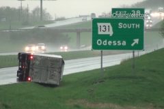
At 12:51pm, the National Weather Service issued a ‘TORNADO WARNING’ for a cell that had strong rotation on radar near Odessa along I-70. Damage was then reported in town, including an overturned semi at the Odessa exit and minor building/tree damage in town. A mobile home park on the east side of town had numerous homes damaged by the storm. Several trees were downed in town and there was also damage to a gas station. Initial reports as straight line winds, but radar indicated rotation over town at the time the damage was reported.
No injuries were reported.
Scene 1-2: Shots of overturned semi-truck with the Odessa exit sign next to it.
Scene 3-5: Various angles of overturned semi.
Scene 6: Panned shot of damaged gas station roof with metal peeled off.
Scene 7: Panned shot of debris on the ground up to the damage gas station roof cover.
Scene 8-10: Various shots of damaged gas station.
Scene 11-12: Shots of damaged roof on a mobile home in town.
Scene 13-14: Two angles of metal roofing bent around a sign post.
Scene 15: Panning shot from metal piece to a downed telephone/light pole.
Scene 16: Shot of downed power pole with line nearly fallen on a car.
Scene 17: Panning shot up downed pole.
Scene 18: Static shot of down pole.
Scene 19: Panned shot from broken wind on the ground to the damaged mobile home it came off.
Scene 20: Wide shot of mobile home with down tree in front yard.
Scene 21-22: Man dragging a tarp followed by shot of man stapling tarp to mobile home side damaged in the storm.
Scene 23: Shot of down tree in parking lot of bank.
Scene 24: Shot of bank sign with down tree.
Scene 25-30: Various shots of driving winds and rain on the interstate behind the damaging part of the storm.
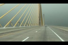
Brian Dombrowski is out chasing along the Gulf Coast of Florida just south of Tampa, FL to intercept the line of storms moving inland. First ever live stream to YouTube LIVE of crossing the Sunshine Skyway Bridge.
To view the GPS location, http://www.livenewsvideonetwork.com/live-tracking-briand/
Copyright 2013 StormChasingVideo.com & LiveNewsVideoNetwork.com
*** NO THIRD PARTY USE W/O LICENSE ***
SID=BrianD
TVID=TWC
SCV stringer Doug Kiesling is live on the winter storm hitting the Twin Cities in Minnesota tonight. Live winter storm chasing live video.
Live GPS tracking link:
http://www.livenewsvideonetwork.com/live-tracking-dougk/
Copyright 2014 StormChasingVideo.com & LiveNewsVideoNetwork.com
*** NO THIRD PARTY USE W/O LICENSE ***
SID=DougK
TWC
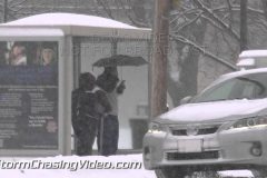
The Twin Cities metro area is surrounded by blizzard warnings but in the metro area, the winds were slightly calmer but the roads were still a mess.
Footage shot in Minneapolis, MN and Burnsville, MN were the roads were hazardous to drive on.
Clip 1 Skyline shot of Minneapolis, MN
Clip 2 Reverse POV shot in front of a MNDot Snow Plow on Interstate 35w in Burnsville, MN
Clip 3-7 Whiteout Conditions in Minneapolis on the east side of Lake Calhoun.
Clip 8 Sign in Minneapolis showing a snow emergency was declared.
Clip 9 Close up of a tire spinning in the snow in Burnsville on Nicollet Avenue.
Clip 10 Car spinning its wheels trying to get up Nicollet Ave in Burnsville.
Clip 11 Flags blowing with part of the Minneapolis skyline in the back ground.
Clip 12 Snow plow on Hennepin Ave in Minneapolis
Clip 13 A rear wheel van spinning its wheels trying to get up a hill on Nicollet Ave in Burnsville.
Clip 14 Wide shot of the van spinning its rear tire.
Clip 15 Car getting stuck on Nicollet Avenue in Burnsville. Shot from dash camera.
Clip 16 People helping to push a car out of the snow on Nicollet Ave. One of them is wearing shorts in the winter storm.
Clip 17 Car spinning its wheels.
Clip 18 Car getting unstuck but still spinning its wheels on Nicollet Ave.
Clip 19 Snow plow on Nicollet Ave in Burnsville.
Clip 20 Car crashed on the side of interstate 494 and 169 on 494.
Clip 21 Someone riding their bike in front of the truck in the winter storm in Minneapolis.
Clip 22-23 Minneapolis Fire Truck on the scene of a power line down.
Clip 24 Powerlines sagging in the heavy snow and ice.
Clip 25 – 29 Tree’s down on power lines and side walks in Minneapolis.
SID: Nick Elms
Major severe weather event threatens the Mississippi Valley following two months of brutal cold and winter storms. Tornadoes and supercell thunderstorms threaten areas from Louisiana to Illinois. Meteorologists and storm chasers capture a dangerous wall cloud from a tornado-warned supercell thunderstorm as it passes over Memphis, TN at rush hour.
All shots were taken during the daylight afternoon and early evening of February 20th, 2014
Scenes:
1-3. wide and pushed in shots of wall cloud from Tornado-warned supercell thunderstorm over Memphis, TN with heavy rush hour traffic
4-7. various shots of heavy rush hour traffic in Memphis, TN as tornado-warned supercell thunderstorm passes over city
8. pushed-in shot of colorful clouds from sunset over Memphis, TN following passage of tornado-warned supercell thunderstorm
9. pushed-in shot of “Tennessee” welcome sign near Memphis
10. pushed-in shot of Memphis, TN radar image with tornado-warned supercell thunderstorm over city and storm chaser’s position
B-Roll footage of the start of the powerful winter storm system as it makes its way into the northwestern suburbs of the Twin Cities metro area. Various shots of snow plows and snow falling scenes around Saint Cloud, MN along Interstate 94.
SID: Douglas Kiesling
To license this footage, visit http://www.StormChasingVideo.com
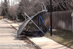
Strong winds impacted the Colorado Front Range across the Denver metro area overnight Monday and caused scattered damage to trees, fences, and other structures. Wind gusts up to 85mph were reported near Boulder with those hurricane force gusts impacting the Ken Caryl area in Littleton, Colorado on the southwest side of the Denver Metro Area where this package is shot. Denver International Airport measured a gust of 59mph overnight with many areas across town reaching up to 75mph.
More strong winds are expected overnight Tuesday as a HIGH WIND WARNING remains in effect for the Front Range and western suburbs of Denver through Tuesday morning.
Package shot in the Ken Caryl area of Littleton, Colorado.
Scenes 1-8: Various shots of two large pine trees that were downed overnight in the winds and destroyed a fence. Both trees came down along Chatfield Avenue in Littleton. Shots include angles of the downed trees, including a pan shot of parts of the fence that were blown into the median.
Scenes 9-10: Shots of a trampoline that was hurled over a fence in the Ken Caryl neighborhood.
Scenes 11-12: Shots of the Chatfield Avenue sign at Ken Caryl Road that was bent off the light post.
Scene 13-14: Shots of a power crew repairing the intersection area from the wind damage.
Scene 15-19: Various shots of damaged fences in the Ken Caryl area.
Scene 20: Shot of large branches in the median of Chatfield Avenue.
Scene 21-22: Shots of Ken Caryl Plaza sign bent off the platform at a nearby shopping center.
SID: Tony Laubach
A large winter weather system played havoc with the morning commute in central Iowa as up to 5-inches of snow fell across parts of the Des Moines area.
Shot 1, Rest Area on I-80 EB near Waukee, IA
Shot 2, Same location- i-80 Traffic
Shot 3,4,5 Traffic on Jordan Creek Parkway in West Des Moines
Shot 6, Drake University Campus- Des Moines
Shot 7- Hotel snow removal Holiday Inn Des Moines (6th Ave)
Shot 8- 31st St and I-235 traffic
Shot 9- Pedestrians in snow 7th St, Des Moines
Shot 10- 235 near 8th St, EB
SID=Brennan Jontz
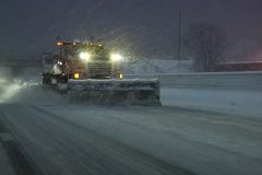
Video Footage Highlighting the Intense and quick hitting Winter storm impacting the Twin Cites Metropolitan Area right at the top peak of the Morning Rush Hour travel commute!
Video footage features include;
1.Extreme Close up Shot of 2 Minneapolis snow plows fighting to keep the city streets clean during a heavy snowfall burst.
2.Multiple POV Close ups of County and State snowplows working and plowing highways and major roadways in the intense snowfall and gridlock traffic.
3.Local snowfall removal operations footage shot featuring a large snowblower blowing snow as well as a very large snow plow clearing the streets full across.
4.POV shots of the snarled slow moving gridlock traffic on Interstate 35 in the Minneapolis area at the peak of the intense snowfall bursts.
5.People shoveling the heavy snow and struggling to keep up with the 2 inch per hours snowfall rates in St.Paul MN.
6. Shots of difficult travel conditions and heavy snow covered roadways along with the poor visibility in Minneapolis.
SID: Nick Elms
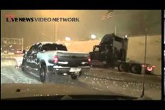
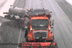
Video Footage highlighting the very heavy snowfall bursts that impacted the Twin Cites Metro area in the mid to late afternoon hours dropping 1-3 inches of snow in a short time and catching motorists and travelers off guard!
Video footage includes;
1. High speed large MNDOT snowplow oncoming and close at the cammera POV.
2. SUV spun out in the ditch median with a flatbed tow on the scene while very heavy snow falls.
3. Multiple POV shots of the crash scene as well as the slow traffic and ice and snow covered roadways while heavy snow falls in the shot.
4. Shots of single and multi vehicle crashes in the Minneapolis area with troopers and tow trucks on the scenes.
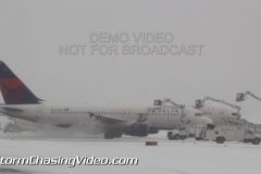
5. MSP Airport snow removal and major deicing operations while under a temporary break in the delay ground stop on the field. , Shots include multiple POV’s of deicing on the main runway, departure backups, blowing and drifting snow on the taxiways as well as major runway snow removal operations at close range near the main runway.
SID: Nick Elms
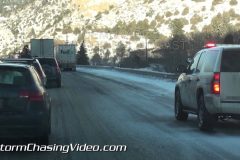
Icy winter conditions lead to slow driving along I-70 in the mountains west of Denver where travelers were left sitting on the interstate at times because of the conditions.
Scenes 1-2: POV shots of C-DOT electronic signs warning drivers of icy conditions.
Scene 3: Pulling up to the scene of a stopped Highway Patrol vehicle behind a semi stuck on the ice.
Scene 4: Cool shot of Highway Patrol in wind-driven snow along I-70 in Clear Creek County.
Scene 5: Driving by the highway patrol on the highway that is blocking the right lane.
Scene 6: Close-up of semi-truck wheels spinning on ice as camera passes on the left. The semi was unable to proceed due to the ice on the highway.
Scenes 7-8: Shots of stopped traffic on I-70 taken from the backup.
Scenes 9-10: POV drive shots of interstate conditions east of the Eisenhower Tunnel in Clear Creek County.
Scene 11: EB snowplow on I-70.
Scene 12: Shot of snowplow on local road just off I-70 in Clear Creek County.
Scene 13: Shot of ICY ROAD sign on local road just of I-70.
SID: Tony Laubach
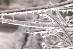
Historic ice storm cripples the Southeast prompting a “Civil Emergency” to be ordered for most of South Carolina. Barnwell, SC takes brunt of ice storm receiving over `1 inch of accumulated glaze ice from freezing rain taking down utility lines and trees. Roads are treacherous if not impassible and there are power outages surrounding Barnwell. Utility crews work hard to fix downed lines and remove trees to get power restored to the area.
All scenes shot in and around Barnwell, SC during the morning of February 13, 2014.
Scenes:
1-5: shots of utility Crews working to fix power lines in Barnwell, SC
6: large tree branch hanging on power lines
7 & 8: pushed in shot of ice covered power lines and pole
9. pushed in shot of utility truck navigating around fallen trees and low hanging ice covered power lines
10. emergency crews clearing trees and debris from roads
11 & 12: shots of car trapped in ditch
13 & 14: shots of large uprooted tree smashing a residential fence in Barnwell, SC
15: shots of vehicles navigating treacherous roads with fallen and falling trees
16. pushed-in shot of ice covered power lines and trees along treacherous road
17. shot of “Barnwell, SC” sign surrounded by fallen tree branches
18. point of view driving shot navigating around fallen trees on road
19. point of view driving shot of ice-covered fallen trees on side of road
20. quick point of view driving shot of debris falling from a tree
21. shot of Barnwell water tower, ice covered trees & power lines, and traffic
22. pushed in shot of many ice covered trees
23. pushed in shot of frozen American flag
24. shot of ice covered branches
25. pushed in shot of ice-covered branches
26. pushed in shot of “Hurricane Evacuation Route” sign covered in ice, hurricanes are typically disasters in this part of the country, not ice storms
27. wide shot of many bent and fallen trees covered in thick ice
To license this footage, visit http://www.StormChasingVideo.com
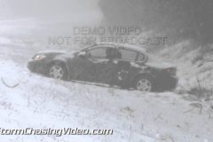
A second historic powerful winter storm paralyzes the Deep South. Incredibly heavy snow fall causes I-95 to become very hazardous near Rocky Mount, NC. Many vehicles are caught stranded in ditches along I-95 after losing control on the ice and snow covered road. All scenes were captured along I-95 near Rocky Mount North Carolina during the afternoon and early evening of February 12, 2012. This winter storm has been named Pax.
Scenes:
1. pushed-in shot of Woman walking away from stranded with car in ditch with heavy snow falling near Rocky Mount NC
2. Point of view shot of SUV quickly going off road on snow and ice covered roads near Rocky Mount NC
3. point of view shot of vehicles driving in heavy snow storm near Rocky Mount NC
4. pushed-in shot of vehicles driving on ice and snow covered roads with heavy snow falling in Rocky Mount NC
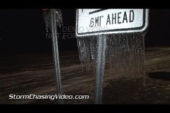
5. point of view driving shot of near white-out conditions with heavy snow and highway sign on I-95 near Rocky Mount, NC
6. pushed-in shot from above of traffic driving in nearly white-out conditions on I-95 near Rocky Mount NC
7. pushed-in shot of traffic driving in very heavy snow on I-95 near Rocky Mount NC
8. wide shot of traffic driving in very heavy snow on I-95 near Rocky Mount NC
9. wide shot of police cruiser next to car in ditch with driver inside with heavy snow falling on I-95 near Rocky Mount NC
10. pushed-in shot of police cruiser on I-95 with heavy snow falling near Rocky Mount NC responding to a stranded vehicle
11. pushed-in shot of car and driver stranded in ditch after sliding off I-95 with heavy snow falling near Rocky Mount NC
12. wide shot with police cruiser responding to driver stranded with car in ditch off I-95 near Rocky Mount NC
13. wide shot of truck trapped in ditch with hazard lights on in with heavy snow falling next to I-95 near Rocky Mount NC
14. pushed-in shot of truck with hazard lights on trapped in ditch off I-95 near Rocky Mount NC with heavy snow falling
15. wide shot of police officer exiting and then entering his cruiser at scene of multi-car accident on I-95 with heavy snow falling and heavy traffic near Rocky Mount
16. pushed-in shot of 2 of 3 cars in a large accident on I-95 with heavy snow falling near Rock Mount
17. wide shot of heavy traffic lined-up on I-95 due to multi-car accident with heavy snow falling near Rocky Mount
18. pushed-in shot of heavy traffic lined-up on I-95 due to multi-car accident with heavy snow falling near Rocky Mount
19. wide shot of “I-95” sign covered in ice from powerful winter storm
20. pushed-in shot of “I-95” sign covered in ice from powerful winter storm
21-24. shots of very heavy large snow flakes falling on I-95 near Rocky Mount NC
To license this footage, visit http://www.StormChasingVideo.com
Powerful historic winter storm covers Manning, South Carolina in glaze ice from heavy freezing rain. A “Civil Emergency” is issued for most of South Carolina as it will be paralyzed by this storm. Some areas around Manning have .75 inches (3/4 inches) of ice on trees, powerlines, grass, and signs. The heavy ice is causing power outages and bringing down large trees blocking portions of heavily trafficked Interstate 95 making travel very treacherous and sometimes impossible. Police and fire crews race to cut, move, or mark the fallen trees. This area is the northern territory for the American Aligator, yet it’s being hammered by a fierce winter storm.
All the of the scenes were shot in or near Manning, SC in the late evening and night of February 12, 2014.
Scenes:
1. wide shot of emergency vehicles with lights reflecting off fallen ice-covered trees on I-95 near Manning SC; large loads of glaze ice from freezing rain was bringing down large trees over the Interstate Highway
2. wide shot of policemen and firemen attempting to move a large tree blocking a southbound lane on I-95, emergency vehicles with lights reflecting off fallen ice-covered trees on I-95 near Manning SC
3. wide shot of policemen and firemen with flash lights attempting to move a large tree blocking a southbound lane on I-95, emergency vehicles with lights reflecting off fallen ice-covered trees on I-95 near Manning SC
4. wide shot of policemen pulling a tow cable around a fallen tree in a failed attempt to move a large tree blocking I-95 near Manning SC
5. wide shot of fallen tree on I-95 with ice covered limbs lit my emergency vehicles as they try to move the large obstruction
6. wide shot of car and ice covered limbs of a slowly falling tree on I-95 near Manning SC
7-10. shots of police and firemen cutting a large fallen tree with a chain saw in an attempt to move the obstruction from I-95 near Manning SC
11. shot ice-covered trees threatening I-95 with limbs illuminated by emergency vehicle lights near Manning, SC
12. pushed-in shot of ice-covered “Paxville and Manning” highway exit sign off I-95 in Manning SC
13-15. pushed-in, pulled-out, and panning shot of road sign covered in .75 (3/4) inch glaze ice from freezing rain near Manning SC
16. pushed-in shot of street lamp with icecicles with heavy freezing rain falling in Manning SC
17. wide shot of water, ice, and sleet covered roads in Manning SC
18. pushed-in shot of ice-covered road with car and pedestrian crossing near Manning SC
19 & 20. pushed-in and pulled-out shots of ice-covered palm tree near Manning SC
21-23. shots of tropical plant covered in ice near Manning SC
24-26. shots of massive ice-covered American Flag flapping with force in the high winds near Manning SC
To license this footage, visit http://www.StormChasingVideo.com