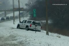
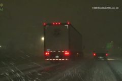
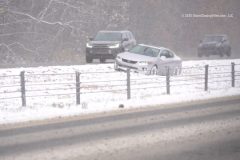
Another winter storm hit the Twin Cities Tuesday afternoon into the evening hours, bringing several inches of snow to the region. By the evening commute, roads were snow-covered, and travel across the Twin Cities was slow due to the slick roads and reduced visibility. The following video was captured in Minneapolis and Maple Grove, Minnesota, showing harsh travel conditions, a few vehicles that lost control and got stuck in ditches, and moderate to heavy snowfall.
Shot Description
00:00 A couple of clips of a BMW stuck in the snow in the ditch and the BMW getting towed out of the snow in the ditch near Maple Grove, Minnesota.
00:20 A video of traffic driving past the camera as snow falls.
00:36 A couple of clips showing a pickup truck that lost control, went off the road, and got stuck in the ditch along I-494 near Minneapolis.
01:01 Video of a lighted MnDOT sign warning drivers of a crash ahead on Highway 169.
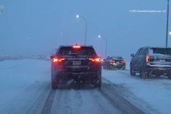
01:14 Video at night showing heavy traffic in both directions on the highway with snow-covered roads and snow actively falling in the northern Twin Cities suburbs.
01:47 Video from a gas station showing a lady getting into her snow-covered vehicle with the falling snow being illuminated by the vehicle's headlights.
01:56 Video of a guy kicking the frozen snow off of his front tire at the gas station as snow continues to fall.
02:23 Video of moderate to heavy snow falling and being illuminated by the parking lot lights.
02:28 Video of a lady checking her window wipers and removing ice from them as moderate to heavy snow is falling.
02:50 Video of a plow truck plowing the parking lot in front of some stores as snow is actively falling.
03:01 Video of the plow truck going back again, with the camera in the parking lot, with moderate to heavy snow still falling, and someone getting into their vehicle in the background.
03:22 Close shot video showing the person in the previous clip brushing the snow off their vehicle with snow falling and blowing around.
03:31 The plow truck goes by in the background of the vehicle where a person is clearing snow off their vehicle.
03:51 Another video of someone brushing off snow from their vehicle shows additional moderate-to-heavy snow falling in a parking lot.
04:02 Video of the plow truck going by again and clearing the parking lot as more snow is falling.
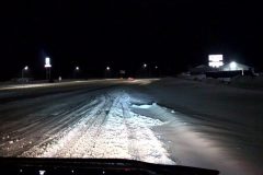
04:09 Various videos of completely snow-covered and compacted highway roads, with moderate snow actively falling. The reduced visibility from the snow can be seen, along with slow travel speeds.
04:38 Video of a tow truck sitting in the left lane with its lights on as moderate to heavy snow is falling, and two state plow trucks can be seen in the background with heavy traffic.
04:46 More video of slow traffic on snow-covered highway roads, and a Minnesota State Patrol car on the side of the road with a vehicle that appears to have gotten stuck or crashed.
SID: Hunter Anderson
#winterstorm
#snowstorm
#weather
#minnesota
To help support our freelancers, buy them coffee. https://www.buymeacoffee.com/stormchasing/
To License This Footage For Broadcast, Contact Video @ StormChasingVideo.com
Our Team Merch Store – https://stormchasingvideo.creator-spring.com
Dangerous winter storm hits Minneapolis metro area at rush hour resulting in very slow traffic, snow covered slippery roads, car accidents and deep snow accumulating on side streets.
Shot Description
00:00 – 00:13 – Heavy snow falling and 2 vehicles in the shoulder after fender bender accident on Hwy 169 near St. Louis Park suburb
00:13 – 00:25 – Car in the ditch covered in snow and truck in the shoulder on Hwy 169 near Golden Valley
00:25 – 00:37 – Car in the shoulder with tire off on Hwy 160 and 610
00:37 – 00:54 – Snow plows slow down heavy traffic on snow covered roads on Hwy 169 and I-394, West of Minneapolis
00:54 – 01:10 – Stopped traffic on snowy roads under Minneapolis road sign at on Hwy 169 and I-394 West of Minneapolis
01:10 – 01:32 – Road conditions worsening and getting more snow packed as it gets darker and traffic slows more West of Minneapolis
01:32 – 01:40 – Deep snow on West River Road with small snow removal vehicle at end of driveway in Champlin
01:40 – 02:01 – Local residents shovel their driveways as heavy snow falls in Champlin
02:01 – 02:12 – Deep snow and large Snowman Christmas decoration in front yard in Champlin
02:12 – 02:29 – Heavy snow with large snowflakes fall on pine trees in Champlin
02:29 – 03:02 – Two small dogs run and play in the deep snow in Champlin, MN
SID: Melanie Metz
#winterstorm #snowstorm #mnwx #minneapolis
To help support our freelancers, buy them coffee. https://www.buymeacoffee.com/stormchasing/
To License This Footage For Broadcast, Contact Video @ StormChasingVideo.com
Our Team Merch Store – https://stormchasingvideo.creator-spring.com
We are back on the road with the live steam.
Our location is http://glympse.com/BHkV-8gHU
To help support our freelancers, buy them coffee. https://www.buymeacoffee.com/stormchasing/
To License This Footage For Broadcast, Contact Video @ StormChasingVideo.com
Our Team Merch Store – https://stormchasingvideo.creator-spring.com
Early snow in Richmond, VA.
Shot Description
Snow with a person walking a dog
Woman walking on snowy city sidewalk (close and wide angle, no sound)
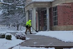
Workman shoveling snow at a medical clinic
Workman sanding sidewalk
Walking a dog near Fox Elementary School
SID: William Hark
#snow #VAWX #winter #weatherevents
To help support our freelancers, buy them coffee. https://www.buymeacoffee.com/stormchasing/
To License This Footage For Broadcast, Contact Video @ StormChasingVideo.com
Our Team Merch Store – https://stormchasingvideo.creator-spring.com
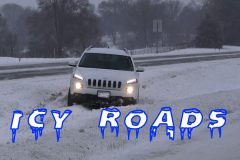
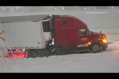
An early morning snowstorm created icy roads with slick and hazardous driving conditions along the Interstate 94 corridor just northwest of the Twin Cities Metro in Saint Cloud, MN. Numerous wrecks and spin-outs where reported during the morning commute.
Shot Description
Clip 1 – Jeep stuck in the center ditch.
Clip 2 – MN State Patrol on the scene of a crash.
Clip 3 – 8 Several clips of multiple vehicles that spun out and are being recovered on the northwest side of the Saint Cloud Metro area on I-94.
Clip 9-17 POV and side camera shot of numerous vehicles that crashed and are being recovered on I-94.
Clip 18 POV driving shot in snow on I-94
Clip 19 – 23 Several clips of snow plows.
SID: Doug Kiesling
#icyroads #winter #mnwx #snow
To help support our freelancers, buy them coffee. https://www.buymeacoffee.com/stormchasing/
To License This Footage For Broadcast, Contact Video @ StormChasingVideo.com
Our Team Merch Store – https://stormchasingvideo.creator-spring.com
Kansas City Metro between Raymore, MO (Cass County), Grandview, MO (Jackson County), and the Country Club Plaza, KCMO (Jackson County) struggled with the first snow of the year. Everything from semi trucks stuck on the side of the road to car wrecks with emergency vehicles to the Street Car needing help getting going.
Shot Description
Shots 1-5. Various angles of two cars in Raymore, MO, Cass County, surrounded by emergency vehicles, while a person is being put on a gurney to be taken to the hospital
Shot 6. Driving shot of a road sign identifying a stalled vehicle and road conditions on the northbound Interstate 49.
Shot 7-8. Driving shot on the northbound 71 highway in Kansas City, MO, Jackson County, with a semi spinning its tires, a truck losing traction for a moment, and a car that looks to have slid into the side of a double trailer semi.
Shot 9-12. Railcar workers pulling one of KCRide Railcars down the track after it looks like it stalled or became stuck in the South County Club Plaza area of KCMO, Jackson County
Shot 13. Road being plowed in the Waldo area of KCMO, Jackson County
Shot 14-15. Slow drive by shot of 2 cars off to the side with one car on a tow truck that looks to have been rear ended, with a person talking to a police officer on southbound Interstate 49 near Grandview, MO, Jackson County
#kcmo
#mowx
#snowstorm
#winter
#weather
To help support our freelancers, buy them coffee. https://www.buymeacoffee.com/stormchasing/
To License This Footage For Broadcast, Contact Video @ StormChasingVideo.com
Our Team Merch Store – https://stormchasingvideo.creator-spring.com
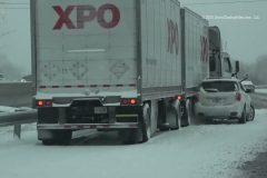
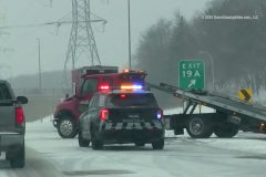
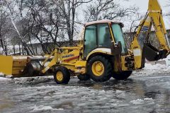
The Twin Cities area saw its second winter storm in a week, with around 2.5-5 inches of snow being reported across the Metro as of 7:30 PM. The steady snowfall and cold conditions resulted in compacted snow on the roadways and slick conditions. The following video was captured across the northern Twin Cities metro, showing slick, snowy conditions.
Shot Description
0:00 Video of an MnDOT sign warning drivers of an upcoming car crash outside of New Hope, Minnesota.
00:06 Video of a pickup truck that crashed into the median on the highway due to slick conditions.
00:13 Another video of the same truck that crashed, showing the Minnesota State Patrol and a tow truck on scene.
00:22 Two videos showing a big traffic backup with an MnDOT plow blocking the right lane ahead of an upcoming crash. A road sign for the I-394 exit for Minneapolis is visible in the background.
00:45 Video showing several emergency responders on the scene of a multi-vehicle crash involving trucks pulling trailers, including MnDOT, Minnesota State Patrol, Minnetonka Police, and tow truck drivers working to clear the scene.
01:10 Video driving down the highway with snow blowing and drifting.
01:16 Video of a guy using a leaf blower to clear the light and fluffy snow from his driveway.
01:31 Video of a lady in a Minnesota Gophers sweatshirt loading groceries from Target into the back of her vehicle as moderate snow is actively falling.
01:51 Various clips showing front loaders plowing a strip mall parking lot in Minnetonka, Minnesota. The video shows several inches of snow in the parking lot.
02:12 Video driving down the highway showing snow still falling and blowing around on the roadway.
SID: Hunter Anderson
#mnwx
#winterstorm
#snowstorm
#weather
#spinout
To help support our freelancers, buy them coffee. https://www.buymeacoffee.com/stormchasing/
To License This Footage For Broadcast, Contact Video @ StormChasingVideo.com
Our Team Merch Store – https://stormchasingvideo.creator-spring.com
Winter weather arrived in central Missouri on Saturday, with 6-10 inches of snow reported across parts of the region. As temperatures warmed into the afternoon, a mix of rain/snow began to fall. The following video was captured from the city of Mexico, Missouri, and the surrounding areas.
00:00 Wide and medium shots of people outside an auction being held near the city of Mexico during the snowstorm. People are seen bundled up as snow continues to fall.
00:28 A couple of shots of people walking into the barn where the auction is being held, bundled up with snow falling.
00:39 Two shots of several inches of snow on the ground as more snow is actively falling, and traffic is driving by.
01:00 A couple of clips of a backhoe tractor plowing the parking lot for a local grocery store as a mix of rain and snow is actively falling.
01:33 Close-up of the plow on the backhoe pushing the slush and water past the camera.
01:41 Wide shot of the backhoe plowing the slush, water, and snow into a pile at the end of the parking lot.
01:51 Wide shot of the grocery store showing piles of snow in the parking lot and slush in the foreground.
01:58 Video driving past someone trying to shovel several inches of snow from their front sidewalk in the middle of town.
02:20 Side view driving through town showing several inches of snow on the ground and sloppy roads.
02:15 Various clips driving out of town showing several inches of snow on the ground as a rain-snow mix continues to fall.
02:39 Video driving out of town with a plow truck visible in the distance, clearing the roadway.
02:53 Video of a vehicle driving down a hill as the pickup truck in front turns into a snow filled driveway.
03:04 Video of a back-country road covered in several inches of snow as they drive down the road.
03:13 A medium and close shot of a ruler showing almost 6" of snow having fallen in central Missouri.
SID: Sara Bruce
#MOWX
#winterstorm
#Snowstorm
To help support our freelancers, buy them coffee. https://www.buymeacoffee.com/stormchasing/
To License This Footage For Broadcast, Contact Video @ StormChasingVideo.com
Our Team Merch Store – https://stormchasingvideo.creator-spring.com
The Twin Cities, Minnesota, saw their first major snowstorm of the season Tuesday evening into Wednesday morning. Heavy snowfall and strong wind gusts resulted in slick roadways, reduced visibility from blowing snow, and hazardous conditions across the region. Winter storm Warnings remain in place until 9 AM Wednesday across the Twin Cities metro. Max wind gusts around 30-46 mph have been measured within the Twin Cities metro. The following video was captured in the cities of Maple Grove, Rogers, Eagan, and Burnsville, Minnesota, in the counties of Hennepin and Dakota, showing the hazardous conditions this system has caused.
00:00 Various clips of a plow gang following on the highway. Clips include slow traffic behind plows and an MnDOT sign that says Winter Storm Warning in Effect
00:11 Driving down the highway, a semi truck passes, and snow begins to fall at a heavier intensity, reducing visibility.
00:21 Video of a stop sign coated in ice and snow.
00:27 Video of flags blowing in the strong wind gusts with snow falling.
00:40 Various clips, wide and medium shots, of a large American flag blowing in the strong wind gusts in front of a car dealership with snow falling.
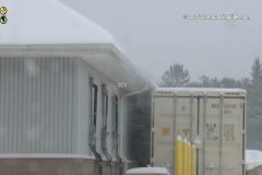
00:55 Video showing snow blowing off the roof of a building in the strong winds.
01:05 Video of a vehicle driving by as moderate snow falls to show reduced visibility.
01:08 Video of snow falling but also being blown around in the strong winds at a gas station.
01:14 Video showing the snow falling and being blown sideways in front of a highway sign for St Cloud and Minneapolis-St. Paul.
01:28 Video driving down the snow-covered highway with an MnDOT sign saying winter storm warning in effect as snow is falling.
01:34 Video driving down the snow-covered highway showing the reduced visibility and snow blowing sideways with a truck and semi truck in front of the camera, and various additional clips showing the bad driving conditions from the winter storm.
02:00 Video driving by a vehicle that went into the ditch along the highway with Minnesota State Patrol and a tow truck working to get the vehicle out.
02:10 Video showing a car that lost control on the slick and snow covered roadways and crashed into the guard rail.
02:21 Video driving under another MnDOT sign saying winter storm warning in effect with heavy snow and snow covered roads visible.
02:29 Video of a car in the ditch after loosing control on the dangerous roadways.
02:48 Video showing the heavy snowfall and gusty condtions resulting in the reduced visibility.
03:03 Wide and medium shots of an injury accident involving a vehicle versus a person on an electric scooter.
03:38 Wide and medium shots of Burnsville and Eagan Fire Departments investigating a possible fire after a tree branch took down a power line, which fell on top of a home.
To help support our freelancers, buy them coffee. https://www.buymeacoffee.com/stormchasing/
To License This Footage For Broadcast, Contact Video @ StormChasingVideo.com
Our Team Merch Store – https://stormchasingvideo.creator-spring.com
The first powerful winter storm brought blizzard conditions to parts of the Upper Midwest, right before the busiest travel day of the year, as millions are hitting the road for Thanksgiving.
The first part of the video, from 00:00 to 01:01, was shot in Alexandria, MN, which is in Douglas County.
The rest of the footage was shot in Stearns County, MN.
The video focuses on the travel nightmare as early afternoon rain froze, and the weather turned to heavy snow on Interstate 94, creating very treacherous, icy roads.
Footage shows lots of crashes and vehicles in the ditch, snow plows, and very poor visibility while driving in near whiteout conditions at times.
Shot Description
00:00 – 01;01 Walmart Semi Truck stuck on the side of the exit ramp on Interstate 94 and the big rig tow truck can't get it to move due to the icy conditions.
01:01 – 01:10 Flags blowing in the high winds to show the conditions in Saint Cloud, MN.
01:11 -02:33 Various shots of snow plows on Interstate 94 northwest of Saint Cloud, MN. First shot opens with a car in the ditch with a first responder on the side of the road as a snowplow drives by. Footage continues with various snowplow clips.
02:35 – 02:48 Traffic Sign warning of Interstate 94 and Interstate 29 closed at Fargo.
02:48 – 04:32 Eight different clips of vehicles that crashed into the ditch along Interstate 94.
04:32 – 05:57 Five different clips showing the very low visibility conditions on the interstate with the heavy blowing snow.
#mnwx
#blizzard
#winterstorm
#crash
To help support our freelancers, buy them coffee. https://www.buymeacoffee.com/stormchasing/
To License This Footage For Broadcast, Contact Video @ StormChasingVideo.com
Our Team Merch Store – https://stormchasingvideo.creator-spring.com
Isolated strong to severe storms occurred across central Missouri on Monday, November 17, 2025, when the Storm Prediction Center issued a Marginal Threat (1 out of 5) for severe storms. The main threat from this elevated convection was hail. Around 4:30 PM, these storms moved into Mexico City, Missouri, where heavy rain and hail fell, resulting in hailstone drifts of 6.0-7.5 inches deep along the sides of the road and in parking lots. The following video shows just some of that hail accumulation in the city.
Shot Description
00:00 Wide and medium shots of hailstone drifts following strong to severe storms working through Mexico City, MO, that were at times 6.0-7.5 inches deep. A couple of shots have a measuring stick showing the depth of the hailstone piles.
00:31 A couple of close-up and medium shots showing a pile of hail around 6-6.5 inches deep.
00:46 A medium shot of the pile of small hail.
00:50 A wide shot showing the hailstone drift/piles along the side of the road with a ruler in it.
00:54 A couple more wider shots with an SUV in the hailstone piles.
01:03 A medium shot showing another large hail drift or pile.
01:08 A closer shot of a ruler in the hail drift/pile showing the pile to be about 7-7.5 inches deep.
01:12 A couple of videos show cars parked in a parking lot, with small amounts of hail piled along the curb, and a dog barking in one of the cars.
01:22 Close-up video of a hand holding a clump of pea-sized hail.
01:26 A couple of wide and medium shots of the parking lot for an Aldi in Mexico City, MO, with a person walking into the store.
01:36 A few wide shots of the storms rolling into Mexico City, Missouri, on Monday afternoon. You can see the gray/white hail shafts on the leading edge of the storms.
01:46 A couple of medium shots of the hail working closer to the camera. The white, hazy background is the hail working closer. You can also hear the hail following in the background and hitting the camera.
01:57 A couple of wide shots of the storms being lit up at sunset. Some cloud-to-cloud lightning can be seen at times.
SID: Sara Bruce
#hail
#hailstorm
#MOWX
To help support our freelancers, buy them coffee. https://www.buymeacoffee.com/stormchasing/
To License This Footage For Broadcast, Contact Video @ StormChasingVideo.com
Our Team Merch Store – https://stormchasingvideo.creator-spring.com
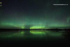
For the second night in a row, vivid Auroras or Northern Lights fill the sky over Stearns County, MN. Footage of the Aurora Borealis over a lake with the reflection off the lake and over fields north of town.
Shot Description
Clips 1-4: Auroras over a lake and reflecting off the water.
Clips 5-6 Auroras over an open field.
SID: Doug Kiesling
#auroraborealis
#northernlights
#spaceweather
#mnwx
To help support our freelancers, buy them coffee. https://www.buymeacoffee.com/stormchasing/
To License This Footage For Broadcast, Contact Video @ StormChasingVideo.com
Our Team Merch Store – https://stormchasingvideo.creator-spring.com
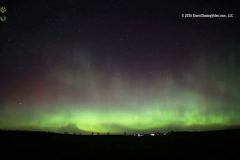
Night two of the auroras brought a weaker geomagnetic storm than last night, with tonight’s reaching G3 strength, which is still a strong storm. Still, it managed to put on a stunning aurora display.
Shot Description
Clips 1-2 The Auroras dancing in the sky.
SID: Dirk Miller
#auroraborealis
#northernlights
#wiwx
#spaceweather
To help support our freelancers, buy them coffee. https://www.buymeacoffee.com/stormchasing/
To License This Footage For Broadcast, Contact Video @ StormChasingVideo.com
Our Team Merch Store – https://stormchasingvideo.creator-spring.com
Time-lapse footage of one of the most powerful solar storms to hit the earth in a while sparked an amazing Aurora Borealis or Northern Lights over Saint John’s University in Collegeville, MN (Near Saint Cloud, MN). The Auroras were so bright that they could be seen in front of the Saint John’s Abbey with all the flood lights on the front face of the building.
Shot Description
Clip 1-3 Footage from the courtyard in front of the Saint John’s Abbey at Saint John’s University.
Clip 4 Just outside of the college on a dark dirt road, the Auroras filled the sky.
Clip 5 Looking straight up with a very wide-angle lens shows the massive crown of the Aurora pulsating in all directions.
Clip 6-7 The Aurora began to fade as the moon rose, washing out the sky before midnight.
SID: Doug Kiesling
To help support our freelancers, buy them coffee. https://www.buymeacoffee.com/stormchasing/
To License This Footage For Broadcast, Contact Video @ StormChasingVideo.com
Our Team Merch Store – https://stormchasingvideo.creator-spring.com
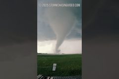
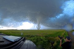
A violent tornado forms right before my eyes near Henry, SD — transforming from a swirling funnel into a full-blown monster as it tears across the field and destroys a farm in its path. Captured in real-time, this time-lapse shows nature’s raw power like never before.
#StormChasing #ExtremeWeather #NaturePower #TimeLapse #WeatherVideo #StormHunter #Twister #TornadoVideo #SDWX
Multiple accidents are causing severe traffic jams due to heavy lake-effect snow on highways in and near Crown Point, Indiana.
All footage shot on November 10, 2025, in/near Crown Point, Indiana, by Meteorologist and Storm Chaser Simon Brewer.
Shot Description
00:00 Various accidents on Interstate 65 from heavy lake effect snow.
01:15 Large traffic jam from accidents on I-65.
02:03 Snowplows are clearing snow from I-65
02:23 Traffic in deep snow on the highway
SID: Simon Brewer
To help support our freelancers, buy them coffee. https://www.buymeacoffee.com/stormchasing/
To License This Footage For Broadcast, Contact Video @ StormChasingVideo.com
Our Team Merch Store – https://stormchasingvideo.creator-spring.com
The first major lake-effect snow event of the season causes multiple accidents in and around La Porte, Indiana. A heavy lake effect snow band feeds off Lake Michigan, dumping deep snow over Northern Indiana.
All footage shot during evening darkness in/near La Porte, Indiana, by a Meteorologist and
Storm Chaser Simon Brewer.
Shot Description
00:00 People walking to the store and getting last-minute groceries with heavy snow falling
00:23 Accident with police assistance.
00:42 Tractor-trailer slid off the highway ramp into a ditch with heavy snow falling
01:23 Multiple accidents with snow falling and police assistance
01:40 Snowplow clearing highway
01:59 Police helping driver on I-94
02:15 Front loader clearing snow from the parking lot
02:47 Very heavy snow with low visibility on Interstate 94
03:36 Heavy snow in the neighborhood in La Porte, Indiana
SID: Simon Brewer
#inwx
#lakeeffectsnow
#lakeeffectstorm
#winter
#weather_news
To help support our freelancers, buy them coffee. https://www.buymeacoffee.com/stormchasing/
To License This Footage For Broadcast, Contact Video @ StormChasingVideo.com
Our Team Merch Store – https://stormchasingvideo.creator-spring.com
Lake-effect snow from Lake Superior created a slow and challenging Sunday for many residents in parts of Ashland and Iron Counties, Wisconsin. Those areas picked up 4 to 8 inches of snow. Hurley was right around 8 inches. This video package was shot in Iron County and in Hurley.
Shot Description
Clip1. Driving into the Lake Effect snow.
Clip 2. HWY 77 is starting to get snow-covered.
Clip3. A back road is getting snow-covered with snow falling.
Clips 4-6. Heavy snow is falling.
Clips 7-8. Snow covered HWY 77 with traffic.
Clip 9. Snow is sticking to the powerlines in Hurley, Wisconsin.
Clips 10-11. Snow blowing off a roof.
Clips 12-13. Vehicles are driving through the shot on Highway 77 in Hurley.
Clip 14. Snow covered the trees, bushes, and weeds.
SID: Dirk Miller
#winter
#snow
#WIwx
#polarvortex
To help support our freelancers, buy them coffee. https://www.buymeacoffee.com/stormchasing/
To License This Footage For Broadcast, Contact Video @ StormChasingVideo.com
Our Team Merch Store – https://stormchasingvideo.creator-spring.com
Want to come along on a virtual storm chase? We captured some insane footage over the summer.
We mounted an 8K 360° camera on the roof of our storm-chasing truck and captured the tornado that hit a farm in Henry, South Dakota, on July 27th, 2025.
The footage shows the tornado right after it formed, and then moved to obliterate a farm, and then moved off to the south.
#360video
#vrtornado
#360tornado
#VRStormChasing
#VRTornado
#Tornado
To help support our freelancers, buy them coffee. https://www.buymeacoffee.com/stormchasing/
To License This Footage For Broadcast, Contact Video @ StormChasingVideo.com
Our Team Merch Store – https://stormchasingvideo.creator-spring.com
First snow of the fall-winter 2025 season in north Iowa. Accumulations of 1-3 inches already on the ground.
Shot Description
0:00 tight shot of red car, snow falling
0:10 neighborhood and tree shot, snow falling
0:17 tight shot of a stop sign
0:23 driving shot, low visibility, light traffic
0:39 O’Reilly Auto Parts sign shot snow falling
0:48 highway intersection, low visibility, light traffic
0:59 Parked cars, snow falling
1:05 Snowy field, low visibility
1:15 neighborhood, vehicles, and tree shot, snow falling
1:21 Snow falling, wooded area
1:27 neighborhood, vehicles, and a tree shot of snow falling
SID: TJ Kleckner
#winter
#snow
#iawx
#polarvortex
To help support our freelancers, buy them coffee. https://www.buymeacoffee.com/stormchasing/
To License This Footage For Broadcast, Contact Video @ StormChasingVideo.com
Our Team Merch Store – https://stormchasingvideo.creator-spring.com
A fire consumed a home at 10th Avenue South and University Drive in the City of Saint Cloud, MN.
Reports from the scene indicate that all occupants made it out safely, but the home appears to be a total loss.
Multiple fire crews from surrounding cities provided mutual aid for this incident.
© 2025 Doug Kiesling – All Rights Reserved.
To help support our freelancers, buy them coffee. https://www.buymeacoffee.com/stormchasing/
To License This Footage For Broadcast, Contact Video @ StormChasingVideo.com
Our Team Merch Store – https://stormchasingvideo.creator-spring.com
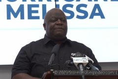
Raw press conference from The Bahamas emergency officials from the Disaster Risk Management Authority about the evacuation of the central and lower islands of The Bahamas and updated information about Hurricane Melissa hitting The Bahamas.
Shot Description
00:01 Press Conference Starting.
Geoffrey Greene, Director of the Department of Meteorology
Leon Lundy – Member of the Senate of the Bahamas And Manager Of Disaster Risk Management.
Aarone Sargent – Managing Director at Disaster Management Authority
Not shown but named
H, Alex Store, executive chairman of the Disaster Management Authority
SID: Bahamas Video
To help support our freelancers, buy them coffee. https://www.buymeacoffee.com/stormchasing/
To License This Footage For Broadcast, Contact Video @ StormChasingVideo.com
Our Team Merch Store – https://stormchasingvideo.creator-spring.com
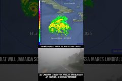
As Category Five #hurricane #melissa is about to hit #Jamaica, take a look at what it was like in the #eyewall of Hurricane Michael in Mexico Beach, FL in October of 2018
#Cat5 #landfall
To help support our freelancers, buy them coffee. https://www.buymeacoffee.com/stormchasing/
To License This Footage For Broadcast, Contact Video @ StormChasingVideo.com
Our Team Merch Store – https://stormchasingvideo.creator-spring.com
On June 28, 2025, my daughter Laura and I went out on her first real storm chase to intercept the slight risk tornado setup in Eastern South Dakota.
This was Laura’s first real chase, more than an hour from home.
Laura is interested in science and photography, and wanted to see what her dad really did to see storms and tornadoes. We hit the jackpot for her to experience storm chasing from a safe distance with seven different touchdowns. The video includes both of the incredibly photogenic long-lived tornadoes that touched down northwest of Clear Lake, South Dakota, and the tornado that touched down east of Clear Lake and was on the ground to just southwest of Gary, South Dakota.
At no point were we in any danger from the weather as we approached the storms from a safe distance and from over a mile away! We were in more danger from the insane traffic with so many chasers and locals on the roads than we were from the tornadoes.
Special Thanks To:
Neva Andersen
Juston Drake
Simon Brewer
NOAA – National Weather Service, Aberdeen, SD – Damage Survey Data And Satellite Data
GRLevelX – Weather Radar Software
AllisonHouse.com – Radar Data
Music Licensed From EpidemicSound.com
– Get Back in the Game (Instrumental Version) – Clandestyne
– Arctic Solitude – Gavin Luke
Peco’s Hank – For The Best Damn Ringtone EVER!
And to the entire Storm Chasing Video Crew, Friends, and Family!
Library of Congress Copyright Registration 1-15009424801
Except For The NOAA Radar & Satellite Imagery, and the Gibson Ridge Software Graphics, All Photos And videos are © 2025 Douglas & Laura Kiesling for StormChasingVideo.com, LLC – All Rights Reserved.
“Hurricane Charley Was A Category 5 Storm And The 5/31/2013 El Reno Tornado Was An EF5!”
This Documentary Was Created For Exclusive Use On
https://www.YouTube.com/StormChasingVideo. Unauthorized Usage And Or Distribution Will Result In Copyright Claims And Or Legal Action!
To help support our freelancers, buy them coffee. https://www.buymeacoffee.com/stormchasing/
To License This Footage For Broadcast, Contact Video @ StormChasingVideo.com
Our Team Merch Store – https://stormchasingvideo.creator-spring.com