Great Lakes Freighters In Ice Pack On Lake Huron B-roll Footage.
Video of the freighter American Mariner surrounded by ice with a tug boat circling it to break up the ice pack.
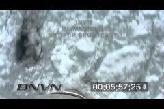
Footage of the ice crashing up against the bot of the Freighter Edward L. Ryerson.
Footage of the Edward L. Ryerson traveling through the ice pack on Lake Huron while passing under the Blue Water Bridge.
Includes time lapse of the Ryerson passing under the Blue Water Bridge.
Catalog #: EdwardLRyerson_ICE_Long_ET
Screen Format: 16:9
Video Format: Standard Definition
License Type: Rights Managed
To license this footage, contact http://www.StormChasingVideo.com
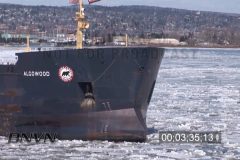
B-Roll footage of the Great Lakes Freighter Algowood sailing into port in Duluth, MN through large chunks of ice floating in the water.
Various tight and wide shots of the ship with ice hitting the bow and along side of the ship.
Catalog #: Algowood_Duluth_Ice_ET
Screen Format: 16:9
Video Format: High Definition
License Type: Rights Managed
To license this footage, contact http://www.StormChasingVideo.com
6/17/2010 Wadena, MN Tornado Aftermath B-Roll Video.
Footage shot right after a tornado hit the rural town of Wadena, MN and the first half of the video is POV B-Roll driving into the town.
The second half of the video is aftermath damage clips in the daylight hours as the rescue crews started to get on the scene.
Catalog #: 06172010_Tornado_TL1
Screen Format: 16:9
Video Format: High Definition
License Type: Rights Managed
To license this footage, contact http://www.StormChasingVideo.com
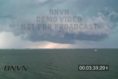
7/17/2010 Extreme Hail Storm and wall cloud footage from Minnesota.
A hail storm hit central Minnesota with baseball size hail that caught a lot of people off guard while heading home from their cabins in Northern Minnesota.
Footage while driving in hail and traffic stuck in hail as large hail stones fall on the road and various hail falling video clips.
Additional footage of a very large super cell Thunderstorm and Meso Cyclone over a lake with boaters trying to get off the lake before the storm hits.
Catalog #: 07172010A
Screen Format: 16:9
Video Format: High Definition
License Type: Rights Managed
To license this footage, contact http://www.StormChasingVideo.com
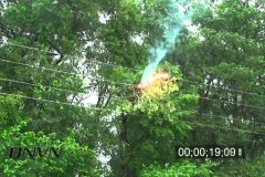
6/25/2010 Debris shorting out power lines footage
Footage of a tree limb broken off from the high winds of a severe thunder storm laying on some power lines. The tree limb was causing the high voltage power lines to short out and catch on fire while also making a huge power flash as the line short out.
Catalog #: 06252010B
Screen Format: 16:9
Video Format: High Definition
License Type: Rights Managed
To license this footage, contact http://www.StormChasingVideo.com
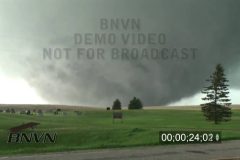
Amazing tornado outbreak video from northern South Dakota. Tony Laubach shot this large violent wedge tornado video three miles north of the town of Bowdle South Dakota. Footage zoomed in with close up shots of high tension power lines being hit by the tornado and crashing to the ground as the wedge tornado approached them. Video of the wedge tornado transitioning into a very stout cone tornado.
Catalog: 05222010_Tornado_TL
Total Run Time: 8;24;26
Format: HD
License Type: Rights Managed
To license this footage, contact http://www.StormChasingVideo.com
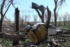
After the wedge tornado hit the area near Bowdle, SD on 5/22/2010, Tony Laubach shot some dramatic aftermath footage that shows broken and twisted cars and trucks that were picked up and thrown about in the tornado.
Additional footage of the aftermath of the destroyed high tension power lines that were smashed and laying in a field. Video of stripped trees and destroyed homes and buildings with flying debris stuck inside of walls and the other objects damaged.
Catalog: 05222010_Aftermath_TL
Total Run Time: 05;15;25
Format: HD
License Type: Rights Managed
To license this footage, contact http://www.StormChasingVideo.com
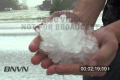
A severe thunderstorm exploded over the small town of Campo, CO in extreme southeast Colorado and dumped six inches of 1-inch hail along US-287 and US-385.
This insane storm poured hail for over 20 minutes and created a winter like scene in its wake.
The opening shots include two scenes of the hail falling with the Campo city limites sign.
Various shots of vehicles getting pounded in the hail during the storm, buildings as well as traffic driving while being hit hard during the hail storm.
Catalog #: 05152010_Hail_TL
Screen Format: 16:9
Video Format: High Definition
License Type: Rights Managed
To license this footage, contact http://www.StormChasingVideo.com
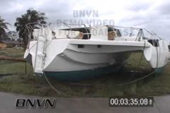
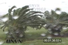
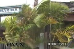
9/26/2004 Palm Bay Florida And Sebastian Florida Hurricane Jeanne Video. Footage after hurricane Jeanne from Palm Bay to Sebastian Florida with lots of building damage, destruction, power grid damage, squalls, a marina destroyed, and boats blown across US-1.
Catalog #: 20040926b_SSM
Screen Format: 4:3
Video Format: Standard Definition
License Type: Rights Managed
To license this footage, contact http://www.StormChasingVideo.com
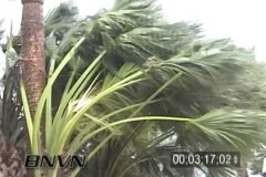
9/5/2004 Hurricane Frances Video In Sarasota FL. Footage from the bay front along the seawall with spray blowing and downed trees in the marina. Video of the squalls blasting Siesta Key and blasting the palm trees.
Catalog #: 20040905c_SSM
Screen Format: 4:3
Video Format: Standard Definition
License Type: Rights Managed
To license this footage, contact http://www.StormChasingVideo.com
9/5/2004 Hurricane Frances Video from Lakeland FL. Footage shot during Hurricane Frances in Lakeland FL. Video of guys trying to surf on an inland lake. Footage of buildings damaged by Hurricane Charley being damaged again by Hurricane Frances and having their blue roof tarps ripped off by the hurricane force winds.
Catalog #: 20040905a_SSM
Screen Format: 4:3
Video Format: Standard Definition
License Type: Rights Managed
To license this footage, contact http://www.StormChasingVideo.com
8/13/2004 Hurricane Charley Video, Port Charlotte And North Port FL. Footage from Port Charlotte and North Port Florida during Hurricane Cat4 Hurricane Charley. Video shot along I-75 at various exits near North Port FL. Also video of a mobile hurricane research tower near Venice FL.
Catalog #: 20040813a_SSM
Duration: 11:1 (661 seconds)
Screen Format: 4:3
Video Format: Standard Definition
License Type: Rights Managed
To license this footage, contact http://www.StormChasingVideo.com
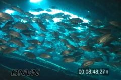
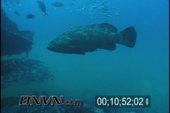
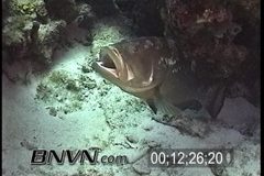
6/13/2004 Wreck Of The Bayronto Video. Sunk in 1919 in a storm and now it sites in 105 feet of water, the 400 foot long vessel sits upside down on the bottom of the Gulf Of Mexico. Footage includes massive schools of grunts or tomates and Goliath Groupers (Jewfish).
Catalog #: 20040613a_SSM
Screen Format: 4:3
Video Format: Standard Definition
License Type: Rights Managed
To license this footage, contact http://www.StormChasingVideo.com
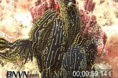
3/28/2004 Gulf Of Mexico Artificial Reef Video. Footage shot 15 miles off shore from Sarasota FL at an Artificial reef site.
Video includes Scamp, bridge rubble to make the reef, Blenny in a hole, Nudibranchs or Florida Regal Sea Goddesses feeding on a sponge.
Catalog #: 20040328c_SSM_16x9
Screen Format: 16:9
Video Format: Standard Definition
License Type: Rights Managed
To license this footage, contact http://www.StormChasingVideo.com
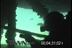
1/2/2004 Gulf Of Mexico Spear fishing Video. Footage of scuba divers spear fishing on an artificial reef of the Barge Wreck. Video includes penetration by divers to hunt for fish. Footage of a Goliath Grouper or Jewfish in side the wreck.
Catalog #: 20040102a_SSM
Screen Format: 4:3
Video Format: Standard Definition
License Type: Rights Managed
To license this footage, contact http://www.StormChasingVideo.com
9/1/2003 Gulf Of Mexico, Bayronto Wreck Video. Footage from the wreck of the Bayronto located 30 miles offshore from Sarasota FL. Video of scuba divers with spear guns, schooling grunts and tomates. Also includes wreck penetration and Goliath Groupers or Jewfish footage.
Catalog #: 20030901a_SSM
Screen Format: 4:3
Video Format: Standard Definition
License Type: Rights Managed
To license this footage, contact http://www.StormChasingVideo.com
5/31/2002 Dry Tortugas, FL scuba diving footage. Video from inside the Dry Tortugas Ecological Reserve of divers, coral reefs, reef inhabitants and a protective reef mooring system put in by NOAA. Also footage of Brain Coral, Plate Coral, sponges and barracudas.
Catalog #: 20020531a_SSM
Screen Format: 4:3
Video Format: Standard Definition
License Type: Rights Managed
To license this footage, contact http://www.StormChasingVideo.com
5/3/2002 Dry Tortugas, FL scuba diving video. Footage shot north and outside of the Tortugas Ecological Reserve. Scuba divers spear fishing, footage of French grunts, nurse sharks, groupers, coral reefs and close up of jelly fish.
Catalog #: 20020503a_SSM
Screen Format: 4:3
Video Format: Standard Definition
License Type: Rights Managed
To license this footage, contact http://www.StormChasingVideo.com
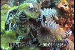
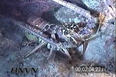
4/20/2002 Spiny Lobster and Cow Fish At Night Video. Footage of scuba divers at night off of West Palm Beach Florida while drift diving. Video of Spiny Lobsters and Cow Fish and Scuba Divers.
Catalog #: 20020420e_SSM
Screen Format: 4:3
Video Format: Standard Definition
License Type: Rights Managed
To license this footage, contact http://www.StormChasingVideo.com
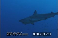
12/8/2001 West Palm Beach Florida Shark Dive Video. Footage while scuba diving and feeding sharks. Video of divers chumming to attract sharks before being outlawed by the fisheries department at the end of 2001.
Catalog #: 20011208a_SSM
Screen Format: 4:3
Video Format: Standard Definition
License Type: Rights Managed
To license this footage, contact http://www.StormChasingVideo.com
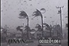
9/14/2001 Tropical Storm Gabrielle Video. Footage shot from Blackburn Point bridge and marina in the Vamo subdivision as Tropical Storm Gabrielle makes landfall.
Catalog #: 20010914a_SSM
Screen Format: 4:3
Video Format: Standard Definition
License Type: Rights Managed
To license this footage, contact http://www.StormChasingVideo.com
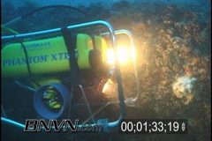
08/24/2001 Green Banana Sink And Research ROV video. Footage from 50 miles west of Sarasota Florida at the Green Banana Sink in the Gulf Of Mexico. Footage of research divers, ROV in action and divers spear fishing for Amberjack.
Catalog #: 20010824a_SSM
Screen Format: 4:3
Video Format: Standard Definition
License Type: Rights Managed
To license this footage, contact http://www.StormChasingVideo.com
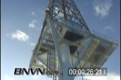
8/5/2001 Gulf Of Mexico – L-Tower Video. Footage from topside of the Air Force Radio Tower L-Tower that is 62 miles off shore of Naples Florida in the Gulf Of Mexico. Pre-Dive topside footage.
Catalog #: 20010805a_SSM
Screen Format: 4:3
Video Format: Standard Definition
License Type: Rights Managed
To license this footage, contact http://www.StormChasingVideo.com
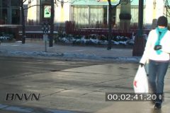
12/15/2009 Minneapolis, MN Sub Zero Video. B-Roll footage of people in downtown Minneapolis, MN with sub zero temps and even colder wind chills during the afternoon hours. News B-Roll Footage
Catalog #: 12152009A
Total Run Time: 4:42
Format: HD
Screen Format: 16:9
License Type: Rights Managed
To license this footage, contact http://www.StormChasingVideo.com