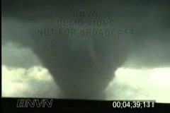
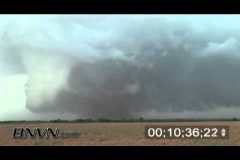
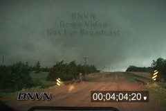
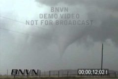
7/21/1993 Last Chance Colorado Tornado Video. Rare footage of the Last Chance Colorado tornado that is filmed prior to Storm Chasing becoming main stream. Video of a large wedge tornado that turns into a stove pipe tornado then transforms into a rope tornado before falling apart.
Catalog #: 07211993a_BR
Screen Format: 4:3
Video Format: Standard Definition
License Type: Rights Managed
To license this footage, contact http://www.StormChasingVideo.com
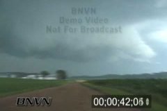
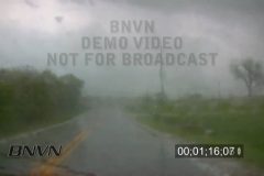
7/19/2003 Dark and ominous spinning cloud video. Dark and ominous spinning cloud under a severe thunderstorm.
Catalog #: 07192003a
Screen Format: 4:3
Video Format: Standard Definition
License Type: Rights Managed
To license this footage, contact http://www.StormChasingVideo.com
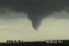
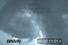
7/12/2004 Super cells And Tornado Footage. Video of super cells and tornadoes from North Central Nebraska.
Great video of a large funnel that touches down and starts kicking up debris. Rapid rotation of the tornado as hail falls on the storm chasers. Closeup tornado footage over open country.
Catalog #: 07122004_DC1
Screen Format: 4:3
Video Format: Standard Definition
License Type: Rights Managed
To license this footage, contact http://www.StormChasingVideo.com
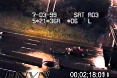
07/03/1999 Traffic Camera Catches Explosive Storm Sewer Flooding. MN Dot traffic camera video from 35th Street and Interstate 35W of the storm sewer during heavy rain. The heavy rain trapped air in the drain system causing it to push the water back up the storm sewer system and exploding straight up in the air like a geysers.
Catalog ID: 07031999MNDOT
To license this footage contact: http://www.bnvn.com
6/30/2005 Windy weather news video. People outside on a windy day in Minneapolis, MN with various video of people out in the wind with hair blowing around and blowing trash and debris. Footage shot for news B-Roll.
Catalog #: 06302005a
Screen Format: 4:3
Video Format: Standard Definition
License Type: Rights Managed
To license this news footage, contact http://www.StormChasingVideo.com
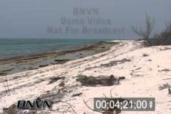
6/27/2007 Desert Island Beach Video. This footage is of a long static clip of a desert island beach with the waves. Video shot on Loggerhead Key in the Dry Tortugas National Park. Good audio of the ocean and waves with natural sound and no man mad objects.
Catalog #: 06252007a
Screen Format: 4:3
Video Format: Standard Definition
License Type: Rights Managed
To license this footage, contact http://www.StormChasingVideo.com
6/19/2005 Hot Weather Video. Hot weather footage from around Minneapolis. Video of people out around the lakes and trying to stay cool. Footage shot around Lake Calhoun and Lake Harriet in Minneapolis, MN. B-Roll Footage shot while working freelance for KSTP and Weather Channel.
Catalog #: 06192005a
Screen Format: 4:3
Video Format: Standard Definition
License Type: Rights Managed
To license this footage, contact http://www.StormChasingVideo.com
B-Roll footage of several tornadoes that formed around the Crosbyton and Spur Texas area. Some of the tornadoes lasted for several minutes. All various types of tornadoes formed with this storm system from wedge tornadoes to stove pipe and rope tornadoes and multi-vortex tornadoes and twin or dual tornadoes under the same wall cloud or base of the storm.
Catalog #: 06122005_CC_1
Screen Format: 16:9
Video Format: Standard Definition
License Type: Rights Managed
To license this footage, contact http://www.StormChasingVideo.com
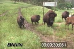
Buffalo Video, Buffalo Stampede Video from Custer State Park in the Black Hills of South Dakota. The Buffalo were spooked by the severe storms and started to run and they ran right across Highway 16. A park ranger said that this has never seen them do that before in such a huge massive numbers.
Looked like the Buffalo were running for their lives.
Catalog #: 06092006a
Screen Format: 4:3
Video Format: Standard Definition
License Type: Rights Managed
To license this footage, contact http://www.StormChasingVideo.com
6/9/2003 O’Neill Nebraska, Tornado Video. Footage of a half a mile wide F3 Tornado from a distance and as the outer edge of the tornadic winds hit the videographer who is parked on the edge of the tornado.
Catalog #: 06092003_TT1
Screen Format: 4:3
Video Format: Standard Definition
License Type: Rights Managed
To license this footage, contact http://www.StormChasingVideo.com
B-Roll footage of an overnight rain wrapped tornado hitting the southwest part of Omaha Nebraska in the town of Millard, NE just after midnight. The tornado caused major damage to several business’s and homes. The tornado damage also caused a gas leak to one building which had fire fighters blocking off the area and on standby incase of an explosion. Also video of a tornado siren sounding and power flashes from the tornado hitting the area and aftermath footage of the damage and rescue crews searching the area.
Catalog #: 06082008A
Screen Format: 4:3
Video Format: Standard Definition
License Type: Rights Managed
To license this footage, contact http://www.StormChasingVideo.com
6/2/1997 Weldona Colorado Tornado Video. Footage of a weak tornado near Weldona CO as it hits a farm. Close up shots of the tornado hitting buildings and farm equipment.
Catalog #: 06021997a_BR
Screen Format: 4:3
Video Format: Standard Definition
License Type: Rights Managed
To license this footage, contact http://www.StormChasingVideo.com
5/29/2004 Argonia Kansas Wedge Tornado Video. Great tripoded footage of a wedge tornado up close with a wide angle lens and close up shots while being chased by the tornado. Footage of a huge dark wedge tornado over open country.
Catalog #: 05292004_BN1
Screen Format: 4:3
Video Format: Standard Definition
License Type: Rights Managed
To license this footage, contact http://www.StormChasingVideo.com
5/23/2008 Quinter Kansas Wedge Tornado Video. Raw dash camera footage of the Quinter Kansas wedge tornado from May 23rd, 2008. Footage of about a mile wide tornado from about 100 yards away from the edge of the tornado. Video shows power lines falling on SUV and debris flying past the camera.
Catalog #: 05232008_Wedge_DK_Dash
Total Run Time: 13;49;20
Screen Format: 4:3
Video Format: Standard Definition
License Type: Rights Managed
To license this footage, contact http://www.StormChasingVideo.com
5/13/2009 Kirksville, Missouri Tornado Video. Footage while storm chaser shoots POV footage of a tornado develop as it becomes rain-wrapped and passes less then 1/8th of a mile in front of the car. A red Jeep in front of the videographer does not know what is happening and that there is a tornado in front of them and drives right into the tornado. Video of significant damage to the jeep and to some homes just after the tornado hit the area.
Catalog #: 05132009_SW
Screen Format: 16:9
Video Format: High Definition
License Type: Rights Managed
To license this footage, contact http://www.StormChasingVideo.com
5/8/2004 Severe Storm video that shows a wall cloud spinning overhead. Rapid Rotation under a wall cloud video. Footage of Emergency workers on the lookout for tornado development.
Catalog #: 05082004a
Screen Format: 4:3
Video Format: Standard Definition
License Type: Rights Managed
To license this footage, contact http://www.StormChasingVideo.com
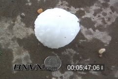
5/5/2006 Seminole Texas Massive Hail Storm Video. A massive hail storm with baseball sized hail and larger, hits the Seminole Texas region. The video was shot under a covered driveway for protection from the hail as the huge hail stones fall from the sky for several minutes.
Catalog #: 05052006_DC1
Screen Format: 4:3
Video Format: Standard Definition
License Type: Rights Managed
To license this footage, contact http://www.StormChasingVideo.com
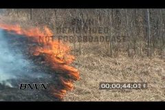
4/17/2009 Prescribed Burn Grass Fire Footage. With fire dangers in the area under control due to higher humidity, the Sherburne National Wildlife Refuge decided that it was a good window of opportunity for a prescribed burn to try and eliminate a potentially explosive situation.
Catalog #: 04172009A
Total Run Time 07;21;26
Screen Format: 16:9
Video Format: High Definition
License Type: Rights Managed
To license this footage, contact http://www.StormChasingVideo.com
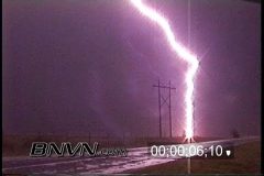
4/10/1995 Very close lightning strike video. Footage of a very close lightning strike that hits a power pole less then 100 yards away from the camera.
Catalog #: 04101995a1_DC
Screen Format: 4:3
Video Format: Standard Definition
License Type: Rights Managed
To license this footage, contact http://www.StormChasingVideo.com
04/05/2008 Tour Bus Crash Aftermath Footage. B-Roll footage of the aftermath of a fatal bus crash on Interstate 94 in Albertville, MN.
Catalog #: 04052008A
Screen Format: 4:3
Video Format: Standard Definition
License Type: Rights Managed
To license this footage, contact http://www.StormChasingVideo.com
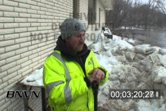
3/26/2009 Moorhead, MN Flooding – Part 2 – Fighting the flooding in Moorhead, MN at the home of Creek Kuser. Footage shot at the home which is along the Red River in the Moorhead Country Club area. Interview and B-Roll footage shot from the back yard with the flood waters trying to get into the home through a sand bag levee while pumps remove water that leaked in through the levee.
Catalog #: 03262009_Flooding_HD_Part_02
Screen Format: 16:9
Video Format: High Definition
License Type: Rights Managed
To license this footage, contact http://www.StormChasingVideo.com
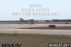
3/20/2004 Cessna 310 Plane Crash Video. Footage shot at the City of West Chicago, DuPaige Airport of a Cessna 310 coming in to make an emergency landing on Runway 33 with it’s nose gear stuck in the up position. The Plane comes in and lands on the two main landing gears then smashes down on it’s nose and twin props which strike the runway. Also B-Roll of people and EMS crews on the scene as well as aftermath footage.
Catalog #: 03202004a_JS
Screen Format: 4:3
Video Format: Standard Definition
License Type: Rights Managed
To license this footage, contact http://www.StormChasingVideo.com
3/14/2003 Mountain View OK Tornado Video. Footage of a tornado over open country in rural Oklahoma.
Catalog #: 03142003a_dc
Screen Format: 4:3
Video Format: Standard Definition
License Type: Rights Managed
To license this footage, contact http://www.StormChasingVideo.com
B-Roll footage of a semi truck blown over by high winds during an after dark tornado. Shot POV dash camera while driving as a weak tornado passed over a semi truck in front of the cameraman and flipped the truck on it’s side.
Catalog #: 03091998_CC_1
Screen Format: 16:9
Video Format: Standard Definition
License Type: Rights Managed
To license this footage, contact http://www.StormChasingVideo.com