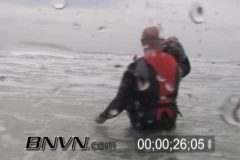
10/22/2005 Siesta Key Beach, Hurricane Wilma Approaches Southwest Florida. Hurricane Wilma is still 2 days away but the storm is still sending large swells to the Northeast. In water with high-surf, surge and wave crash shots. Video of surfers in the Gulf Of Mexico.
Catalog #: 20051022b_SSM_Wilma
Screen Format: 4:3
Video Format: Standard Definition
License Type: Rights Managed
To license this footage, contact http://www.StormChasingVideo.com
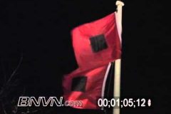
10/24/2005 Footage of Hurricane Wilma nearing Marco Island Florida. Hurricane flags blowing in the wind.
Catalog #: 20051024b_SSM_Wilma
Screen Format: 4:3
Video Format: Standard Definition
License Type: Rights Managed
To license this footage, contact http://www.StormChasingVideo.com
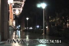
10/24/2005 Footage from Naples Florida as Hurricane Wilma approaches. As Hurricane Wilma is approaching Naples Florida, video of rain, deserted streets, news crews and police.
Catalog #: 20051024a_SSM_Wilma
Screen Format: 4:3
Video Format: Standard Definition
License Type: Rights Managed
To license this footage, contact http://www.StormChasingVideo.com
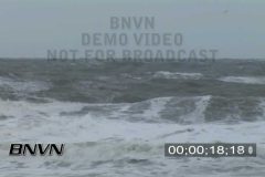
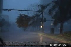
B-Roll Footage of Hurricane Noel that was offshore from Virginia Beach, VA. It created large waves that crashed on the beach. Video of people walking on the beach and surfers in the rough surf. Large white capped waves coming onshore and hitting pier. Lots of storm surge. Part 1 of 2.
Screen Format: 16:9
Video Format: High Definition
License Type: Rights Managed
Catalog #: 11022007_NOEL_1_HC_WC
To license this footage, contact http://www.bnvn.com
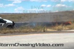
Extreme fire danger in Colorado today was creating very favorable conditions for the development and spreading of wildfires in the mountains and along the Front Range. BNVN Weather Paparazzi Tony Laubach was covering the Red Flag Warnings and Fire Weather Watches that have been posted because of the extremely dry conditions. The fires start easily due to the dry conditions and the fire featured in this video package, likely started by someone throwing a cigarette butt out of their window.
The fire started at roughly 12:15pm and was contained by 12:50pm; we arrived on-scene at 12:25pm and reported the fire to 9-1-1 with crews arriving at approximately 12:35pm. Video package shot in the center median of I-25 in Larimer County, Colorado near Mile Marker 290 north of Wellington (south of Carr exit). The fire ultimately burned just under a quarter mile long path of brush in the center median. No damage or injuries were reported with this fire.
Video package opens up with gusty winds pushing tall, fast moving flames north along I-25 through the dry brush in the interstate median. Various other clips of the fire as it burns between the interstate with passing traffic driving by. Also included is a shot of northbound traffic with the heat from the flames blurring out the cars. Midway through, a fire fighter arrives and starts spraying a mix of water and flame retardant on the flames to quickly put the fire out. One of the fire fighters gets out and starts covering hot spots with dirt using a shovel. Fire is quickly put out by the truck and 2-man crew.
To license this footage, contact http://www.stormchasingvideo.com
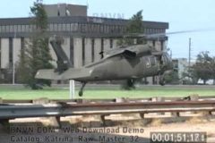
8/30/2005 Footage shot at Interstate 10 and Causeway Overpass of Coast Guard and National Guard helicopters landing and dropping off people who were rescued from their roof tops in New Orleans. Footage shows the massive rescue effort that was happening as survivors were waiting for additional buses to transport them to shelters outside of the devastated area. Footage ends with an interview of a man that asked for a ride from the photographer to try and get to his mothers home to take shelter in the city of Kenner, LA. The interview explains what happened to him which is pretty much the same story for most of the survivors of Hurricane Katrina in the New Orleans, LA area. Catalog ends with non flooding storm damage along Airline Highway.
Catalog ID: Katrina_Raw_Master_32
Total Run Time: 12;05;17
To license this footage, contact http://www.StormChasingVideo.com
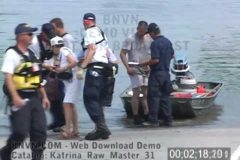
8/30/2005 B-Roll Footage shot at Interstate 10 and 610 interchange which became a boat ramp rescue launching point for those needing to be rescued from the massive flooding that devastated the New Orleans, LA metro area. Video shots include FEMA rescue workers bringing people by boat to the staging area. Footage of the New Orleans skyline overlooking Interstate 10 which was not covered by several feet of flood water and close up shots of a pumping station surrounded by flood waters. Additional B-Roll clips showing FEMA personnel setting up rescue operations and some of the first buses to come and take people out of the area. Catalog includes an interview with a woman that was rescued and a man that brought his boat to come and help out the rescue efforts.
Catalog ID: Katrina_Raw_Master_31
Total Run Time: 13;13;19
To license this footage, contact http://www.StormChasingVideo.com
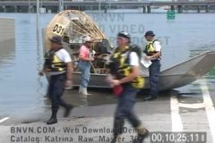
B-Roll footage of people who were just rescued with their pets from the flooding around New Orleans, LA with interviews of people telling their story about how they were rescued. Also includes shot of additional EMS personnel setting up, aerial shots from a bridge of cars underwater and air bubbling up to the surface. Additional B-Roll video includes the Pontchartrain Expressway pumping station surrounded by water with the New Orleans, LA skyline in the distance with a flooded out Interstate 10 in the foreground. Also footage of rescue boats bringing survivors to the staging area before being bussed out of the area.
Catalog ID: Katrina_Raw_Master_30
Total Run Time: 13;57;06
To license this footage, contact http://www.StormChasingVideo.com
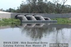
8/30/2005 B-Roll footage from Williams Blvd. and Veterans Blvd in Kenner, LA of people walking through the flooded roadway to try and get to the airport to be evacuated while others are checking out the damage and flooding. Video catalog then continues at the Orleans Parish line overlooking the 17th Street Canal and Pontchartrain Expressway pumping station pipes. This is where the massive interstate 10 and 610 rescue effort was being setup. B-Roll video of rescue crews from as far away as Kentucky and Missouri along with the National Guard and FEMA were organizing the massive overwhelming task of trying to search and rescue people from the flooded out metro area.
Catalog ID: Katrina_Raw_Master_29
Total Run Time: 12;41;26
To license this footage, contact http://www.StormChasingVideo.com
8/29/2005 B-Roll footage of the aftermath from Kenner, LA that was shot around the New Orleans, LA International Airport and shows the damage to the security fence, main terminal and vehicles in the parking ramp and hangers. Footage also shot inside the airport of people taking shelter who were waiting to be evacuated. Clips of people sleeping on the floor and an interview with a family from France that was stranded at the airport while trying to evacuate.
Catalog ID: Katrina_Raw_Master_27
Total Run Time: 12;33;06
To license this footage, contact http://www.StormChasingVideo.com
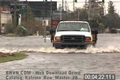
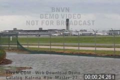
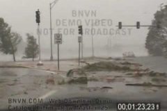
8/29/2005 B-Roll aftermath footage shot around the New Orleans, LA International Airport that shows the huge difference in the damage depending on the location around the metro area. On the south side of the airport along Airline Highway, there is no flooding, only damage from the high winds. While the south side of the airport was high and dry, the north side of the airport at Williams Blvd. and Veterans Blvd. was flooded with several feet of water and the water was still rising. Footage includes cars floating in the high water and people walking in the high water while large police truck drive through the flooded roadways.
Catalog ID: Katrina_Raw_Master_28
Total Run Time: 10;49;29
To license this footage, contact http://www.StormChasingVideo.com
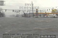
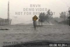
8/29/2005 Raw B-Roll footage shot at Interstate 10 and Williams Blvd just north of the New Orleans, LA International Airport that shows the massive flooding from Hurricane Katrina’s heavy rains. The water is several feet deep in places and cut off access to the airport via Williams Blvd. Catalog ends with footage of a home destroyed by Katrina’s high winds in Kenner, LA.
Catalog ID: Katrina_Raw_Master_26
Total Run Time: 11;36;29
To license this footage, contact http://www.StormChasingVideo.com
8/29/2005 Raw B-Roll POV footage through Metairie, LA through the flooding and debris on Veterans, Blvd. to Causeway Expressway that shows the several feet of water in areas on the road as the flooding was just beginning. Footage of flying debris slamming into the front of the SUV while entering Interstate 10 and followed with video of debris covering Interstate 10 and ended with overview of the New Orleans International airport field being flooded by the heavy rains and damaged by the high winds.
Catalog ID: Katrina_Raw_Master_25
Total Run Time: 14;33;22
To license this footage, contact http://www.StormChasingVideo.com
8/29/2005 Raw B-Roll POV footage shot during the escape from New Orleans, LA as the cameraman drives through the city of Metairie, LA and dodges debris and downed trees, power lines and flying shrapnel. Footage shot POV thought most of Metairie, LA to Bonnabel Blvd. entrance on Interstate 10. This entrance was also blocked by debris and flood waters. After finding the freeway entrance was blocked, the footage continues on back streets to Veterans Blvd and Helios Avenue.
Catalog ID: Katrina_Raw_Master_24
Total Run Time: 12;46;28
To license this footage, contact http://www.StormChasingVideo.com
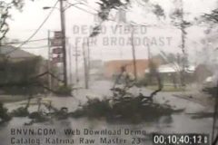
8/29/2005 Raw B-Roll POV footage shot as the flood waters were starting to rise in New Orleans as the cameraman tries to get out of the city before it is submerged. Video starts at the South Carrolton Avenue entrance of Interstate 10 and goes up to the railroad underpass that flooded out with at least six feet of water by 9:00 a.m. The POV footage continues as the cameraman makes the escape through Metairie, LA on Metairie Road while navigating through the downed trees and fallen power lines and flying debris.
Catalog ID: Katrina_Raw_Master_23
Total Run Time: 12;38;04
To license this footage, contact http://www.StormChasingVideo.com
8/29/2005 Raw B-Roll footage shot during the escape from New Orleans, LA as the city begins to flood from Hurricane Katrina as the levees failed. Footage shot on the western side of the eye wall as New Orleans, LA is still being slammed by the hurricane force winds. POV Footage with flying debris as the cameraman navigates through the flooding to try and get out of the city before being trapped by the rising flood waters. Footage from St. Bernard Avenue and North Claiborne Avenue to Canal Street, then over to Tulane Avenue and Broad Street. Then the drive continues at Earhart Blvd and Washington Ave as the Washington Avenue Canal spills over its banks. Video ends at the South Carrollton Avenue entrance to Interstate 10.
Catalog ID: Katrina_Raw_Master_22
Total Run Time: 10;50;22
To license this footage, contact http://www.StormChasingVideo.com
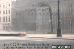
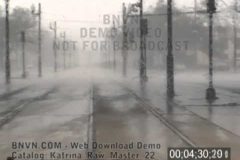
8/29/2005 Raw B-Roll footage of shot on Canal and Camp Streets in downtown New Orleans, LA that was shot outside of the Marriott hotel showing high winds ripping apart the downtown area while a lone police car is patrolling the area.
Catalog ID: Katrina_Raw_Master_18
Total Run Time: 11;17;28
To license this footage, contact http://www.StormChasingVideo.com
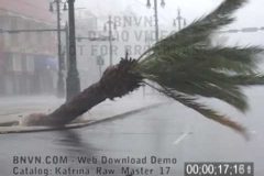
8/29/2005 Raw B-Roll footage of Hurricane Katrina on Canal Street. POV footage driving on Canal Street in the middle of Hurricane Katrina with high winds and debris flying through the air as palm trees on Canal Street were knocked over and blocking the road. Video continues outside of the Marriott hotel on Canal Street with EMS personnel watching the city being devastated by the hurricane. Video of a man holding onto a light pole in the high winds on Canal Street and footage of parts of downtown buildings roofs being blown off and destroyed in the hurricane.
Catalog ID: Katrina_Raw_Master_17
Total Run Time: 13;25;20
To license this footage, contact http://www.StormChasingVideo.com
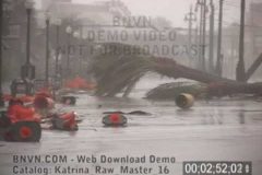
8/29/2005 Hurricane Katrina, New Orleans, LA – Video on Canal Street and North Peter Street. Footage of hurricane force winds from Katrina slamming into the downtown area across the street from Harrah’s Casino and Hotel on Canal Street. Raw footage with lots of high winds and debris flying through the air as the hurricane winds rip apart the city.
Catalog ID: Katrina_Raw_Master_16
Total Run Time: 14;14;21
To license this footage, contact http://www.StormChasingVideo.com
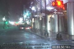
8/29/2005 Raw B-Roll footage in the pre dawn hours with POV video on Canal Street in the middle of Hurricane Katrina. Tripoded footage on Canal Street at Rampart Street of debris flying around and falling on the streets. Footage of a police squad car driving on Canal Street in the middle of the storm through the debris and video of a billboard being ripped apart by the wind.
Catalog ID: Katrina_Raw_Master_13
Total Run Time: 14;48;23
To license this footage, contact http://www.StormChasingVideo.com
8/29/2005 Raw B-Roll POV footage shot at dawn as Hurricane Katrina’s western eye wall moves closer to the downtown area. Footage shot from Poydras and South Rampart to Canal Street as debris is flying through the air and trees are falling down and blocking the roadway.
Catalog ID: Katrina_Raw_Master_15
Total Run Time: 10;04;24
To license this footage, contact http://www.StormChasingVideo.com
8/29/2005 Raw B-Roll footage of Hurricane Katrina shot during the predawn hours in New Orleans, LA. Video of POV shots and tripoded shots in downtown New Orleans, LA around the French Quarter, Canal Street and includes footage of the police still out on patrol during the hurricane. Last part of the video catalog includes footage of hurricane force winds on Carondelet Street at the intersection of Common Street.
Catalog ID: Katrina_Raw_Master_12
Total Run Time: 11;38;04
To license this footage, contact http://www.StormChasingVideo.com
8/29/2005 Raw B-Roll footage of Hurricane Katrina POV video shot while driving on Tulane Avenue into downtown New Orleans, LA. Footage is then shot outside in the hurricane force winds at the intersection of O’Keefe Avenue and University Place.
Catalog ID: Katrina_Raw_Master_11
Total Run Time: 12;25;24
To license this footage, contact http://www.StormChasingVideo.com
8/29/2005 Raw B-Roll footage of Hurricane Katrina shot during the early morning hours in downtown New Orleans, LA. POV shots of driving on Interstate 10 as cameraman drove into the city and shots along Tulane Avenue at South Lopez as the heavy rain starts to flood the residential area.
Catalog #: Katrina_Raw_Master_10
Total Run Time: 13;06;03
Screen Format: 4:3
Video Format: Standard Definition
License Type: Rights Managed
To license this footage, contact http://www.StormChasingVideo.com