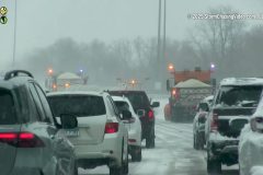
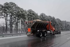
A winter storm tracked through the Twin Cities Tuesday night into Wednesday morning, March 4-5, 2025, bringing 7-12 of snow across the region and being one of the biggest snowfalls of the season, and blizzard-like conditions. Several schools across the area were closed due to hazardous travel conditions on Wednesday morning. The following video was captured across Dakota and Hennepin counties, showing the impacts on the Wednesday morning commute across the region. Minnesota State Patrol reported hundreds of spin-outs and vehicles stuck in the snow, as MnDOT crews and city crews worked hard to get roads cleared by late morning.
Shot Description
00:00 Video of a Minnesota State Patrol Trooper sitting with a vehicle on southbound I-35E in Eagan, MN that had gone into the ditch.
00:10 Various clips from Lakeville, MN, show people attempting to help pull a woman's vehicle out of a snow drift. The clips include pulling the vehicle out using a pull rope and people shoveling snow out from underneath and around the vehicle.
00:47 Video of a roadside on northbound Highway 77 in Apple Valley, MN, saying Winter Storm Warning in Effect with snow-covered roads, falling snow, and slow driving traffic.
00:57 Video of a vehicle on the ramp from northbound Highway 77 to northbound I-35E in Apple Valley stuck in the ditch.
01:08 One close-up and one wide shot of a digital sign saying Winter Storm Warning in Effect on northbound I-35W into Minneapolis, MN.
01:23 One close-up and one wide shot of a digital sign saying Crash -Ramp Closed to 494 West Use Alternative Route on northbound I-35W going through Bloomington, MN.
01:33 Medium shot of slow traffic behind a MnDOT snow plow gang clearing the highway from the heavy snow in Minneapolis, MN.
01:46 A couple of clips of a snow plow gang clearing the highway going around a curve in Minneapolis, MN.
02:20 Video of snow plows going around a vehicle stuck or broken down on the side of the road in Minneapolis, MN.
02:38 Additional close to medium shot video clips following behind MnDOT snow plows clearing the highway of the heavy snow.
02:53 Medium to wide shot of traffic slowing driving toward the City of Minneapolis, city in the background as snow falls and an MVTA bus in the foreground along I-35W.
03:01 Close-up video of an MnDOT plow and trailer clearing the road of heavy snow and putting down deicer driving into Minneapolis, MN from northbound I-35W.
03:09 Medium shot video in Minneapolis, MN of snow falling and blowing, causing reduced visibility near Hennepin Ave.
03:18 Video of people shoveling the heavy snow in downtown Minneapolis, MN in the strong winds and blowing snow.
SID: Hunter Anderson Will Wight
To help support our freelancers, buy them coffee. https://www.buymeacoffee.com/stormchasing/
To License This Footage For Broadcast, Contact Video @ StormChasingVideo.com
Our Team Merch Store – https://stormchasingvideo.creator-spring.com
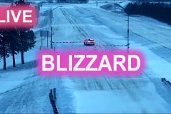
Blizzard conditions on I-35 and US-52 in southern Minnesota March 5 2025. Local PS radio.
#mnwx
#weather
#blizzard
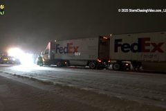
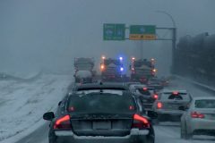
Scenes from the travel nightmare from the powerful winter storm hitting the Twin Cities Metro area. Footage of aircraft deicing at the Minneapolis – St. Paul International Airport in near whiteout conditions. Scenes from the roads of extremely dangerous driving conditions, such as snow-packed roads and icy conditions. Numerous motor vehicles crashed, spun out, and got stuck in the snow.
Shot Description
Clip 1 – Winter Storm Warning Sign.
Clip 2 – Pickup truck spinning its wheels.
Clip 3 – Big Rig Tractor spun out and crashed into the ditch along Interstate 35.
Clip 4-5 – FedEx Tractor Trailer stuck on an exit ramp on Interstate 35 in the heavy snow and high winds.
Clip 6-7 – Amazon Prime Tractor Trailers crashed into the ditch on Interstate 35.
Clip 8-11 – Cars sliding on the ice and snow on Nicollet Avenue in Burnsville, MN.
Clip 12 – Snow Plow moving towards the camera.
Clip 13-15 – Scenes of Aircraft Deicing at Minneapolis International Airport.
Clip 16 – Pickup truck pulling a trailer and spinning its wheels on Interstate 35.
Clip 17 – Pickup truck crashed into the ditch.
Clip 18 – Snow Plows.
Clip 19 – Tow truck pulling a car out of the ditch.
Clip 20 – SUV in the ditch.
Clip 21-22 – Car stuck in the ditch.
Clip 23 – SUV Stuck in the ditch.
Clip 24-26 – Snow plows on Interstate 35.
#mnwx #winterstorm #blizzard #automobile
To help support our freelancers, buy them coffee. https://www.buymeacoffee.com/stormchasing/
To License This Footage For Broadcast, Contact Video @ StormChasingVideo.com
Our Team Merch Store – https://stormchasingvideo.creator-spring.com
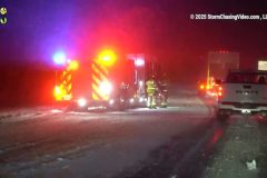
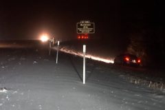
Blizzard Warning, multiple accidents, whiteout conditions, power flashes, high winds, blowing snow, and very dangerous driving conditions over Western Iowa during a powerful spring blizzard.
All footage shot during evening darkness on March 4, 2025 in/near Nebraska City, Nebraska by meteorologist and Storm Chaser Simon Brewer
Shot Description
00:00 power flash takes out lights
00:15 large multivehicle accident with significant emergency personnel presence blocks Interstate 29
00:58 snowplow clears snow on I-29
01:18 high winds blowing snow
01:58 whiteout conditions and power flash over highway
02:15 high winds blowing snow
SID: Simon Brewer
#iawx #winterstorm #blizzard
To help support our freelancers, buy them coffee. https://www.buymeacoffee.com/stormchasing/
To License This Footage For Broadcast, Contact Video @ StormChasingVideo.com
Our Team Merch Store – https://stormchasingvideo.creator-spring.com
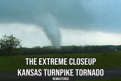
The famous Kansas Turnpike Tornado was filmed during the historic May 4th, 2003 tornado event. The footage was shot just west of Kansas City, KS, in Wyandotte, KS. As the tornado moved to the northeast, it passed about 50 yards away, and debris fell on the cameraman.
The footage continues as the cameraman chases the tornado on foot to get up to the bridge and then finds a family hiding in the worst possible place under the bridge. Footage ends as the tornado moves along Interstate 70 and towards the Kansas Speedway.
Catalog: 05042003_Remastered_Edit_2025
Format: ProRes 422HQ 1920×1080
#Kansas #Turnpiketornado #Tornado #stormchasing #KSWX
To help support our freelancers, buy them coffee. https://www.buymeacoffee.com/stormchasing/
To License This Footage For Broadcast, Contact Video @ StormChasingVideo.com or www.Aftermathvideo.com
Our Team Merch Store – https://stormchasingvideo.creator-spring.com
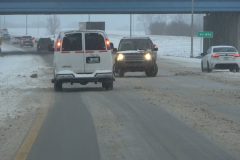
Multiple accidents from heavy snow during winter storms on Lexington, Kentucky highways still reeling from significant flooding.
All footage was shot during morning daylight on February 19, 2025, in/near Lexington, Kentucky, by Meteorologist and Storm Chaser Simon Brewer.
Shot Description
00:00 SUV spins-out on snow in the middle of Interstate 75 in Lexington, Kentucky
00:18 Multiple accidents from snow-covered highways with emergency assistance
01:04 tractor trailer accident from snow-covered highway, losing trailer
01:43 Truck slides ona snowy highway
02:09 snowplows clear snow from highways
SID: Simon Brewer
#KYWX #weather #winterstorm
To help support our freelancers, buy them coffee. https://www.buymeacoffee.com/stormchasing/
To License This Footage For Broadcast, Contact Video @ StormChasingVideo.com
Our Team Merch Store – https://stormchasingvideo.creator-spring.com
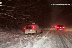
Winter storm hits Western Kentucky still reeling from tragic flooding.
All footage shot during evening darkness on February 18, 2025 in/near Elizabethtown, Kentucky by Meteorologist and Storm Chaser Simon Brewer
Shot Description
00:00 vehicles in ditch after sliding off snow-covered highway
00:28 snowplows clear Interstate 65
01:04 traffic with heavy snow falling
01:13 heavy snow falling at gas station
01:26 traffic lights with heavy snow falling
SID: Simon Brewer
#KYWX #Winterstorm #Snowstorm #weather
To help support our freelancers, buy them coffee. https://www.buymeacoffee.com/stormchasing/
To License This Footage For Broadcast, Contact Video @ StormChasingVideo.com
Our Team Merch Store – https://stormchasingvideo.creator-spring.com
Winter Storm brings Hazardous Travel to the Baltimore Area
Shot Description
00:00 Car almost loses control across bridge near Baltimore
00:08 (3 Clips) Vehicles slid off the road in the ditch or median just outside Baltimore, Maryland from Winter Storm
00:39 Car off the interstate with plows clearing the roadway
00:48 Two plows clearing the interstate with heavy snow falling
00:57 EMS attending to a vehicle off the roadway during the dangerous winter storm
01:06 Two plows trying to clear roadway in downtown Baltimore
01:13 Downtown Baltimore snow storm with train moving through town
01:28 Still shot of downtown Baltimore with snow coming down
01:35 Extremely heavy traffic on snow covered interstate in Baltimore, MD
01:47 Plows clearing roadway with traffic alert sign
01:58 Still shot of snow falling in Baltimore
02:05 Dangerous travel on interstate with heavy snow falling
SID: Michael Gordon
#winterstorm #MDWX #automobile
To help support our freelancers, buy them coffee. https://www.buymeacoffee.com/stormchasing/
To License This Footage For Broadcast, Contact Video @ StormChasingVideo.com
Our Team Merch Store – https://stormchasingvideo.creator-spring.com
Winter storm in Richmond, Virginia with snow, sleet and freezing rain. Scenes of a wrecked truck, snow plow, kids sledding and people dealing with the winter weather.
Shot Description
Wrecked truck and emergency vehicles on I-64
Snow plow sanding Interstate 64
Kids sledding
A couple walking in a snowy neighborhood
Workers shoveling a walkway
Person walking dog
SID: William Hark
#Vawx #winterstorm #weather #snowstorm
To help support our freelancers, buy them coffee. https://www.buymeacoffee.com/stormchasing/
To License This Footage For Broadcast, Contact Video @ StormChasingVideo.com
Our Team Merch Store – https://stormchasingvideo.creator-spring.com
Minneapolis and St. Paul metro experienced one of the more significant snow storms of the 2024-25 winter season. The northern metro was hit the hardest with up to a half foot of snow. This caused plenty of chaos across the metro this morning, perhaps catching some motorists off-guard.
Shot Description
00:00 Various clips of Minneapolis Public Works crew shoveling snow on the sidewalk
00:15 A couple of clips of a Bobcat brushing snow off the sidewalk in Minneapolis.
00:45 Driving shot of snow falling on I-35W in Minneapolis.
00:54 Close clips following and passing a snow plow.
01:15 Video of a spun-out truck and tow truck off the shoulder of an on-ramp to I-35W.
01:24 Various follow shots of traffic behind snow plow armada in the Twin Cities.
01:47 Various shots of heavy snow falling onto I-94 traffic
02:21 Snow falling in front of red pole barn
02:31 Various shots of snow plows clearing the taxiway at Lake Elmo Airport.
03:49 Large snowflakes falling in front of interstate exit signs.
03:55 Video of a spun-out car in a ditch.
03:59 Heavy snow falling on I-94 featuring Minneapolis highway sign.
04:06 Drive-by of accident on I-35W.
04:12 A couple of tight shots following snow plows in Minneapolis.
04:36 A few shots from the accident scene on I-35W with the vehicle getting towed.
04:50 Same location as the last scene, but slow drive-by of vehicle getting towed.
05:04 Video from the University of Minnesota of a student walking on the road in Heavy snow.
05:12 Various clips of dogs and their owners taking in the snowfall.
05:28 Friends walking on the sidewalk amidst improving snowfall.
#MNWX #winterstorm #snowstorm #badroads
To help support our freelancers, buy them coffee. https://www.buymeacoffee.com/stormchasing/
To License This Footage For Broadcast, Contact Video @ StormChasingVideo.com
Our Team Merch Store – https://stormchasingvideo.creator-spring.com
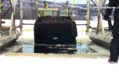
Today, February 03, 2025, crews from the St. Louis Sheriff’s Office and their water rescue team, along with the Superior/Douglas County WI. Dive and Rescue team and another team from Ely, MN, recovered a Jeep that had been missing for over 13 years from the St. Louis River/Sprite Lake.
The vehicle was reported stolen back in February of 2012. The teams had no idea if a person was in the Jeep. Thankfully, no human remains were found, and it appears that the Jeep was just dumped in the water after being stolen in 2012.
The vehicle was submerged in 20 feet of water. This video package will show the recovery of the Jeep.
Shot Description
Clip 1. The crew cut the ice to recover the Jeep.
Clip 2. Another crew pushed the ice chunks under the main sheet of ice.
Clip 3. A diver goes into the water to hook up the chains to the front of the Jeep.
Clips 5-6. The crew lifted the front end of the Jeep out of the water.
Clips 7-8. Two divers headed into the water to hook up the rear end of the Jeep.
Clips 9-11. The crew pulled the Jeep out of the water.
Clip 12. The crew pulled the ice recovery equipment away from the Jeep.
SID: Dirk Miller
To help support our freelancers, buy them coffee. https://www.buymeacoffee.com/stormchasing/
To License This Footage For Broadcast, Contact Video @ StormChasingVideo.com
Our Team Merch Store – https://stormchasingvideo.creator-spring.com
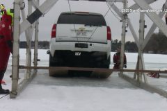
The ice is never 100% safe to drive on, even in the middle of winter in the upper Midwest, because warmer temperatures have caused the ice to shift and create pressure ridges where the ice becomes thinner.
Footage shows the recovery of two vehicles from two different lakes in Barron County, Wisconsin.
The first part of the video was shot in Cameron, Wisconsin. Yesterday afternoon, a Chevy Suburban broke through ice on Prairie Lake near Cameron, WI. The Suburban drove over a pressure ridge that had formed between an island and the main shoreline of the lake. The water in this spot was around 3 feet deep, as there was a sandbar on which the pressure ridge formed. No injuries were reported. This video package will show the recovery of the suburban on this windy afternoon.
The second vehicle was in Chetek, Wisconsin, where a Toyota truck went through the ice on Chetek Lake. The truck went through the pressure ridge by the Highway D bridge. No injuries were reported. The vehicle was sitting in about 4 to maybe 5 feet of water.
Most of the area lakes have about 16 to 20 inches of ice on them, but due to the underwater currents and the freezing and thawing with the record-warm temperatures this year, many lakes have pressure ridges hidden in the ice.
Shot Description
From Cameron, Wisc.
Clip 1. The crew formed a game plan.
Clip 2. The Suburban is waiting to be rescued.
Clip 3. Crew cutting the ice away from the suburban.
Clips 4-5. The crew pulled the Suburban out of the water.
Clip 6. Pulling the Suburban away from the hole in the ice.
From Chetek, Wisc.
Clip 7. Crew cutting the ice away from the truck.
Clip 8. Crew hooking up the chains to the truck.
Clips 9-10. The crew pulled the truck out of the water.
Clip 11. The crew pulled the equipment through the shot.
SID: Dirk Miller
#icefishing #iceroad #icerecovery #towtruck
To help support our freelancers, buy them coffee. https://www.buymeacoffee.com/stormchasing/
To License This Footage For Broadcast, Contact Video @ StormChasingVideo.com
Our Team Merch Store – https://stormchasingvideo.creator-spring.com
Intense wind driven snow causes chaos on I-25 north of Colorado Springs, Colorado on Jan. 30, 2025.
Southern Colorado (Local market exclusive to KKTV)
Shot Description
00:00 – CDOT workers pull a box truck up an off-ramp from I-25 northbound onto Baptist Rd. in Monument, Colo.
00:28 – Same location as last, truck slides as it vanishes into low visibility.
00:42 – Overview of the previous scene, before towing with traffic and other vehicles stuck on the off-ramp, blowing snow with limited visibility.
00:53 – Tighter, closer to the previous scene, before tow, with traffic backed up and CDOT workers showing up to help.
00:59 – CDOT workers hooking up tow strap.
01:07 – Blowing snow as people stand outside next to stuck trucks, with CDOT vehicle responding.
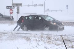
01:27 – Good Samaritan pushing stuck vehicle in intense wind driven snow.
02:11 – CDOT truck pulling semi with tow strap.
02:29 – Sedan sideways, stuck on off-ramp, spinning tires.
02:52 – Wide of slow traffic in limited visibility and blowing snow on I-25 northbound in Monument, Colo.
03:04 – Mid of last.
03:22 – Wide of CDOT truck and stuck semi in low visibility wind driven snow.
03:33 – Tight of last.
03:42 – Delivery trucks in zero visibility emerge from a blanket of blowing snow.
04:36 – Flags in blowing snow, wide.
04:44 – Tight of flags in blowing snow.
04:52 – Tight shot of gas station in zero visibility blowing snow.
05:01 – Field with blowing snow.
05:11 – Tight shot of a field with blowing snow.
05:24 – Overview of Baptist Rd. in Monument, Colo during snowfall.
SID: Trevor Cokley
Edit Shot Sheet Info
To help support our freelancers, buy them coffee. https://www.buymeacoffee.com/stormchasing/
To License This Footage For Broadcast, Contact Video @ StormChasingVideo.com
Our Team Merch Store – https://stormchasingvideo.creator-spring.com
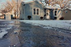
This morning in Saint Cloud, MN the air temperature dropped to minus eight below zero Fahrenheit (-08F°) again as this brutal cold weather continues for the region.
The lack of snow cover also allows the ground frost line to drop much lower than usual this year and is beginning to impact the underground water pipes.
Footage of the aftermath of an underground pipe that burst on the south side of Saint Cloud, MN, spilled over fifty thousand gallons of water through private property and back into the street, where it froze.
City workers needed to use heavy-duty machinery to try and break up the ice almost ten inches deep in some areas.
To help support our freelancers, buy them coffee. https://www.buymeacoffee.com/stormchasing/
To License This Footage For Broadcast, Contact Video @ StormChasingVideo.com
Our Team Merch Store – https://stormchasingvideo.creator-spring.com
See heavy snow on I10 in Northern Florida. Roads blocked, spinouts, stalled traffic due to winter storm dumping historic snowfalls in northern Florida.
Start: 1130pm CDT 1/21
End: 1115am CDT 1/22
#flwx
#weather
#blizzard
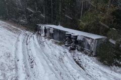
Florida Winter Storm Aftermath Drone Footage from this morning along with drone clips showing the massive amount of snow on the Mobile, AL Civic Center yesterday, 1/21/2025, prior to it collapsing from the weight today.
Shot Description
00:00 (2 Clips) Mobile Civic Center before collapsing with large amounts of heavy snow covering the roof. Footage shot on 1/21/2025 prior to the collapse.
*** Remaining footage was shot around Panama City Beach, FL. ***
00:33 (7 Clips) First Light Panama City Beach Florida covered in snow.
01:27 (2 Clips) Trailer left tipped over after crashing on I-10 near Ponce De Leon, FL.
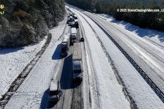
01:43 (4 Clips) I-10 Intersection Closed near Defuniak Springs with vehicles slam packed across the roads at a standstill.
02:24 (2 Clips) Drone Footage of Plows clearing bridge on I-10.
02:52 (3 Clips) Large tow truck pulling on semi with cable winch to free from being stuck.
03:30 Car stuck in the ditch up against a boat trailer as they try to get unstuck.
03:44 Tow Truck driver pulling his winch out to connect to the next tractor trailer.
03:52 (5 Clips) Ground Footage of shots around Panama City Beach and near I-10.
SID: Michael Gordon
#winterstorm #mobileal #mobileciviccenter #crash #automobile
To help support our freelancers, buy them coffee. https://www.buymeacoffee.com/stormchasing/
To License This Footage For Broadcast, Contact Video @ StormChasingVideo.com
Our Team Merch Store – https://stormchasingvideo.creator-spring.com
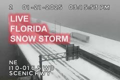
See hazardous winter weather impacting Florida highways live. I10 covered in snow near Pensacola Florida. Part of I10 and area bridges still closed due to snow and ice. January 2025.
#flwx
#weather
#blizzard
A historic Winter Storm Wreaks Havoc on Alabama and Florida Highways and pretty much cripples the area like a frozen hurricane.
Shot Description
00:00 Semi flipped in the ditch of I-10 near Mobile, AL, during a winter storm
00:08 Amazon Prime Truck crashes with brand new Chevy Corvette
00:18 Amazon Prime Truck Jackknifed on snow-covered Interstate 10 in Florida
00:31 Up close shot of plow trucks scraping snow off I-10 near Defuniak Springs, FL
00:43 (4 Clips) Truck stranded on an overpass near downtown Mobile, AL, during winter storm
01:14 Amazon Prime truck crashes with New Chevy Corvette on near Mobile, AL, during Historic Winter Storm
01:25 (3 Clips) Semi Truck rolls over on I-10 near Mobile, AL, sliding into the trees with State Trooper on scene
03:19 Multiple Drone Shots of Panama City Beach, Florida and Pier Park buried in snow from Winter Storm
04:01 USS Alabama Battleship Park Memorial getting blasted by winter storm
To help support our freelancers, buy them coffee. https://www.buymeacoffee.com/stormchasing/
To License This Footage For Broadcast, Contact Video @ StormChasingVideo.com
Our Team Merch Store – https://stormchasingvideo.creator-spring.com
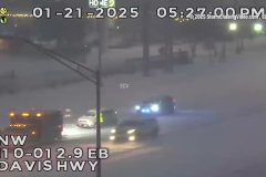
Heavy and blowing snow closes Pensacola Bay Bridge and I10 in Escambia County Florida. Law enforcement blocking bridges and assisting vehicle spinouts on I10 in Florida. Traffic stalled on I10 in heavy snow. FL DOT traffic camera video and Escambia PS radio audio.
Shot Description
00:00 LEOs blocking traffic over Pensacola Bay Bridge as snow blows across roadway.
00:12 LEOs blocking traffic over Pensacola Bay Bridge with palm trees blowing in snow.
00:23 LEOs blocking Pensacola Bay bridge with car stuck in snow on bridge.
00:30 LEOs blocking Pensacola Bay bridge.
00:40 Traffic stalled on I10 in heavy blowing snow.
00:53 Three vehicles in ditch after spinning out in snow in I10.
01:04 Accident in snow on I10.
01:16 First responders arrive to help three vehicles in ditch off I10.
02:03 Semi-truck on snow covered I10.
02:12 LEOs parked in heavy snow on Bay Bridge.
02:15 Heavy snow on I10 and Escambia Bay.
02:35 Heavy snow covers I10.
SID: Brian Dombrowski
Edit Shot Sheet Info
To help support our freelancers, buy them coffee. https://www.buymeacoffee.com/stormchasing/
To License This Footage For Broadcast, Contact Video @ StormChasingVideo.com
Our Team Merch Store – https://stormchasingvideo.creator-spring.com
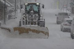
Intense lake-effect snow blanketed the areas east of Lake Ontario. One of the hardest-hit locations was in Copenhagen, NY, where close to 3 feet of snow accumulated, with blizzard-like whiteout conditions making driving nearly impossible.
Shot Description
SHOT 1 & 2: A person shoveling more than 3 feet of snow.
SHOT 3 & 4: Passing shots of houses buried in deep snow.
SHOT 5: Driving by a truck that's stuck in deep snow.
SHOT 6 & 7: A snow plow drives past during heavy snow.
SHOT 8: Driving behind a tractor trailer during intense snow whiteout conditions.
SHOT 9 & 10: A snow plow approaches while scraping snow off the street.
SHOT 11: A person riding a bicycle on a snow-covered sidewalk.
SHOT 12: A snow blower clears snow off a sidewalk.
SHOT 13: Panning shot of a town buried in deep snow.
SHOT 14: A person walking down the street during blinding snow.
SHOT 15: A person using a snowblower during heavy snow.
SID: David Lewison
#winter #lakeeffectsnow #witnerstorm #weather #NYWX
To help support our freelancers, buy them coffee. https://www.buymeacoffee.com/stormchasing/
To License This Footage For Broadcast, Contact Video @ StormChasingVideo.com
Our Team Merch Store – https://stormchasingvideo.creator-spring.com
See hazardous winter weather impacting Florida highways live. I10 covered in snow near Pensacola Florida. January 2025.
#flwx
#weather
#blizzard
Last morning folks in northwestern Wisconsin will have to deal with the brutally cold air as the Arctic blast continues. Wind-chills early this morning ranged from near 40 below zero to 35 below zero.
Shot Description
Clip 1. Medium shot of a sign reading 25 below zero.
Clip 2. A close up shot of the same sign reading a very cold temperature of 25 below zero.
Clip 3. A wide shot of steam rising by the Rice Lake dam.
Clip 4. A close up shot of steam rising by the Rice Lake dam.
Clip 5. Pancake ice starting to form at the Rice Lake dam.
Clip 6. Close up shot of the pancake ice.
Clip 7. A wide shot of the steam rising off the water.
Clip 8. A medium shot of the steam rising off the water.
Clip 9. Close up shot of the steam.
Clips 10-11. Steam rising from two different factories in Rice Lake.
Clip 12. Steam rising from a partial snow covered storm drain.
Clip 13. Exhaust from a vehicle's tailpipe.
Clip 14. A flag blowing in the wind.
Clip 15. A couple of flags are blowing in the wind. (Hand held shot)
SID: Dirk Miller
#polarvortex #extremecold #subzero #weather
To help support our freelancers, buy them coffee. https://www.buymeacoffee.com/stormchasing/
To License This Footage For Broadcast, Contact Video @ StormChasingVideo.com
Our Team Merch Store – https://stormchasingvideo.creator-spring.com
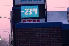
An Arctic blast is well underway across the area. This morning temps drop down to 23 below zero in Rice Lake, WI. Wind-chills were running 35 to 33 below zero. The brutally cold air was causing problems with car not starting. Area schools also closed down for the day, and many of them are closing for tomorrow as well.
Shot Description
Clip 1. A bank thermometer flashing 23 below zero.
Clips 2-4. People are trying to start a vehicle in the harsh winter conditions.
Clip 5. Shows traffic on the main street in Rice Lake and also shows the exhaust from the vehicles & tailpipes.
Clip 6. A wide shot of steam rising from the river by the Rice Lake dam.
Clip 7. A closer shot of the steam rising from the river. Traffic also driving through the shot.
Clips 8-12. Various chimney pipes with steam and heat rising off of them.
Clip 13. A very cold-looking half moon, ready to call it a night.
SID: Dirk Miller
#wiwx #weather
To help support our freelancers, buy them coffee. https://www.buymeacoffee.com/stormchasing/
To License This Footage For Broadcast, Contact Video @ StormChasingVideo.com
Our Team Merch Store – https://stormchasingvideo.creator-spring.com
Brutally cold weather is moving back into the Midsection of the nation today, with the morning low temperatures in the negative teens. Local area schools kept kids inside for recess, and virtually nobody was walking around the streets due to the extreme cold wind chills. As of Noon, the air temperature was zero, and the Wind Chill was -13°F in Saint Cloud, MN.
Shot Description
00:00 – Digital sign with the air temp displaying -15F.
08:00 – Digital sign with the date at sunrise displaying -11F.
00:18 – Digital sign at Saint Cloud Tech College showing it was -13F.
00:30 – Someone walking in downtown Saint Cloud while covering their face from the brutal cold air.
00:43 – Drone video over Lake George with the city skyline behind it as crews removed snow from the lake to make an ice rink for skaters.
00:53 – Drone following a large snow blower on Lake George that was being used to remove the snow to make a large skating rink.
01:05 – Two clips of the equipment clearing the snow from the lake.
01:38 – Traffic on Highway 23.
To help support our freelancers, buy them coffee. https://www.buymeacoffee.com/stormchasing/
To License This Footage For Broadcast, Contact Video @ StormChasingVideo.com
Our Team Merch Store – https://stormchasingvideo.creator-spring.com