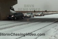
After dark footage of the snowstorm that dumped epic snow rates across the front range around Denver, CO. Snow totals in Denver are adding up quickly as 2-3″ snowfall rates piles on the snow.
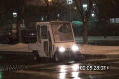
Video package shot in north Denver after dark during the snowstorm where half a foot of snow had fallen in 5 hours time on the north side. This video was shot along Federal and 120th Avenue of traffic and snow plows driving across snow covered roads.
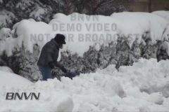
Video ends as the snowstorm has cleared the Denver area and cleanup can begin. Video package includes various scenes of people shoveling snow, snow blowing, and bull-dozing.
Storm Chaser Tony Laubach sent in one very cool video package in tonight that actually shows how Denver, CO has gone from Summer back to Winter as the city had hail this afternoon and now has heavy snow falling this evening. A very strong storm system promising big snows in Denver over the next 24 hours lead in with thunderstorms across the metro area. A thunderstorm with graupel (very fine, small hail) moves over downtown Denver mid-afternoon on Tuesday accompanied by some claps of thunder. This storm is a sign of good instability with this system and should dump 8-16″ of snow across Denver by this time tomorrow.
Video package includes shots during the height of the thunderstorm with bee-bee sized graupel falling along Speer Blvd. in Denver. Several clips contain audio track of thunder with various traffic shots during the storm. A shot of my arm with the graupel falling on a black sleeve shows the ice close up.
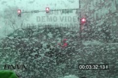
Then the Snow begins during the evening commute with extremely heavy snow falling with a snowy clip looking at the state capital building. Various other shots of traffic driving through heavy snow as well as people around downtown walking through the very heavy snow.
Ends with shots of people clearing snow from their cars.
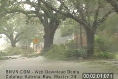
Storm Chaser Tony Laubach was out covering the major winter storm system in Denver, CO this week as the temps dropped from the mid 70s with sunny skies to below freezing and a winter storm.
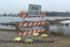
The Wild Rice River is flooding it’s banks and creating major flooding that is impacting Richland County, ND which is just south of the Fargo area near the town of Abercrombie, ND.
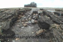
Most of the rural roads within a mile of the river are being washed away as the flooding backs up into farmers fields and then spills over the roadways to create a new path for the water to flow.
The last clip is four minutes of video that is compressed into ten seconds of time lapse footage.
Major flooding is setting up in the Red River Valley to the southeast of the Fargo / Moorhead area as above normal temps rapidly melt off the winter snow pack.
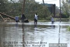
Footage shows the major flooding impacting the Sabin, MN area along the Buffalo River which has burst it’s banks by a half mile in places.
The area was covered with fog and lite rain as the flood waters covered the landscape.
TRT: 6:05 – HD Footage
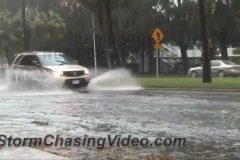
Heavy rain floods roads and hinders travel in Sarasota, FL this afternoon as severe storms impact southern Florida. Foootage also includes the now famous “Google Island” sign as the area competes for the Google Fiber contest http://www.googleisland.net/
Severe storms move across northern Oklahoma and dump 1-inch diameter hail. Traffic on I-35 was slowed down considerably in and around Perry due to the hail accumulating several inches deep.
HD video package opens with POV driving shots as hail starts to fall. Also includes passing a vehicle that spun out into the median. Various other shots of traffic driving through the deep hail. Also includes people under an overpass clearing their cars of the quarter sized hail as well as other post-storm shots.
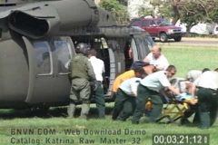
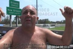
Part F – 08/30/2005 Footage shot at Interstate 10 and Causeway Overpass of Coast Guard and National Guard helicopters landing and dropping off people who were rescued from their roof tops in New Orleans. Footage shows the massive rescue effort that was happening as survivors were waiting for additional busses to transport them to shelters outside of the devastated area. Footage ends with an interview of a man that asked for a ride from the photographer to try and get to his mothers home to take shelter in the city of Kenner, LA. The interview explains what happened to him which is pretty much the same story for most of the survivors of Hurricane Katrina in the New Orleans, LA area. Catalog ends with non flooding storm damage along Airline Highway.
Part E – 08/30/2005 Footage shot at Interstate 10 and Causeway Overpass of Coast Guard and National Guard helicopters landing and dropping off people who were rescued from their roof tops in New Orleans. Footage shows the massive rescue effort that was happening as survivors were waiting for additional busses to transport them to shelters outside of the devastated area. Footage ends with an interview of a man that asked for a ride from the photographer to try and get to his mothers home to take shelter in the city of Kenner, LA. The interview explains what happened to him which is pretty much the same story for most of the survivors of Hurricane Katrina in the New Orleans, LA area. Catalog ends with non flooding storm damage along Airline Highway.
Part D – 08/30/2005 B-Roll Footage shot at Interstate 10 and 610 interchange which became a boat ramp rescue launching point for those needing to be rescued from the massive flooding that devastated the New Orleans, LA metro area. Video shots include FEMA rescue workers bringing people by boat to the staging area. Footage of the New Orleans skyline overlooking Interstate 10 which was not covered by several feet of flood water and close up shots of a pumping station surrounded by flood waters. Additional B-Roll clips showing FEMA personnel setting up rescue operations and some of the first buses to come and take people out of the area. Catalog includes an interview with a woman that was rescued and a man that brought his boat to come and help out the rescue efforts.
Part C – 08/30/2005 B-Roll Footage shot at Interstate 10 and 610 interchange which became a boat ramp rescue launching point for those needing to be rescued from the massive flooding that devastated the New Orleans, LA metro area. Video shots include FEMA rescue workers bringing people by boat to the staging area. Footage of the New Orleans skyline overlooking Interstate 10 which was not covered by several feet of flood water and close up shots of a pumping station surrounded by flood waters. Additional B-Roll clips showing FEMA personnel setting up rescue operations and some of the first buses to come and take people out of the area. Catalog includes an interview with a woman that was rescued and a man that brought his boat to come and help out the rescue efforts.
Part B – 08/30/2005 B-Roll footage of people who were just rescued with their pets from the flooding around New Orleans and interviews with people telling their story about how they were rescued. Also includes shot of additional EMS personnel setting up, aerial shots from a bridge of cars underwater and air bubbling up to the surface. Additional B-Roll video includes the Pontchartrain Expressway pumping station surrounded by water with the New Orleans, LA skyline in the distance with a flooded out Interstate 10 in the foreground. Also footage of rescue boats bringing survivors to the staging area before being bussed out of the area.
Part A – 08/30/2005 B-Roll footage of people who were just rescued with their pets from the flooding around New Orleans and interviews with people telling their story about how they were rescued. Also includes shot of additional EMS personnel setting up, aerial shots from a bridge of cars underwater and air bubbling up to the surface. Additional B-Roll video includes the Pontchartrain Expressway pumping station surrounded by water with the New Orleans, LA skyline in the distance with a flooded out Interstate 10 in the foreground. Also footage of rescue boats bringing survivors to the staging area before being bussed out of the area.
Part B – 08/30/2005 B-Roll footage from Williams Blvd. and Veterans Blvd in Kenner, LA of people walking through the flooded roadway to try and get to the airport to be evacuated while others are checking out the damage and flooding. Video catalog then continues at the Orleans Parish line overlooking the 17th Street Canal and Pontchartrain Expressway pumping station pipes. This is where the massive interstate 10 and 610 rescue effort was being setup. B-Roll video of rescue crews from as far away as Kentucky and Missouri along with the National Guard and FEMA were organizing the massive overwhelming tasking of trying to search and rescue people from the flooded out metro area.
Part A – 08/30/2005 B-Roll footage from Williams Blvd. and Veterans Blvd in Kenner, LA of people walking through the flooded roadway to try and get to the airport to be evacuated while others are checking out the damage and flooding. Video catalog then continues at the Orleans Parish line overlooking the 17th Street Canal and Pontchartrain Expressway pumping station pipes. This is where the massive interstate 10 and 610 rescue effort was being setup. B-Roll video of rescue crews from as far away as Kentucky and Missouri along with the National Guard and FEMA were organizing the massive overwhelming tasking of trying to search and rescue people from the flooded out metro area.
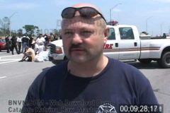
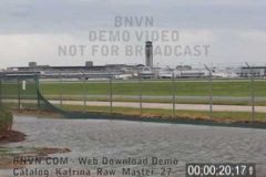
Part B – 08/29/2005 B-Roll aftermath footage shot around the New Orleans, LA International Airport that shows the huge difference in the damage depending on the location around the metro area. On the south side of the airport along Airline Highway, there is no flooding, only damage from the high winds. While the south side of the airport was high and dry, the north side of the airport at Williams Blvd. and Veterans Blvd. was flooded with several feet of water and the water was still rising. Footage includes cars floating in the high water and people walking in the high water while large police truck drive through the flooded roadways.
Part A – 08/29/2005 B-Roll aftermath footage shot around the New Orleans, LA International Airport that shows the huge difference in the damage depending on the location around the metro area. On the south side of the airport along Airline Highway, there is no flooding, only damage from the high winds. While the south side of the airport was high and dry, the north side of the airport at Williams Blvd. and Veterans Blvd. was flooded with several feet of water and the water was still rising. Footage includes cars floating in the high water and people walking in the high water while large police truck drive through the flooded roadways.
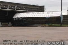
Part B – 08/29/2005 B-Roll footage of the aftermath from Kenner, LA that was shot around the New Orleans, LA International Airport and shows the damage to the security fence, main terminal and vehicles in the parking ramp and hangers. Footage also shot inside the airport of people taking shelter who were waiting to be evacuated. Clips of people sleeping on the floor and an interview with a family from France that was stranded at the airport while trying to evacuate.
Part A – 08/29/2005 B-Roll footage of the aftermath from Kenner, LA that was shot around the New Orleans, LA International Airport and shows the damage to the security fence, main terminal and vehicles in the parking ramp and hangers. Footage also shot inside the airport of people taking shelter who were waiting to be evacuated. Clips of people sleeping on the floor and an interview with a family from France that was stranded at the airport while trying to evacuate.
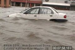
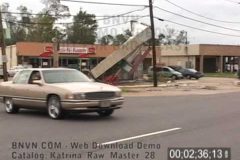
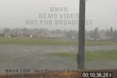
08/29/2005 Raw B-Roll footage shot at Interstate 10 and Williams Blvd just north of the New Orleans, LA International Airport that shows the massive flooding from Hurricane Katrina’s heavy rains. The water is several feet deep in places and cut off access to the airport via Williams Blvd. Catalog ends with footage of a home destroyed by Katrina’s high winds in Kenner, LA.
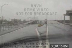
Part B – 08/29/2005 Raw B-Roll POV footage through Metairie, LA through the flooding and debris on Veterans, Blvd. to Causeway Expressway that shows the several feet of water in areas on the road as the flooding was just beginning. Footage of flying debris slamming into the front of the SUV while entering Interstate 10 and followed with video of debris covering Interstate 10 and ended with overview of the New Orleans International airport field being flooded by the heavy rains and damaged by the high winds.
Part A – 08/29/2005 Raw B-Roll POV footage through Metairie, LA through the flooding and debris on Veterans, Blvd. to Causeway Expressway that shows the several feet of water in areas on the road as the flooding was just beginning. Footage of flying debris slamming into the front of the SUV while entering Interstate 10 and followed with video of debris covering Interstate 10 and ended with overview of the New Orleans International airport field being flooded by the heavy rains and damaged by the high winds.
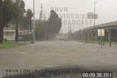
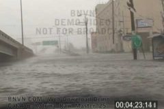
Part B – 08/29/2005 Raw B-Roll POV footage shot during the escape from New Orleans, LA as the cameraman drives through the city of Metairie, LA and dodges debris and downed trees, power lines and flying shrapnel. Footage shot POV thought most of Metairie, LA to Bonnabel Blvd. entrance on Interstate 10. This entrance was also blocked by debris and flood waters. After finding the freeway entrance was blocked, the footage continues on back streets to Veterans Blvd and Helios Avenue.
Part A – 08/29/2005 Raw B-Roll POV footage shot during the escape from New Orleans, LA as the cameraman drives through the city of Metairie, LA and dodges debris and downed trees, power lines and flying shrapnel. Footage shot POV thought most of Metairie, LA to Bonnabel Blvd. entrance on Interstate 10. This entrance was also blocked by debris and flood waters. After finding the freeway entrance was blocked, the footage continues on back streets to Veterans Blvd and Helios Avenue.