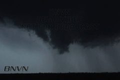
Description: Severe and tornadic storms move across northern Kansas and southern Nebraska. Storms produce hail, very high winds, and a few isolated tornado reports.
Video package opens up with raw video from Fairbury, Nebraska where a tornadic storm passes directly over the town. Reports of a tornado were received from this storm just east of town. Video clip is POV shot going into town when RFD winds wrap into the town and knock out power. From intersection, you can see traffic lights go out and power lines wildly swinging in the wind (top right). Following shot of lowering from the same storm a few minutes later once precip was cleared. Winds were estimated to be over 60mph in town.
Last half of video is from Washington County, Kansas of severe storms moved through the area. Opens up with a lightning strike from POV, then quick shots of wind blowing leaves and small branches onto videographer. Next shot of a close-up shelf cloud. Next shot of a wall cloud over northern Washington County, KS. Last shot from moving car of a wide pan of the shelf cloud structure.
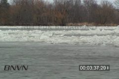
03/19/2010 Mississippi River Ice Jam With an early spring thaw, the ice along the Mississippi River in Central Minnesota near the city of Saint Cloud started to pile up and caused an Ice Jam.
Footage of ice moving along the river and Time-Lapse footage showing the grinding of the ice.
Time-Lapse footage of the ice jam moving along the Mississippi River.
The footage is 12;48;00 that is sped up 600% to cover only 2;08 of time to show the grinding motion of the ice as it flows on the river.
Catalog # 03192010A_HD
Total Run Time: 09;12;11
Format: HD
Severe storms move through western Nebraska bringing high winds and hail. This video package includes video shot along US-30 near Chappell, Nebraska. Video opens with a couple of scenes of blowing dust in fields just south of the highway thanks to the high winds on the leading edge. Shots after include hail up to 1-inch in diameter covering the highway and pelting the ground.
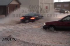
The second part of the video was shot around Ogallala, NE as a line of storms plows through western Nebraska with high winds, hail, and heavy rain. Package opens up with storm clouds on the leading edge of the line. Various shots following include vehicles driving through high water on the main road of Ogallala, Nebraska. First couple of flood shots include vehicles driving at the camera with water going over the headlights. Various other shots of vehicles driving through the flooding as rain continues to fall.
Lightning during the early morning hours this morning lit up the sky near the city of Litchfield, MN. The lightning was pretty intense and as it filled the sky.
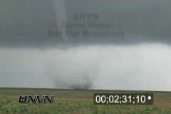
4/10/2005 Trego County Kansas Tornado Video. Footage of a tornado over open country. First clip shot while being hit with hail and the second and third video clips of the tornado over open farm country.
Catalog #: 04102005b_dc
Total Run Time: 6:40
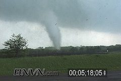
4/10/2005 Trego County Kansas Tornado Video. A large tornado rolls over open country. First half of the video from the main tripoded camera. Second half of the video is from the dash mounted video camera.
Catalog # 04102005a
Total Run Time: 9:04
To license this footage, contact http://www.StormChasingVideo.com
5/4/2003 Kansas Turnpike Tornado Video. Tornado hits the Kansas Turnpike just west of Kansas City in Wyandotte County Kansas. The Tornado comes within 50 yards of the cameraman as the debris falls from the sky on top of him. The video starts out slow because the tornado is coming straight for the camera. Once the tornado passes by the camera, it keeps heading east towards the Kansas City metro area.
Catalog ID: 05042003A
Total Run Time: 08:45;00
To license this footage, contact http://www.stormchasingvideo.com
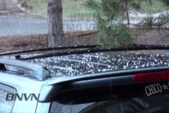
A quick change from the record heat Denver had experienced earlier in the week. After breaking a 130 year old record with an 82 degree high on Monday, Denver drops into the 40s with convective storms popping up.
Video package includes footage of graupel and snow pellets coming down with one of the area’s convective storms. It wasn’t quite snow as the temperature was in the mid 40s at the time of this storm, so it was almost a hailstorm. Various shots of heavy snow pellets/graupel hitting the ground and nearby cars.