The fire continues at the Round Mountain fire southwest of Loveland, CO.
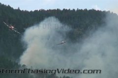
Video shows a slurry bomber dropping retardant and fire shoots up on trees while a test plane checks path for slurry bombers.
Severe storms packed high winds that looked more like a tropical storm then a thunderstorm over Southwest Minnesota near the City of Marshall, MN which is in Lyon County.
BNVN Weather Paparazzi Justin King was covering the wild fires in Glen Haven and Drake Colorado yesterday and sent in this video package.
The first wild fire video was from Glen Haven, Colorado. The video opens with shot of a high fire danger sign, then goes to the North Fork Trail head parking lot for a good look at the initial smoke from the fire when it was 15-35 acres in size. Next shots are all taken from North of Estes Park in a residential area close to Rocky Mountain National Park. Video has smoke shooting up into the sky and looking like Cumulonimbus clouds. Air tankers and other small aircraft were in the area but they did not drop slurry at time of filming. Helicopter support trailer, the US Forest Service, and Rocky Mountain National Park rangers arrive on scene later in the video. At the very end we were ushered out of the area as they were closing it down for staging equipment. At time of leaving the fire it was estimated to be over 100 Acres in size and growing fast.
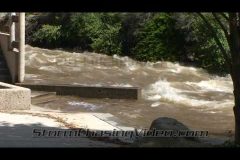
The second fire of day was in Drake, Colorado. The video opens near incident command post on Highway 34 near the Round Mountain Trail head, video shows flames shooting up from the trees, quick shot of command, and back to the fire. Later moved west to get a better vantage point and was behind the flames looking uphill. Video shows trees going up like match sticks, glow from behind the flames looking up, and some fire apparatus heading to staging area for structure protection, there are homes threatened by this fire.
To license this footage, contact http://www.stormchasingvideo.com
Video opens with shot of a high fire danger sign, then goes to the North Fork Trail head parking lot for a good look at the initial smoke from the fire when it was 15-35 acres in size. Next shots are all taken from North of Estes Park in a residential area close to Rocky Mountain National Park. Video has smoke shooting up into the sky and looking like Cumulonimbus clouds. Air tankers and other small aircraft were in the area but they did not drop slurry at time of filming. Helicopter support trailer, the US Forest Service, and Rocky Mountain National Park rangers arrive on scene later in the video. At the very end we were ushered out of the area as they were closing it down for staging equipment. At time of leaving the fire it was estimated to be over 100 Acres in size and growing fast.
Drake, Colorado
2nd fire of day: video opens near incident command post on Highway 34 near the Round Mountain Trail head, video shows flames shooting up from the trees, quick shot of command, and back to the fire. Later moved west to get a better vantage point and was behind the flames looking uphill. Video shows trees going up like match sticks, glow from behind the flames looking up, and some fire apparatus heading to staging area for structure protection, there are homes threatened by this fire.
Severe storms hit the Minnesota area tonight with extreme high winds and large hail around the Clear Lake MN area, which is just north of the Twin Cities metro area on interstate 94.
From the looks of the damage, extreme high speed straight line winds hit the area since all of the damge over a wide area was all blown to the southeast.
This footage includes high winds and hail along with power lines shorting out as a tree branch falls on live power lines. The aftermath footage shows a lot of trees down including trees down on homes in the Clear Lake, MN area.
To license this footage, contact http://www.bnvn.com
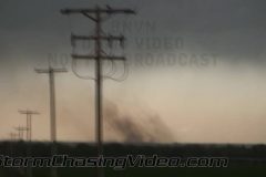
BNVN Weather Paparazzi Justin King was chasing around Log Lane Village, CO & Akron, CO where he shot a small funnel protruding from storm where it had a non-condensed ground contact was made and the extremely high wind was pushing out a nice dust trail from the contact point.
The storm progressed east where more ground circulation was noticed. Winds in excess of 50 mph during storm. At 50 second mark there is a second touchdown that wasn’t even noticed until looking at video (short clip). next scenes are storm motion, storm structure, road cones blown over from the high wind (very ruff road), and more storm structure from north of Akron, CO and a nice updraft core condensing at the end.
To license this footage, contact http://www.bnvn.com
BNVN Weather Paparazzi Tony Laubach was on the severe storms that fired in Colorado after days of a stout cap preventing storm development. This storm was a long-track supercell that formed over Boulder, Colorado in the foothills and moved into Kansas several hours later. Storm dropped hail and a few brief tornadoes across northern Colorado.
Video package opens up with POV driving shots as slushy hail falls and splats on the windshield. Next couple scenes include falling rain and hail. Last shot of POV is with a rainbow, lots of hail covering the road, and falling rain.
Next series of shots include hail up to 1-inch in diameter falling east of Akron. Stones can be seen bouncing out of the grass and off nearby dirt roads. Several shots of hailstones splashing into puddles as well.
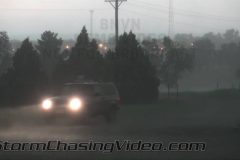
Video then focuses on street flooding in Akron along US-34, the main drag in town. Water was 6-12 inches deep in spots. Video shows various shots of vehicles driving through high water, including cars, pick up trucks, and semi trucks.
To license this footage, contact http://www.bnvn.com
June 17, 2010 Pine County, MN which is south of the city of Duluth, MN, a violent tornado hit the area just east of Pine City, MN along the Minnesota and Wisconsin boarder. The tornado injured several people and destroyed one home and damaged another along Highway 70.
The damage footage was shot after I stopped and called in the destroyed home to authorities and made sure the scene was stable until EMS showed up.
BNVN Weather Paparazzi Tony Laubach was on a tornadic storm that developed near I-25 and moved over the town of Chugwater, Wyoming, about 45 miles north of Cheyenne on Sunday. The video package opens up with tripoded dash footage of massive high-contrast wall cloud rotating over I-25 just south of the Chugwater exit. Next shot of a brief funnel and cloud swirls directly overhead
Next shots in storm as 60mph winds and golf ball hail fall. Various POV shots of hail falling on the street. Last storm shot shows baseball size hail on the roads as golf balls fall and impact dark pavement.
Next shot includes two baseball hailstones in hand against a destroyed windshield with people inside the car wiping glass from the dash. Various other shots include hailstones stacked up against a baseball and tennis ball. Other shots of very spiky hail in chaser’s hands. One scene of a hailstone stacked up against a dollar bill.
Next series of shots are low-ground shots of hail covering roads just east of Chugwater. Middle shot of an SUV slowly driving away.
Last shot a humor shot of a very close lightning strike just off camera and the immediate thunder. Lightning hit the field less than 30 feet from vehicle and sent a larger plume of smoke into the air. Scene just includes bright flash, thunder, and chaser audio as camera was pointed straight ahead.
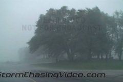
High winds from severe storm hit Kalamazoo, MI on Friday evening.
Footage includes shots of the storm moving into the area and continues as the heavy rains and high winds impact the drives.
Some tree damage was reported from the storms.
To license this footage, contact http://www.bnvn.com
June 17, 2010 – Eric Whitehill was in Wadena, MN as the tornado hit the town. Eric gets video of the tornado coming into down with debris up in the air. After the town gets hit, Eric checks out the damage path around Wadena, MN.
June 17, 2010 – Severe storms and powerful tornadoes rake western Minnesota on Thursday. Video package includes tornado video shot by TWISTEX researcher, Ed Grubb and continues with damage footage shot by TWISTEX researcher Tony Laubach.
Opening shot of one of the tornadoes in the Wadena area as chasers drive north toward town. Following shots are POV shots immediately after the tornadoes as they navigate damaged areas on the southwest side of town.
Next shots of a group of girls hugging after the storms moved out. One girl is crying.
Next series of shots from the Wadena/Deer Creek High School that took a direct hit from the tornado. Various shots of damage on the school grounds including several overturned cars that were in the parking lot, including one of a golden sedan that was pulverized.
Next series of shots includes damage video from a nearby neighborhood. This section opens with two cops blocking the road with a severely damaged house in the background. Various other shots of damaged homes and vehicles as well as shots of various crews and people wondering around.
SID: Tony Laubach
June 17, 2010 – Brandon Sullivan shot this amazing tornado footage near the town of Bricelyn, MN which is about twenty miles west of Albert Lea, MN on Interstate 90.
The dramatic footage shows a cone tornado that morphs into a multi-vortex tornado and then into a wedge tornado and back to a cone and large tornado for almost an hour.
The Elkhorn river is a t flood stage just North West of the Omaha metro on in the town of Waterloo, Nebraska. The river is expected to continue to rise tonight into tomorrow and cause flooding to the homes and buildings.
The BNVN Weather Paparazzi crews caught a strong rain wrapped tornado that touched down 7 miles south/southwest of Elmwood, Oklahoma in Beaver County.
In the footage shot by TWISTEX team members Tony Laubach, the video opens up with developing funnel cloud before going to the tornado first touching down. Couple of scenes of tornado at its mature stage as it becomes a very large cone and crosses the county road. Video ends with driving shot of tornado to chaser’s north. There are reports that a farm was damaged in this tornado.
To license this footage for broadcast, contact http://www.bnvn.com
Tony Laubach and the Twistex Research crew were storm chasing in the Texas Panhandle on Saturday as large hail hammers the area. In the video package that Tony shot, it opens up with large hail bouncing on the roads and in the grass and fields. A couple shots of an emergency vehicle in the hail. Next shots of extremely large hail (4+ inches) being picked up and measured including one shot of 4.0″ hailstone with a ruler. Ending shots with large hailstones with a baseball and tennis ball.
To license this footage, contact BNVN at http://www.bnvn.com
Severe storms produce strong winds and weak tornadoes across eastern Colorado. The TWISTEX research team intercepted several weak tornadoes east of Limon, Colorado Friday evening.
Video package opens up with several cloud/structure shots before transitioning to two weak tornadoes. The first touching down north of Arriba, CO with a white cone funnel and debris swirl. Second tornado produced a dust whirl beneath funnel to which handheld and dash-cam shots are used. Last shot a wide of the storm and rain shaft.
To license this footage for broadcast, contact http://www.bnvn.com
The newest member of the BNVN Weather Paparazzi crew, Eric Treece, caught two picturesque tornadoes near Last Chance, CO. The tornadoes moved over open country with perfect photographic lighting to back-lite the tornado that was on the ground for several minutes.
To license this footage, contact http://www.bnvn.com
Tony Laubach was out chasing yesterday in Scottsbluff, NE where he was in the middle of a severe storm that dumped a lot of rain and hail on the area. The video opens with several shots of heavy rain and hail falling on the west side of Scottsbluff. Video transitions to some road ponding in northern Scottsbluff where a neighborhood road turned into a small running creek. Shot opens with kids playing in the water on the road. Various shots after include vehicles driving through the streaming water, including a storm chasing mesonet vehicle. Various generic shots of water running down the road end this segment.
At about 11pm, another severe storm rolled through Scottsbluff with 1.25″ hail. Various shots from the Candlelight Inn hotel of hail falling on vehicles and in the parking lot. One scene where camera man gets startled by close lightning strike. Various shots of hail falling on the pavement and on cars.
To license this footage, contace http://www.bnvn.com
The flooding continues in Greeley, CO as the Cache La Poudre River at 71st avenue south of “O” Street.
In the video by BNVN Weather Paparazzi Justin King, the water is running across the road very rapidly and is surrounding some outbuildings. The homeowner at this location stated they have water in their office room. Video goes onto the bike path nearby where 4+ inches of water are running across and down the trail. Open space to the east and west of the road is flooded approximately 3 feet deep in places. Final scene is at 83rd ave where only a few inches are gently crossing the road.
The National Weather Service in Denver, CO has a flood warning for the area until 9:45 p.m. Thursday.
To license this footage, contact http://www.bnvn.com
Our Bahamas stringer, TI, was able to get footage of 17-year-old Madison Pugh being brought into jail after being extradited to stand trial for the murder of her mother.
Pugh was extradited from Pennsylvania to the Bahamas last week. Pugh and her boyfriend Zyndall McKinney, 23, are charged for the murder of Anna Garrison, whose body was found wrapped in plastic and dumped on the side of the road last year.
In the footage, it shows Zyndall McKinney and Madison Pugh being brought separately into a court hearing in hand cuffs.
To license this footage, contact http://www.bnvn.com
The National Weather Service in Denver, CO has issued a flood warning for west central Weld County in northeast Colorado which includes parts of Windsor, CO and Greeley, CO until 3:45 a.m. mountain daylight time.
Our own BNVN weather Paparazzi Justin King, was out documenting the flooding in Windsor, CO today along county road 19 as the Cache La Poudre River was overflowing it’s banks. The footage he shot shows the water over several roads and fields west of Greeley and south of Windsor, CO.
On Monday Evening BNVN Weather Paparazzi Tony Laubach was chasing tornadic storms that pummeled parts of the Nebraska panhandle. The storms brought several weak tornadoes, very strong winds, gigantic hail, and very heavy rains.
In the video package that Tony shot, it opens up with various sky shots of turbulent, rotating clouds over the north side of Scottsbluff, Nebraska. The video transitions to during storm with very large hail falling and very strong winds blowing hailstones and leaves around while drivers were seeking shelter under a church overhang. The next few clips show Three (3″) inch and larger hailstones against a ruler to show the size of the hail that was falling in the area. The video ends with footage of minor road flooding in Scottsbluff, NE along with a several grain silos that were blown across some railroad tracks along US-26 east of Scottsbluff, NE.
To license this footage, contact http://www.bnvn.com
Several rounds of severe storms pummel northeast Colorado. Video package includes severe weather scenes from Morgan County just west of Fort Morgan. Opening scenes of supercell from a distance as chasers approach. Next scenes of cloud decks under the storm’s updraft. Video transitions to hail and high winds as storm unloads along I-76 west of Fort Morgan. The storm dumped 1.50″ hail as measured in one-scene where a hailstone is put against a half-dollar coin. Last scene of a bus that overturned during the storm, sliding from the eastbound lanes across the westbound lanes before rolling to a stop off the west median. 1 injury was reported in the crash.
The Big Thompson River that runs through Estes Park, CO which is about twenty miles west of Loveland, CO and fifty miles northwest of Denver, CO is at flood stage this weekend. The public works department was trying to secure the historic water wheel on the west end of down town which was slamming around due to the very high water in the Big Thompson River. Flood waters is starting to go over the river banks and flood parking lots and walk ways.
The flooding is due to the rapid snow melt in the nearby mountains as warmer summer weather moves into the area.