While the heavy snow hit Minnesota, BNVN Weather Paparazzi Shannon Lupton was out covering the winter storms in Madison, WI on Sunday that coated the area with ice due to the freezing rain.
Snow plows were busy trying to clear away the slush on the roads before it froze solid but it wasn’t soon enough for some drivers who ended up in the ditch or stuck in backed up traffic on Interstate 94.
After the sun went down, the temperature’s dropped, the freezing rain became thicker and coated street signs. Tree’s and automobiles were also coated with at least a quarter inch of ice.
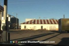
This is a time lapse video of my drive to the 2011 National Storm Chasers Convention in Denver, CO. I started the drive from my home in Saint Cloud, MN with the camera setup to do a timelapse of the whole drive.
The route I took was down MN Highway 15 to MN Highway 60 to the Iowa boarder. Then I drove on 60 to Iowa Highway 75 to Sioux City. I crossed over into Nebraska and took highway 77 south to Fremont, NE where I turned onto Highway 30 and drove to Columbus, NE. From there I took Nebraska 81 to Grand Island, NE and dropped to Intersate 80 and followed that west into Colorado when it turned Interstate 76 and then drove into Denver, CO. Once in Denver I took 76 to east bound 70 and exited on Quebec Street.
Enjoy, Doug
http://www.WeatherPaparazzi.com
In Northwest Arkansas they received four years worth of snow with this latest winter storm today. Storm reports from the National Weather Service show at least twenty inches of snow in Washington County.
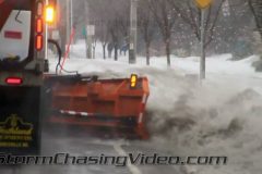
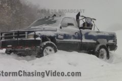
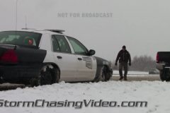
BNVN Weather Paparazzi Brandon Sullivan was out in the winter storm today along Highway 412 in Far Eastern OK to Springdale, AR where he documented the extreme weather travel hazards.
The roads are next to impassable with the deep snow in the deep south as dozens of drivers were spinning out and getting stuck and becoming stranded. At one point Brandon even documented a Arkansas Department of Transportation Snow Plow being pulled out of a ditch after becoming stuck in the snow.
To license this footage, contact http://www.StormChasingVideo.com
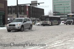
Today BNVN Weather Paparazzi Tony Laubach was out in the snow in Denver, CO which is getting the latest in a series of small snowstorms that finally is starting to bump up the snow totals in a parched Denver, Colorado.
Over the last couple days, nearly half a foot of snow has been recorded nearly doubling the season’s totals. A fun fact, Denver has seen more snow in the January and February than it has all season. Less than 5 inches from September, October, November, and December and over a foot in what’s typically two of the driest months for snow (5th and 6th).
September (8th): 0.0″ (averages 2.1″)
October (7th): 0.0″ (averages 4.1″)
November (2nd): 1.5″ (averages 10.7″)
December (4th): 3.3″ (averages 8.7″)
January (5th): 8.0″ (averages 7.7″)
February (6th) (as of Feb 7): 4.2″ (averages 6.3″)
March (1st): N/A (averages 11.7″)
April (3rd): N/A (averages 9.1″)
TOTAL SEASON SNOW AS OF FEB 7: 17.00″
TOTAL SNOW SEPT-DEC: 4.8″
TOTAL SNOW JAN-FEB 7: 12.2″
SNOW TOTAL AVERAGE SEPT 1-JAN 31: 33.3″
Information from Denver/Boulder National Weather Service.
Video of snow-packed roads along major routes across Denver. Opens up with POV shot at I-25 southbound where I-70 merges. Other shots along US-287 in Westminster and Broadway Blvd in Denver. Shots of vehicles driving on snow packed roads.
To license this footage, contact http://www.stormchasingvideo.com
The winter weather in the south just keeps on hitting the area this week with another winter storm warning for parts of Oklahoma and Texas. Today BNVN Weather Paparazzi Brandon Sullivan was documenting the winter storm just to the east of Oklahoma City on Interstate 40.
The unexpected burst of snow caught drivers off guard as heavy snow fell on the interstate causing white out conditions. Several car crashes were reported by the Oklahoma Highway Patrol.
To license this footage, contact http://www.stormchasingvideo.com
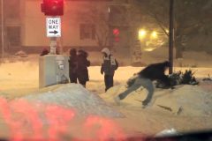
BNVN Weather Paparazzi, Shannon Lupton shot the final video package to round out our epic blizzard coverage today. The video is from the Madison, WI area where heavy snow and white out conditions were around all day long.
To license this footage contact http://www.stormchasingvideo.com
BNVN Weather Paparazzi Scott Weberpal was covering this major epic blizzard system along the Lake Michigan shoreline near Racine, WI at the Wind Point Lighthouse.
The video Scott produced is pretty simple to explain, BIG WAVES. The winds on the north side of the epic winter storm system that has shut down a good part of the United States was creating some major waves which crashed into the shoreline. With the air temp almost stable along the lake front at about 20F all day long, the water turned to ice almost as soon as it crashed onto the rocks along the shoreline.
Winds along Lake Michigan in the Milwaukee and Racine Wisconsin area are gusting over 40 MPH currently.
To license this footage, contact http://www.stormchasingvideo.com