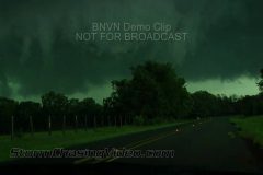
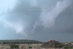
With several dozen tornado reports today, the severe storm outbreak hit Texas with numerous tornadoes. BNVN Weather Paparazzi Tim Baker was just west of Tyler Texas and caught this damage the area and covering the roads with debris.
In the video that Tim sent, it shows one of his classic shots where he setups just off to the side of a very large and ominous wall cloud that starts to develop into a multi-vortex tornado. Tim got out of the path of the developing tornado and documented the debris and aftermath of the storm.
To license this footage for broadcast, contact http://www.stormchasingvideo.com
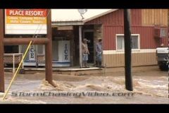
New video from BNVN Weather Paparazzi Justin Teague that shows various shots of flooding (including flooded structures) along the Illinois River near Tahlequah, OK with a short interview at the end with resident Tony Gage.
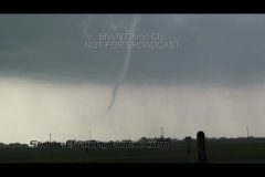
The severe storms continued on Monday with a deadly line of storms that formed tornadoes from central Arkansas, through Oklahoma to just south of Dallas, TX where BNVN Weather Paparazzi Tony Laubach was able to catch up with this rope tornado near Itasca, Texas.
In the video that Tony shot it starts out with a close up shot of the circulation on the ground in a field about a quarter mile away from him and then shows a wide shot of a bright white tornado hanging down from the clouds as the rain curtains fall behind the tornado. Tony has several different shots of the tornado from his dash camera and his chase partner, Ed Grubb’s camera.
The video ends as they are looking up to watch the rotation in the clouds above them after the tornado dissipated.
To license this footage, contact http://www.stormchasingvideo.com
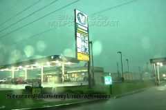
New video in tonight from Tim “Tornado Tim” Baker from Bowie, TX of a possible tornado and tornado damage. In the video from Tim, it shows the storm moving into the town and a lowering near the ground as the Tornado Sirens sound in the city.
After the storm moved out of Bowie, TX Tim found storm damage with debris in the road and signs damaged. The storm was powerful enough to rip a Interstate road sign away from it’s base and tossed into the middle of the road.
To license this footage for broadcast, contact http://www.stormchasingvideo.com
On Easter Sunday, BNVN Weather Paparazzi Tony Laubach was almost baptized by debris by the tornadoes that dropped down near Baird, TX.
In the video that Tony sent in, is shows tornadoes tearing across the Texas country-side along US-283 just north of the town of Baird, TX. Tony said several tornadoes touched down doing little damage over open country, but they kept people on their toes for the holiday, especially those between Abilene and Dallas.
The video starts out showing the first tornado north of Baird with various shots of the funnel cloud, touchdown, and debris swirl as it moves down a hill less then a quarter mile away from him. As the video continues, is shows two more tornadoes, including a white rope and a dramatic multi-vortex tornado on US-283.
The footage continues with POV or Point Of View shots as several vortices’s touch down and dance around on the east side of the highway as drivers approach from the south.
To license this footage, contact http://www.StormChasingVideo.com
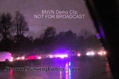
A prolific tornado-producing supercell raged across northern St. Louis Friday night and severely damaging the airport and causing havoc across the city.
In this video package shot by BNVN Weather Paparazzi that opens up with clips of I-70 on the east side of I-270 where a semi truck was blown over the median and closed the road while authorities worked on the detours around the damage and debris and various shots of traffic with lightning in the background. Tony said it took a while for traffic to start moving as a state trooper trying to get traffic to finally leave the area once the road was cleared.
The rest of the video package that Tony shot shows POV or Point of View shots as he chased the storms through the high winds, hail, and heavy rain to try and see the rain wrapped tornado during the daylight. He was able to see the wall cloud as the storm was approaching the Saint Louis metro area on the west side of town before it became rain wrapped and struck the area of the Lambert-St. Louis International Airport. The latest reports is airport is closed indefinitely while officials investigate the damage caused by the tornado.
To license this video, contact http://www.stormchasingvideo.com
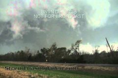
It was a very long night in the field for BNVN Weather Paparazzi Brandon Sullivan and his friends that were out chasing the line of severe storms that hit central and southeastern Oklahoma. Here is the full video of the Atoka and Tushka, Oklahoma tornado event that includes the dash camera footage.
A very large and destructive tornado caused extensive damage, multiple injuries and at least one fatality in Atoka county on Thursday.
The video starts out with the point of view dash camera footage as the drive up towards the town of Tushka, OK from the south side of the storm. At twenty two seconds into the video, lightning or a power flash lights up the storm and you can see a funnel cloud right in front of them.
They continue to keep driving towards the storm to follow the tornado when they see how close they were to the storm and at Fifty five seconds into the video, the stop rapidly to avoid driving into high tension power lines. The power lines were knocked down by the tornado and blocked the roadway. Just about at the one minute mark of the video, a Pickup Truck ends up driving through the power lines and a white SUV also drives into the power lines but stops almost in time to avoid hitting them. At the same time, a massive wall cloud and lowering is almost touching the ground only a few hundred yards in front of them on the road.
The dash camera footage continues for a while longer showing the vivid storm motion of the lowering of the mesocyclone. The POV footage when the chase team stops to check out a home that was destroyed by the tornado to see if anyone was trapped inside of the debris.
The rest of the footage is shot with the news cameras out the side of the truck as the mesocyclone was passing them. Same part as the POV shot but looking to the side of the storm as it passes them. Amazing footage of the storm motions as a extremely large tornado was on the other side of the tree line an heading for the town of Tushka and Atonka, Oklahoma.
After the tornado passes in second part of the video, extensive damage was found as debris littered the roadway and fields. The remaining part of the video shows some of the damage to Tushka, OK before the sun set and the chase team stopped documenting the storm damage to help out with the rescue efforts at the shelter.
To license this footage, contact http://www.stormchasingvideo.com
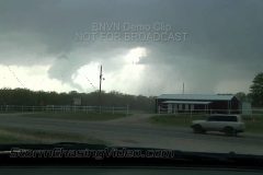
A several tornadoes touched down in Oklahoma and Kansas today causing extensive damage. In the town of Hominy, Oklahoma which is about 25 miles to the northwest of Tulsa, OK, BNVN Weather Paparazzi Tim Baker was chasing a rain wrapped tornado that touched down and knocked down power poles north of town. Tim observed extensive damage to the power poles homes, and barns.
To license this footage, contact http://www.StormChasingVideo.com
Today BNVN Weather Paparazzi Tony Laubach was on the severe storms that erupted across northern Oklahoma and southern Kansas bringing reports of huge hail and a few scattered tornadoes. One storm initiated near Enid and tracked east/northeast across northern Oklahoma. Video package that Tony shot includes scenes from this storm.
Opening shots of rotating wall cloud and funnel cloud near the town of Garber, Oklahoma. Shots include rapidly rotating wall cloud with several funnel shots.
Next shots are of insane hail from south of Hunter, Oklahoma. Opening POV shots as hail beings to fall as quarter-to-golfball. Video transitions as hail up to baseball size falls on vehicles and nearby fields. Scenes of cars on the side of the road as hail storm ends with giant hail falling from time to time. Last shots include hail with ruler and baseball and golfball hail in hand.
To license this footage, contact http://www.stormchasingvideo.com
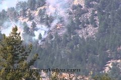
Fort Collins, CO & Bellvue, CO Crystal Mountain fire, media tour footage. In this video sent in by BNVN Weather Paparazzi Justin King who was part of the media tour that was given today at 3:00 pm, he accessed the most affected area of the fire where structures were lost. Video shows charred landscape, burned structure and car, more air support overhead, and at the end the on camera interview with the USFS PIO explaining the fire was originally 25 acres and exploded to 4500 with 90+ mph winds.
The second half of this video package is from a ridge line due east of the current burn area. The fire has laid down due to 3 inches of snow that fell the day prior, but as you can see now that has all melted away. In the time of filming this first clip parts of the fire were observed flaring up again. This package shows the helicopters doing water drops on the current active fire line. Access to the canyon was closed to all persons so this ridge line was the closest anyone can get for now. The area of the lake being used for water access is also secluded. Fire is estimated at 4,500 acres and is 15% contained as of 5:00 PM mountain time.
To license this footage, contact http://www.bnvn.com
On Sunday, BNVN Weather Paparazzi Tony Laubach was chasing the severe storms that broke out across Kansas that brought damaging winds, hail, and heavy rains. Over 200 reports of hail and high winds were reported during the day with a large cluster of reports coming from Kansas.
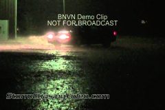
Video package includes nighttime storm footage from in and around the town of Allen, Kansas, about 40 miles southwest of Topeka.
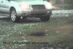
Video package opens up with clip of Allen city limit sign with hail falling. Subsequent shots of hail to near golfball size (1.50″) falling on the highway. One shot of a car as storm starts to end with headlights reflecting rain and hail. Two shots of hail in hand, including one sized up with a 4GB USB stick.
Several shots of smoldering fires caused by lightning strikes to trees. Several small fires were ignited along a metal fence guessed to be caused by a lightning strike. Various clips of smoldering stumps in rain, wind and some distant lightning.
Final shots include shots after dusk of a wall cloud and scud tags.
To license this footage, contact http://www.stormchasingvideo.com