- Hide menu

Archive for April, 2014

Out tracking the severe storms in the Midwest today and will be covering Illinois.

StormChasingVideo.com LLC no longer handles the Rights and Clearances for this footage.
To license this footage, contact stormtrackerben@gmail.com

Copyright 2014 LiveNewsVideoNetwork.com
*** NO THIRD PARTY USE W/O LICENSE ***
SID=BenM
TVID=CNN

Juston Drake and Simon Brewer “Storm Riders” are chasing in the Yazoo City, MS area this afternoon. A tornado warning is in effect and a tornado warning is southwest of Yazoo City right now. Epic severe weather event for 2014.

Live GPS tracking link:
http://www.livenewsvideonetwork.com/scvp/scv-stringers/juston-drake/live-track/

Copyright 2014 StormChasingVideo.com & LiveNewsVideoNetwork.com
*** NO THIRD PARTY USE W/O LICENSE ***
SID=JustonD
TVID=TWC,NBC,FOXNEWS

Deadly tornado outbreak pounds Mississippi: footage of 3 large tornadoes and supercells near/in the towns of Louisville, Columbus and Midway Mississippi. Also footage of close dramatic lightning strikes and tornado damage. This is second day of deadly severe weather after a record slow tornado year to this point.

All shots from afternoon & evening April 28, 2014 during daylight and 2 night shots near towns/cities of Midway, Louisville, and Columbus Mississippi

Shot List:

1. wide shot close lightning strike & Meteorologist Juston Drake’s reaction with supercell & wedge torndo in background near Louisville, MS
2. wide shot of close lightning strike (different angle) near Louisville, MS
3. timelapse wide shot of wide wedge tornado and incredible supercell structure near Louisville, MS
4. wide panning (right to left) shot of wedge tornado under incredible supercell thunderstorm structure near Louisville, MS
5. wide shot with blowing grass in foreground and wedge tornado in background near Louisville, MS
6. pushed-in shot of wedge tornado near Louisville, MS
7. wide shot of wall cloud and dramatic lightning strike near Columbus MS shortly before producing massive wedge tornado
8. wide timelapse shot of cars and tornadic supercell structure near Columbus MS
9. wide panning shot (left to right) of dramatic tornadic supercell structure and wall cloud near Columbus MS
10. wide timelapse of wall cloud and supercell structure near Columbus MS
11. POV driving shot of dramatic lightning bold near Columbus MS
12. wide shot of wall cloud and lightning near Columbus MS
13. pushed-in shot of wall cloud and tail cloud near Columbus MS prior to large tornado
14. wide angle POV driving shot of large wedge tornado with dramatic mesocyclone approaching Columbus MS
15. wide angle POV driving shot of large wedge tornado approaching Columbus MS with pieces of debris raining from sky
16. pushed-in POV driving shot of large wedge tornado approaching Columbus MS
17. pushed-in POV driving shot of large wedge tornado approaching Columbus MS with damaged trees in foreground
18. pushed-in shot of snapped utility pole from a large tornado with lightning flashes in background near Columbus MS
19. driving shot of damaged utility poles from large tornado near Columbus, MS
20. pushed-in shot of downed/snapped utility pole from large tornado near Columbus MS
21. pushed-in shot of shredded and downed trees from large tornado near Columbus MS
22. pushed-in shot of destroyed church from large tornado near Columbus MS
23. wide shot of snapped utility pole base in foreground with leaning poles, pink skies, and lightning flashes in background from large tornado near Columbus MS
24. pushed-in shot of emergency crews & fire truck in eastern Columbus MS with power outage from large tornado
25. pushed-in shot of emergency worker walking with flashing lights in Columbus MS with dark power outage from large tornado
26. wide shot of tornadic supercell structure passing over Midway MS
27. pushed-in shot of tornado and wall cloud near Midway MS
28. POV driving shot of heavy rain from tornadic supercell on typical Mississippi road lined with tall trees and no view near Louisville MS
29. wide shot of traffic on Highway 82 and “Columbus” MS highway sign with lightning flashes from tornadic storms in background

To license this footage, visit http://www.StormChasingVideo.com

SID: Simon Brewer / Justin Drake

A long-lived line of storms developed across Kansas early Sunday morning and trucked east into Missouri where it lead to numerous warnings and reports of wind damage.

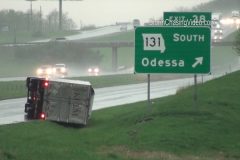
At 12:51pm, the National Weather Service issued a ‘TORNADO WARNING’ for a cell that had strong rotation on radar near Odessa along I-70. Damage was then reported in town, including an overturned semi at the Odessa exit and minor building/tree damage in town. A mobile home park on the east side of town had numerous homes damaged by the storm. Several trees were downed in town and there was also damage to a gas station. Initial reports as straight line winds, but radar indicated rotation over town at the time the damage was reported.

No injuries were reported.

Scene 1-2: Shots of overturned semi-truck with the Odessa exit sign next to it.

Scene 3-5: Various angles of overturned semi.

Scene 6: Panned shot of damaged gas station roof with metal peeled off.

Scene 7: Panned shot of debris on the ground up to the damage gas station roof cover.

Scene 8-10: Various shots of damaged gas station.

Scene 11-12: Shots of damaged roof on a mobile home in town.

Scene 13-14: Two angles of metal roofing bent around a sign post.

Scene 15: Panning shot from metal piece to a downed telephone/light pole.

Scene 16: Shot of downed power pole with line nearly fallen on a car.

Scene 17: Panning shot up downed pole.

Scene 18: Static shot of down pole.

Scene 19: Panned shot from broken wind on the ground to the damaged mobile home it came off.

Scene 20: Wide shot of mobile home with down tree in front yard.

Scene 21-22: Man dragging a tarp followed by shot of man stapling tarp to mobile home side damaged in the storm.

Scene 23: Shot of down tree in parking lot of bank.

Scene 24: Shot of bank sign with down tree.

Scene 25-30: Various shots of driving winds and rain on the interstate behind the damaging part of the storm.

Severe supercell thunderstorms develop after dark threatening the Southwestern Oklahoma city of Altus to begin what appears to be several significant severe weather days for the Central and Eastern U.S.A. Footage captures frequent lightning with several spectacular “anvil crawlers” as the severe-warned supercell thunderstorm passes over and near Altus, OK. Also, footage of extremely high winds gusting to 45 and 50 MPH over the Altus area as Gulf of Mexico moisture flowed into region prior to the development of severe storms.

All shots were taken in/near Altus, OK on evening and night of April 26, 2014 (daylight and night shots)

Shot List:

1. wide shot of “City of Altus” road sign lit by lights at night with lightning from severe supercell thunderstorm in background in Alutus, OK
2-50. variety of frequent night lightning shots with several “anvil crawlers” from a severe supercell thunderstorm over Altus, OK
51. pushed-in shot of American Flag flapping furiously in high winds near Altus, OK before severe storms developed along dryline boundary
52. pushed-in shot of American Flag flapping furiously in high winds near Altus, OK before severe storms developed along dryline boundary
53. wide shot of trees swaying in high winds near Altus OK prior to severe thunderstorm development
54. pushed-in shot of trees swaying in high winds near Altus OK prior to severe thunderstorm development
55-57. various shots of wind turbines spinninng quickly in high winds prior to the development of severe supercell thunderstorms near Altus, OK
58-60. various shots of wheat field waving in high winds prior to severe thunderstorm development near Altus, OK

Chasing in the chasing with tony in western OK and Tx Panhandle. Supercells developing with very large hail likely. Radar already estimating 3″ plus.

StormChasingVideo.com LLC no longer handles the Rights and Clearances for this footage.
To license this footage, contact stormtrackerben@gmail.com

Copyright 2014 LiveNewsVideoNetwork.com
*** NO THIRD PARTY USE W/O LICENSE ***
SID=BenM

Severe supercell thunderstorms hit the Texas-Oklahoma border region with large hail, high winds and dangerous lightning. Two powerful storms were documented near Wellington, TX and Wichita Falls, TX creating a hazardous evening for people in the Western Oklahoma and Northwest Texas area.

All shots during afternoon and evening of April 23, 2014 during daylight on OK/TX border near Wellington, TX and near/in Wichita Falls, TX

Shot List:

1. driving shot of wall cloud TX/OK border east of Wellington, TX
2. panning wide shot of “beaver’s tail” inflow band and supercell structure on OK/TX border near Wellington, TX
3. wide shot of dirt plumes caused by strong downdraft winds from supercell thunderstorm on OK/TX border near Wellington, TX
4. pushed-in shot of dirt plume caused by strong downdraft winds from a supercell thunderstorm on OK/TX border near Wellington, TX
5. POV driving shot of blowing dirt over road obscurring visibility from severe thunderstorms on OK/TX border near Wellington, TX
6. wide shot of wall cloud and severe storm on OK/TX border on OK/TX border near Wellington, TX
7. pushed-in shot of wall cloud on OK/TX border near Wellington, TX
8. wide shot of wall cloud and supercell thunderstorm on OK/TX border near Wellington, TX
9. wide shot time-lapse of approaching wall cloud on OK/TX border near Wellington, TX
10-12. pushed-in shots of hail bouncing & shattering on road & covering road near Wichita Falls, TX
13. pushed-in shot of hail bouncing in tall grass near Wichita Falls, TX
14. pushed-in shot of hail accumulating on road near Wichita Falls, TX
15. wide shot of hail falling with patially obscurred sun in background near Wichita Falls, TX
16. pushed-in shot of cars driving on road with hail falling and bouncing in nearby grass near Wichita Falls, TX
17. POV shot of herd of cattle crossing road after escaping enclosure from falling hail near Wichita Falls, TX
18. pushed-in shot of escaped cattle with falling hail and rain on side of road near Wichita Falls, TX
19. pushed-in shot of “Wichita Falls” sign with falling hail and rain near Wichita Falls, TX
20-24. POV driving shots of storm and lightning in Wichita Falls, TX
25. wide shot of oil pumpjack in foreground with severe-warned supercell thunderstorm wall cloud in background near Wichita Falls, TX
26. wide shot of sunset with supercell thunderstorm structure and hail shaft near Wichita Falls, TX
27. pushed-in shot of partially obscurred sunset from rain and hail near Wichita Falls, TX
28. wide shot of supercell thunderstorm and hail shaft near Wichita Falls, TX

To license this footage, visit http://www.StormChasingVideo.com

Juston Drake and Simon Brewer “Storm Riders” are out chasing in the Texas panhandle today were severe storms are already underway.

Live GPS tracking link:
http://www.livenewsvideonetwork.com/scvp/scv-stringers/juston-drake/live-track/

Copyright 2014 StormChasingVideo.com & LiveNewsVideoNetwork.com
*** NO THIRD PARTY USE W/O LICENSE ***
SID=JustonD

A long-track supercell developed as part of a small regional severe weather outbreak. This storm formed in the southeastern Texas Panhandle and crossed into Oklahoma as a hailer, dumping copious amount of wind-driven hail up to golfball sized and accumulated that hail several inches deep on area roads. This storm system is a teaser to what is expected to be a very active weekend across the Plains.

Video shot in Harmon County, OK about 15 miles south of Erick, Oklahoma.

Scene 1-3: Establishing shots of a loosely organized wall cloud and ominous clouds.

Scene 4: Shot of the Harmon County, OK county limit sign along OK-30.

Scene 5: Shot during the storm of the HWY-30/RD-1400 sign.

Scene 6: Wide shot with a stop sign as hailstorm gathers steam.

Scene 7-11: Various shots of heavy falling hail up to golfball size falling, bouncing off the ground, and NAT sounds of it hitting car.

Scene 12: Shot of embankment covered in several inches of hail.

Scene 13: Shot of two vehicles pulled over toward end of storm with hail covering highway.

Scene 14: POV driving shot approaching pulled over vehicles by hail-covered road.

Scene 15: POV drive shot showing heavy hail accumulation on highway.

Scene 16-18: POV driving shots following vehicles/vehicles passing on hail covered highway.

Scene 19: Shots toward end of storm showing cracked windshield with hail accumulation in backdrop.

Dangerous tornadic supercell thunderstorms ruin Easter Sunday celebrations over Northwest Texas and Southwest Oklahoma near Childress, TX pounding the area with tornadoes, high winds, and large hail. The tornadic storms tracked across the Red River from Northwest Texas into Southwest Oklahoma causing hazardous driving conditions for holiday travelers, Easter egg hunts, and family gatherings.

All Shots in daylight during afternoon/evening of April 20, 2014 Easter Sunday, near Childress TX in Northwest Texas and Southwest Oklahoma

Shot List:

1. Pushed-in shot of “Childress County Line” sign with rain falling near Childress TX
2. wide shot of tornadic supercell near Childress TX with blowing dust from severe winds, scud clouds, and hail shaft
3. wide panning left to right shot of incredible striated tornadic supercell structure near Childress TX on Oklahoma border
4. wide shot of rotating wall cloud, tail cloud, and supercell near Childress TX on Oklahoma Border over Red River
5. wide shot of layered mesocyclone and rotating wall cloud on Oklahoma border near Childress TX
6. wide shot of ominous supercell shelf cloud and mesocyclone over Southwest Oklahoma near Childress TX
7. wide shot with “stop” sign and mesocyclone with rain and dust blowing from tornadic supercell over Southwest Oklahoma near Childress, TX
8. pushed-in shot of inflow bands into tornadic supercell near Childress TX
9. wide panning-shot from right to left over blowing wheat field showing incredible tornadic supercell structure near Childress TX
10. pushed-in shot of developing wall cloud and several lightning bolts near Childress TX
11. pushed-in shot of rotating wall cloud and deep green rain/hail shaft over dirt road near Childress, TX
12. pushed-in shot of ground-scraping tail cloud feeding into rotating wall cloud near Childress TX
13. pushed-in shot of car driving by rotating wall cloud moving over road near Childress, TX
14. pushed-in shot of rapidly rotating wall cloud over road near Childress, TX
15. wide shot of dangerous rotating wall cloud close to road near Childress TX
16. POV driving shot of wall cloud over car and road near Childress, TX
17. pushed-in shot of heavy rain and hail shaft racing over open fields near Childress, TX
18. pushed-in shot of dust cloud blown by severe winds with tornadic supercell near Childress, TX
19. wide shot of rain and hail bands slamming road and powerlines near Childress, TX
20. pushed-in shot of rain and hail slamming road near Childress TX
21. pushed-in shot of rain and hail pounding road near Childress TX
22. pushed-in shot of hail bouncing on road and grass in Childress, TX
23. wide shot of bouncing hail on road near Childress TX
24. wide shot of herd of cattle in foreground and wall cloud and hail shaft in background near Childress, TX
25. pushed-in shot of nervous cow as rotating wall cloud and tornadic supercell rapidly approaches near Childress TX
26. POV wide driving shot of gustnado and supercell thunderstorm near Childress, TX
27. POV driving shot of heavy rain and hail pounding car in Tornadic supercell near Childress, TX
28. pushed-in shot of Texan and American flags with windmill blowing in wind ahead of approaching supercell thunderstorm near Childress TX

Live feed from Simon Brewer and Juston Drake who are chasing in the storms in the around the Childress, TX area today.

Live GPS tracking link:
http://www.livenewsvideonetwork.com/scvp/scv-stringers/juston-drake/live-track/

Copyright 2014 StormChasingVideo.com & LiveNewsVideoNetwork.com
*** NO THIRD PARTY USE W/O LICENSE ***
SID=JustonD
TVID=

Recent rains across southern IL were enough to raise rivers last week, but many areas are deceptively dry as displayed on Saturday where several brush fires were ignited keeping area fire crews busy. Even with wet soil, much of the top brush and some grass fields remain good fuel for fires as they remain dry even with the recent rains. Video package includes scenes from two southern IL brush fires on Saturday, one early in the afternoon in Williamson County south of Marion and the other late evening near the town of Christopher.

PART 1: Evening fire near Christopher in Franklin County (0:00-2:23)

Suspected Cause: Passing train created sparks that ignited nearby dry grass and spread. According to Captain Tom Crawford, approximately 10-15 acres burned in this fire which was contained and put out in about 3 hours. Fire had burned trees to the point where they were in jeopardy of falling down into the railroad tracks. Crews had to cut down several trees to prevent them from coming down on the tracks. The tracks were shut down for several hours to allow crews to fight the blaze. Because of the lack of access roads, ATVs and water backpacks had to be used to fight the flames.

Scene 1-2: Establishing shots of fire trucks, including second scene with railroad crossing gate in foreground.

Scene 3: Fire crews on ATVs working their way down the railroad tracks.

Scene 4: Looking down the railroad tracks through thick smoke at fire crews.

Scene 5: Fire crews through thick smoke dousing small hot spots with water backpacks.

Scene 6: ATV and firefighter near tracks.

Scene 7: Fire fighter climbing steep embankment to get to a tree.

Scene 8: Fire fighter pushing and kicking a tree to the ground to prevent it from burning and falling onto the tracks.

Scene 9: Wide shot of another couple fire fighters knocking down a tree to prevent it from coming down on the tracks.

Scene 10: Close up of backpack fire fighter dousing flames.

Scene 11-12: Fire fighter tosses a smoldering piece of wood and another hits it with the hose.

Scene 13: Cool panning shot up the water of a hose to a close-up of a fire fighter.

Scene 14-16: Various shots of flames in the burn area.

PART 2: Afternoon fire in Williamson County south of Marion (2:23-4:24)

Suspected Cause: A nearby resident was control burning grass when a shift in the winds sent the fire down the hill and into a wooded area with some trash also catching fire. This fire was contained and put out within about 2 hours.

Scene 1-2: Establishing shots of fire trucks, panning and static.

Scene 3-4: Several fire fighters with hoses near fire.

Scene 5: Two fire fighters make their way down a steep slope to get to a burning area.

Scene 6: Same two fighters hosing flames in ravine.

Scene 7: Cool shot of fire fighters appearing through very thick smoke.

Scene 8: Closer shot of two fire fighters in thick smoke that makes them appear and disappear.

scene 9: Fire crews dousing flames.

Scene 10: Looking straight on as a fire fighters shoots water on flames.

Scene 11: Shot of fire.

Scene 12: Smoke overtakes camera.

Verne Carlson in Golden Colorado testing out the first ever quadcopter drone live stream to YouTube LIVE.

Copyright 2014 StormChasingVideo.com & LiveNewsVideoNetwork.com
*** NO THIRD PARTY USE W/O LICENSE ***
SID=VerneC
TVID=

Live footage from the late season powerful winter storm that is hitting the area around Saint Cloud, MN with up to 8 to 10 inches of new snow.

This winter storm feed will up up until sunset today to cover the event during daylight hours.

Live GPS tracking link:
http://www.livenewsvideonetwork.com/scvp/scv-stringers/doug-kiesling/live-track/

Copyright 2014 StormChasingVideo.com & LiveNewsVideoNetwork.com
*** NO THIRD PARTY USE W/O LICENSE ***
SID=DougK

After almost all of the snow from this winter had melted and the lakes were beginning to open up from being covered in ice, the latest snowstorm just dumped more than a foot of snow on parts of central Minnesota.

Over a foot of new heavy wet snow covered the ground just north of the Minneapolis and Saint Paul metro area today. The snow caused numerous wrecks all across the north metro region along the Interstate 94 and Highway 10 corridor.

Clip 1 Achman Lake, along Interstate 94 near Avon, MN was starting to refreeze with the latest round of winter weather.

Clip 2 Overhead shot of a snow plow on Interstate 94 that is joined by a State Trooper to help clear the road and control the flow of traffic in Saint Cloud.

Clip 3 Drive Side Camera passing a snow plow on Highway 23 in Saint Cloud.

Clip 4 – 5 Jeep deep in a ditch along Interstate 94 in near Avon, MN.

Clip 6 Stickworks at Saint Johns University covered in snow.

Clip 7 Car stuck in the ditch near Saint Cloud, MN on Interstate 94

Clip 8 – 16 Various shot of a Semi truck slid off the road and lost traction on Highway 10 near Clearwater MN.

Shots include State Trooper arriving on scene. Wide shot of the tractor trailer blocking the east bound lanes of highway 10. Tight shot on State Trooper squad car. Truck drivers trying to chain up the wheels to get traction and the truck driver backing up and out of the way to open up the highway.

Clip 17 Snow plow on Highway 10 near Clear Lake, MN

Clip 18 POV shot of driving in heavy snow on Interstate 94 near Avon, MN.

Clip 19 Truck in the center ditch on Interstate 94 near Saint Jospeh, MN.

Clip 20 POV shot of the State Patrol on the scene of a spin out on Interstate 94 in Saint Cloud, MN.

Clip 21 POV shot of a SUV almost losing control while passing another vehicle that spun out in the center ditch near Clearlake, MN on Interstate 10

Clip 22 POV car in the ditch near Clearlake, MN on Interstate 10

Clip 23 POV Snow plow on Interstate 10 in Saint Cloud, MN

Clip 24 Car in the center ditch on highway 23 in Saint Cloud, MN.

Another major winter storm system is impacting the central Minnesota region this afternoon with heavy wet snow. While the heart of the Twin Cities metro area is escaping this latest winter storm system, the northwest suburbs are taking the full brunt of the storm in the Saint Cloud, MN area.

While this is one of the, if not last winter storm of the season, after the recent warm up and rain, the road surfaces are acting as if this is the first winter storm of the season.

Clip 1 POV shot with voice over talking about the road surfaces.

Clip 2-4 Roll over accident with a pickup truck on its roof.

First clip tight on a no parking sign and pull back to the truck on the roof as the heavy snow covers the lens.

Second clip and third clip, static shots of the truck on its roof.

Clip 5 Low shot of snow plow passing by the camera in downtown Saint Cloud, MN.

Clip 6 – 7 Car vs. Telephone Pole, Telephone utility pole won. Shots of a car that smashed into a utility pole and the front end is destroyed.

Clip 8 State Patrol squad car on Interstate 94 taking up both lanes to keep traffic at a slow speed for safety.

Clip 9 POV Snow Plow on Interstate 94

Clip 10 Snow plow passing by under the camera from an overpass on I94.

Clip 11 Outside Right camera passing a snow plow.

Clip 12 POV Passing a snow plow.

Clip 13 – 15 Aftermath of several vehicles that crashed into a snow plow on highway 10 on the east side of Saint Cloud.

Clip 16 – 17 Vehicle in the ditch on Highway 10.

Clip 18 People out running in the snow in downtown Saint Cloud, MN.

Clip 19 People walking in the snow in downtown Saint Cloud, MN. One of them has an Umbrella.

Clip 20 Snow plow in downtown Saint Cloud.

Clip 21-22 POV driving in heavy snow.

To license this footage, visit http://www.StormChasingVideo.com

Unseasonably cool weather has filtered into southern Illinois in the wake of a weekend cold front that brought over a half inch of rain over the weekend. While the sun was out and it looked deceptively mild, chilly temps and a brisk wind made it feel very un-Spring like.

Temperatures overnight prompted Frost and Freeze warnings across the southern part of the state as overnight lows dropped into the low 30s in many areas. High temperatures were 25-30 degrees below the normal readings which usually sit near 70-degrees. While temperatures will struggle to get out of the 40s, overnight lows in the freeze warning areas may drop into the upper 20s, approaching record lows for many towns and be 20 degrees or more below average for this time of year.

Video package shot in the town of Herrin, Illinois which is approximately 2 hours southeast of St. Louis near the city of Marion.

Scenes 1-2: Shots of Herrin bank signs showing temperatures between 41-42 degrees around the noon-1pm timeframe.

Scene 3: Wide shot of downtown Herrin with a man walking and budding trees behind traffic.

Scene 4: Woman in a doggie pull over getting into a car.

Scene 5: Man on a bike in a hoodie with the hood on his head riding across the street.

Scene 6: Woman in a hoodie getting into a car.

Scene 7: Woman with gloves and a jacket fighting the blustery conditions to unload a shopping cart.

Scene 8: Man in a jacket and beanie walking.

Scene 9: Man in long sleeves at a car wash.

Scenes 10-11: Two guys in jackets loading a truck.

Scene 12: Man in a jacket walking.

Scene 13: Woman in a long jacket standing at a car.

Scene 14: Two bundled up women walking to a car.

Scenes 15-16: Wide shots of traffic in downtown Herrin.

Scene 17: Shot of an American flag blowing in the chilly breeze.

A full Lunar Eclipse creates a surreal scene over the Old Capitol building in down town Iowa City. Students from the university brave the 30 degree cold to view the rare sight as photographers take advantage of the beautiful foreground of the Old Capitol building.

Scene 1: A photographer braves the cold for the perfect Moon shot.

Scene 2: Photographer working camera.

Scene 3: Moon and Mars next to the Old Capitol with a photographer.

Scene 4: Slow zoom of photographer with Old Capitol.

Scene 5: Students laying on lawn with blankets and hats to view eclipse.

Scene 6: Students gather outside of the Old Capitol building.

Scene 7: Down town streets are quiet except for the anticipation of a few star gazers.

Scene 8: Moon Time lapse

Scene 9: Moon with American flag waving.

Scene 10: Panning image up to the Old Capitol golf roof with the copper Moon.

Scene 11: Street lights with the Moon in the background.

To license this footage, visit http://www.StormChasingVideo.com

Severe storms and tornadoes strike Oklahoma Sunday evening. Severe storms produce high winds, large hail, heavy rain, frequent lightning, and even tornadoes across Central and Southern Oklahoma. The most powerful storms hit near the city of Marietta in southern Oklahoma.

All scenes were shot on evening of April 13, 2014 in Southern Oklahoma in/near the city of Marietta during daylight and dusk.

Shot list:

1 & 2. POV driving shot of tornadic storm structure near Elmore City, OK; the storm had just produced a tornado near Velma, OK
3. Panning shot from right to left showing dramatic shelf cloud from a tornadic storm near Marietta, OK
4-7. various wide shots of tornadic storm structure as storm overtakes shooter position near Marietta, OK
8-11. various pushed-in shots of wall clouds near Marietta, OK
12. pushed in shot of wind driven rain and hail from a tornadic storm near Marietta, OK
13-15. various POV driving shots of heavy rain and hail falling on road and car during a tornadic thunderstorm near Marietta, OK
16 & 17. wide POV driving shots of arcus cloud from tornadic storm near Marietta, OK
18. POV driving shot of downtown area of Marietta, OK with lightning flashes from a tornadic storm
19. pushed-in shot of scud fingers moving over road into a wall cloud near Marietta, OK
20. pushed-in shot of large funnel cloud east of Marietta, OK
21. pushed-in dark shot of heavy rain and hail falling in front of car headlight during a tornadic storm near Marietta, OK
22. pushed-in colorful sunset shot with plants in foreground blowing in wind with storm clouds around sun near Marietta, OK
23. wide shot of mammatus clouds over Marietta OK with lightning flashes
24. pushed-in shot of mammatus clouds near sunset over Marietta, OK
25. wide shot of backside of tornadic storm with lightning east of Marietta, OK
26. wide shot of “Marietta City limit” sign with storm anvil & lightning flashes in background
27. pushed-in shot of “pump jack or oil pump” with storm clouds in background near Marietta, OK

Sunny skies and 60F degrees reach Iowa City ushering in a much anticipated Spring day. Scenes filmed around the University of Iowa Campus.

Scene 1: Bank sign displaying a 60F temperature at 12:55 PM CDT

Scene 2: A wide shot showing the busy street below the bank sign

Scene 3: A collection of mopeds near campus

Scene 4: Close up shot of mopeds

Scene 5: A zoom out show of the Old Capitol building in downtown Iowa City

Scene 6: Flag in a gentle northerly breeze

Scene 7: Students soaking up the sunlight

Scene 8: Students studying out doors

Scene 9: Students hang out on Campus

Scene 10: Students studying outdoors

Scene 11: Student sitting outside

Scene 12: Old Capitol building with bicyclist

Scene 13: Fair weather cumulus clouds over Iowa city

Scene 14: Enjoying the day

Scene 15: Students on campus

Scene 15: Students on campus

Scene 16: Bicycle racks nearly full

Scene 17: Squirrel climbs tree

Scene 18: Squirrel eating an Easter egg?

Major Spring tornado strikes Farmersville, TX causing widespread damage. Several tornadoes touched down near Farmersville, TX causing significant damage to property and homes. A family near Farmersville were rescued from their demolished home near Farmersville.

All shots in late evening and night in and near Farmersville, TX associated with a large tornado and parent supercell thunderstorm

Shot List:

1. wide shot of rotating wall cloud approaching Farmersville, TX shortly before producing tornadoes

2. wide shot of funnel cloud over Farmersville

3. wide shot of traffic fleeing tornadic supercell thunderstorm over Farmersville, TX

4. POV wide shot of very high winds driving rain and hail in traffic with tornado close by in Farmersville, TX

5. Wide shot of large tornado northeast of Farmersville, TX

6-13. various shots of “powerflashes” caused by damaging tornado in and near Farmersville, TX destroying powerlines and transformers

14-17. various lightning shots as tornado causes damage after dark near Farmersville, TX

18-22. various shots of tornado damage (mostly tree damage) between Farmersville, TX and north of Greensville, TX

23-28. various shots of emergency personel and vehicles at tornado damaged areas removing debris and searching for survivors near Farmersville, TX

29. Wide shot of “Greensville” TX city sign with lightning and storm in back ground

31-33.various shots of powerlines damage by tornado near Farmersville, TX

34. wide shot of “Farmersville” TX city sign

35. wide driving shot of tornadic supercell over Farmersville, TX

36. wide driving shot of several large powerflashes from Farmersville, TX tornado

To license this footage, visit http://www.StormChasingVideo.com

A powerful winter storm system hit central Minnesota hard Thursday afternoon and created hazardous travel conditions.

Footage shot around Stearns County, MN of the travel hazards on Interstate 94 as the winter storm started up Thursday afternoon.
Clip 1 Sauk Centre MN City Limits Sign with snow.

Clip 2 POV Driving by a car crash with State Patrol on the scene and a snow plow coming towards the camera.

Clip 3 POV shot driving by a car crash

Clip 4 Flag blowing in the wind with heavy snow

Clip 5 Heavy snow with trees in the foreground

Clip 6 Traffic on Interstate 94

Clip 7 – 10 Road signs covered in snow

Clip 11 Side camera passing a snow plow.

Clip 12 POV snow plow

Clip 13 POV snow plow tight shot on the blade

Clip 14 Side camera shot with snow plow and state patrol as the camera rolls by a crash.

Clip 15 Side camera passing a snow plow

Clip 16 POV passing a wreck in the center of the interstate

Clip 17 POV Passing a snow plow

Clip 18 Snow plow

Clip 19 POV driving in heavy snow

Clip 20 POV passing a snow plow kicking up a lot of snow and creating whiteout conditions.

To license this footage, visit http://www.StormChasingVideo.com

Juston Drake and Simon Brewer are near Paris Texas as a tornado warned storm approaches the area. Live storm chasing. Tornado season 2014. Farmersville Texas Tornado event. Tornadoes on the ground. Power Flashes. Live severe weather.

Live GPS tracking link:

http://www.livenewsvideonetwork.com/live-tracking-justond

Copyright 2014 StormChasingVideo.com & LiveNewsVideoNetwork.com
*** NO THIRD PARTY USE W/O LICENSE ***
SID=JustonD
TVID=TWC

Chasing the severe weather forming at the Texas and Oklahoma border. Live storm chasing video. Two camera angles. 2014 tornado season.

StormChasingVideo.com LLC no longer handles the Rights and Clearances for this footage.
To license this footage, contact stormtrackerben@gmail.com

Copyright 2014 LiveNewsVideoNetwork.com
*** NO THIRD PARTY USE W/O LICENSE ***
SID=BenM
TVID=