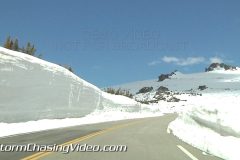
Colorado Rocky Mountain National Park Trail Ridge Road is finally open for the season. Even though the road is now open, the snow pack is extremely high along the sides of the trail.
Clips 1-2 South Navey Hill Rocky Mountain National Park
Clip 3 Trail Ridge road Beaver Meadow passing bicyclists heading up
Clip 4 Trail Ridge road wet from melting snow
Clip 5 Trail Ridge road snow on side of road as car passes by
Clip 6 Trail Ridge road snow on side of road as cars pass by
Clip 7 Trail Ridge road about 35 seconds of Deep snow on side of road in a forest of trees
Clip 8 Trail Ridge road deep snow on edge of road motorcyclists on side of road
Clip 9 Trail Ridge road passing cyclist
Clip 10 Trail Ridge road Rainbow Curve line of cars going up passing snow plow
Clip 11 Trail Ridge road Rainbow Curve passing walkers on side edge or road
Clip 12 Trail Ridge road passing snow plow high up mountain pass
Clip 13 Trail Ridge road extremely deep snow both sides of road alpine tundra level about 60 seconds
Clip 14 Trail Ridge road extremely deep snow following car along 15 foot wall of snow
Clip 15 Trail Ridge road Forest Canyon overlook 105 seconds of panoramic view from top
Clip 16 Trail Ridge road Forest Canyon overlook couple walking on snowy ridge
Clip 17 Trail Ridge road Forest Canyon overlook couple being photographed by friend
Clip 18 Trail Ridge road Forest Canyon overlook couple walking on snowy ridge
Clip 19 Trail Ridge road Forest Canyon overlook feet of people walking on snowy ridge
Clip 20 Trail Ridge road Forest Canyon overlook feet of people playing in snow
Clip 21 Trail Ridge road Forest Canyon overlook feet of people playing in snow
To license this footage, visit http://www.StormChasingVideo.com
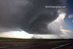
Footage of monster striated supercell thunderstorm producing damaging baseball-sized hail, severe high winds, large gustnadoes, and a haboob along Interstate 80 in western Nebraska in/near the towns of Chappell & Kimball, NE. Large baseball & tennis ball size hail shatters car windshield in Chappell, NE. Haboob & gustnadoes from severe winds make driving dangerous on I-80.
All footage from afternoon/evening near Chappell & Kimball, NE during daylight on May 19, 2014, run time 3:41 minutes, file size: 425 MB
Shot List:
1. wide shot of monster supercell with lightning strike over Interstate 80 near Chappell, NE
2. wide shot of monster supercell over I-80 near Chappell, NE
3. wide panning shot (from left to right) of striated monster supercell with lightning strike over traffic approaching Chappell, NE along I-80
4. wide shot of traffic on I-80 passing under monster striated supercell near Chappell, NE
5. wide shot of striated shelf cloud bearing down on Chappell, NE
6. pushed-in shot of wind-driven large hail, rain & debris racing past oncoming traffic in Chappell, NE
7. pushed-in shot of police truck driving through wind-driven large hail, rain, and debris in Chappell, NE
8. pushed-in shot of large hailstone held next to shattered windshield in Chappell, NE
9. pushed-in shot of large damaging hailstones (2+ inches in diameter) held next to measuring ruler in Chappell, NE
10.wide panning shot (left to right) from outside to inside car showing shattered windshield from massive hailstones in Chappell, NE
11. wide POV driving shot of large dust cloud with gustnado, wall cloud, and mesocyclone from large supercell near Chappell, NE
12. wide POV driving shot of large dust cloud with gustnado & wall cloud near Kimball, NE
13. pushed-in driving shot of large gustnado near Kimball, NE
14. pushed-in driving shot of large gustnado near Kimball, NE
15. wide shot of amazing supercell structure with large gustnadoes near Kimball, NE
16. POV driving shot of large dust cloud & gustnado & supercell on Interstate 80 near Chappell, NE
17. POV driving shot of large gustnado with construction sign knocked to ground by damaging winds near Chappell, NE
18. wide POV driving shot of large gustnado & construction barrel knocked over by high winds near Chappell, NE on I-80
19. wide POV driving shot of large gustnado over I-80 with traffic near Chappell, NE
20. timelapse POV driving shot of large gustnado & supercell over I-80 near Chappell, NE
21. timelapse POV driving shot into gustnado on I-80 near Chappell, NE
22. pushed-in POV driving shot of tumbleweeds, dust, & debris blowing over I-80 with traffic from severe winds & gustnado
23. pushed-in driving shot of large “haboob” dirt cloud behind trees approaching I-80 with supercell near Chappell, NE
24. pushed-in POV driving shot of traffic on I-80 with debris & massive “haboob” dirt cloud blowing over highway from severe winds with supercell near Chappell, NE
25. wide driving shot of supercell gust front approaching Chappell, NE
26. wide shot of windmill with supercell wall cloud in background
27. pushed-in shot of windmill spinning with supercell wall cloud in background
28. wide shot of cattle with supercell in background
29. pushed-in shot of cattle with supercell in background
30. pushed-in shot of “I-80” highway sign with supercell thunderstorm in background
To license this footage, visit http://www.StormChasingVideo.com
To help support our freelancers, buy them coffee. https://www.buymeacoffee.com/stormchasing
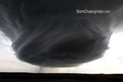
Intense footage of damaging, wind-driven baseball-sized hail pounding car & location from incredible low precipitation supercell (LP Supercell) with cone funnel cloud southwest of Newcastle, WY. Winshield is shattered by baseball-sized hail and footage of tumbleweeds, hail, & debris blown at high velocities past vehicle.
All footage shot during afternoon/evening during daylight of May 18, 2014 near/southwest of Newcastle, WY
Shot List:
1-3. various wide shots of incredible low precipitation supercell structure with mesocyclone and wall cloud southwest of Newcastle, WY
4. wide time lapse shot of incredible supercell structure southwest of Newcastle, WY
5. wide shot of cone funnel cloud & rotating wall cloud near Newcastle, WY
6. pushed-in shot of cone funnel cloud under rotating wall cloud with hail falling near Newcastle, WY
7. pushed-in shot of cone funnel cloud near Newcastle, WY
8. wide shot of rotating wall cloud, dirt kicked up by high winds, & baseball-sized hail falling & shattering on ground near Newcastle, WY
9. wide shot of intense baseball-sized hail battering location & shattering on ground with sounds of hail damaging car near Newcastle, WY
10.pushed-in POV shot of large hail smashing against & shaking windshield
11 & 12. wide (high looking down) shots of baseball-sized hail smashing against car breaking windshield & shattering on road, with high winds
13.wide (low) shot of baseball hail pounding car & shattering on roadway with high winds
14.pushed-in POV shot of large hail bouncing on road & grass with high winds blowing debris & tumbleweeds
15 & 16. wide shots of rotating wall cloud & high winds blowing large hail, debris, & tumble weeds past camera
17.pushed-in POV driving shot of hail-covered highway & large hail falling
18.pushed-in POV driving shot of large hail shattering & accumulating on highway
19.wide POV driving shot of rotating wall cloud in background with shattered windshield from baseball-sized hail in foreground
20.pushed-in shot of shattered windshield from baseball-sized hail in foreground with setting sun in background
21.pushed-in shot looking down on shattered windshield from baseball-sized hail
22.pushed in shot of shattered wind shield from baseball-sized hail
23.pushed-in shot of large dent with chipped paint from baseball-sized hailstones
24.pushed-in panning shot (from right to left) following running Pronghorn deer (called American Antelope) ahead of dangerous supercell thunderstorm near Newcastle, WY
25.pushed-in shot of “Newcastle” Wyoming city road sign
SID: StormRiders
http://www.stormchasingvideo.com/scv-merch-store/
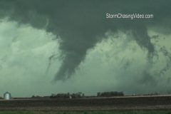
Video package of tornadic supercell thunderstorms near the town of Grafton in SE Nebraska.
Video includes:
1) tornado with brief touchdown near Grafton Nebraska
2- 6) shots of wildly rotating mesocyclone and funnel clouds; sirens sounding in the town of Geneva.