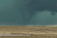
A massive supercell developed southwest of Lamar, Colorado and intensified bringing hail up to baseball size, several funnels, and a large tornado that appeared long enough to get a view before the rain and hail wrapped it up. The tornado that touched down lifted before it reached US-287 south of Lamar and didn’t do any reported damage. The hail grew to baseball size and damaged car windshields as that core did make it across US-287.
Scene 1: Shot of large tornado southwest of Lamar in Prowers County, Colorado.
Scene 2-4: Shots of funnel clouds from the storm prior to the tornado, two confirmed before the tornado formed.
Scene 5: Structure shot of storm as it approached US-287 south of Lamar.
Scene 6-10: Various shots of large hail, up to baseball size, falling during the storm.
Scene 11: Shot of cracked windshield during hailstorm.
Scene 12: High winds in the trees as the storm rages on.
Scene 13: Shot of five large stones collected after the storm, one measuring 2.5″
Scene 14: Shot of two stones compared to a blue golfball and a lime.
Scene 15: Narration with radar behind hail in hand.
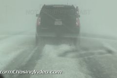
A supercell with massive hail unloads on the town of Pecos and surrounding areas dumping 2-inch plus hail accumulating a foot deep. US-285 was brought to a crawl due to accumulating hail with several vehicles stuck on the side of the road. Motorists in navigating through the hail took upwards of an hour to drive just a few miles, left to drive in hail ruts so deep that lower-clearance cars were scraping hail they went over.
Video package includes shots of US-285 south of Pecos during the end of the storm when rain and hail were still falling, but accumulations had occurred and hail fog had reduced visibility to less than a tenth of a mile.
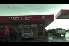
Also includes shots of the Loves Truck stop in town where the northern part of the storm clipped dropping large hail on the truck stop. Shows various people hiding beneath a gas station.
Several shots at the end include some of the 2-2.25″ stones found on the ground.
SID: Tony Laubach
Footage of large multi-vortex wedge-shaped tornado, two tornadoes down simultaneously, long-track tornado, violent supercell thunderstorm, large hail, and dramatic lightning in northern Texas. The tornadoes occurred between Decatur and Denton Texas near the small towns of Bluett and Bolivar.
All footage shot in evening daylight (night lightning) on May 7, 2015 near Bluett and Bolivar, TX.
Shot List:
1-5. various shots of large wedge-shaped tornado west of Bolivar, TX
6-10. various shots of multiple vortex tornado/wedge-shaped tornado west of Bolivar, TX
11. shot of large wedge-shaped multi-vortex tornado north of Bluett, TX
12. wide/panning shot of 2 tornadoes: rope tornado panning to large multi-vortex wedge-shaped tornado north of Bluett, TX
13. pushed-in shot of multiple vorticies with large tornado near Bolivar, TX
14 & 15. wide POV driving shot of large wedge-shaped tornado north of Bluett, TX
16. pushed-in shot of cone tornado north of Bolivar, TX
17. wide POV driving shot of large wedge-shaped tornado near Bolivar, TX
18. pushed-in shot of rotating rain bands with tornadic supercell thunderstorm
19. pushed-in shot of large hail falling and bouncing in Boyd, TX
20-31. various shots of dramatic close lightning strikes near Sanger, TX
Wednesday May 6, 2015, Covering severe weather from Kansas to Nebraska. Live severe weather coverage embedded in the storm as SPC has enhanced risk for tornadoes.
StormChasingVideo.com LLC no longer handles the Rights and Clearances for this footage.
To license this footage, contact stormtrackerben@gmail.com
Copyright 2015 LiveNewsVideoNetwork.com
*** NO THIRD PARTY USE W/O LICENSE ***
SID=BenM
TVID=TBD