Severe storms ravaged Oklahoma and Texas on Friday spawning tornadoes, often rain-wrapped, large hail, high winds, and flooding rains. Two supercells in Oklahoma were responsible for most of that state’s isues as they trekked along I-44 into the extreme southern parts of the OKC Metro area. One produced several hard to see tornadoes while the other left hail and flooding behind.
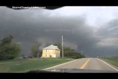
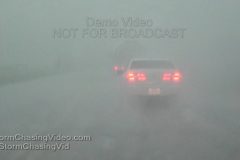
Scene 1-3: POV driving shots in blinding RFD-driven rain just south of the reported tornado near Elgin. Tornado was within a mile as winds of nearly 80mph blow. Third shot passing fire truck after RFD subsided. Chaser retreated south out of storm for reasons of safety.
LAWTON, OKLAHOMA SEGMENT (0:31-3:17)
The supercell to the south of the tornado-producer moved into Lawton with severe hail and rains the flooded streets in town.
Scene 4-5: POV driving shots in Lawton with water starting to fill roads.
Scene 6: Severe hail up to 1.25-inch falling in grass.
Scene 7-8: Cars taking cover at a gas station during hail.
Scene 9: Vehicle turns through street flooding.
Scene 10: POV driving shot of a Lawton road looking like a small river.
Scene 11-20: Various shots of cars driving through street flooding in town.
Scene 21-26: SPRINGER, OKLAHOMA shelf cloud and whale’s mouth shots as the line of storms hits I-35 south of OKC early evening.
Live Track: http://goo.gl/eoGVBW
See all streams LIVE and recorded: http://liveweather.tv
SCV stringer Eric Treece is LIVE now on developing severe weather threat in Central Kansas. One Tornado warning has been issued and a Tornado watch is already up. Live storm chasing video.
*** No Third Party Use w/o License ***
SID=EricT
Severe storms erupted across northwest Texas leaving hail and street flooding in their wake. This was the first storm of the day as a localized outbreak was expected to develop Sunday evening across Texas and Oklahoma. This cluster of storms formed southwest of Vernon and moved over town dropping nearly 2 inches of rain and 1-inch hail leading to street flooding in town. Vehicles took shelter from the storm under highway overpasses as well as various other structures in town until the storm passed.
Video package shot in Vernon, Texas which is 50 miles west/northwest of Wichita Falls, TX on US-287.
Scenes 1-4: POV driving shots along US-70 heading into Vernon as blinding rain and hail come down.
Scene 5-6: Shots of numerous vehicles under the overpass of US-70 and US-287 in Vernon, completely blocking one side of the road.
Scene 7: High winds blowing a Texas windmill around in a front yard.
Scene 8: Hail bouncing in the grass in front of cacti.
Scene 9: Shot of 1-inch hailstones bouncing feverishly in a front yard.
Scene 10-14: Various shots of heavy hail falling on streets and yards.
Scene 15: Panning shot of a truck with a trailer driving through flood waters on the business route in Vernon.
Scene 16-17: White pickup truck driving through foot-deep flood waters on a neighborhood street in Vernon.
Scene 18: Red car approaching camera in flood waters on a neighborhood street in Vernon.
Scene 19-23: Various shots of vehicles driving through flood waters in Vernon.