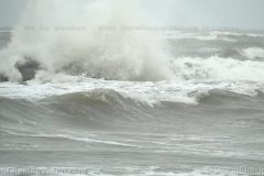
Large waves, creeping storm surge, and gusting winds in Grand Isle, LA as first feeder bands from CAT 2 Hurricane Zeta move onshore.
All footage shot in/near Grand Isle, LA during afternoon daylight on October 28, 2020 by Meteorologist Simon Brewer
Shot Description
1-6. various shots of large waves crashing against Grand Isle, LA from approaching CAT 2 Hurricane Zeta
7-12. various shots of storm surge creeping over neighborhoods in Grand Isle, LA in advance of CAT 2 Hurricane Zeta
13 & 14. flags blowing in high winds as CAT 2 Hurricane Zeta approaches Grand Isle, LA
15. “Hurricane Evacuation Route” sign with high winds in Grand Isle, LA
16-18. various shots of signs, palm trees, and flag blowing in gusting winds in Grand Isle, LA
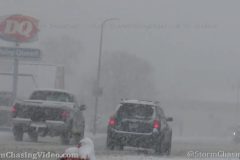
19 & 20. vehicles driving in first feeder bands coming onshore near Grand Isle, LA
21. Workers testing flood gates in advance of CAT 2 Hurricane Zeta near Grand Isle, LA
SID: Simon Brewer
A large winter weather system moving through the southern Plains is blanketing multiple states in ice. The massive ice storm hammering Oklahoma stretched into southern Kansas just in time for the morning commute leading to dozens of crashes and closures of major highways in Greater Wichita. Up to 0.20″ of ice was measured around Wichita as a mixture of sleet and freezing rain fell through the morning.
Shot Description
Clip 1: POV driving shot passing KDOT highway sign warning drivers of icy roads.
Clips 2-10: Shots of a four-car crash on a bridge in west Wichita involving three pickups and a car. This crash closed westbound Kellogg (US 400/US-54) for a couple hours during the morning commute. Includes POV shots approaching wreck, as well as different zooms of the heavily damaged vehicles involved.
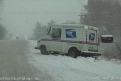
Clips 11-13: Police on scene of an SUV that spun around into the ditch off I-235, the woman drive runhurt and getting into her truck while waiting a tow.
Clips 14-16: Police on scene of a white car the spun off I-235 and into a tree.
Clips 17-19: SUV spun out into the median and a jeep strapping it up with a tow rope and pulling it back onto the highway.
Clips 20-21: Car in the median at the junction of I-235 and Kellogg.
Clips 22-23: Beige pickup with damaged front end after sliding into bridge barrier.
Clips 24-25: Red car spun well off into the ditch of the side of the highway.
Clips 26-27: KDOT sign warning drivers of closed highway due to crash.
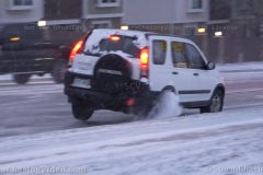
A major winter storm associated with a whiplash of temperatures ushers in heavy snow and ice, causing havoc on the roads in Colorado Springs, Colo., on Oct. 25, 2020.
Shot Description
00:00 – Tires squeal as a vehicle slides on ice and makes a hard impact with the curb on Dublin Blvd..
00:14 – A Minivan fails to make it up a short hill, spinning its tires in the process on Dublin Blvd..
00:29 – A passerby who stopped to check on the minivan driving a lifted Jeep, tries to get away from the curb but ends up spinning their tires as they make a u-turn and slide.
00:45 – Stuck car in the middle lane of an uphill road emerges from the low visibility prompting other traffic to switch lanes.
01:02 – Heavy snow and low visibility eastbound on Woodman Rd.
01:15 – Vehicles travelling on a snow covered Woodman Rd.
01:26 – Low visibility and heavy snow on Dublin Blvd.
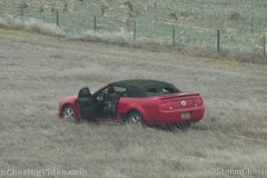
First major winter storm of the year moving into the Plains and will bring the first snow for many areas across the state along with some of coldest temperatures recorded in the month of October for cities across western Kansas.
Light freezing drizzle began early Sunday morning before changing over to light snow and accumulations began late in the afternoon across far northwest Kansas as heavier snow began to move in, signalling the start to what will accumulate half a foot or more across parts of the region.
Icy spots on I-70 created some early travel issues and snow blowing across the interstate also limited visibility at times. Snow started to accumulate in Goodland by late afternoon.
Shot Description
Clips 1-2: Shots of KDOT highway sign warning drivers of icy conditions on I-70 in Sherman County.
Clips 3-6: Red Mustang that slid off the highway way down the embankment trying to slowly drive across icy grass to find a level spot to get back on the highway. Various zooms of the scene.
Clips 7-9: POV driving shots of blowing snow across I-70 on the drive into Goodland.
Clips 10-11: Snow falling on the Goodland Water Tower.
Clips 12-13; Heavy snow falling at the junction of I-70 and K-27, the main exit into Goodland from I-70.
Clips 14-15: Heavy snow falling on K-27 in Goodland with traffic driving by.
Clip 16: POV driving shot down K-27 with snow blowing across the view.
Clip 17: White van turning out of frame in heavy falling snow in town.
Clips 18-19: Heavy snow falling against pine trees in town.
Clip 20: Bunch of birds on the snow covered road fly up as a passing car drives through heavy falling snow.
Clips 21-23: Various shots of birds on the snow as flakes fly.
SID: Tornadoes Kick Media
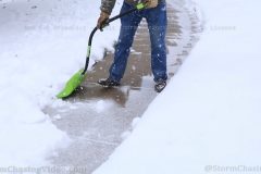
Video footage from the Minneapolis/St.Paul area of the first major impacting Winter Storm of Warning Criteria of the 2020/2021 Fall/Winter Season. Video highlights the significant impacts to the afternoon commute and catching even hardy Minnesotans off guard!
Shot Description
1. Heavy Snow Falling at 1 inch per hour rates in Minneapolis MN.
2. Minneapolis Snow Plow Rig moving heavy wet snow from the roadways.
3. St.Paul MN Man shoveling the back breaking heavy wet snow.
4-6. Twin Cities Snowplow Operations Footage (First Of Season 20/21).
7. Kids Playing and sledding on a hill with snowman in Minneapolis.
8. Heavy gridlock Traffic in St.Paul MN with heavy snowfall.
9. Truck smashed in a spin out crash with Police.
10. Car stuck in snow spinning tire and going backwards up a hill!
11. Fall Foliage scene with rare early Heavy Snowstorm in Minneapolis MN.
12. POV Scene of a Early Start to Winter over Minneapolis.
13. Woman Clearing Her Car of 9 inches of heavy wet snow.
An early winter storm hits northwestern WI. This video was shot in and around Rice Lake WI.
The snow was coming down really heavy at times. The snow caused some traffic problems across the area.
Shot Description
Clip1. A car lost control at an intersection, and hit a curb causing the car to bounce off of said curb, almost into oncoming traffic. Driver was able to regain control before that happened.
Clip 2. Barron County HWY Department. getting an early start on plowing HWY 48 just east of Rice Lake, WI.
Clips 3-5. City of Rice Lake Street Department. Plowing main street in Rice Lake.
Clip 6. Someone walking through the shot of the snow covered cars in the store’s parking lot, and shrubs.
Clip 7. Snow covered cars in the store’s parking lot.
Clip 8. Heavy snow falling in the city of Rice Lake, with traffic driving through the shot.
Clip 9. Snow, and slush covered main street is causing traffic to slow down.
Clip 10. Close up shot of the snow, and slush covered street, with tires kicking up the snow, and slush.
Clip 11. Snow covered trees, and powerlines, with heavy snow falling.
Clip 12. A snow covered corn field just north of Rice Lake.
Clip 13-14. Snow covered corncobs.
Clip 15. Stop lights getting covered in snow.
Various shots of the winter storm around the Scott County, MN area near New Prague, MN.
Shot Description
Twin Cities record area early record snowfall. 0 minutes truck in ditch with State Trooper. 12 seconds in spun out United States postal truck. 22 seconds in plow coming at you 27 seconds in following plow 37 seconds in following City plow 52nd Saint following farm machinery down Road one minute cornfield not harvested yet was snow on it 1 minute 8 seconds residential plow 1 minute 15 seconds snow falling on City Church st. Wenceslas Catholic Church.
Footage shot in the whiteout conditions along Interstate 94 around the Sauk Centre, MN area where Interstate 94 was closed due to a multi vehicle pileup crash near the Sauk River Bridge. Additional footage shot around Saint Cloud, MN at the end of the video.
Shot Description
Clip 1 The start of the pile up with a two vehicle crash just east of Sauk Centre.
Clip 2 – 3 Emergency vehicles on the scene of the pile up that happened just behind me. By the time I was able to get turned around the Interstate was shut down.
Clip 4 Fire crews on the scene of the pile up.
Clip 5 – 9 Vehicles in the ditch.
Clip 10 POV Snow Plow
Clip 11 – 12 Traffic in very low visibility white out conditions.
Clip 13 – 14 Snow plows.
Clip 15 Jeep swerving to avoid a truck pulled over to the side of the road.
Clip 16 – end Snow plows in Saint Cloud, MN on Highway 23
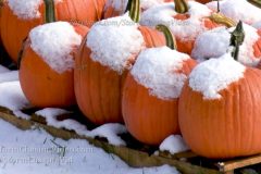
After the morning’s snowfall. Another band of heavy snow moved through Barron County WI. Started with a period of sleet before switching over to heavy snow. This band of snow brought 1.25 inches of snow to the Rice Lake area. This video shows the beauty that was left in it’s wake.
Shot Description
Clip 1. A wide shot of snow on the pumpkins.
Clip 2. Medium shot of snow on the pumpkins.
Clip 3. Close up shot of the pumpkins covered with snow.
Clip 4. A snow covered roof.
Clip 5. Snow covered trees.
Clip 6. Wide shot looking across Red Cedar River with snow covered trees and houses.
Clip 7. Close shot of the snow covered houses and trees across the Red Cedar River.
Clip 8. Snow on the remaining fall colors.
Clip 9. Snow on pines trees, and the reaming fall colors.
Clip 10. Snow melting off a vehicle.
Clip 11. Snow on a dock, and pontoon boat.
Clip 12. Another snow covered roof.
Clip 13. Snow covered pine branches.
Clip 14. A ruler showing close to 1.25 inches of snow. Some of it melted down by time I was able to get back outside.
Most of Barron County had seen their first snowfall of the season this morning. Some areas the ground was turning white with the heaviest snow bands.
Shot Description
Clip 1. Snow covered field.
Clip 2. Heavy snow falling with the ground turning white.
Clip 3. Another snow covered field with snow falling.
Clip 4. A sign getting covered by snow. With heavy snow falling.
Clip 5. A power pole with snow sticking to it, as heavy snow is falling.
Clip 6. Snow sticking to the ground.
Clip 7. Heavy snow falling.
Clip 8. Another field turning white.
Clip 9. Some falling with some remaining fall color.
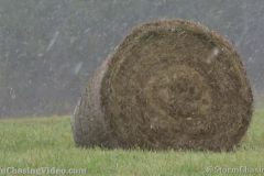
Clip 10. A round haybale with snow starting to fall at a good clip.
Clip 11. A close shot of the round haybale and snow falling.
Clip 12. Another shot of the remaining fall colors with snow falling.
Clip 13. Looking down a road with pine trees with light snow falling.
Clip 14. A closer shot of the remain fall colors with snow.
Clip 15. A field slowly turning whit.
Clip 16. Big snow flakes falling and sticking to the hood of a vehicle.
SID: Dirk Miller
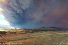
The Cameron Peak Fire has exploded today with 60-80 mph winds, multiple structures have been lost, and the fire is moving uncontrolled South and East of the Southern edge of the fire. This is video from a DJI Mavic 2 Pro outside of the temporary flight restriction area from the city limits of Loveland, CO approximately 1 PM October 14th.
Video pans around to show the huge smoke cloud covering most of Northern Colorado today.
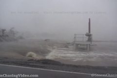
Hurricane Delta landfall, surge, and eye in Creole, LA on Oct 9, 2020.
Shot Description
1. Flooded road leading to Rutherford Beach.
2. Trees along side of road whipping.
3. Gopro shot of roadway in eyewall. Powelines whipping.
4. Powerlines whipping.
5. Eyewall white-out conditions in Creole, LA.
6. GoPro shot of surged roadway.
7. Raging surge water.
8. Destroyed house being destroyed “again”.
9. Entering calm eye. Surge spilling over roadway.
10. Dead calm, water like mirror in eye.
11. Brief view of blue sky.
12. Second half of storm begins.
13. Gopro shot of second half starting.
14. Myself trying to stand in strong winds.
SID: CHRISTOPHER COLLURA
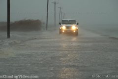
Powerful eyewall of CAT 2 Hurricane Delta slams Creole, LA and storm surge pushes over highways
All footage shot during afternoon daylight on October 9, 2020 in Creole, LA by Meteorologist Simon Brewer
Shot Description
1-4. Highway overtaken by storm surge in Creole, LA with Jeep driving through water
5. fish on highway as storm surge rises in Creole, LA
6-16. various shots of storm surge and high winds as eyewall of CAT 2 Hurricane Delta move over Creole, LA
SID: Simon Brewer