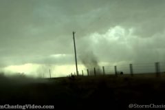
B-Roll footage of the dusty Alma Nebraska tornado with hail core intercept.
Shot Description
Hail shaft ahead over Oxford Nebraska from 4 miles out
Sitting in Hail core in Orleans Nebraska
Driving in Hail core leaving Orleans Nebraska
Wall cloud forms South of Alma Nebraska
Tornado touchdown south of Alma Nebraska
New Wall Cloud on Kansas Nebraska Border north of Philipsburg Kansas
SID: Tim Baker
To License This Footage For Broadcast, Contact Video @ StormChasingVideo.com
#NEWX
#Tornado
#HAIL
#SevereStorm
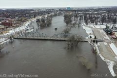
The Red River is on the rise between Grand Forks, ND and East Grand Forks, MN. Today the cities shut down The Sorlie Bridge by default after installing the flood gates into the permanent levee system on both sides of the river. The Red River at GF is at 44 feet today and expected to crest at 48 feet in the next 48 hours. The 1997 historic crest was 54.35 feet and Grand Forks’ flood walls are now built to 63 feet. Video includes aerial views of the river today and a fun cruise across the empty Sorlie Bridge.
Shot Description
Various shots of the Sorlie Bridge from the drone with flooding.
SID: Jason Bednar
To License This Footage For Broadcast, Contact Video @ StormChasingVideo.com
#NDWX
#Flooding
#RedRiver
#NDWX
The Red River Valley on the border of Minnesota and North Dakota has several flood warning in effect from the recent storms along with snowmelt. The Red Lake River at Crookston, MN is at major flood level today (4/24/22) at 26.25 feet with an expected crest Monday (4/25/22) afternoon of 28.5 feet which could overtake the record of 28.4 feet set during the disastrous RRV flood season of spring 1997. The city is well protected up to 31 feet, but several low lying areas are in danger and hundreds of volunteers were out sandbagging today to protect those areas.
Shot Description
1) Welcome to Crookston
2) Several clips of volunteers sandbagging via the human chain method. They are trying to save the Crookston Fire Department which sits in a low area on South Main Street. An earthen dyke is also being used in front of the fire department seen later in the video with a bulldozer on it.
3) Drone clips over the city of Crookston showing the Red Lake River in close proximity to its banks.
4) Red Lake River on the east edge of downtown, very high and very fast.
5) Earthen dyke being built in front of the Fire Station.
6) Sandbags and backup earthen dyke on the north side of town. Homes on the wrong side of the earthen dyke are at risk should the river overpower the current protection in place.
7) Pumps are running all over the city trying to return breached water back into the river.
SID: Jason Bednar
SID: Jason Bednar
To License This Footage For Broadcast, Contact Video @ StormChasingVideo.com
#MNWX
#Flooding
#RedRiver
#NDWX
Live storm chase in Western Minnesota where Tornado Watch 147 is in effect until 7:00 PM tonight.
Live stream location is starting up west of Morris, MN and may travel west into the Dakotas or stay in Minnesota as the storms develop today.
To License This Footage For Broadcast, Contact Video @ StormChasingVideo.com
#MNWX
#Tornado
#IRL
#StormChasing
Michael Gordon is out live streaming the severe tornado threat in Arkansas today. NWS SPC has upgraded the enhanced risk with a hatched area for violent tornadoes.
This stream will be running through the day as the severe weather threat continues.
SID: Michael Gordon
To License This Footage For Broadcast, Contact Video @ StormChasingVideo.com
#ARWX
#Tornado
#StormChasing
#SevereWeather
Large Tornado Ahead! Near Bennington, Kansas. From the archives of Scott McPartland. 5/28/13. #Shorts